More like 'COVID-19 warming centre #2'
Narrow Results By
Subject
- Advertising Medium - Signs and Signboards 1
- Buildings - Commercial 1
- Buildings - Commercial - General Stores 3
- Buildings - Commercial - Restaurants 1
- Buildings - Heritage 1
- Buildings - Industrial - Factories 4
- Buildings - Recreational - Community Halls 1
- Buildings - Residential - Houses 5
- Buildings - Schools 6
- Geographic Features - Gardens 1
- Geographic Features - Roads 2
- Natural Phenomena - Snow 1

Nordic Centre
https://search.heritageburnaby.ca/link/archivedescription79734
- Repository
- City of Burnaby Archives
- Date
- November 1, 1976
- Collection/Fonds
- Burnaby Public Library Contemporary Visual Archive Project
- Description Level
- Item
- Physical Description
- 1 photograph : b&w ; 11 x 16 cm mounted on cardboard
- Scope and Content
- Photograph shows the Nordic Centre, located on 6th Street on the corner of 12th Avenue. A billboard advertising its services is attached to the side of the building. A few months after this photo was taken, the Nordic Centre was torn down.
- Repository
- City of Burnaby Archives
- Date
- November 1, 1976
- Collection/Fonds
- Burnaby Public Library Contemporary Visual Archive Project
- Physical Description
- 1 photograph : b&w ; 11 x 16 cm mounted on cardboard
- Description Level
- Item
- Record No.
- 556-407
- Access Restriction
- No restrictions
- Reproduction Restriction
- Reproduce for fair dealing purposes only
- Accession Number
- 2013-13
- Scope and Content
- Photograph shows the Nordic Centre, located on 6th Street on the corner of 12th Avenue. A billboard advertising its services is attached to the side of the building. A few months after this photo was taken, the Nordic Centre was torn down.
- Names
- Nordic Centre
- Media Type
- Photograph
- Notes
- Scope note taken directly from BPL photograph description.
- 1 b&w copy negative : 10 x 12.5 cm accompanying
- Photographers identified by surnames only: Carr and Vardeman
- Geographic Access
- 6th Street
- 12th Avenue
- Historic Neighbourhood
- East Burnaby (Historic Neighbourhood)
- Planning Study Area
- Second Street Area
Images

![Moxham residence, [1929] (date of original) copied [2000] thumbnail](/media/hpo/_Data/_Archives_Images/_Unrestricted/371/388-001.jpg?width=280)
Moxham residence
https://search.heritageburnaby.ca/link/archivedescription38285
- Repository
- City of Burnaby Archives
- Date
- [1929] (date of original) copied [2000]
- Collection/Fonds
- Burnaby Historical Society fonds
- Description Level
- Item
- Physical Description
- 1 photograph : b&w ; 12.7 x 17.7 cm print
- Scope and Content
- Photograph of the Moxham residence, located at 1944 6th Street (old street numbering system). A note written on the back of the photograph reads: "Moxham residence, 1944 Sixth St., Burnaby. Built 1914 by Mr. Moxham. Photo taken ca. 1929."
- Repository
- City of Burnaby Archives
- Date
- [1929] (date of original) copied [2000]
- Collection/Fonds
- Burnaby Historical Society fonds
- Subseries
- Photographs subseries
- Physical Description
- 1 photograph : b&w ; 12.7 x 17.7 cm print
- Description Level
- Item
- Record No.
- 388-001
- Access Restriction
- No restrictions
- Reproduction Restriction
- No known restrictions
- Accession Number
- BHS2007-04
- Scope and Content
- Photograph of the Moxham residence, located at 1944 6th Street (old street numbering system). A note written on the back of the photograph reads: "Moxham residence, 1944 Sixth St., Burnaby. Built 1914 by Mr. Moxham. Photo taken ca. 1929."
- Media Type
- Photograph
- Notes
- Title based on caption
- Geographic Access
- 6th Street
- Historic Neighbourhood
- East Burnaby (Historic Neighbourhood)
- Planning Study Area
- Second Street Area
Images
![Moxham residence, [1929] (date of original) copied [2000] thumbnail](/media/hpo/_Data/_Archives_Images/_Unrestricted/371/388-001.jpg)
7818 6th Street
https://search.heritageburnaby.ca/link/archivedescription93731
- Repository
- City of Burnaby Archives
- Date
- 1989
- Collection/Fonds
- Grover, Elliott & Co. Ltd. fonds
- Description Level
- File
- Physical Description
- 26 photographs : col. negatives ; 35 mm
- Scope and Content
- Photographs of the exterior of a Benjamin Moore Paints store and surrounding area. The store is located on a corner opposite Microtel and outside the store, a sign for the Skytrain Operations and Maintenance Centre is visible.
- Repository
- City of Burnaby Archives
- Date
- 1989
- Collection/Fonds
- Grover, Elliott & Co. Ltd. fonds
- Physical Description
- 26 photographs : col. negatives ; 35 mm
- Description Level
- File
- Record No.
- 622-019
- Access Restriction
- No restrictions
- Reproduction Restriction
- No restrictions
- Accession Number
- 2017-39
- Scope and Content
- Photographs of the exterior of a Benjamin Moore Paints store and surrounding area. The store is located on a corner opposite Microtel and outside the store, a sign for the Skytrain Operations and Maintenance Centre is visible.
- Media Type
- Photograph
- Notes
- Transcribed title
- Title transcribed from original print envelope
- File no. 89v-004-O
- Property address could not be confirmed at time of description.
- Geographic Access
- 6th Street
- 12th Avenue
- Street Address
- 7818 6th Street
- Historic Neighbourhood
- East Burnaby (Historic Neighbourhood)
- Planning Study Area
- Second Street Area

Coldicutt House
https://search.heritageburnaby.ca/link/archivedescription34549
- Repository
- City of Burnaby Archives
- Date
- 1914
- Collection/Fonds
- Burnaby Historical Society fonds
- Description Level
- Item
- Physical Description
- 1 photograph : b&w ; 16.0 x 21.1 cm mounted on 25.1 x 30.1 cm cardboard
- Scope and Content
- Photograph of the exterior of the Coldicutt House at 7510 6th Street.
- Repository
- City of Burnaby Archives
- Date
- 1914
- Collection/Fonds
- Burnaby Historical Society fonds
- Subseries
- Photographs subseries
- Physical Description
- 1 photograph : b&w ; 16.0 x 21.1 cm mounted on 25.1 x 30.1 cm cardboard
- Description Level
- Item
- Record No.
- 044-009
- Access Restriction
- No restrictions
- Reproduction Restriction
- No known restrictions
- Accession Number
- BHS2007-04
- Scope and Content
- Photograph of the exterior of the Coldicutt House at 7510 6th Street.
- Media Type
- Photograph
- Notes
- Title based on contents of photograph
- Geographic Access
- 6th Street
- Street Address
- 7510 6th Street
- Historic Neighbourhood
- East Burnaby (Historic Neighbourhood)
- Planning Study Area
- Second Street Area
Images


Coldicutt house
https://search.heritageburnaby.ca/link/archivedescription36575
- Repository
- City of Burnaby Archives
- Date
- 1944
- Collection/Fonds
- Burnaby Historical Society fonds
- Description Level
- Item
- Physical Description
- 1 photograph : sepia ; 7 x 5 cm
- Scope and Content
- Photograph of the front of the Coldicutt House located at 6th Street and 16th Avenue.
- Repository
- City of Burnaby Archives
- Date
- 1944
- Collection/Fonds
- Burnaby Historical Society fonds
- Subseries
- Pixie McGeachie subseries
- Physical Description
- 1 photograph : sepia ; 7 x 5 cm
- Description Level
- Item
- Record No.
- 299-001
- Access Restriction
- No restrictions
- Reproduction Restriction
- No known restrictions
- Accession Number
- BHS1992-39
- Scope and Content
- Photograph of the front of the Coldicutt House located at 6th Street and 16th Avenue.
- Subjects
- Buildings - Residential - Houses
- Media Type
- Photograph
- Notes
- Title based on contents of photograph
- Geographic Access
- 6th Street
- Street Address
- 7510 6th Street
- Historic Neighbourhood
- East Burnaby (Historic Neighbourhood)
- Planning Study Area
- Second Street Area
Images

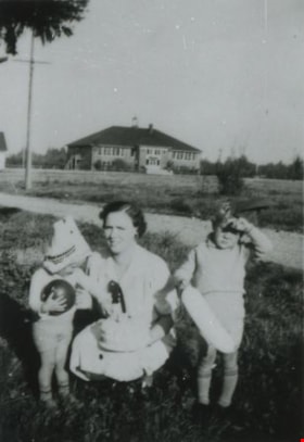
Dunn family
https://search.heritageburnaby.ca/link/archivedescription37683
- Repository
- City of Burnaby Archives
- Date
- October 1937 (date of original), copied 1991
- Collection/Fonds
- Burnaby Historical Society fonds
- Description Level
- Item
- Physical Description
- 1 photograph : b&w ; 4.1 x 2.8 cm print on contact sheet 20.2 x 25.3 cm
- Scope and Content
- Photograph of Ilma Dunn (centre) and her sons, Robert Dunn (left) and Fred Dunn (right), with 2nd Street School in the background. They each have toys in their hands. Robert is wearing a mask pushed to the top of his head.
- Repository
- City of Burnaby Archives
- Date
- October 1937 (date of original), copied 1991
- Collection/Fonds
- Burnaby Historical Society fonds
- Subseries
- Burnaby Image Bank subseries
- Physical Description
- 1 photograph : b&w ; 4.1 x 2.8 cm print on contact sheet 20.2 x 25.3 cm
- Description Level
- Item
- Record No.
- 370-271
- Access Restriction
- No restrictions
- Reproduction Restriction
- No known restrictions
- Accession Number
- BHS1999-03
- Scope and Content
- Photograph of Ilma Dunn (centre) and her sons, Robert Dunn (left) and Fred Dunn (right), with 2nd Street School in the background. They each have toys in their hands. Robert is wearing a mask pushed to the top of his head.
- Subjects
- Buildings - Schools
- Toys
- Media Type
- Photograph
- Notes
- Title based on contents of photograph
- 1 b&w copy negative accompanying
- Negative has a pink cast
- Geographic Access
- 2nd Street
- Street Address
- 7502 2nd Street
- Historic Neighbourhood
- East Burnaby (Historic Neighbourhood)
- Planning Study Area
- Second Street Area
Images

![George Leaf General Store, [1905] thumbnail](/media/hpo/_Data/_Archives_Images/_Unrestricted/204/204-216.jpg?width=280)
George Leaf General Store
https://search.heritageburnaby.ca/link/archivedescription35359
- Repository
- City of Burnaby Archives
- Date
- [1905]
- Collection/Fonds
- Burnaby Historical Society fonds
- Description Level
- Item
- Physical Description
- 1 photograph : b&w ; 12.7 x 17.8 cm print
- Scope and Content
- Photograph of the George Leaf general store, at 7745 6th Street. Identified are: (left to right) Andy Johnston, Bill Bailey, Harry Archibald, Ed Harris, Bob Burgess (George Leaf's half-brother), and Tom Breen. All were staff members of the store, which was one of the earliest businesses in Burnaby…
- Repository
- City of Burnaby Archives
- Date
- [1905]
- Collection/Fonds
- Burnaby Historical Society fonds
- Subseries
- Pioneer Tales subseries
- Physical Description
- 1 photograph : b&w ; 12.7 x 17.8 cm print
- Description Level
- Item
- Record No.
- 204-216
- Access Restriction
- No restrictions
- Reproduction Restriction
- No known restrictions
- Accession Number
- BHS1988-03
- Scope and Content
- Photograph of the George Leaf general store, at 7745 6th Street. Identified are: (left to right) Andy Johnston, Bill Bailey, Harry Archibald, Ed Harris, Bob Burgess (George Leaf's half-brother), and Tom Breen. All were staff members of the store, which was one of the earliest businesses in Burnaby. In the reflection of the store window at the right is the streetcar station on the opposite side of the street. This store burned down in 1913, and a second one was built on Keefer Road (now McKay Avenue).
- Names
- Archibald, Harry
- Bailey, Bill
- Breen, Tom
- Burgess, Bob
- George Leaf General Store
- Harris, Ed
- Johnston, Andy
- Media Type
- Photograph
- Notes
- Title based on contents of photograph
- Geographic Access
- 6th Street
- Street Address
- 7745 6th Street
- Historic Neighbourhood
- East Burnaby (Historic Neighbourhood)
- Planning Study Area
- Edmonds Area
Images
![George Leaf General Store, [1905] thumbnail](/media/hpo/_Data/_Archives_Images/_Unrestricted/204/204-216.jpg)
![George Leaf General Store, [1905] (date of original), copied 1986 thumbnail](/media/hpo/_Data/_Archives_Images/_Unrestricted/204/204-217.jpg?width=280)
George Leaf General Store
https://search.heritageburnaby.ca/link/archivedescription35360
- Repository
- City of Burnaby Archives
- Date
- [1905] (date of original), copied 1986
- Collection/Fonds
- Burnaby Historical Society fonds
- Description Level
- Item
- Physical Description
- 1 photograph : b&w ; 12.7 x 17.8 cm print
- Scope and Content
- Photograph of the inside of the George Leaf General Store and post office at 12th Avenue and 6th Street, 7745 6th Street. This was one of the earliest businesses in Burnaby. This store burned down in 1913, and a second one was built on Keefer Road (now McKay Avenue).
- Repository
- City of Burnaby Archives
- Date
- [1905] (date of original), copied 1986
- Collection/Fonds
- Burnaby Historical Society fonds
- Subseries
- Pioneer Tales subseries
- Physical Description
- 1 photograph : b&w ; 12.7 x 17.8 cm print
- Description Level
- Item
- Record No.
- 204-217
- Access Restriction
- No restrictions
- Reproduction Restriction
- No known restrictions
- Accession Number
- BHS1988-03
- Scope and Content
- Photograph of the inside of the George Leaf General Store and post office at 12th Avenue and 6th Street, 7745 6th Street. This was one of the earliest businesses in Burnaby. This store burned down in 1913, and a second one was built on Keefer Road (now McKay Avenue).
- Media Type
- Photograph
- Notes
- Title based on contents of photograph
- Geographic Access
- 6th Street
- Street Address
- 7745 6th Street
- Historic Neighbourhood
- East Burnaby (Historic Neighbourhood)
- Planning Study Area
- Edmonds Area
Images
![George Leaf General Store, [1905] (date of original), copied 1986 thumbnail](/media/hpo/_Data/_Archives_Images/_Unrestricted/204/204-217.jpg)
![George Leaf General Store, [1905] (date of original), copied 1986 thumbnail](/media/hpo/_Data/_Archives_Images/_Unrestricted/204/204-218.jpg?width=280)
George Leaf General Store
https://search.heritageburnaby.ca/link/archivedescription35361
- Repository
- City of Burnaby Archives
- Date
- [1905] (date of original), copied 1986
- Collection/Fonds
- Burnaby Historical Society fonds
- Description Level
- Item
- Physical Description
- 1 photograph : b&w ; 12.7 x 17.8 cm print
- Scope and Content
- Photograph of the inside of the George Leaf General Store and post office at 12th Avenue and 6th Street, 7745 6th Street. This was one of the earliest businesses in Burnaby. This store burned down in 1913, and a second one was built on Keefer Road .
- Repository
- City of Burnaby Archives
- Date
- [1905] (date of original), copied 1986
- Collection/Fonds
- Burnaby Historical Society fonds
- Subseries
- Pioneer Tales subseries
- Physical Description
- 1 photograph : b&w ; 12.7 x 17.8 cm print
- Description Level
- Item
- Record No.
- 204-218
- Access Restriction
- No restrictions
- Reproduction Restriction
- No known restrictions
- Accession Number
- BHS1988-03
- Scope and Content
- Photograph of the inside of the George Leaf General Store and post office at 12th Avenue and 6th Street, 7745 6th Street. This was one of the earliest businesses in Burnaby. This store burned down in 1913, and a second one was built on Keefer Road .
- Media Type
- Photograph
- Notes
- Title based on contents of photograph
- Geographic Access
- 6th Street
- Street Address
- 7745 6th Street
- Historic Neighbourhood
- East Burnaby (Historic Neighbourhood)
- Planning Study Area
- Edmonds Area
Images
![George Leaf General Store, [1905] (date of original), copied 1986 thumbnail](/media/hpo/_Data/_Archives_Images/_Unrestricted/204/204-218.jpg)

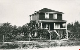
Moxham family house
https://search.heritageburnaby.ca/link/archivedescription34818
- Repository
- City of Burnaby Archives
- Date
- 1929
- Collection/Fonds
- Burnaby Historical Society fonds
- Description Level
- Item
- Physical Description
- 1 photograph : b&w ; 7.0 x 11.5 cm
- Scope and Content
- Photograph of the exterior of the Moxham family house at 1944 6th Street (later renumbered 7337 6th Street). This house was built in 1914 by Mr. Godfrey Moxham.
- Repository
- City of Burnaby Archives
- Date
- 1929
- Collection/Fonds
- Burnaby Historical Society fonds
- Subseries
- Kathleen Moore family subseries
- Physical Description
- 1 photograph : b&w ; 7.0 x 11.5 cm
- Description Level
- Item
- Record No.
- 139-001
- Access Restriction
- No restrictions
- Reproduction Restriction
- No known restrictions
- Accession Number
- BHS1985-09
- Scope and Content
- Photograph of the exterior of the Moxham family house at 1944 6th Street (later renumbered 7337 6th Street). This house was built in 1914 by Mr. Godfrey Moxham.
- Subjects
- Buildings - Residential - Houses
- Media Type
- Photograph
- Notes
- Title based on contents of photograph
- Geographic Access
- 6th Street
- Street Address
- 7337 6th Street
- Historic Neighbourhood
- East Burnaby (Historic Neighbourhood)
- Planning Study Area
- Edmonds Area
Images

![Second Street Community School garden, [2000] thumbnail](/media/hpo/_Data/_Archives_Images/_Unrestricted/535/535-2425.jpg?width=280)
Second Street Community School garden
https://search.heritageburnaby.ca/link/archivedescription96867
- Repository
- City of Burnaby Archives
- Date
- [2000]
- Collection/Fonds
- Burnaby NewsLeader photograph collection
- Description Level
- Item
- Physical Description
- 1 photograph (tiff) : col.
- Scope and Content
- Photograph of students Amanda Wilkes, Chantal Vicente, and Michael Gerow in the community garden at Second Street Community School.
- Repository
- City of Burnaby Archives
- Date
- [2000]
- Collection/Fonds
- Burnaby NewsLeader photograph collection
- Physical Description
- 1 photograph (tiff) : col.
- Description Level
- Item
- Record No.
- 535-2425
- Access Restriction
- No restrictions
- Reproduction Restriction
- No restrictions
- Accession Number
- 2018-12
- Scope and Content
- Photograph of students Amanda Wilkes, Chantal Vicente, and Michael Gerow in the community garden at Second Street Community School.
- Names
- Second Street School
- Media Type
- Photograph
- Photographer
- Bartel, Mario
- Notes
- Title based on caption
- Collected by editorial for use in a May 2000 issue of the Burnaby NewsLeader
- Caption from metadata: "Amanada Wilkes plants in the garden, while Chantal Vicente and Michael Gerow enjoy a book on a park bench, in the community garden at Second Street Community School. The school recently received a provincial grant to add the benches and other features to the garden."
- Geographic Access
- 2nd Street
- Street Address
- 7502 2nd Street
- Historic Neighbourhood
- East Burnaby (Historic Neighbourhood)
- Planning Study Area
- Second Street Area
Images
![Second Street Community School garden, [2000] thumbnail](/media/hpo/_Data/_Archives_Images/_Unrestricted/535/535-2425.jpg)
![Second Street School, [January 1978] thumbnail](/media/hpo/_Data/_Archives_Images/_Unrestricted/550/556-621.jpg?width=280)
Second Street School
https://search.heritageburnaby.ca/link/archivedescription93664
- Repository
- City of Burnaby Archives
- Date
- [January 1978]
- Collection/Fonds
- Burnaby Public Library Contemporary Visual Archive Project
- Description Level
- Item
- Physical Description
- 1 photograph : b&w ; 12.5 x 17.5 cm
- Scope and Content
- Photograph of the schoolyard and exterior of Second Street School. The photograph is taken from across the field, facing east. The photograph shows children playing in the field and the old school building, built in 1928, and the newer additions to the school. The mountains are visible in the backg…
- Repository
- City of Burnaby Archives
- Date
- [January 1978]
- Collection/Fonds
- Burnaby Public Library Contemporary Visual Archive Project
- Physical Description
- 1 photograph : b&w ; 12.5 x 17.5 cm
- Description Level
- Item
- Record No.
- 556-621
- Access Restriction
- No restrictions
- Reproduction Restriction
- Reproduce for fair dealing purposes only
- Accession Number
- 2017-57
- Scope and Content
- Photograph of the schoolyard and exterior of Second Street School. The photograph is taken from across the field, facing east. The photograph shows children playing in the field and the old school building, built in 1928, and the newer additions to the school. The mountains are visible in the background.
- Subjects
- Buildings - Schools
- Names
- Second Street School
- Media Type
- Photograph
- Photographer
- Surridge, Jack
- Notes
- Title taken from project information form
- Accompanied by a project information form and 1 photograph (b&w negative ; 9.5 x 12.5 cm)
- BPL no. 70
- Geographic Access
- 2nd Street
- Street Address
- 7502 2nd Street
- Historic Neighbourhood
- East Burnaby (Historic Neighbourhood)
- Planning Study Area
- Second Street Area
Images
![Second Street School, [January 1978] thumbnail](/media/hpo/_Data/_Archives_Images/_Unrestricted/550/556-621.jpg)
![Second Street School, [between 1913 and 1919] thumbnail](/media/hpo/_Data/_Archives_Images/_Unrestricted/316/325-032.jpg?width=280)
Second Street School
https://search.heritageburnaby.ca/link/archivedescription37160
- Repository
- City of Burnaby Archives
- Date
- [between 1913 and 1919]
- Collection/Fonds
- Burnaby Historical Society fonds
- Description Level
- Item
- Physical Description
- 1 photograph : b&w ; 7.5 x 10 cm print
- Scope and Content
- Photograph of Second Street School taken from a distance.
- Repository
- City of Burnaby Archives
- Date
- [between 1913 and 1919]
- Collection/Fonds
- Burnaby Historical Society fonds
- Subseries
- Disney family subseries
- Physical Description
- 1 photograph : b&w ; 7.5 x 10 cm print
- Description Level
- Item
- Record No.
- 325-032
- Access Restriction
- No restrictions
- Reproduction Restriction
- No known restrictions
- Accession Number
- BHS1996-04
- Scope and Content
- Photograph of Second Street School taken from a distance.
- Subjects
- Buildings - Schools
- Names
- Second Street School
- Media Type
- Photograph
- Photographer
- Disney, John Harold "Jack"
- Notes
- Title based on contents of photograph
- Geographic Access
- 2nd Street
- Street Address
- 7502 2nd Street
- Historic Neighbourhood
- East Burnaby (Historic Neighbourhood)
- Planning Study Area
- Second Street Area
Images
![Second Street School, [between 1913 and 1919] thumbnail](/media/hpo/_Data/_Archives_Images/_Unrestricted/316/325-032.jpg)
![Second Street School, [between 1913 and 1919] thumbnail](/media/hpo/_Data/_Archives_Images/_Unrestricted/316/325-033.jpg?width=280)
Second Street School
https://search.heritageburnaby.ca/link/archivedescription37161
- Repository
- City of Burnaby Archives
- Date
- [between 1913 and 1919]
- Collection/Fonds
- Burnaby Historical Society fonds
- Description Level
- Item
- Physical Description
- 1 photograph : b&w ; 8 x 12.5 cm print
- Scope and Content
- Photograph of Second Street School.
- Repository
- City of Burnaby Archives
- Date
- [between 1913 and 1919]
- Collection/Fonds
- Burnaby Historical Society fonds
- Subseries
- Disney family subseries
- Physical Description
- 1 photograph : b&w ; 8 x 12.5 cm print
- Description Level
- Item
- Record No.
- 325-033
- Access Restriction
- No restrictions
- Reproduction Restriction
- No known restrictions
- Accession Number
- BHS1996-04
- Scope and Content
- Photograph of Second Street School.
- Subjects
- Buildings - Schools
- Names
- Second Street School
- Media Type
- Photograph
- Photographer
- Disney, John Harold "Jack"
- Notes
- Title based on contents of photograph
- Geographic Access
- 2nd Street
- Street Address
- 7502 2nd Street
- Historic Neighbourhood
- East Burnaby (Historic Neighbourhood)
- Planning Study Area
- Second Street Area
Images
![Second Street School, [between 1913 and 1919] thumbnail](/media/hpo/_Data/_Archives_Images/_Unrestricted/316/325-033.jpg)

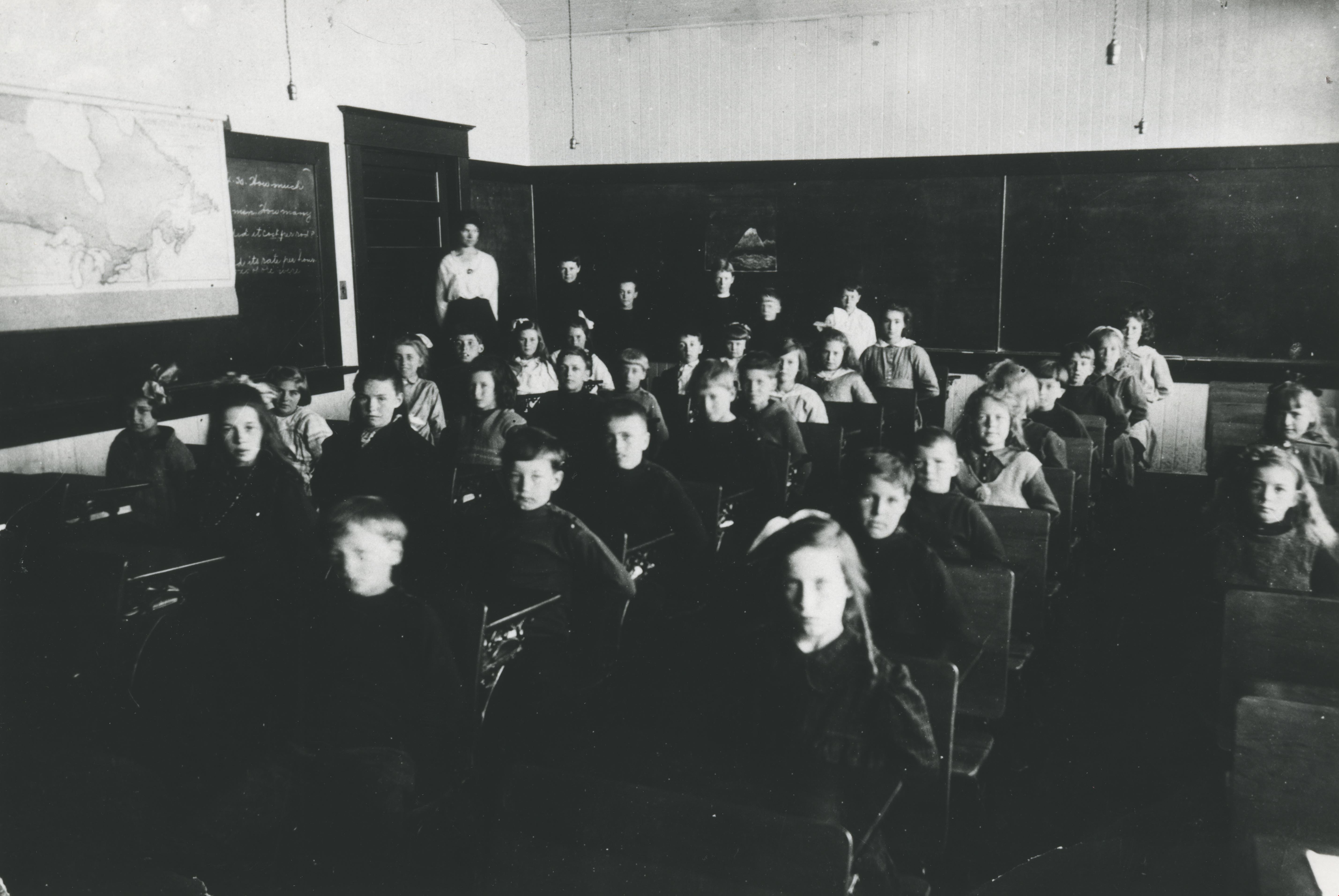
Second Street School Class
https://search.heritageburnaby.ca/link/archivedescription34805
- Repository
- City of Burnaby Archives
- Date
- 1920 (date of original), copied 1985
- Collection/Fonds
- Burnaby Historical Society fonds
- Description Level
- Item
- Physical Description
- 1 photograph : b&w ; 20.2 x 25.3 cm print
- Scope and Content
- Photograph of a Second Street School classroom. The students are seated at desks, and the teacher is standing behind them beside a chalkboard and a map.
- Repository
- City of Burnaby Archives
- Date
- 1920 (date of original), copied 1985
- Collection/Fonds
- Burnaby Historical Society fonds
- Subseries
- Ethel Derrick subseries
- Physical Description
- 1 photograph : b&w ; 20.2 x 25.3 cm print
- Description Level
- Item
- Record No.
- 136-001
- Access Restriction
- No restrictions
- Reproduction Restriction
- No known restrictions
- Accession Number
- BHS1985-05
- Scope and Content
- Photograph of a Second Street School classroom. The students are seated at desks, and the teacher is standing behind them beside a chalkboard and a map.
- Names
- Second Street School
- Media Type
- Photograph
- Notes
- Title based on contents of photograph
- Geographic Access
- 2nd Street
- Street Address
- 7502 2nd Street
- Historic Neighbourhood
- East Burnaby (Historic Neighbourhood)
- Planning Study Area
- Second Street Area
Images
![Starlite Room fire, [2003] thumbnail](/media/hpo/_Data/_Archives_Images/_Unrestricted/535/535-2044.jpg?width=280)
Starlite Room fire
https://search.heritageburnaby.ca/link/archivedescription96363
- Repository
- City of Burnaby Archives
- Date
- [2003]
- Collection/Fonds
- Burnaby NewsLeader photograph collection
- Description Level
- Item
- Physical Description
- 1 photograph (tiff) : col.
- Scope and Content
- Photograph of two Burnaby fire fighters outside of the Starlite Room banquet hall after fighting a fire. One fire fighter is climbing down a ladder as the other holds it. The Starlite Room's sign is visible in the background.
- Repository
- City of Burnaby Archives
- Date
- [2003]
- Collection/Fonds
- Burnaby NewsLeader photograph collection
- Physical Description
- 1 photograph (tiff) : col.
- Description Level
- Item
- Record No.
- 535-2044
- Access Restriction
- No restrictions
- Reproduction Restriction
- No restrictions
- Accession Number
- 2018-12
- Scope and Content
- Photograph of two Burnaby fire fighters outside of the Starlite Room banquet hall after fighting a fire. One fire fighter is climbing down a ladder as the other holds it. The Starlite Room's sign is visible in the background.
- Names
- Burnaby Fire Department
- Media Type
- Photograph
- Photographer
- Bartel, Mario
- Notes
- Title based on caption
- Collected by editorial for use in a March 2003 issue of the Burnaby NewsLeader
- Caption from metadata: "Burnaby firefighters mop up after fire gutted the Starlite Room banquet hall, in the 7600 block of 6th St., early Saturday morning. The building's second floor was severly damaged by the fire, while other businesses on the ground floor received smoke and water damage. One person was slightly injured. The fire was the second of the night for Burnaby firefighters, who also battled a fire in a single-family home in the 5500 block of Donovan Ave., causing $280,000 damage. Nobody was home at the time."
- Geographic Access
- 6th Street
- Historic Neighbourhood
- Edmonds (Historic Neighbourhood)
- Planning Study Area
- Second Street Area
Images
![Starlite Room fire, [2003] thumbnail](/media/hpo/_Data/_Archives_Images/_Unrestricted/535/535-2044.jpg)
Thomson family home
https://search.heritageburnaby.ca/link/archivedescription35600
- Repository
- City of Burnaby Archives
- Date
- 1929 (date of original), copied 1986
- Collection/Fonds
- Burnaby Historical Society fonds
- Description Level
- Item
- Physical Description
- 1 photograph : b&w ; 12.7 x 17.8 cm print
- Scope and Content
- Photograph of the Thomson family home, 1794 2nd Street (later renumbered 7415 2nd Street) at 18th Avenue, East Burnaby. The house was built in 1912.
- Repository
- City of Burnaby Archives
- Date
- 1929 (date of original), copied 1986
- Collection/Fonds
- Burnaby Historical Society fonds
- Subseries
- Pioneer Tales subseries
- Physical Description
- 1 photograph : b&w ; 12.7 x 17.8 cm print
- Description Level
- Item
- Record No.
- 204-458
- Access Restriction
- No restrictions
- Reproduction Restriction
- No known restrictions
- Accession Number
- BHS1988-03
- Scope and Content
- Photograph of the Thomson family home, 1794 2nd Street (later renumbered 7415 2nd Street) at 18th Avenue, East Burnaby. The house was built in 1912.
- Subjects
- Buildings - Residential - Houses
- Media Type
- Photograph
- Notes
- Title based on contents of photograph
- Geographic Access
- 2nd Street
- Street Address
- 7415 2nd Street
- Historic Neighbourhood
- East Burnaby (Historic Neighbourhood)
- Planning Study Area
- Second Street Area
Images


Woodworking Plant
https://search.heritageburnaby.ca/link/archivedescription35247
- Repository
- City of Burnaby Archives
- Date
- 1954 (date of original), copied 1986
- Collection/Fonds
- Burnaby Historical Society fonds
- Description Level
- Item
- Physical Description
- 1 photograph : b&w ; 12.7 x 17.8 cm print
- Scope and Content
- Photograph of James Brookes Woodworking Plant, located at 7730 6th Street, taken from 6th Avenue after a heavy snowfall. The plant was built originally as Cliff's Can Factory, and also served as Western Canadian Can Factory.
- Repository
- City of Burnaby Archives
- Date
- 1954 (date of original), copied 1986
- Collection/Fonds
- Burnaby Historical Society fonds
- Subseries
- Pioneer Tales subseries
- Physical Description
- 1 photograph : b&w ; 12.7 x 17.8 cm print
- Description Level
- Item
- Record No.
- 204-104
- Access Restriction
- No restrictions
- Reproduction Restriction
- Reproduce for fair dealing purposes only
- Accession Number
- BHS1988-03
- Scope and Content
- Photograph of James Brookes Woodworking Plant, located at 7730 6th Street, taken from 6th Avenue after a heavy snowfall. The plant was built originally as Cliff's Can Factory, and also served as Western Canadian Can Factory.
- Media Type
- Photograph
- Notes
- Title based on contents of photograph
- Geographic Access
- 6th Street
- Street Address
- 7730 6th Street
- Historic Neighbourhood
- East Burnaby (Historic Neighbourhood)
- Planning Study Area
- Second Street Area
Images

![Woodworking Plant, [192-] (date of original), copied 1986 thumbnail](/media/hpo/_Data/_Archives_Images/_Unrestricted/204/204-106.jpg?width=280)
Woodworking Plant
https://search.heritageburnaby.ca/link/archivedescription35249
- Repository
- City of Burnaby Archives
- Date
- [192-] (date of original), copied 1986
- Collection/Fonds
- Burnaby Historical Society fonds
- Description Level
- Item
- Physical Description
- 1 photograph : b&w ; 12.7 x 17.8 cm print
- Scope and Content
- Photograph of James Brookes Woodworking Plant located at 7730 6th Street. This site has also served as Cliff's Can Factory and Western Canadian Can Factory. Note the spur street car line (no. 2) where B.C. Electric Railway freight cars could load and unload.
- Repository
- City of Burnaby Archives
- Date
- [192-] (date of original), copied 1986
- Collection/Fonds
- Burnaby Historical Society fonds
- Subseries
- Pioneer Tales subseries
- Physical Description
- 1 photograph : b&w ; 12.7 x 17.8 cm print
- Description Level
- Item
- Record No.
- 204-106
- Access Restriction
- No restrictions
- Reproduction Restriction
- No known restrictions
- Accession Number
- BHS1988-03
- Scope and Content
- Photograph of James Brookes Woodworking Plant located at 7730 6th Street. This site has also served as Cliff's Can Factory and Western Canadian Can Factory. Note the spur street car line (no. 2) where B.C. Electric Railway freight cars could load and unload.
- Subjects
- Buildings - Industrial - Factories
- Media Type
- Photograph
- Notes
- Title based on contents of photograph
- Geographic Access
- 6th Street
- Street Address
- 7730 6th Street
- Historic Neighbourhood
- East Burnaby (Historic Neighbourhood)
- Planning Study Area
- Second Street Area
Images
![Woodworking Plant, [192-] (date of original), copied 1986 thumbnail](/media/hpo/_Data/_Archives_Images/_Unrestricted/204/204-106.jpg)
![Woodworking Plant, [192-] (date of original), copied 1986 thumbnail](/media/hpo/_Data/_Archives_Images/_Unrestricted/204/204-107.jpg?width=280)
Woodworking Plant
https://search.heritageburnaby.ca/link/archivedescription35250
- Repository
- City of Burnaby Archives
- Date
- [192-] (date of original), copied 1986
- Collection/Fonds
- Burnaby Historical Society fonds
- Description Level
- Item
- Physical Description
- 1 photograph : b&w ; 12.7 x 17.8 cm print
- Scope and Content
- Photograph of James Brookes Woodworking Plant, located at 7730 6th Street, taken from 13th Avenue. This site has also served as Cliff's Can Factory and Western Canadian Can Factory.
- Repository
- City of Burnaby Archives
- Date
- [192-] (date of original), copied 1986
- Collection/Fonds
- Burnaby Historical Society fonds
- Subseries
- Pioneer Tales subseries
- Physical Description
- 1 photograph : b&w ; 12.7 x 17.8 cm print
- Description Level
- Item
- Record No.
- 204-107
- Access Restriction
- No restrictions
- Reproduction Restriction
- No known restrictions
- Accession Number
- BHS1988-03
- Scope and Content
- Photograph of James Brookes Woodworking Plant, located at 7730 6th Street, taken from 13th Avenue. This site has also served as Cliff's Can Factory and Western Canadian Can Factory.
- Subjects
- Buildings - Industrial - Factories
- Media Type
- Photograph
- Notes
- Title based on contents of photograph
- Geographic Access
- 6th Street
- Street Address
- 7730 6th Street
- Historic Neighbourhood
- East Burnaby (Historic Neighbourhood)
- Planning Study Area
- Second Street Area
Images
![Woodworking Plant, [192-] (date of original), copied 1986 thumbnail](/media/hpo/_Data/_Archives_Images/_Unrestricted/204/204-107.jpg)