More like 'Brunette River'
Narrow Results By
Subject
- Accidents 3
- Accidents - Automobile Accidents 1
- Advertising Medium - Signs and Signboards 38
- Aerial Photographs 24
- Agricultural Tools and Equipment 2
- Agricultural Tools and Equipment - Gardening Equipment 4
- Agricultural Tools and Equipment - Plows 2
- Agriculture 3
- Agriculture - Farms 12
- Agriculture - Fruit and Berries 1
- Animals 4
- Animals - Birds 28
![Suspension bridge at Hazelton, [1930] thumbnail](/media/hpo/_Data/_Archives_Images/_Unrestricted/001/020-065.jpg?width=280)
Suspension bridge at Hazelton
https://search.heritageburnaby.ca/link/archivedescription34358
- Repository
- City of Burnaby Archives
- Date
- [1930]
- Collection/Fonds
- Burnaby Historical Society fonds
- Description Level
- Item
- Physical Description
- 1 photograph : b&w ; 15.8 x 20.4 cm on page 17.4 x 26.4 cm
- Scope and Content
- Photograph of a suspension bridge built above a river at a location identified as near Hazelton, BC. A caption included with this picture reads: "Bridge built by Indians at Hazelton."
- Repository
- City of Burnaby Archives
- Date
- [1930]
- Collection/Fonds
- Burnaby Historical Society fonds
- Subseries
- Peers family subseries
- Physical Description
- 1 photograph : b&w ; 15.8 x 20.4 cm on page 17.4 x 26.4 cm
- Description Level
- Item
- Record No.
- 020-065
- Access Restriction
- No restrictions
- Reproduction Restriction
- No known restrictions
- Accession Number
- BHS2007-04
- Scope and Content
- Photograph of a suspension bridge built above a river at a location identified as near Hazelton, BC. A caption included with this picture reads: "Bridge built by Indians at Hazelton."
- Media Type
- Photograph
- Notes
- Title based on contents of photograph
Images
![Suspension bridge at Hazelton, [1930] thumbnail](/media/hpo/_Data/_Archives_Images/_Unrestricted/001/020-065.jpg)

Boat coming through locks
https://search.heritageburnaby.ca/link/museumdescription19435
- Repository
- Burnaby Village Museum
- Date
- 11 Oct. 1936
- Collection/Fonds
- Hawkshaw family fonds
- Description Level
- Item
- Physical Description
- 1 photograph : sepia ; 6.5 x 9 cm
- Scope and Content
- Photograph of a boat towing a log boom and coming through the Hiram M. Chittenden Locks (Ballard Locks) in Salmon Bay in Seattle, Washington's Ship Canal. The locks link Lake Washington to Puget Sound. The Salmon Bay Bridge is visible in the background spanning Salmon Bay.
- Repository
- Burnaby Village Museum
- Collection/Fonds
- Hawkshaw family fonds
- Description Level
- Item
- Physical Description
- 1 photograph : sepia ; 6.5 x 9 cm
- Scope and Content
- Photograph of a boat towing a log boom and coming through the Hiram M. Chittenden Locks (Ballard Locks) in Salmon Bay in Seattle, Washington's Ship Canal. The locks link Lake Washington to Puget Sound. The Salmon Bay Bridge is visible in the background spanning Salmon Bay.
- Subjects
- Transportation - Boats
- Geographic Features - Natural Waterways
- Geographic Features - Channels
- Geographic Features - Bays
- Structures - Bridges
- Water Control
- Accession Code
- BV996.6.119
- Access Restriction
- No restrictions
- Reproduction Restriction
- No known restrictions
- Date
- 11 Oct. 1936
- Media Type
- Photograph
- Scan Resolution
- 600
- Scan Date
- 2023-02-06
- Notes
- Title based on contents of photograph
- Caption beneath photograph reads: "COMING IN"
- Caption of album page reads: "Oct 11/36 / THANKSGIVING / SEATTLE"
- Photograph is part of photograph album BV996.6.1
Images


Barnet Beach
https://search.heritageburnaby.ca/link/archivedescription93650
- Repository
- City of Burnaby Archives
- Date
- November 20, 1977
- Collection/Fonds
- Burnaby Public Library Contemporary Visual Archive Project
- Description Level
- Item
- Physical Description
- 1 photograph : b&w ; 12.5 x 17.5 cm
- Scope and Content
- Photograph of Burrard Inlet, taken facing west from Barnet Beach. Capitol Hill and the Second Narrows Bridge are visible in the distance.
- Repository
- City of Burnaby Archives
- Date
- November 20, 1977
- Collection/Fonds
- Burnaby Public Library Contemporary Visual Archive Project
- Physical Description
- 1 photograph : b&w ; 12.5 x 17.5 cm
- Description Level
- Item
- Record No.
- 556-607
- Access Restriction
- No restrictions
- Reproduction Restriction
- Reproduce for fair dealing purposes only
- Accession Number
- 2017-57
- Scope and Content
- Photograph of Burrard Inlet, taken facing west from Barnet Beach. Capitol Hill and the Second Narrows Bridge are visible in the distance.
- Media Type
- Photograph
- Photographer
- Chapman, Fred
- Notes
- Title taken from project information form
- Accompanied by a project information form and 1 photograph (b&w negative ; 9.5 x 12.5 cm)
- BPL no. 57
- Geographic Access
- Barnet Marine Park
- Historic Neighbourhood
- Barnet (Historic Neighbourhood)
- Planning Study Area
- Burnaby Mountain Area
Images


Government locks opening in Seattle
https://search.heritageburnaby.ca/link/museumdescription19434
- Repository
- Burnaby Village Museum
- Date
- 11 Oct. 1936
- Collection/Fonds
- Hawkshaw family fonds
- Description Level
- Item
- Physical Description
- 1 photograph : sepia ; 6.5 x 9 cm
- Scope and Content
- Photograph of Hiram M. Chittenden Locks (Ballard Locks) opening in Salmon Bay, Seattle, Washington's Ship Canal. The locks are opening to allow a boat to come through. The locks link Lake Washington to Puget Sound. The Salmon Bay Bridge is visible in the background spanning Salmon Bay.
- Repository
- Burnaby Village Museum
- Collection/Fonds
- Hawkshaw family fonds
- Description Level
- Item
- Physical Description
- 1 photograph : sepia ; 6.5 x 9 cm
- Scope and Content
- Photograph of Hiram M. Chittenden Locks (Ballard Locks) opening in Salmon Bay, Seattle, Washington's Ship Canal. The locks are opening to allow a boat to come through. The locks link Lake Washington to Puget Sound. The Salmon Bay Bridge is visible in the background spanning Salmon Bay.
- Subjects
- Transportation - Boats
- Geographic Features - Channels
- Geographic Features - Bays
- Structures - Bridges
- Water Control
- Accession Code
- BV996.6.118
- Access Restriction
- No restrictions
- Reproduction Restriction
- No known restrictions
- Date
- 11 Oct. 1936
- Media Type
- Photograph
- Scan Resolution
- 600
- Scan Date
- 2023-02-06
- Notes
- Title based on contents of photograph
- Caption beneath photograph reads: "GOVT LOCKS SEATTLE / OPENING"
- Caption of album page reads: "Oct 11/36 / THANKSGIVING / SEATTLE"
- Photograph is part of photograph album BV996.6.1
Images


Government Road
https://search.heritageburnaby.ca/link/archivedescription35567
- Repository
- City of Burnaby Archives
- Date
- 1912 (date of original), copied 1986
- Collection/Fonds
- Burnaby Historical Society fonds
- Description Level
- Item
- Physical Description
- 1 photograph : b&w ; 12.7 x 17.8 cm print
- Scope and Content
- Photograph looking east on Government Road from the Haddon family house. One of the men in the photo is Robert Haddon. The other two people are unidentified. Note the loose gravel roadway and the bridge over Eagle Creek.
- Repository
- City of Burnaby Archives
- Date
- 1912 (date of original), copied 1986
- Collection/Fonds
- Burnaby Historical Society fonds
- Subseries
- Pioneer Tales subseries
- Physical Description
- 1 photograph : b&w ; 12.7 x 17.8 cm print
- Description Level
- Item
- Record No.
- 204-425
- Access Restriction
- No restrictions
- Reproduction Restriction
- No known restrictions
- Accession Number
- BHS1988-03
- Scope and Content
- Photograph looking east on Government Road from the Haddon family house. One of the men in the photo is Robert Haddon. The other two people are unidentified. Note the loose gravel roadway and the bridge over Eagle Creek.
- Names
- Haddon, Robert
- Media Type
- Photograph
- Notes
- Title based on contents of photograph
- Geographic Access
- Eagle Creek
- Government Road
- Historic Neighbourhood
- Lozells (Historic Neighbourhood)
- Planning Study Area
- Government Road Area
Images


Lions Gate
https://search.heritageburnaby.ca/link/museumdescription19538
- Repository
- Burnaby Village Museum
- Date
- 1938
- Collection/Fonds
- Hawkshaw family fonds
- Description Level
- Item
- Physical Description
- 1 photograph : b&w ; 8 x 5.5 cm
- Scope and Content
- Photograph of people swimming at a beach in Stanley Park, Vancouver with a view of The Lions Gate Bridge (First Narrows Bridge) in the background. The Stanley Park seawall is visible along the shore and a ship is visible travelling through Burrard Inlet.
- Repository
- Burnaby Village Museum
- Collection/Fonds
- Hawkshaw family fonds
- Description Level
- Item
- Physical Description
- 1 photograph : b&w ; 8 x 5.5 cm
- Scope and Content
- Photograph of people swimming at a beach in Stanley Park, Vancouver with a view of The Lions Gate Bridge (First Narrows Bridge) in the background. The Stanley Park seawall is visible along the shore and a ship is visible travelling through Burrard Inlet.
- Subjects
- Geographic Features - Beaches
- Sports - Swimming
- Structures - Bridges
- Geographic Features - Inlets
- Geographic Access
- Vancouver
- Accession Code
- BV996.6.245
- Access Restriction
- No restrictions
- Reproduction Restriction
- No known restrictions
- Date
- 1938
- Media Type
- Photograph
- Scan Date
- 2023-02-16
- Notes
- Title based on contents of photograph
- Caption beneath photograph reads: "LIONS GATE"
- Photograph is part of photograph album BV996.6.1
Images


Stream in Robert Burnaby Park
https://search.heritageburnaby.ca/link/archivedescription93668
- Repository
- City of Burnaby Archives
- Date
- January 15, 1978
- Collection/Fonds
- Burnaby Public Library Contemporary Visual Archive Project
- Description Level
- Item
- Physical Description
- 1 photograph : b&w ; 12.5 x 17.5 cm
- Scope and Content
- Photograph of a mostly dry stream in Robert Burnaby Park. The stream is surrounded by a forested area and the photograph shows a footbridge in the background. The photograph is taken in front of the stream, facing south.
- Repository
- City of Burnaby Archives
- Date
- January 15, 1978
- Collection/Fonds
- Burnaby Public Library Contemporary Visual Archive Project
- Physical Description
- 1 photograph : b&w ; 12.5 x 17.5 cm
- Description Level
- Item
- Record No.
- 556-625
- Access Restriction
- No restrictions
- Reproduction Restriction
- Reproduce for fair dealing purposes only
- Accession Number
- 2017-57
- Scope and Content
- Photograph of a mostly dry stream in Robert Burnaby Park. The stream is surrounded by a forested area and the photograph shows a footbridge in the background. The photograph is taken in front of the stream, facing south.
- Media Type
- Photograph
- Photographer
- Surridge, Jack
- Notes
- Title taken from project information form
- Accompanied by a project information form and 1 photograph (b&w negative ; 9.5 x 12.5 cm)
- BPL no. 74
- Geographic Access
- Robert Burnaby Park
- Historic Neighbourhood
- Burnaby Lake (Historic Neighbourhood)
- Planning Study Area
- Lakeview-Mayfield Area
Images

![Brunette River dam, [1930] (date of original), copied 1986 thumbnail](/media/hpo/_Data/_Archives_Images/_Unrestricted/204/204-325.jpg?width=280)
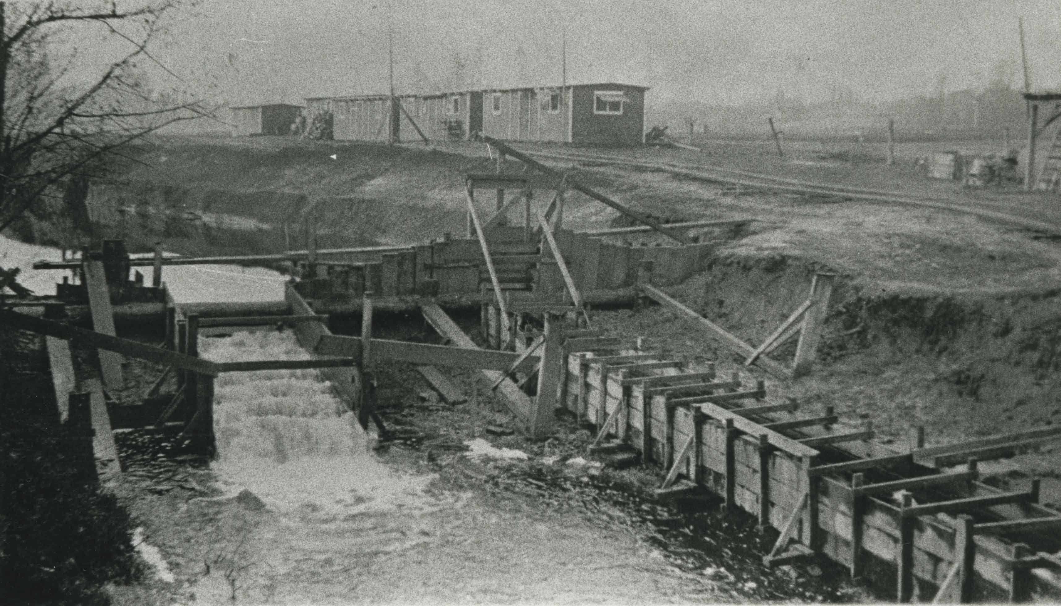
Brunette River dam
https://search.heritageburnaby.ca/link/archivedescription35467
- Repository
- City of Burnaby Archives
- Date
- [1930] (date of original), copied 1986
- Collection/Fonds
- Burnaby Historical Society fonds
- Description Level
- Item
- Physical Description
- 1 photograph : b&w ; 12.7 x 17.8 cm print
- Scope and Content
- Photograph of the Brunette River dam. The Picken family home, "Aintree," is faintly visible in the background, with the mailing address of 2600 Cariboo Road, R.R. 2, New Westminster. The number was later changed to 6825 Cariboo Road, and the mail redirected through Burnaby. The Picken family cons…
- Repository
- City of Burnaby Archives
- Date
- [1930] (date of original), copied 1986
- Collection/Fonds
- Burnaby Historical Society fonds
- Subseries
- Pioneer Tales subseries
- Physical Description
- 1 photograph : b&w ; 12.7 x 17.8 cm print
- Description Level
- Item
- Record No.
- 204-325
- Access Restriction
- No restrictions
- Reproduction Restriction
- No known restrictions
- Accession Number
- BHS1988-03
- Scope and Content
- Photograph of the Brunette River dam. The Picken family home, "Aintree," is faintly visible in the background, with the mailing address of 2600 Cariboo Road, R.R. 2, New Westminster. The number was later changed to 6825 Cariboo Road, and the mail redirected through Burnaby. The Picken family consisted of Stanley B. Picken (dam keeper on the Brunette River), his wife Isabel Picken (nee Ponton) and their children.
- Media Type
- Photograph
- Notes
- Title based on contents of photograph
- Geographic Access
- Cariboo Road
- Street Address
- 6825 Cariboo Road
- Historic Neighbourhood
- Burquitlam (Historic Neighbourhood)
- Planning Study Area
- Burnaby Lake Area
Images
![Brunette River dam, [1930] (date of original), copied 1986 thumbnail](/media/hpo/_Data/_Archives_Images/_Unrestricted/204/204-325.jpg)
![Capilano Dam, [1905] thumbnail](/media/hpo/_Data/_Archives_Images/_Unrestricted/477/477-118.jpg?width=280)
Capilano Dam
https://search.heritageburnaby.ca/link/archivedescription38799
- Repository
- City of Burnaby Archives
- Date
- [1905]
- Collection/Fonds
- Peers Family and Hill Family fonds
- Description Level
- Item
- Physical Description
- 1 photograph : sepia ; 6 x 8 cm on page 11.5 x 14 cm (pasted in album)
- Scope and Content
- Photograph of the Capilano Dam in North Vancouver. In the background can be seen what appears to be the caretaker's cottage.
- Repository
- City of Burnaby Archives
- Date
- [1905]
- Collection/Fonds
- Peers Family and Hill Family fonds
- Physical Description
- 1 photograph : sepia ; 6 x 8 cm on page 11.5 x 14 cm (pasted in album)
- Description Level
- Item
- Record No.
- 477-118
- Access Restriction
- No restrictions
- Reproduction Restriction
- No known restrictions
- Accession Number
- 2007-12
- Scope and Content
- Photograph of the Capilano Dam in North Vancouver. In the background can be seen what appears to be the caretaker's cottage.
- Media Type
- Photograph
- Notes
- Title based on contents of photograph
Images
![Capilano Dam, [1905] thumbnail](/media/hpo/_Data/_Archives_Images/_Unrestricted/477/477-118.jpg)
![Capilano Dam, [1905] thumbnail](/media/hpo/_Data/_Archives_Images/_Unrestricted/477/477-119.jpg?width=280)
Capilano Dam
https://search.heritageburnaby.ca/link/archivedescription38800
- Repository
- City of Burnaby Archives
- Date
- [1905]
- Collection/Fonds
- Peers Family and Hill Family fonds
- Description Level
- Item
- Physical Description
- 1 photograph : b&w ; 6 x 8 cm on page 11.5 x 14 cm (pasted in album)
- Scope and Content
- Photograph of the Capilano Dam in North Vancouver. In the background can be seen what appears to be the caretaker's cottage.
- Repository
- City of Burnaby Archives
- Date
- [1905]
- Collection/Fonds
- Peers Family and Hill Family fonds
- Physical Description
- 1 photograph : b&w ; 6 x 8 cm on page 11.5 x 14 cm (pasted in album)
- Description Level
- Item
- Record No.
- 477-119
- Access Restriction
- No restrictions
- Reproduction Restriction
- No known restrictions
- Accession Number
- 2007-12
- Scope and Content
- Photograph of the Capilano Dam in North Vancouver. In the background can be seen what appears to be the caretaker's cottage.
- Media Type
- Photograph
- Notes
- Title based on contents of photograph
Images
![Capilano Dam, [1905] thumbnail](/media/hpo/_Data/_Archives_Images/_Unrestricted/477/477-119.jpg)
![Cariboo Dam fish weir, [2002] thumbnail](/media/hpo/_Data/_Archives_Images/_Unrestricted/535/535-2996.jpg?width=280)
Cariboo Dam fish weir
https://search.heritageburnaby.ca/link/archivedescription97722
- Repository
- City of Burnaby Archives
- Date
- [2002]
- Collection/Fonds
- Burnaby NewsLeader photograph collection
- Description Level
- Item
- Physical Description
- 1 photograph (tiff) : col.
- Scope and Content
- Photograph of Elmer Rudolph and Bob Henderson helping a salmon through the fish weir at the Cariboo Dam on the Brunette River.
- Repository
- City of Burnaby Archives
- Date
- [2002]
- Collection/Fonds
- Burnaby NewsLeader photograph collection
- Physical Description
- 1 photograph (tiff) : col.
- Description Level
- Item
- Record No.
- 535-2996
- Access Restriction
- No restrictions
- Reproduction Restriction
- No restrictions
- Accession Number
- 2018-12
- Scope and Content
- Photograph of Elmer Rudolph and Bob Henderson helping a salmon through the fish weir at the Cariboo Dam on the Brunette River.
- Media Type
- Photograph
- Photographer
- Bartel, Mario
- Notes
- Title based on caption
- Collected by editorial for use in a November 2002 issue of the Burnaby NewsLeader
- Caption from metadata: "Elmer Rudolph and Bob Henderson help a mature female salmon, weighing about nine pounds, up through the fish weir at the Cariboo dam. The week of heavy rain has finally made conditions favorable for fish to make their journey up the Brunette River from the Fraser, and then on to their spawning beds, and Rudolph is at the dam every day to help them along. On Saturday, in addition to the mature salmon, he also helped four immature males and two 14-inch Cutthroat."
- Geographic Access
- Burnaby Lake
- Brunette River
- Historic Neighbourhood
- Burnaby Lake (Historic Neighbourhood)
- Planning Study Area
- Burnaby Lake Area
Images
![Cariboo Dam fish weir, [2002] thumbnail](/media/hpo/_Data/_Archives_Images/_Unrestricted/535/535-2996.jpg)

Government Docks, New Westminster
https://search.heritageburnaby.ca/link/archivedescription39576
- Repository
- City of Burnaby Archives
- Date
- 1910
- Collection/Fonds
- Peers Family and Hill Family fonds
- Description Level
- Item
- Physical Description
- 1 photograph : b&w ; 7.8 x 10.2 cm on page 21.5 x 28 cm (pasted in album)
- Scope and Content
- Photograph of a boat (the "Vite") pulled up to the Government docks at the foot of 8th Street in New Westminster. Queensborough can be seen in the background. The three men in the boat are unidentified.
- Repository
- City of Burnaby Archives
- Date
- 1910
- Collection/Fonds
- Peers Family and Hill Family fonds
- Physical Description
- 1 photograph : b&w ; 7.8 x 10.2 cm on page 21.5 x 28 cm (pasted in album)
- Description Level
- Item
- Record No.
- 477-895
- Access Restriction
- No restrictions
- Reproduction Restriction
- No known restrictions
- Accession Number
- 2007-12
- Scope and Content
- Photograph of a boat (the "Vite") pulled up to the Government docks at the foot of 8th Street in New Westminster. Queensborough can be seen in the background. The three men in the boat are unidentified.
- Subjects
- Recreational Activities - Boating
- Structures - Piers and Wharves
- Geographic Features - Rivers
- Media Type
- Photograph
- Notes
- Title based on contents of photograph
Images

![Irrigation flume, [1919] thumbnail](/media/hpo/_Data/_BVM_Images/1974/197500330003ba.jpg?width=280)
Irrigation flume
https://search.heritageburnaby.ca/link/museumdescription3478
- Repository
- Burnaby Village Museum
- Date
- [1919]
- Collection/Fonds
- Burnaby Village Museum Photograph collection
- Description Level
- Item
- Physical Description
- 1 photograph : sepia ; 16 x 11 cm, mounted on card ; 23 x 17.5 cm
- Scope and Content
- Photograph of an irrigation flume (or logging flume) believed to be built by Tom Irvine in the interior plateau of British Columbia. The flume is in the middle of construction as the pile driver is visible in the distance pounding in its verticals. As well, the flume's walkway has been started.
- Repository
- Burnaby Village Museum
- Collection/Fonds
- Burnaby Village Museum Photograph collection
- Description Level
- Item
- Physical Description
- 1 photograph : sepia ; 16 x 11 cm, mounted on card ; 23 x 17.5 cm
- Scope and Content
- Photograph of an irrigation flume (or logging flume) believed to be built by Tom Irvine in the interior plateau of British Columbia. The flume is in the middle of construction as the pile driver is visible in the distance pounding in its verticals. As well, the flume's walkway has been started.
- Accession Code
- HV975.33.3ba
- Access Restriction
- No restrictions
- Date
- [1919]
- Media Type
- Photograph
- Scan Resolution
- 600
- Scan Date
- 2/2/2010
- Scale
- 100
- Notes
- Title based on contents of photograph
- Image from personal photograph album of Tom "Tommy" Irvine (HV975.33.3)
Images
![Irrigation flume, [1919] thumbnail](/media/hpo/_Data/_BVM_Images/1974/197500330003ba.jpg)

New Brunette Dam construction
https://search.heritageburnaby.ca/link/archivedescription35462
- Repository
- City of Burnaby Archives
- Date
- 1931 (date of original), copied 1986
- Collection/Fonds
- Burnaby Historical Society fonds
- Description Level
- Item
- Physical Description
- 1 photograph : b&w ; 12.7 x 17.8 cm print
- Scope and Content
- Photograph of the construction of new Brunette River dam.
- Repository
- City of Burnaby Archives
- Date
- 1931 (date of original), copied 1986
- Collection/Fonds
- Burnaby Historical Society fonds
- Subseries
- Pioneer Tales subseries
- Physical Description
- 1 photograph : b&w ; 12.7 x 17.8 cm print
- Description Level
- Item
- Record No.
- 204-320
- Access Restriction
- No restrictions
- Reproduction Restriction
- No known restrictions
- Accession Number
- BHS1988-03
- Scope and Content
- Photograph of the construction of new Brunette River dam.
- Media Type
- Photograph
- Notes
- Title based on contents of photograph
- Historic Neighbourhood
- Burquitlam (Historic Neighbourhood)
- Planning Study Area
- Burnaby Lake Area
Images
![Old Brunette Dam, [1925] (date of original), copied 1986 thumbnail](/media/hpo/_Data/_Archives_Images/_Unrestricted/204/204-324.jpg?width=280)
Old Brunette Dam
https://search.heritageburnaby.ca/link/archivedescription35466
- Repository
- City of Burnaby Archives
- Date
- [1925] (date of original), copied 1986
- Collection/Fonds
- Burnaby Historical Society fonds
- Description Level
- Item
- Physical Description
- 1 photograph : b&w ; 12.7 x 17.8 cm print
- Scope and Content
- Photograph of the old Brunette dam before 1931. Shown on the left, the spillway allowed spawning salmon to wriggle over into spawning grounds in Eagle Creek and Still Creek.
- Repository
- City of Burnaby Archives
- Date
- [1925] (date of original), copied 1986
- Collection/Fonds
- Burnaby Historical Society fonds
- Subseries
- Pioneer Tales subseries
- Physical Description
- 1 photograph : b&w ; 12.7 x 17.8 cm print
- Description Level
- Item
- Record No.
- 204-324
- Access Restriction
- No restrictions
- Reproduction Restriction
- No known restrictions
- Accession Number
- BHS1988-03
- Scope and Content
- Photograph of the old Brunette dam before 1931. Shown on the left, the spillway allowed spawning salmon to wriggle over into spawning grounds in Eagle Creek and Still Creek.
- Media Type
- Photograph
- Notes
- Title based on contents of photograph
- Historic Neighbourhood
- Burquitlam (Historic Neighbourhood)
- Planning Study Area
- Burnaby Lake Area
Images
![Old Brunette Dam, [1925] (date of original), copied 1986 thumbnail](/media/hpo/_Data/_Archives_Images/_Unrestricted/204/204-324.jpg)
![Old Brunette River Dam, [1920] thumbnail](/media/hpo/_Data/_Archives_Images/_Unrestricted/205/232-002.jpg?width=280)
Old Brunette River Dam
https://search.heritageburnaby.ca/link/archivedescription36205
- Repository
- City of Burnaby Archives
- Date
- [1920]
- Collection/Fonds
- Burnaby Historical Society fonds
- Description Level
- Item
- Physical Description
- 1 photograph : b&w ; 8.5 x 12.5 cm print
- Scope and Content
- Photograph of a group of six men and their five dogs at the Old Brunette River Dam. The men are in suits and most are wearing bowler hats. Their dogs look to be English Foxhounds and Poodles.
- Repository
- City of Burnaby Archives
- Date
- [1920]
- Collection/Fonds
- Burnaby Historical Society fonds
- Subseries
- Love family subseries
- Physical Description
- 1 photograph : b&w ; 8.5 x 12.5 cm print
- Description Level
- Item
- Record No.
- 232-002
- Access Restriction
- No restrictions
- Reproduction Restriction
- No known restrictions
- Accession Number
- BHS1989-24
- Scope and Content
- Photograph of a group of six men and their five dogs at the Old Brunette River Dam. The men are in suits and most are wearing bowler hats. Their dogs look to be English Foxhounds and Poodles.
- Media Type
- Photograph
- Notes
- Title based on contents of photograph
- 1 b&w copy negative accompanying
- Geographic Access
- Brunette River
- Historic Neighbourhood
- Burquitlam (Historic Neighbourhood)
- Planning Study Area
- Burnaby Lake Area
Images
![Old Brunette River Dam, [1920] thumbnail](/media/hpo/_Data/_Archives_Images/_Unrestricted/205/232-002.jpg)
![Water flowing from Stave Lake Dam, [c. 1915] thumbnail](/media/hpo/_Data/_BVM_Images/2022/2022_0032_0019_001.jpg?width=280)
Water flowing from Stave Lake Dam
https://search.heritageburnaby.ca/link/museumdescription19302
- Repository
- Burnaby Village Museum
- Date
- [c. 1915]
- Collection/Fonds
- Esther Love Stanley fonds
- Description Level
- Item
- Physical Description
- 1 photograph : b&w ; 10.5 x 8 cm
- Scope and Content
- Photograph of water flowing from Stave Lake Dam into the Stave River in Mission, British Columbia. Shoreline with large rocks in the foreground and barren trees on the hillsides bordering the river.
- Repository
- Burnaby Village Museum
- Collection/Fonds
- Esther Love Stanley fonds
- Description Level
- Item
- Physical Description
- 1 photograph : b&w ; 10.5 x 8 cm
- Scope and Content
- Photograph of water flowing from Stave Lake Dam into the Stave River in Mission, British Columbia. Shoreline with large rocks in the foreground and barren trees on the hillsides bordering the river.
- Accession Code
- BV022.32.19
- Access Restriction
- No restrictions
- Reproduction Restriction
- No known restrictions
- Date
- [c. 1915]
- Media Type
- Photograph
- Scan Resolution
- 600
- Scan Date
- 2023-04-04
- Notes
- Title based on contents of photograph
- Photograph is part of Esther Love Stanley photograph album 1 (BV022.32.1)
Images
![Water flowing from Stave Lake Dam, [c. 1915] thumbnail](/media/hpo/_Data/_BVM_Images/2022/2022_0032_0019_001.jpg)

Alexandra Bridge in British Columbia
https://search.heritageburnaby.ca/link/archivedescription65748
- Repository
- City of Burnaby Archives
- Date
- 1936
- Collection/Fonds
- Burnaby Historical Society fonds
- Description Level
- Item
- Physical Description
- 1 photograph : b&w hand-tinted into col. ; 17.5 x 24.5 cm [sight] matted in frame 24.5 x 32 cm
- Scope and Content
- Photograph of the Alexandra Bridge in British Columbia. The Alexander Bridge crosses the Fraser Canyon, along the Cariboo Highway, two kilometres north of Spuzzum.
- Repository
- City of Burnaby Archives
- Date
- 1936
- Collection/Fonds
- Burnaby Historical Society fonds
- Subseries
- Ettinger family subseries
- Physical Description
- 1 photograph : b&w hand-tinted into col. ; 17.5 x 24.5 cm [sight] matted in frame 24.5 x 32 cm
- Description Level
- Item
- Record No.
- 428-007
- Access Restriction
- No restrictions
- Reproduction Restriction
- No known restrictions
- Accession Number
- BHS2002-03
- Scope and Content
- Photograph of the Alexandra Bridge in British Columbia. The Alexander Bridge crosses the Fraser Canyon, along the Cariboo Highway, two kilometres north of Spuzzum.
- Media Type
- Photograph
- Photographer
- Edmonds Studio
- Notes
- Title based on contents of photograph
- Note on verso of frame reads: "Spuzzum Bridge / Fraser Canyon"
- Note on recto of matte reads: "Edmonds Studio 1936"
Images


Alexandra Bridge in British Columbia
https://search.heritageburnaby.ca/link/archivedescription85920
- Repository
- City of Burnaby Archives
- Date
- 1933
- Collection/Fonds
- Burnaby Historical Society fonds
- Description Level
- Item
- Physical Description
- 1 photograph : sepia ; 5.5 x 10 cm
- Scope and Content
- Photograph of the Alexandra Bridge in British Columbia. The Alexander Bridge crosses the Fraser Canyon, along the Cariboo Highway, two kilometres north of Spuzzum.
- Repository
- City of Burnaby Archives
- Date
- 1933
- Collection/Fonds
- Burnaby Historical Society fonds
- Subseries
- Ettinger family subseries
- Physical Description
- 1 photograph : sepia ; 5.5 x 10 cm
- Description Level
- Item
- Record No.
- 428-008
- Access Restriction
- No restrictions
- Reproduction Restriction
- No known restrictions
- Accession Number
- BHS2002-03
- Scope and Content
- Photograph of the Alexandra Bridge in British Columbia. The Alexander Bridge crosses the Fraser Canyon, along the Cariboo Highway, two kilometres north of Spuzzum.
- Media Type
- Photograph
- Notes
- Title based on contents of photograph
- Note on verso of photograph reads: "Alexander [sic] Bridge / 1933"
Images


Barnet Marine Park
https://search.heritageburnaby.ca/link/archivedescription91581
- Repository
- City of Burnaby Archives
- Date
- August 9, 1996
- Collection/Fonds
- Doreen Lawson fonds
- Description Level
- File
- Physical Description
- 18 photographs : col. slides ; 35 mm
- Scope and Content
- File consists of photographs of Barnet Marine Park, including Barnet Beach pilings, overpass and people preparing kayaks on the shore.
- Repository
- City of Burnaby Archives
- Date
- August 9, 1996
- Collection/Fonds
- Doreen Lawson fonds
- Physical Description
- 18 photographs : col. slides ; 35 mm
- Description Level
- File
- Record No.
- 605-014
- Access Restriction
- No restrictions
- Reproduction Restriction
- No restrictions
- Accession Number
- 2003-30
- Scope and Content
- File consists of photographs of Barnet Marine Park, including Barnet Beach pilings, overpass and people preparing kayaks on the shore.
- Names
- Lawson, Doreen A.
- Media Type
- Photograph
- Photographer
- Lawson, Doreen A.
- Notes
- Title based on contents of photographs
- Note in black in on recto of slide frames of photographs 605-014-1 : 605-014-7, 605-014-9 : 605-014-11, and 605-014-13 reads: "Barnet Beach Pilings"
- Note in black ink on recto of slide frames of photographs 605-014-8 and 605-014-12 reads: "Barnet Beach Kayaks"
- Note in black ink on recto of slide frames of photographs 605-014-14 : 605-014-18 reads: "Barnet Beach Overpass"
- Geographic Access
- Barnet Marine Park
- Historic Neighbourhood
- Barnet (Historic Neighbourhood)
- Planning Study Area
- Burnaby Mountain Area
Images
