More like 'Blacksmith Shop at Oakalla'
Narrow Results By
Subject
- Accidents - Automobile Accidents 10
- Advertising Medium 3
- Advertising Medium - Signs and Signboards 109
- Aerial Photographs 27
- Agricultural Tools and Equipment - Plows 3
- Agriculture 2
- Agriculture - Crops 2
- Agriculture - Farms 51
- Agriculture - Fruit and Berries 6
- Agriculture - Poultry 4
- Animals 1
- Animals - Birds 2
![Oakalla women's cottages, [1950] (date of original), copied 1991 thumbnail](/media/hpo/_Data/_Archives_Images/_Unrestricted/370/370-696.jpg?width=280)
Oakalla women's cottages
https://search.heritageburnaby.ca/link/archivedescription38109
- Repository
- City of Burnaby Archives
- Date
- [1950] (date of original), copied 1991
- Collection/Fonds
- Burnaby Historical Society fonds
- Description Level
- Item
- Physical Description
- 1 photograph : b&w ; 2.9 x 4.2 cm print on contact sheet 20.7 x 26.7 cm
- Scope and Content
- Photograph of the exterior of women's cottages at Oakalla Prison Farm.
- Repository
- City of Burnaby Archives
- Date
- [1950] (date of original), copied 1991
- Collection/Fonds
- Burnaby Historical Society fonds
- Subseries
- Burnaby Image Bank subseries
- Physical Description
- 1 photograph : b&w ; 2.9 x 4.2 cm print on contact sheet 20.7 x 26.7 cm
- Description Level
- Item
- Record No.
- 370-696
- Access Restriction
- No restrictions
- Reproduction Restriction
- No restrictions
- Accession Number
- BHS1999-03
- Scope and Content
- Photograph of the exterior of women's cottages at Oakalla Prison Farm.
- Names
- Oakalla Prison Farm
- Media Type
- Photograph
- Notes
- Title based on contents of photograph
- 1 b&w copy negative accompanying
- Negative has a pink cast
- Geographic Access
- Oakmount Crescent
- Street Address
- 5220 Oakmount Crescent
- Historic Neighbourhood
- Burnaby Lake (Historic Neighbourhood)
- Planning Study Area
- Oakalla Area
Images
![Oakalla women's cottages, [1950] (date of original), copied 1991 thumbnail](/media/hpo/_Data/_Archives_Images/_Unrestricted/370/370-696.jpg)
![Oakalla women's residence, [195-] (date of original), copied 1991 thumbnail](/media/hpo/_Data/_Archives_Images/_Unrestricted/370/370-692.jpg?width=280)
Oakalla women's residence
https://search.heritageburnaby.ca/link/archivedescription38105
- Repository
- City of Burnaby Archives
- Date
- [195-] (date of original), copied 1991
- Collection/Fonds
- Burnaby Historical Society fonds
- Description Level
- Item
- Physical Description
- 1 photograph : b&w ; 2.9 x 4.2 cm print on contact sheet 20.7 x 26.7 cm
- Scope and Content
- Photograph of the exterior of a women's "residence" building at Oakalla Prison.
- Repository
- City of Burnaby Archives
- Date
- [195-] (date of original), copied 1991
- Collection/Fonds
- Burnaby Historical Society fonds
- Subseries
- Burnaby Image Bank subseries
- Physical Description
- 1 photograph : b&w ; 2.9 x 4.2 cm print on contact sheet 20.7 x 26.7 cm
- Description Level
- Item
- Record No.
- 370-692
- Access Restriction
- No restrictions
- Reproduction Restriction
- Reproduce for fair dealing purposes only
- Accession Number
- BHS1999-03
- Scope and Content
- Photograph of the exterior of a women's "residence" building at Oakalla Prison.
- Names
- Oakalla Prison Farm
- Media Type
- Photograph
- Notes
- Title based on contents of photograph
- 1 b&w copy negative accompanying
- Negative has a pink cast
- Geographic Access
- Oakmount Crescent
- Street Address
- 5220 Oakmount Crescent
- Historic Neighbourhood
- Burnaby Lake (Historic Neighbourhood)
- Planning Study Area
- Oakalla Area
Images
![Oakalla women's residence, [195-] (date of original), copied 1991 thumbnail](/media/hpo/_Data/_Archives_Images/_Unrestricted/370/370-692.jpg)
![Overlooking Oakalla and Deer Lake, [1935] (date of original), copied 1992 thumbnail](/media/hpo/_Data/_Archives_Images/_Unrestricted/315/315-448.jpg?width=280)
Overlooking Oakalla and Deer Lake
https://search.heritageburnaby.ca/link/archivedescription36990
- Repository
- City of Burnaby Archives
- Date
- [1935] (date of original), copied 1992
- Collection/Fonds
- Burnaby Historical Society fonds
- Description Level
- Item
- Physical Description
- 1 photograph : b&w ; 8.1 x 12.7 cm print
- Scope and Content
- Photograph taken looking northeast from the Price's property overlooking Oakalla and Deer Lake.
- Repository
- City of Burnaby Archives
- Date
- [1935] (date of original), copied 1992
- Collection/Fonds
- Burnaby Historical Society fonds
- Subseries
- Burnaby Centennial Anthology subseries
- Physical Description
- 1 photograph : b&w ; 8.1 x 12.7 cm print
- Description Level
- Item
- Record No.
- 315-448
- Access Restriction
- No restrictions
- Reproduction Restriction
- No known restrictions
- Accession Number
- BHS1994-04
- Scope and Content
- Photograph taken looking northeast from the Price's property overlooking Oakalla and Deer Lake.
- Media Type
- Photograph
- Notes
- Title based on contents of photograph
- Geographic Access
- Deer Lake
- Historic Neighbourhood
- Burnaby Lake (Historic Neighbourhood)
- Planning Study Area
- Oakalla Area
Images
![Overlooking Oakalla and Deer Lake, [1935] (date of original), copied 1992 thumbnail](/media/hpo/_Data/_Archives_Images/_Unrestricted/315/315-448.jpg)
![Supply Stores at Oakalla, [195-] (date of original), copied 1991 thumbnail](/media/hpo/_Data/_Archives_Images/_Unrestricted/370/370-709.jpg?width=280)
Supply Stores at Oakalla
https://search.heritageburnaby.ca/link/archivedescription38122
- Repository
- City of Burnaby Archives
- Date
- [195-] (date of original), copied 1991
- Collection/Fonds
- Burnaby Historical Society fonds
- Description Level
- Item
- Physical Description
- 1 photograph : b&w ; 2.9 x 4.1 cm print on contact sheet 20.1 x 26.5 cm
- Scope and Content
- Photograph of the exterior of the supply stores buildings at Oakalla Prison Farm. Three trucks are parked outside.
- Repository
- City of Burnaby Archives
- Date
- [195-] (date of original), copied 1991
- Collection/Fonds
- Burnaby Historical Society fonds
- Subseries
- Burnaby Image Bank subseries
- Physical Description
- 1 photograph : b&w ; 2.9 x 4.1 cm print on contact sheet 20.1 x 26.5 cm
- Description Level
- Item
- Record No.
- 370-709
- Access Restriction
- No restrictions
- Reproduction Restriction
- Reproduce for fair dealing purposes only
- Accession Number
- BHS1999-03
- Scope and Content
- Photograph of the exterior of the supply stores buildings at Oakalla Prison Farm. Three trucks are parked outside.
- Names
- Oakalla Prison Farm
- Media Type
- Photograph
- Notes
- Title based on contents of photograph
- 1 b&w copy negative accompanying
- Negative has a pink cast
- Geographic Access
- Oakmount Crescent
- Street Address
- 5220 Oakmount Crescent
- Historic Neighbourhood
- Burnaby Lake (Historic Neighbourhood)
- Planning Study Area
- Oakalla Area
Images
![Supply Stores at Oakalla, [195-] (date of original), copied 1991 thumbnail](/media/hpo/_Data/_Archives_Images/_Unrestricted/370/370-709.jpg)
![Vegetable building at Oakalla, [195-] (date of original), copied 1991 thumbnail](/media/hpo/_Data/_Archives_Images/_Unrestricted/370/370-714.jpg?width=280)
Vegetable building at Oakalla
https://search.heritageburnaby.ca/link/archivedescription38127
- Repository
- City of Burnaby Archives
- Date
- [195-] (date of original), copied 1991
- Collection/Fonds
- Burnaby Historical Society fonds
- Description Level
- Item
- Physical Description
- 1 photograph : b&w ; 3.1 x 4.6 cm print on contact sheet 20.1 x 26.5 cm
- Scope and Content
- Photograph of the exterior of the vegetable building at Oakalla.
- Repository
- City of Burnaby Archives
- Date
- [195-] (date of original), copied 1991
- Collection/Fonds
- Burnaby Historical Society fonds
- Subseries
- Burnaby Image Bank subseries
- Physical Description
- 1 photograph : b&w ; 3.1 x 4.6 cm print on contact sheet 20.1 x 26.5 cm
- Description Level
- Item
- Record No.
- 370-714
- Access Restriction
- No restrictions
- Reproduction Restriction
- Reproduce for fair dealing purposes only
- Accession Number
- BHS1999-03
- Scope and Content
- Photograph of the exterior of the vegetable building at Oakalla.
- Names
- Oakalla Prison Farm
- Media Type
- Photograph
- Notes
- Title based on contents of photograph
- 1 b&w copy negative accompanying
- Negative has a pink cast
- Geographic Access
- Oakmount Crescent
- Street Address
- 5220 Oakmount Crescent
- Historic Neighbourhood
- Burnaby Lake (Historic Neighbourhood)
- Planning Study Area
- Oakalla Area
Images
![Vegetable building at Oakalla, [195-] (date of original), copied 1991 thumbnail](/media/hpo/_Data/_Archives_Images/_Unrestricted/370/370-714.jpg)
Municipal Works Yard
https://search.heritageburnaby.ca/link/archivedescription34588
- Repository
- City of Burnaby Archives
- Date
- 1958
- Collection/Fonds
- Burnaby Historical Society fonds
- Description Level
- Item
- Physical Description
- 1 photograph : b&w ; 18.4 x 23.5 cm
- Scope and Content
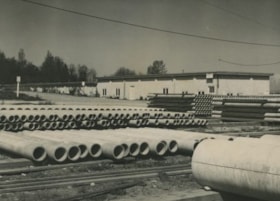
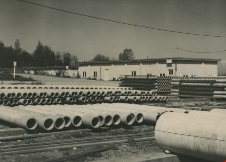
- Photograph of Burnaby Municipal Works Yard with pipes stacked outside and a building in the background.
- Repository
- City of Burnaby Archives
- Date
- 1958
- Collection/Fonds
- Burnaby Historical Society fonds
- Subseries
- Photographs subseries
- Physical Description
- 1 photograph : b&w ; 18.4 x 23.5 cm
- Description Level
- Item
- Record No.
- 062-001
- Access Restriction
- No restrictions
- Reproduction Restriction
- Reproduce for fair dealing purposes only
- Accession Number
- BHS2007-04
- Scope and Content
- Photograph of Burnaby Municipal Works Yard with pipes stacked outside and a building in the background.
- Media Type
- Photograph
- Notes
- Title based on contents of photograph
Images

Opening of the Hastings-Barnet Road
https://search.heritageburnaby.ca/link/archivedescription38660
- Repository
- City of Burnaby Archives
- Date
- 1927
- Collection/Fonds
- Burnaby Historical Society fonds
- Description Level
- Item
- Physical Description
- 1 photograph : sepia ; 17.5 x 26.5 cm
- Scope and Content
- Photograph of the official opening of the newly paved Hastings-Barnet Road which opened on Saturday December 10, 1927. In the foreground the Provincial Minister of Public Works Dr. W.H. Sutherland is opening a wooden gate, with a large crowd gathered around. The Barnet Lumber Company Ltd. building …
- Repository
- City of Burnaby Archives
- Date
- 1927
- Collection/Fonds
- Burnaby Historical Society fonds
- Subseries
- North Burnaby Board of Trade subseries
- Physical Description
- 1 photograph : sepia ; 17.5 x 26.5 cm
- Description Level
- Item
- Record No.
- 476-003
- Access Restriction
- No restrictions
- Reproduction Restriction
- No known restrictions
- Accession Number
- BHS2005-8
- Scope and Content
- Photograph of the official opening of the newly paved Hastings-Barnet Road which opened on Saturday December 10, 1927. In the foreground the Provincial Minister of Public Works Dr. W.H. Sutherland is opening a wooden gate, with a large crowd gathered around. The Barnet Lumber Company Ltd. building on Hastings Street is in the background.
- Subjects
- Geographic Features - Roads
- Persons - Crowds
- Buildings - Industrial - Mills
- Officials - Elected Officials
- Public Services - Public Works
- Names
- Barnet Mill
- Sutherland, W.H.
- Media Type
- Photograph
- Notes
- Title based on contents of photograph
- Geographic Access
- Hastings Street
- Street Address
- 3995 Hastings Street
- Historic Neighbourhood
- Vancouver Heights (Historic Neighbourhood)
- Planning Study Area
- Burnaby Heights Area
Images

Chevron Oil Refinery
https://search.heritageburnaby.ca/link/archivedescription79435
- Repository
- City of Burnaby Archives
- Date
- September 5, 1976
- Collection/Fonds
- Burnaby Public Library Contemporary Visual Archive Project
- Description Level
- Item
- Physical Description
- 1 photograph : b&w ; 11 x 16 cm mounted on cardboard
- Scope and Content
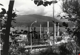
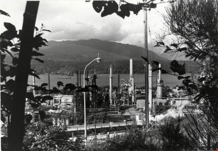
- Photograph shows an aerial view of the Chevron Oil Refinery at the north end of Willingdon Avenue with the North Shore in the background. The photo was taken from the top of Penzance Drive.
- Repository
- City of Burnaby Archives
- Date
- September 5, 1976
- Collection/Fonds
- Burnaby Public Library Contemporary Visual Archive Project
- Physical Description
- 1 photograph : b&w ; 11 x 16 cm mounted on cardboard
- Description Level
- Item
- Record No.
- 556-287
- Access Restriction
- No restrictions
- Reproduction Restriction
- Reproduce for fair dealing purposes only
- Accession Number
- 2013-13
- Scope and Content
- Photograph shows an aerial view of the Chevron Oil Refinery at the north end of Willingdon Avenue with the North Shore in the background. The photo was taken from the top of Penzance Drive.
- Names
- Chevron Corporation
- Media Type
- Photograph
- Notes
- Scope note taken directly from BPL photograph description.
- 1 b&w copy negative : 10 x 12.5 cm accompanying
- Photographers identified by surnames only: Carr and Vardeman
- Geographic Access
- Eton Street
- Street Address
- 4403 Eton Street
- Historic Neighbourhood
- Vancouver Heights (Historic Neighbourhood)
- Planning Study Area
- Burnaby Heights Area
Images
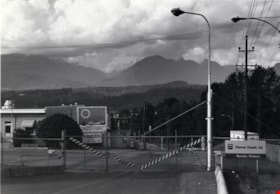
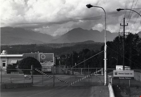
Chevron Oil Refinery
https://search.heritageburnaby.ca/link/archivedescription79436
- Repository
- City of Burnaby Archives
- Date
- September 12, 1976
- Collection/Fonds
- Burnaby Public Library Contemporary Visual Archive Project
- Description Level
- Item
- Physical Description
- 1 photograph : b&w ; 11 x 16 cm mounted on cardboard
- Scope and Content
- Photograph shows the entrance gate to the Chevron Oil Refinery at the north end of Willingdon Avenue, with a view of the North Shore in the background.
- Repository
- City of Burnaby Archives
- Date
- September 12, 1976
- Collection/Fonds
- Burnaby Public Library Contemporary Visual Archive Project
- Physical Description
- 1 photograph : b&w ; 11 x 16 cm mounted on cardboard
- Description Level
- Item
- Record No.
- 556-288
- Access Restriction
- No restrictions
- Reproduction Restriction
- Reproduce for fair dealing purposes only
- Accession Number
- 2013-13
- Scope and Content
- Photograph shows the entrance gate to the Chevron Oil Refinery at the north end of Willingdon Avenue, with a view of the North Shore in the background.
- Names
- Chevron Corporation
- Media Type
- Photograph
- Notes
- Scope note taken directly from BPL photograph description.
- 1 b&w copy negative : 10 x 12.5 cm accompanying
- Photographers identified by surnames only: Carr and Vardeman
- Geographic Access
- Eton Street
- Street Address
- 4403 Eton Street
- Historic Neighbourhood
- Vancouver Heights (Historic Neighbourhood)
- Planning Study Area
- Burnaby Heights Area
Images

Gulf Oil Refinery
https://search.heritageburnaby.ca/link/archivedescription79437
- Repository
- City of Burnaby Archives
- Date
- September 12, 1976
- Collection/Fonds
- Burnaby Public Library Contemporary Visual Archive Project
- Description Level
- Item
- Physical Description
- 1 photograph : b&w ; 11 x 16 cm mounted on cardboard
- Scope and Content
- Photograph shows a truck coming out of the Gulf Oil Refinery on Barnet Road near the boundary of Burnaby and Coquitlam.
- Repository
- City of Burnaby Archives
- Date
- September 12, 1976
- Collection/Fonds
- Burnaby Public Library Contemporary Visual Archive Project
- Physical Description
- 1 photograph : b&w ; 11 x 16 cm mounted on cardboard
- Description Level
- Item
- Record No.
- 556-289
- Access Restriction
- No restrictions
- Reproduction Restriction
- Reproduce for fair dealing purposes only
- Accession Number
- 2013-13
- Scope and Content
- Photograph shows a truck coming out of the Gulf Oil Refinery on Barnet Road near the boundary of Burnaby and Coquitlam.
- Names
- Gulf Oil
- Media Type
- Photograph
- Notes
- Scope note taken directly from BPL photograph description.
- 1 b&w copy negative : 10 x 12.5 cm accompanying
- Photographers identified by surnames only: Carr and Vardeman
- Geographic Access
- Barnet Road
- Planning Study Area
- Burnaby Mountain Area
Images

![Harry Pride and Barnet townsite, [2004] thumbnail](/media/hpo/_Data/_Archives_Images/_Unrestricted/535/535-2056-1.jpg?width=280)
Harry Pride and Barnet townsite
https://search.heritageburnaby.ca/link/archivedescription96386
- Repository
- City of Burnaby Archives
- Date
- [2004]
- Collection/Fonds
- Burnaby NewsLeader photograph collection
- Description Level
- File
- Physical Description
- 3 photographs (tiff) : col.
- Scope and Content
- File contains photographs of Harry Pride at work on researching his book about Burnaby's Barnet townsite. Photographs depict Pride with Beatrice Woolsey-McMillan, a former resident of the community, on the shore of the Burrard Inlet, and Pride viewing historical photographs and one of the remaining…
- Repository
- City of Burnaby Archives
- Date
- [2004]
- Collection/Fonds
- Burnaby NewsLeader photograph collection
- Physical Description
- 3 photographs (tiff) : col.
- Description Level
- File
- Record No.
- 535-2056
- Access Restriction
- No restrictions
- Reproduction Restriction
- No restrictions
- Accession Number
- 2018-12
- Scope and Content
- File contains photographs of Harry Pride at work on researching his book about Burnaby's Barnet townsite. Photographs depict Pride with Beatrice Woolsey-McMillan, a former resident of the community, on the shore of the Burrard Inlet, and Pride viewing historical photographs and one of the remaining structures from the Barnet sawmill.
- Subjects
- Geographic Features - Inlets
- Buildings - Industrial - Saw Mills
- Buildings - Industrial - Mills
- Media Type
- Photograph
- Photographer
- Bartel, Mario
- Notes
- Title based on caption
- Collected by editorial for use in a March 2004 issue of the Burnaby NewsLeader
- Caption from metadata for 535-2056-1: "Harry Pride, who is working on a book about Burnaby's Barnet townsite, reminisces with Beatrice Woolsey-McMillan, who lived in the mill community along the Burrard Inlet from 1925-46."
- Caption from metadata for 535-2056-2: "Harry Pride sorts through some of the historical photos he's collected for a book he's working on about Burnaby's Barnet townsite, along the Burrard Inlet."
- Caption from metadata for 535-2056-3: "Harry Pride, who's working on a book about Burnaby's Barnet townsite, checks out one of the remaining structures from the sawmill that once bustled along the Burrard Inlet."
- Geographic Access
- Barnet Village
- Burrard Inlet
- Barnet Marine Park
- Historic Neighbourhood
- Barnet (Historic Neighbourhood)
- Planning Study Area
- Burnaby Mountain Area
Images
![Harry Pride and Barnet townsite, [2004] thumbnail](/media/hpo/_Data/_Archives_Images/_Unrestricted/535/535-2056-1.jpg)
Southern Railway of BC Burnaby
https://search.heritageburnaby.ca/link/archivedescription94306
- Repository
- City of Burnaby Archives
- Date
- February 1994
- Collection/Fonds
- Grover, Elliott & Co. Ltd. fonds
- Description Level
- File
- Physical Description
- 16 photographs : col. negatives ; 35 mm + 1 computer disk ; 14 x 14 cm
- Scope and Content
- Photographs of properties owned by Scott Paper Ltd, including the Doman Sawmill property. Several of the photographs include zoning signs notifying the public that the property is to be developed or redeveloped for Heavy Industrial permitted use.
- Repository
- City of Burnaby Archives
- Date
- February 1994
- Collection/Fonds
- Grover, Elliott & Co. Ltd. fonds
- Physical Description
- 16 photographs : col. negatives ; 35 mm + 1 computer disk ; 14 x 14 cm
- Description Level
- File
- Record No.
- 622-091
- Access Restriction
- No restrictions
- Reproduction Restriction
- No restrictions
- Accession Number
- 2017-39
- Scope and Content
- Photographs of properties owned by Scott Paper Ltd, including the Doman Sawmill property. Several of the photographs include zoning signs notifying the public that the property is to be developed or redeveloped for Heavy Industrial permitted use.
- Subjects
- Buildings - Industrial
- Buildings - Industrial - Mills
- Advertising Medium - Signs and Signboards
- Media Type
- Photograph
- Photographer
- Young, Richard
- Notes
- Transcribed title
- Title transcribed from envelope photographs were originally housed in
- File no. 94-100-O
- Computer disk labelled "Railands.xsl / 2/93"
3051-75 Underhill Ave
https://search.heritageburnaby.ca/link/archivedescription93744
- Repository
- City of Burnaby Archives
- Date
- 1989
- Collection/Fonds
- Grover, Elliott & Co. Ltd. fonds
- Description Level
- File
- Physical Description
- 11 photographs : col. negatives ; 35 mm
- Scope and Content
- Photographs of two industrial buildings and a residential building in Burnaby, BC.
- Repository
- City of Burnaby Archives
- Date
- 1989
- Collection/Fonds
- Grover, Elliott & Co. Ltd. fonds
- Physical Description
- 11 photographs : col. negatives ; 35 mm
- Description Level
- File
- Record No.
- 622-029
- Access Restriction
- No restrictions
- Reproduction Restriction
- No restrictions
- Accession Number
- 2017-39
- Scope and Content
- Photographs of two industrial buildings and a residential building in Burnaby, BC.
- Media Type
- Photograph
- Notes
- Transcribed title
- Title transcribed from print envelope photographs were originally housed in
- File no. 89-394-B
- Geographic Access
- Underhill Avenue
- Planning Study Area
- Lake City Area
3735-3765 and 3815-3835 First Ave
https://search.heritageburnaby.ca/link/archivedescription93753
- Repository
- City of Burnaby Archives
- Date
- March 25, 1992
- Collection/Fonds
- Grover, Elliott & Co. Ltd. fonds
- Description Level
- File
- Physical Description
- 47 photographs : col. negatives ; 35 mm
- Scope and Content
- Photographs of the commercial-industrial buildings and loading bays located at 3735-3765 and 3815-3835 1st Avenue.
- Repository
- City of Burnaby Archives
- Date
- March 25, 1992
- Collection/Fonds
- Grover, Elliott & Co. Ltd. fonds
- Physical Description
- 47 photographs : col. negatives ; 35 mm
- Description Level
- File
- Record No.
- 622-038
- Access Restriction
- No restrictions
- Reproduction Restriction
- No restrictions
- Accession Number
- 2017-39
- Scope and Content
- Photographs of the commercial-industrial buildings and loading bays located at 3735-3765 and 3815-3835 1st Avenue.
- Subjects
- Buildings - Commercial
- Buildings - Industrial
- Transportation - Trucks
- Transportation - Automobiles
- Media Type
- Photograph
- Photographer
- Young, Richard
- Notes
- Transcribed title
- Title transcribed from envelope photographs were originally housed in
- File no. 92-139-B
- Geographic Access
- 1st Avenue
- Street Address
- 3735 1st Avenue
- 3815 1st Avenue
- Historic Neighbourhood
- Broadview (Historic Neighbourhood)
- Planning Study Area
- West Central Valley Area
5820 S.E. Marine Dr. Burnaby
https://search.heritageburnaby.ca/link/archivedescription94301
- Repository
- City of Burnaby Archives
- Date
- February 1994
- Collection/Fonds
- Grover, Elliott & Co. Ltd. fonds
- Description Level
- File
- Physical Description
- 19 photographs : col. negatives ; 35 mm
- Scope and Content
- Photographs of the commercial property located at 5820 Marine Drive and along the 5800 block of Marine Drive.
- Repository
- City of Burnaby Archives
- Date
- February 1994
- Collection/Fonds
- Grover, Elliott & Co. Ltd. fonds
- Physical Description
- 19 photographs : col. negatives ; 35 mm
- Description Level
- File
- Record No.
- 622-086
- Access Restriction
- No restrictions
- Reproduction Restriction
- No restrictions
- Accession Number
- 2017-39
- Scope and Content
- Photographs of the commercial property located at 5820 Marine Drive and along the 5800 block of Marine Drive.
- Media Type
- Photograph
- Notes
- Transcribed title
- Title transcribed from envelope photographs were originally housed in
- File no. 94-015-B
- Photographer identified as "K.H."
- Geographic Access
- Marine Drive
- Street Address
- 5820 Marine Drive
- Historic Neighbourhood
- Fraser Arm (Historic Neighbourhood)
- Planning Study Area
- Big Bend Area
6622 Willingdon
https://search.heritageburnaby.ca/link/archivedescription93741
- Repository
- City of Burnaby Archives
- Date
- 1989
- Collection/Fonds
- Grover, Elliott & Co. Ltd. fonds
- Description Level
- File
- Physical Description
- 14 photographs : col. negatives ; 35 mm + 3 photographs : col. ; 10 cm x 15 cm
- Scope and Content
- Photographs of the exterior of a three-storey apartment complex located at 6622 Willingdon Avenue, an unidentified industrial complex (Norland), and Heywood Park Place.
- Repository
- City of Burnaby Archives
- Date
- 1989
- Collection/Fonds
- Grover, Elliott & Co. Ltd. fonds
- Physical Description
- 14 photographs : col. negatives ; 35 mm + 3 photographs : col. ; 10 cm x 15 cm
- Description Level
- File
- Record No.
- 622-026
- Access Restriction
- No restrictions
- Reproduction Restriction
- No restrictions
- Accession Number
- 2017-39
- Scope and Content
- Photographs of the exterior of a three-storey apartment complex located at 6622 Willingdon Avenue, an unidentified industrial complex (Norland), and Heywood Park Place.
- Media Type
- Photograph
- Notes
- Transcribed title
- Title transcribed from print envelope photographs were originally housed in
- File no. 89-235-B
- Photographs 622-026-15 : 622-026-17 depict 6622 Willingdon Avenue
- Geographic Access
- Willingdon Avenue
- Street Address
- 6622 Willingdon Avenue
- Historic Neighbourhood
- Central Park (Historic Neighbourhood)
- Planning Study Area
- Maywood Area
8503-8537 Eastlake dr / 2820-2880 Production Way / & 8500-8544 Baxter Place
https://search.heritageburnaby.ca/link/archivedescription93889
- Repository
- City of Burnaby Archives
- Date
- October - November 1993
- Collection/Fonds
- Grover, Elliott & Co. Ltd. fonds
- Description Level
- File
- Physical Description
- 19 photographs : col. negatives ; 35 mm
- Scope and Content
- Photographs of the exteriors of the commercial-industrial buildings located at 8503-8537 Eastlake Drive, 2820-2880 Production Way, and 8500-8544 Baxter Place.
- Repository
- City of Burnaby Archives
- Date
- October - November 1993
- Collection/Fonds
- Grover, Elliott & Co. Ltd. fonds
- Physical Description
- 19 photographs : col. negatives ; 35 mm
- Description Level
- File
- Record No.
- 622-072
- Access Restriction
- No restrictions
- Reproduction Restriction
- No restrictions
- Accession Number
- 2017-39
- Scope and Content
- Photographs of the exteriors of the commercial-industrial buildings located at 8503-8537 Eastlake Drive, 2820-2880 Production Way, and 8500-8544 Baxter Place.
- Media Type
- Photograph
- Notes
- Transcribed title
- Title transcribed from envelope photographs were originally housed in
- File no. 93-178-B
- Photographer identified as "M.G."
- Geographic Access
- Eastlake Drive
- Production Way
- Baxter Place
- Street Address
- 2800 Production Way
- Planning Study Area
- Lake City Area

Esso Filling Station
https://search.heritageburnaby.ca/link/archivedescription34591
- Repository
- City of Burnaby Archives
- Date
- 1958
- Collection/Fonds
- Burnaby Historical Society fonds
- Description Level
- Item
- Physical Description
- 1 photograph : b&w ; 20.2 x 25.4 cm
- Scope and Content
- Photograph of the Esso filling station at Lake City with trucks parked in an industrial area.
- Repository
- City of Burnaby Archives
- Date
- 1958
- Collection/Fonds
- Burnaby Historical Society fonds
- Subseries
- Photographs subseries
- Physical Description
- 1 photograph : b&w ; 20.2 x 25.4 cm
- Description Level
- Item
- Record No.
- 064-001
- Access Restriction
- No restrictions
- Reproduction Restriction
- Reproduce for fair dealing purposes only
- Accession Number
- BHS2007-04
- Scope and Content
- Photograph of the Esso filling station at Lake City with trucks parked in an industrial area.
- Names
- Esso
- Media Type
- Photograph
- Notes
- Title based on contents of photograph
- Planning Study Area
- Lake City Area
Images

![Flower auction and florist's shop, [2003] thumbnail](/media/hpo/_Data/_Archives_Images/_Unrestricted/535/535-1826-1.jpg?width=280)
Flower auction and florist's shop
https://search.heritageburnaby.ca/link/archivedescription96126
- Repository
- City of Burnaby Archives
- Date
- [2003]
- Collection/Fonds
- Burnaby NewsLeader photograph collection
- Description Level
- File
- Physical Description
- 9 photographs (tiff) : col.
- Scope and Content
- File contains photographs of Lucy Lo, a florist at Metro Flowers, during the flower auction at United Flower Growers Co-op on Marine Way and in her shop. Photographs depict the flowers and plants in the warehouse, the bidding theatre and process, and Lo creating floral arrangements.
- Repository
- City of Burnaby Archives
- Date
- [2003]
- Collection/Fonds
- Burnaby NewsLeader photograph collection
- Physical Description
- 9 photographs (tiff) : col.
- Description Level
- File
- Record No.
- 535-1826
- Access Restriction
- No restrictions
- Reproduction Restriction
- No restrictions
- Accession Number
- 2018-12
- Scope and Content
- File contains photographs of Lucy Lo, a florist at Metro Flowers, during the flower auction at United Flower Growers Co-op on Marine Way and in her shop. Photographs depict the flowers and plants in the warehouse, the bidding theatre and process, and Lo creating floral arrangements.
- Media Type
- Photograph
- Photographer
- Bartel, Mario
- Notes
- Title based on caption
- Collected by editorial for use in a January 2003 issue of the Burnaby NewsLeader
- Caption from metadata for 535-1826-1: "Auction day starts early for Burnaby florist, Lucy Lo, as she examines the flowers and plants up for sale at the United Flower Growers Co-op, on Marine Way. That means a walk-around tour of the giant warehouse at 5:30 AM to decide what she'll bid on when the auction begins at six."
- Caption from metadata for 535-1826-2: "Lucy studies the lots in the giant bidding theatre. The flower auction is actually a "Dutch Auction," which means prices start high and go down, with buyers bidding in at the price they're prepared to pay. All the bidding is done by keypad, with transactions recorded and tracked by computer."
- Caption from metadata for 535-1826-3: "Lucy, and her seatmate, Harold Calton, a florist in Richmond, concentrate as they study prices for the day's flowers. The two will sometimes split a lot one of them has bought if it's too large for their own store."
- Caption from metadata for 535-1826-4: "Bids at the auction are placed by a keypad that allows buyers to key in the price they're paying and the quantity of lots they're buying. The transactions are recorded by computer and by the time the auction is over, the buyer's purchases are organized and waiting for pickup in the warehouse."
- Caption from metadata for 535-1826-5: "The auction over, Lucy checks her order in the warehouse."
- Caption from metadata for 535-1826-6: "Lucy wheels part of her day's purchases to her car. Her husband will pick up the rest in his van. The flowers and plants will be on sale in her two stores the same day."
- Caption from metadata for 535-1826-7: "Back in her shop in Metrotown, Lucy creates an arrangement."
- Caption from metadata for 535-1826-8 and 535-1826-9: "Lucy examines a delicate orchid, in her shop, Metro Flowers."
- Geographic Access
- Marine Way
- Kingsway
- Historic Neighbourhood
- Fraser Arm (Historic Neighbourhood)
- Central Park (Historic Neighbourhood)
- Planning Study Area
- Big Bend Area
- Maywood Area
Images
![Flower auction and florist's shop, [2003] thumbnail](/media/hpo/_Data/_Archives_Images/_Unrestricted/535/535-1826-1.jpg)
![Tramline tracks, [1905] thumbnail](/media/hpo/_Data/_BVM_Images/1995/1995_0010_0001_001.jpg?width=280)
Tramline tracks
https://search.heritageburnaby.ca/link/museumdescription3361
- Repository
- Burnaby Village Museum
- Date
- [1905]
- Collection/Fonds
- Burnaby Village Museum Photograph collection
- Description Level
- Item
- Physical Description
- 1 photograph : b&w ; 15 x 25.5 cm print
- Scope and Content
- Photograph of a British Columbia Electric Railway Company tramline track on Sixth Street and Twelfth Avenue. George Leaf's General Store, located at 7745 Sixth Street is visible on the left and Cliff's Car Factory located at 7730 Sixth Street is visible on the right. George Leaf's store burned down…
- Repository
- Burnaby Village Museum
- Collection/Fonds
- Burnaby Village Museum Photograph collection
- Description Level
- Item
- Physical Description
- 1 photograph : b&w ; 15 x 25.5 cm print
- Scope and Content
- Photograph of a British Columbia Electric Railway Company tramline track on Sixth Street and Twelfth Avenue. George Leaf's General Store, located at 7745 Sixth Street is visible on the left and Cliff's Car Factory located at 7730 Sixth Street is visible on the right. George Leaf's store burned down in 1913. The Car factory was established in 1902 and sometime in the 1920s, it became James Brookes Woodworking Plant.
- Subjects
- Transportation - Electric Railroads
- Buildings - Commercial - General Stores
- Buildings - Industrial - Factories
- Geographic Access
- 6th Street
- 12th Avenue
- Street Address
- 7730 6th Street
- 7745 6th Street
- Accession Code
- BV995.10.1
- Access Restriction
- No restrictions
- Reproduction Restriction
- No known restrictions
- Date
- [1905]
- Media Type
- Photograph
- Historic Neighbourhood
- East Burnaby (Historic Neighbourhood)
- Planning Study Area
- Edmonds Area
- Scan Resolution
- 600
- Scan Date
- 07-May-24
- Notes
- Title based on contents of photograph
Images
![Tramline tracks, [1905] thumbnail](/media/hpo/_Data/_BVM_Images/1995/1995_0010_0001_001.jpg)