More like 'Alfred Bingham's writings - Track 3'
Narrow Results By
Subject
- Advertising Medium - Signs and Signboards 1
- Aerial Photographs 4
- Buildings - Commercial - Grocery Stores 1
- Buildings - Residential - Houses 17
- Buildings - Schools 4
- Construction 6
- Construction - Road Construction 7
- Construction Tools and Equipment 3
- Geographic Features - Roads 6
- Industries - Construction 16
- Land Clearing 3
- Occupations - Labourers 2

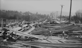
Gilmore Avenue and Douglas Road
https://search.heritageburnaby.ca/link/archivedescription34164
- Repository
- City of Burnaby Archives
- Date
- May 1, 1947
- Collection/Fonds
- Burnaby Historical Society fonds
- Description Level
- Item
- Physical Description
- 1 photograph : b&w negative ; 6.8 x 11.8 cm
- Scope and Content
- Photograph of cleared land at Gilmore Avenue and Douglas Road. Houses under construction can be seen in the background. This is part of the Willingdon Heights subdivision site.
- Repository
- City of Burnaby Archives
- Date
- May 1, 1947
- Collection/Fonds
- Burnaby Historical Society fonds
- Subseries
- Alfred Bingham subseries
- Physical Description
- 1 photograph : b&w negative ; 6.8 x 11.8 cm
- Description Level
- Item
- Record No.
- 010-081
- Access Restriction
- No restrictions
- Reproduction Restriction
- No known restrictions
- Accession Number
- BHS2007-04
- Scope and Content
- Photograph of cleared land at Gilmore Avenue and Douglas Road. Houses under construction can be seen in the background. This is part of the Willingdon Heights subdivision site.
- Subjects
- Industries - Construction
- Buildings - Residential - Houses
- Land Clearing
- Geographic Features - Roads
- Media Type
- Photograph
- Photographer
- Bingham, Alfred "Alf"
- Notes
- Title based on contents of photograph
- Geographic Access
- Gilmore Avenue
- Douglas Road
Images


Gilmore Avenue and Kitchener Street
https://search.heritageburnaby.ca/link/archivedescription34148
- Repository
- City of Burnaby Archives
- Date
- April 20, 1947
- Collection/Fonds
- Burnaby Historical Society fonds
- Description Level
- Item
- Physical Description
- 1 photograph : b&w negative ; 6.8 x 11.4 cm
- Scope and Content
- Photograph of Gilmore Avenue and Kitchener Street with cleared land and the beginning of house construction. This is part of the Willingdon Heights subdivision site.
- Repository
- City of Burnaby Archives
- Date
- April 20, 1947
- Collection/Fonds
- Burnaby Historical Society fonds
- Subseries
- Alfred Bingham subseries
- Physical Description
- 1 photograph : b&w negative ; 6.8 x 11.4 cm
- Description Level
- Item
- Record No.
- 010-064
- Access Restriction
- No restrictions
- Reproduction Restriction
- No known restrictions
- Accession Number
- BHS2007-04
- Scope and Content
- Photograph of Gilmore Avenue and Kitchener Street with cleared land and the beginning of house construction. This is part of the Willingdon Heights subdivision site.
- Media Type
- Photograph
- Photographer
- Bingham, Alfred "Alf"
- Notes
- Title based on contents of photograph
- Geographic Access
- Gilmore Avenue
- Kitchener Street
Images

![Cariboo Cloverleaf, Government Road and Gaglardi Way, [1978] thumbnail](/media/hpo/_Data/_Archives_Images/_Unrestricted/480/480-274.jpg?width=280)
Cariboo Cloverleaf, Government Road and Gaglardi Way
https://search.heritageburnaby.ca/link/archivedescription45379
- Repository
- City of Burnaby Archives
- Date
- [1978]
- Collection/Fonds
- Columbian Newspaper collection
- Description Level
- Item
- Physical Description
- 1 photograph : b&w ; 22.5 x 19 cm
- Scope and Content
- Aerial photograph of the Cariboo Cloverleaf, and the Government Road overpass construction that would join it with Gaglardi Way.
- Repository
- City of Burnaby Archives
- Date
- [1978]
- Collection/Fonds
- Columbian Newspaper collection
- Physical Description
- 1 photograph : b&w ; 22.5 x 19 cm
- Description Level
- Item
- Record No.
- 480-274
- Access Restriction
- No restrictions
- Reproduction Restriction
- No restrictions
- Accession Number
- 2003-02
- Scope and Content
- Aerial photograph of the Cariboo Cloverleaf, and the Government Road overpass construction that would join it with Gaglardi Way.
- Media Type
- Photograph
- Photographer
- King, Basil
- Notes
- Title based on contents of photograph
- Note on recto of photograph reads: "Cariboo cloverleaf in foreground and Government Road overpass construction (centre) will join with Gaglardi Way (top of pic)."
- Geographic Access
- Government Road
- Cariboo Road
- Gaglardi Way
- Historic Neighbourhood
- Burquitlam (Historic Neighbourhood)
- Planning Study Area
- Burnaby Lake Area
- Cariboo-Armstrong Area
- Cameron Area
Images
![Cariboo Cloverleaf, Government Road and Gaglardi Way, [1978] thumbnail](/media/hpo/_Data/_Archives_Images/_Unrestricted/480/480-274.jpg)

Cariboo Road Overpass
https://search.heritageburnaby.ca/link/archivedescription45378
- Repository
- City of Burnaby Archives
- Date
- 1977
- Collection/Fonds
- Columbian Newspaper collection
- Description Level
- Item
- Physical Description
- 1 photograph : b&w ; 12.5 x 24 cm
- Scope and Content
- Photograph of the Cariboo Road Overpass at the begining stage of its construction.
- Repository
- City of Burnaby Archives
- Date
- 1977
- Collection/Fonds
- Columbian Newspaper collection
- Physical Description
- 1 photograph : b&w ; 12.5 x 24 cm
- Description Level
- Item
- Record No.
- 480-273
- Access Restriction
- No restrictions
- Reproduction Restriction
- No restrictions
- Accession Number
- 2003-02
- Scope and Content
- Photograph of the Cariboo Road Overpass at the begining stage of its construction.
- Subjects
- Construction - Road Construction
- Media Type
- Photograph
- Photographer
- Hodge, Craig
- Notes
- Title based on contents of photograph
- Newspaper clipping attached to verso of photograph reads: "Road builders created a sandpile for a giant with the first stage of the $917, 000 Cariboo Rd. overpass in Burnaby. Started several weeks ago the overpass actually consists of two bridges - one crossing railway tracks and Government St., the other spanning the Brunette River - and is expected to be complete early next year."
- Geographic Access
- Cariboo Road
- Trans Canada Highway
- Planning Study Area
- Burnaby Lake Area
Images


Construction of the Caribou Road to freeway link-up
https://search.heritageburnaby.ca/link/archivedescription45363
- Repository
- City of Burnaby Archives
- Date
- September 1977
- Collection/Fonds
- Columbian Newspaper collection
- Description Level
- Item
- Physical Description
- 1 photograph : b&w ; 10.5 x 18.5 cm
- Scope and Content
- Photograph of the construction of the Cariboo Road to 401 Freeway link-up. This was built in an effort to "ease [the] bottleneck of traffic at Stormount [sic] Interchange." The 401 Freeway is now known as the Trans Canada Highway.
- Repository
- City of Burnaby Archives
- Date
- September 1977
- Collection/Fonds
- Columbian Newspaper collection
- Physical Description
- 1 photograph : b&w ; 10.5 x 18.5 cm
- Description Level
- Item
- Record No.
- 480-258
- Access Restriction
- No restrictions
- Reproduction Restriction
- No restrictions
- Accession Number
- 2003-02
- Scope and Content
- Photograph of the construction of the Cariboo Road to 401 Freeway link-up. This was built in an effort to "ease [the] bottleneck of traffic at Stormount [sic] Interchange." The 401 Freeway is now known as the Trans Canada Highway.
- Subjects
- Construction - Road Construction
- Media Type
- Photograph
- Photographer
- Hodge, Craig
- Notes
- Title based on contents of photograph
- Newspaper clipping attached to verso of photograph reads: "Construction is now well underway on the new Caribou Road-freeway link-up which will ease bottleneck of traffic at Stormount [sic] Interchange."
- Geographic Access
- Trans Canada Highway
- Cariboo Road
- Planning Study Area
- Burnaby Lake Area
- Cariboo-Armstrong Area
Images

![Historic photo of Cariboo Road, [190-] date of original, copied [198_] thumbnail](/media/hpo/_Data/_BVM_Images/2020/2020_0005_0860_001.jpg?width=280)
Historic photo of Cariboo Road
https://search.heritageburnaby.ca/link/museumdescription13516
- Repository
- Burnaby Village Museum
- Date
- [190-] date of original, copied [198_]
- Collection/Fonds
- Century Park Museum Association fonds
- Description Level
- Item
- Physical Description
- 1 photograph : b&w print ; 8.7 x 12.5 cm
- Scope and Content
- Photograph of a historic photograph of an unidentified man standing on a boardwalk on the corner of Cariboo Road in Burnaby. Historic photograph includes a label in the top corner that reads: "Cariboo Rd / Burnaby". The road is made of dirt and a two story house is visible across the road from the …
- Repository
- Burnaby Village Museum
- Collection/Fonds
- Century Park Museum Association fonds
- Description Level
- Item
- Physical Description
- 1 photograph : b&w print ; 8.7 x 12.5 cm
- Scope and Content
- Photograph of a historic photograph of an unidentified man standing on a boardwalk on the corner of Cariboo Road in Burnaby. Historic photograph includes a label in the top corner that reads: "Cariboo Rd / Burnaby". The road is made of dirt and a two story house is visible across the road from the man.
- Subjects
- Construction - Road Construction
- Names
- Burnaby Village Museum
- Geographic Access
- Cariboo Road
- Accession Code
- BV020.5.860
- Access Restriction
- No restrictions
- Reproduction Restriction
- May be restricted by third party rights
- Date
- [190-] date of original, copied [198_]
- Media Type
- Photograph
- Scan Resolution
- 600
- Scan Date
- 25-Aug-2020
- Scale
- 100
- Photographer
- Brown, Cice Chandler
- Notes
- Title based on contents of photograph
Images
![Historic photo of Cariboo Road, [190-] date of original, copied [198_] thumbnail](/media/hpo/_Data/_BVM_Images/2020/2020_0005_0860_001.jpg)

Stormont Overpass
https://search.heritageburnaby.ca/link/archivedescription45376
- Repository
- City of Burnaby Archives
- Date
- August 1978
- Collection/Fonds
- Columbian Newspaper collection
- Description Level
- Item
- Physical Description
- 1 photograph : b&w ; 12.5 x 24 cm
- Scope and Content
- Aerial photograph of Stormont Overpass which would provide a direct link from the Trans Canada Highway (previously named the 401 Freeway) to the Lougheed Highway and Simon Fraser University. This was taken when the excavation work was completed, and grading and paving still need to be done.
- Repository
- City of Burnaby Archives
- Date
- August 1978
- Collection/Fonds
- Columbian Newspaper collection
- Physical Description
- 1 photograph : b&w ; 12.5 x 24 cm
- Description Level
- Item
- Record No.
- 480-271
- Access Restriction
- No restrictions
- Reproduction Restriction
- No restrictions
- Accession Number
- 2003-02
- Scope and Content
- Aerial photograph of Stormont Overpass which would provide a direct link from the Trans Canada Highway (previously named the 401 Freeway) to the Lougheed Highway and Simon Fraser University. This was taken when the excavation work was completed, and grading and paving still need to be done.
- Media Type
- Photograph
- Photographer
- Hodge, Craig
- Notes
- Title based on contents of photograph
- Note in pencil on verso of photograph reads: "Altair Aviation / photo by / Craig Hodge"
- Geographic Access
- Cariboo Road
- Gaglardi Way
- Trans Canada Highway
- Historic Neighbourhood
- Burquitlam (Historic Neighbourhood)
- Planning Study Area
- Burnaby Lake Area
- Cameron Area
Images


Stormont Overpass
https://search.heritageburnaby.ca/link/archivedescription45377
- Repository
- City of Burnaby Archives
- Date
- August 1978
- Collection/Fonds
- Columbian Newspaper collection
- Description Level
- Item
- Physical Description
- 1 photograph : b&w ; 16.5 x 24 cm
- Scope and Content
- Aerial photograph of Stormont Overpass which would provide a direct link from the 401 Freeway to the Lougheed Highway and Simon Fraser University. This was taken when the excavation work was completed, and grading and paving still need to be done.
- Repository
- City of Burnaby Archives
- Date
- August 1978
- Collection/Fonds
- Columbian Newspaper collection
- Physical Description
- 1 photograph : b&w ; 16.5 x 24 cm
- Description Level
- Item
- Record No.
- 480-272
- Access Restriction
- No restrictions
- Reproduction Restriction
- No restrictions
- Accession Number
- 2003-02
- Scope and Content
- Aerial photograph of Stormont Overpass which would provide a direct link from the 401 Freeway to the Lougheed Highway and Simon Fraser University. This was taken when the excavation work was completed, and grading and paving still need to be done.
- Media Type
- Photograph
- Photographer
- Hodge, Craig
- Notes
- Title based on contents of photograph
- Newspaper clipping attached to verso of photograph reads: "After six years, work on the Stormont interchange in Burnaby is only a few weeks from completion. The huge clover-leaf junction of Gaglardi Way and the Freeway is on the top left-hand corner, with Gaglardi Way approaching from the bottom right where a bridge has been completed over the Burlington Northern tracks. An embankment linking that bridge with one over the Brunette River awaits only a layer of tarmac, and a path has been cleared through the woods to link up with the clover-leaf. The present access to the Freeway is along the road running from the left to right across the middle of the picture. The interchange will open next month."
- Note in pencil on verso of photograph reads: "Altair Aviation / photo by / Craig Hodge"
- Geographic Access
- Cariboo Road
- Gaglardi Way
- Trans Canada Highway
- Historic Neighbourhood
- Burquitlam (Historic Neighbourhood)
- Planning Study Area
- Burnaby Lake Area
- Cameron Area
Images

![Stormont Overpass, [1978] thumbnail](/media/hpo/_Data/_Archives_Images/_Unrestricted/480/480-275.jpg?width=280)
Stormont Overpass
https://search.heritageburnaby.ca/link/archivedescription45380
- Repository
- City of Burnaby Archives
- Date
- [1978]
- Collection/Fonds
- Columbian Newspaper collection
- Description Level
- Item
- Physical Description
- 1 photograph : b&w ; 16 x 24 cm
- Scope and Content
- Aerial photograph of Stormont Overpass which would provide a direct link from the Trans Canada Highway (previously named the 401 Freeway) to the Lougheed Highway and Simon Fraser University. This was taken when the excavation work was completed, and paving still need to be done.
- Repository
- City of Burnaby Archives
- Date
- [1978]
- Collection/Fonds
- Columbian Newspaper collection
- Physical Description
- 1 photograph : b&w ; 16 x 24 cm
- Description Level
- Item
- Record No.
- 480-275
- Access Restriction
- No restrictions
- Reproduction Restriction
- No restrictions
- Accession Number
- 2003-02
- Scope and Content
- Aerial photograph of Stormont Overpass which would provide a direct link from the Trans Canada Highway (previously named the 401 Freeway) to the Lougheed Highway and Simon Fraser University. This was taken when the excavation work was completed, and paving still need to be done.
- Media Type
- Photograph
- Photographer
- King, Basil
- Notes
- Title based on contents of photograph
- Note on verso of photograph reads: "One of the biggest Highways"
- Geographic Access
- Cariboo Road
- Gaglardi Way
- Trans Canada Highway
- Historic Neighbourhood
- Burquitlam (Historic Neighbourhood)
- Planning Study Area
- Burnaby Lake Area
- Cameron Area
Images
![Stormont Overpass, [1978] thumbnail](/media/hpo/_Data/_Archives_Images/_Unrestricted/480/480-275.jpg)
Gilmore Avenue and Douglas Road
https://search.heritageburnaby.ca/link/archivedescription34162
- Repository
- City of Burnaby Archives
- Date
- April 25, 1947
- Collection/Fonds
- Burnaby Historical Society fonds
- Description Level
- Item
- Physical Description
- 1 photograph : b&w negative ; 6.8 x 11.9 cm
- Scope and Content
- Photograph of cleared land at Gilmore Avenue and Douglas Road. This is part of the Willingdon Heights subdivision site.
- Repository
- City of Burnaby Archives
- Date
- April 25, 1947
- Collection/Fonds
- Burnaby Historical Society fonds
- Subseries
- Alfred Bingham subseries
- Physical Description
- 1 photograph : b&w negative ; 6.8 x 11.9 cm
- Description Level
- Item
- Record No.
- 010-079
- Access Restriction
- No restrictions
- Reproduction Restriction
- No known restrictions
- Accession Number
- BHS2007-04
- Scope and Content
- Photograph of cleared land at Gilmore Avenue and Douglas Road. This is part of the Willingdon Heights subdivision site.
- Subjects
- Land Clearing
- Media Type
- Photograph
- Photographer
- Bingham, Alfred "Alf"
- Notes
- Title based on contents of photograph
- Geographic Access
- Gilmore Avenue
- Douglas Road
Images

Gilmore Avenue and Douglas Road
https://search.heritageburnaby.ca/link/archivedescription34112
- Repository
- City of Burnaby Archives
- Date
- March 27, 1947
- Collection/Fonds
- Burnaby Historical Society fonds
- Description Level
- Item
- Physical Description
- 1 photograph : b&w negative ; 6.8 x 11.6 cm
- Scope and Content
- Photograph of Gilmore Avenue and Douglas Road with a car parked at the side of the road and two men with surveying equipment. This is part of the Willingdon Heights subdivision site.
- Repository
- City of Burnaby Archives
- Date
- March 27, 1947
- Collection/Fonds
- Burnaby Historical Society fonds
- Subseries
- Alfred Bingham subseries
- Physical Description
- 1 photograph : b&w negative ; 6.8 x 11.6 cm
- Description Level
- Item
- Record No.
- 010-028
- Access Restriction
- No restrictions
- Reproduction Restriction
- No known restrictions
- Accession Number
- BHS2007-04
- Scope and Content
- Photograph of Gilmore Avenue and Douglas Road with a car parked at the side of the road and two men with surveying equipment. This is part of the Willingdon Heights subdivision site.
- Subjects
- Industries - Construction
- Buildings - Residential - Houses
- Construction Tools and Equipment
- Media Type
- Photograph
- Photographer
- Bingham, Alfred "Alf"
- Notes
- Title based on contents of photograph
- Geographic Access
- Gilmore Avenue
- Douglas Road
Images


London mixer and contractors
https://search.heritageburnaby.ca/link/archivedescription34138
- Repository
- City of Burnaby Archives
- Date
- April 16, 1947
- Collection/Fonds
- Burnaby Historical Society fonds
- Description Level
- Item
- Physical Description
- 1 photograph : b&w negative ; 6.8 x 11.8 cm
- Scope and Content
- Photograph of Gilmore Avenue and Douglas Road including a London mixer and contractors invovled in house construction. The man standing in the center has been identified as Mr. Marcowitz. This is part of the Willingdon Heights subdivision site.
- Repository
- City of Burnaby Archives
- Date
- April 16, 1947
- Collection/Fonds
- Burnaby Historical Society fonds
- Subseries
- Alfred Bingham subseries
- Physical Description
- 1 photograph : b&w negative ; 6.8 x 11.8 cm
- Description Level
- Item
- Record No.
- 010-054
- Access Restriction
- No restrictions
- Reproduction Restriction
- Reproduce for fair dealing purposes only
- Accession Number
- BHS2007-04
- Scope and Content
- Photograph of Gilmore Avenue and Douglas Road including a London mixer and contractors invovled in house construction. The man standing in the center has been identified as Mr. Marcowitz. This is part of the Willingdon Heights subdivision site.
- Subjects
- Occupations - Labourers
- Industries - Construction
- Construction Tools and Equipment
- Buildings - Residential - Houses
- Media Type
- Photograph
- Photographer
- Bingham, Alfred "Alf"
- Notes
- Title based on contents of photograph
- Geographic Access
- Gilmore Avenue
- Douglas Road
Images

Charles Street and Gilmore Avenue
https://search.heritageburnaby.ca/link/archivedescription34132
- Repository
- City of Burnaby Archives
- Date
- April 2, 1947
- Collection/Fonds
- Burnaby Historical Society fonds
- Description Level
- Item
- Physical Description
- 1 photograph : b&w negative ; 6.8 x 11.6 cm
- Scope and Content
- Photograph of house construction at Charles Street and Gilmore Avenue (north). This is part of the Willingdon Heights subdivision site.
- Repository
- City of Burnaby Archives
- Date
- April 2, 1947
- Collection/Fonds
- Burnaby Historical Society fonds
- Subseries
- Alfred Bingham subseries
- Physical Description
- 1 photograph : b&w negative ; 6.8 x 11.6 cm
- Description Level
- Item
- Record No.
- 010-048-2
- Access Restriction
- No restrictions
- Reproduction Restriction
- No known restrictions
- Accession Number
- BHS2007-04
- Scope and Content
- Photograph of house construction at Charles Street and Gilmore Avenue (north). This is part of the Willingdon Heights subdivision site.
- Media Type
- Photograph
- Photographer
- Bingham, Alfred "Alf"
- Notes
- Title based on contents of photograph
- Geographic Access
- Charles Street
- Gilmore Avenue
Images


Charles Street and Gilmore Avenue
https://search.heritageburnaby.ca/link/archivedescription34176
- Repository
- City of Burnaby Archives
- Date
- May 9, 1947
- Collection/Fonds
- Burnaby Historical Society fonds
- Description Level
- Item
- Physical Description
- 1 photograph : b&w negative ; 6.8 x 11.5 cm
- Scope and Content
- Photograph of the Charles Street and Gilmore Avenue intersection with houses under construction on the right side of the street. This is part of the Willingdon Heights subdivision site.
- Repository
- City of Burnaby Archives
- Date
- May 9, 1947
- Collection/Fonds
- Burnaby Historical Society fonds
- Subseries
- Alfred Bingham subseries
- Physical Description
- 1 photograph : b&w negative ; 6.8 x 11.5 cm
- Description Level
- Item
- Record No.
- 010-093
- Access Restriction
- No restrictions
- Reproduction Restriction
- No known restrictions
- Accession Number
- BHS2007-04
- Scope and Content
- Photograph of the Charles Street and Gilmore Avenue intersection with houses under construction on the right side of the street. This is part of the Willingdon Heights subdivision site.
- Media Type
- Photograph
- Photographer
- Bingham, Alfred "Alf"
- Notes
- Title based on contents of photograph
- Geographic Access
- Charles Street
- Gilmore Avenue
Images

Gilmore Avenue and Charles Street
https://search.heritageburnaby.ca/link/archivedescription34163
- Repository
- City of Burnaby Archives
- Date
- April 25, 1947
- Collection/Fonds
- Burnaby Historical Society fonds
- Description Level
- Item
- Physical Description
- 1 photograph : b&w negative ; 6.8 x 11.3 cm
- Scope and Content
- Photograph of Gilmore Avenue and Charles Street with houses under construction along the right side of the road. This is part of the Willingdon Heights subdivision site.
- Repository
- City of Burnaby Archives
- Date
- April 25, 1947
- Collection/Fonds
- Burnaby Historical Society fonds
- Subseries
- Alfred Bingham subseries
- Physical Description
- 1 photograph : b&w negative ; 6.8 x 11.3 cm
- Description Level
- Item
- Record No.
- 010-080
- Access Restriction
- No restrictions
- Reproduction Restriction
- No known restrictions
- Accession Number
- BHS2007-04
- Scope and Content
- Photograph of Gilmore Avenue and Charles Street with houses under construction along the right side of the road. This is part of the Willingdon Heights subdivision site.
- Media Type
- Photograph
- Photographer
- Bingham, Alfred "Alf"
- Notes
- Title based on contents of photograph
- Geographic Access
- Gilmore Avenue
- Charles Street
Images


Gilmore Avenue and Douglas Road
https://search.heritageburnaby.ca/link/archivedescription34173
- Repository
- City of Burnaby Archives
- Date
- May 9, 1947
- Collection/Fonds
- Burnaby Historical Society fonds
- Description Level
- Item
- Physical Description
- 1 photograph : b&w negative ; 6.8 x 11.6 cm
- Scope and Content
- Photograph of the Gilmore Avenue and Douglas Road intersection with houses under construction on either side of the road, and a bicycle in foreground. This is part of the Willingdon Heights subdivision site.
- Repository
- City of Burnaby Archives
- Date
- May 9, 1947
- Collection/Fonds
- Burnaby Historical Society fonds
- Subseries
- Alfred Bingham subseries
- Physical Description
- 1 photograph : b&w negative ; 6.8 x 11.6 cm
- Description Level
- Item
- Record No.
- 010-090
- Access Restriction
- No restrictions
- Reproduction Restriction
- No known restrictions
- Accession Number
- BHS2007-04
- Scope and Content
- Photograph of the Gilmore Avenue and Douglas Road intersection with houses under construction on either side of the road, and a bicycle in foreground. This is part of the Willingdon Heights subdivision site.
- Subjects
- Transportation - Bicycles
- Industries - Construction
- Buildings - Residential - Houses
- Geographic Features - Roads
- Media Type
- Photograph
- Photographer
- Bingham, Alfred "Alf"
- Notes
- Title based on contents of photograph
- Geographic Access
- Gilmore Avenue
- Douglas Road
Images

Gilmore Avenue at Charles Street
https://search.heritageburnaby.ca/link/archivedescription34160
- Repository
- City of Burnaby Archives
- Date
- April 25, 1947
- Collection/Fonds
- Burnaby Historical Society fonds
- Description Level
- Item
- Physical Description
- 1 photograph : b&w negative ; 6.8 x 11.2 cm
- Scope and Content
- Photograph of Gilmore Avenue just south of Charles Street with a number of houses under construction and piles of lumber. This is part of the Willingdon Heights subdivision site.
- Repository
- City of Burnaby Archives
- Date
- April 25, 1947
- Collection/Fonds
- Burnaby Historical Society fonds
- Subseries
- Alfred Bingham subseries
- Physical Description
- 1 photograph : b&w negative ; 6.8 x 11.2 cm
- Description Level
- Item
- Record No.
- 010-077
- Access Restriction
- No restrictions
- Reproduction Restriction
- No known restrictions
- Accession Number
- BHS2007-04
- Scope and Content
- Photograph of Gilmore Avenue just south of Charles Street with a number of houses under construction and piles of lumber. This is part of the Willingdon Heights subdivision site.
- Media Type
- Photograph
- Photographer
- Bingham, Alfred "Alf"
- Notes
- Title based on contents of photograph
- Geographic Access
- Gilmore Avenue
- Charles Street
Images

![Gilmore Avenue School, [192-?] (date of original), copied 1977 thumbnail](/media/hpo/_Data/_BVM_Images/1977/1977_0099_0011_001.jpg?width=280)
Gilmore Avenue School
https://search.heritageburnaby.ca/link/museumdescription569
- Repository
- Burnaby Village Museum
- Date
- [192-?] (date of original), copied 1977
- Collection/Fonds
- Burnaby Village Museum Photograph collection
- Description Level
- Item
- Physical Description
- 1 photograph : b&w ; 20.2 x 25.2 cm print
- Scope and Content
- Photograph of Gilmore Avenue School, with additions being built. Visible are two cars parked by the school on the right side of the photograph, and construction barricades on one side of the building. An annotation on the back of the photograph reads: "Addition to Gilmore Avenue School / No date."
- Repository
- Burnaby Village Museum
- Collection/Fonds
- Burnaby Village Museum Photograph collection
- Description Level
- Item
- Physical Description
- 1 photograph : b&w ; 20.2 x 25.2 cm print
- Scope and Content
- Photograph of Gilmore Avenue School, with additions being built. Visible are two cars parked by the school on the right side of the photograph, and construction barricades on one side of the building. An annotation on the back of the photograph reads: "Addition to Gilmore Avenue School / No date."
- Subjects
- Buildings - Schools
- Construction
- Names
- Gilmore Avenue School
- Geographic Access
- Gilmore Avenue
- Street Address
- 50 Gilmore Avenue
- Accession Code
- HV977.99.11
- Access Restriction
- No restrictions
- Reproduction Restriction
- May be restricted by third party rights
- Date
- [192-?] (date of original), copied 1977
- Media Type
- Photograph
- Historic Neighbourhood
- Vancouver Heights (Historic Neighbourhood)
- Planning Study Area
- Burnaby Heights Area
- Scan Resolution
- 600
- Scan Date
- 2023-07-11
- Notes
- Title based on contents of photograph
Images
![Gilmore Avenue School, [192-?] (date of original), copied 1977 thumbnail](/media/hpo/_Data/_BVM_Images/1977/1977_0099_0011_001.jpg)
![Gilmore Avenue School construction, [1913] (date of original), copied 1986 thumbnail](/media/hpo/_Data/_Archives_Images/_Unrestricted/204/204-283.jpg?width=280)
Gilmore Avenue School construction
https://search.heritageburnaby.ca/link/archivedescription35425
- Repository
- City of Burnaby Archives
- Date
- [1913] (date of original), copied 1986
- Collection/Fonds
- Burnaby Historical Society fonds
- Description Level
- Item
- Physical Description
- 1 photograph : b&w ; 11.4 x 17.8 cm print
- Scope and Content
- Photograph of the construction of a brick extension to Gilmore Avenue public school. The original Vancouver Heights School building is visible.
- Repository
- City of Burnaby Archives
- Date
- [1913] (date of original), copied 1986
- Collection/Fonds
- Burnaby Historical Society fonds
- Subseries
- Pioneer Tales subseries
- Physical Description
- 1 photograph : b&w ; 11.4 x 17.8 cm print
- Description Level
- Item
- Record No.
- 204-283
- Access Restriction
- No restrictions
- Reproduction Restriction
- No restrictions
- Accession Number
- BHS1988-03
- Scope and Content
- Photograph of the construction of a brick extension to Gilmore Avenue public school. The original Vancouver Heights School building is visible.
- Subjects
- Construction
- Buildings - Schools
- Names
- Gilmore Avenue School
- Media Type
- Photograph
- Photographer
- Eaton, Dr. Carl
- Notes
- Title based on contents of photograph
- Geographic Access
- Gilmore Avenue
- Street Address
- 50 Gilmore Avenue
- Historic Neighbourhood
- Vancouver Heights (Historic Neighbourhood)
- Planning Study Area
- Burnaby Heights Area
Images
![Gilmore Avenue School construction, [1913] (date of original), copied 1986 thumbnail](/media/hpo/_Data/_Archives_Images/_Unrestricted/204/204-283.jpg)
![Gilmore Avenue School construction, [1914] (date of original), copied 1986 thumbnail](/media/hpo/_Data/_Archives_Images/_Unrestricted/204/204-285.jpg?width=280)
Gilmore Avenue School construction
https://search.heritageburnaby.ca/link/archivedescription35427
- Repository
- City of Burnaby Archives
- Date
- [1914] (date of original), copied 1986
- Collection/Fonds
- Burnaby Historical Society fonds
- Description Level
- Item
- Physical Description
- 1 photograph : b&w ; 12.7 x 17.8 cm print
- Scope and Content
- Photograph of Gilmore Avenue Public School extension construction. Note the horse and wagon hauling material to the site. Dr. Carl Eaton was teacher and first principal of Gilmore school (then called Vancouver Heights school).
- Repository
- City of Burnaby Archives
- Date
- [1914] (date of original), copied 1986
- Collection/Fonds
- Burnaby Historical Society fonds
- Subseries
- Pioneer Tales subseries
- Physical Description
- 1 photograph : b&w ; 12.7 x 17.8 cm print
- Description Level
- Item
- Record No.
- 204-285
- Access Restriction
- No restrictions
- Reproduction Restriction
- No restrictions
- Accession Number
- BHS1988-03
- Scope and Content
- Photograph of Gilmore Avenue Public School extension construction. Note the horse and wagon hauling material to the site. Dr. Carl Eaton was teacher and first principal of Gilmore school (then called Vancouver Heights school).
- Names
- Gilmore Avenue School
- Media Type
- Photograph
- Photographer
- Eaton, Dr. Carl
- Notes
- Title based on contents of photograph
- Geographic Access
- Gilmore Avenue
- Street Address
- 50 Gilmore Avenue
- Historic Neighbourhood
- Vancouver Heights (Historic Neighbourhood)
- Planning Study Area
- Burnaby Heights Area
Images
![Gilmore Avenue School construction, [1914] (date of original), copied 1986 thumbnail](/media/hpo/_Data/_Archives_Images/_Unrestricted/204/204-285.jpg)