More like 'Alexandra Bridge in British Columbia'
Narrow Results By
Subject
- Accidents
- Accidents - Automobile Accidents 1
- Advertising Medium - Signs and Signboards 40
- Aerial Photographs 36
- Agricultural Tools and Equipment 2
- Agricultural Tools and Equipment - Gardening Equipment 4
- Agricultural Tools and Equipment - Plows 2
- Agriculture 3
- Agriculture - Farms 12
- Agriculture - Fruit and Berries
- Animals 4
- Animals - Bears 2

Original Second Narrows Bridge collapses
https://search.heritageburnaby.ca/link/museumdescription104
- Repository
- Burnaby Village Museum
- Date
- 1930
- Collection/Fonds
- Burnaby Village Museum Photograph collection
- Description Level
- Item
- Physical Description
- 1 photograph : sepia ; 6 x 10.5 cm
- Scope and Content
- Photograph of the aftermath of the Second Narrows Bridge being hit by the"Losmar" pictured on the right. Soon after being built in 1925, the Second Narrows Bridge was hit countless times by ships at the bascule portion installed at the south end of the bridge (unfortunately installed in a shallow w…
- Repository
- Burnaby Village Museum
- Collection/Fonds
- Burnaby Village Museum Photograph collection
- Description Level
- Item
- Physical Description
- 1 photograph : sepia ; 6 x 10.5 cm
- Scope and Content
- Photograph of the aftermath of the Second Narrows Bridge being hit by the"Losmar" pictured on the right. Soon after being built in 1925, the Second Narrows Bridge was hit countless times by ships at the bascule portion installed at the south end of the bridge (unfortunately installed in a shallow water area to avoid building expensive towers and a lift span). Each time it was hit the bridge was out of commission until it was repaired. The Second Narrows Bridge runs over Burrard Inlet and connects Vancouver to North Vancouver.
- Subjects
- Structures - Bridges
- Accidents
- Accession Code
- BV988.31.6
- Access Restriction
- No restrictions
- Date
- 1930
- Media Type
- Photograph
- Related Material
- For another photograph of the collapse of the Second Narrows Bridge, see BV988.31.7
- Scan Resolution
- 600
- Scan Date
- 2024-04-16
- Notes
- Title based on contents of photograph
- Note in blue pen on verso of photograph reads: "Collapse of original 2nd Narrows Bridge / year?"
Images

![Original Second Narrows Bridge collapses, [between 1925 and 1930] thumbnail](/media/hpo/_Data/_BVM_Images/1988/1988_0031_0007_001.jpg?width=280)
Original Second Narrows Bridge collapses
https://search.heritageburnaby.ca/link/museumdescription105
- Repository
- Burnaby Village Museum
- Date
- [between 1925 and 1930]
- Collection/Fonds
- Burnaby Village Museum Photograph collection
- Description Level
- Item
- Physical Description
- 1 photograph : sepia ; 6 x 10 cm
- Scope and Content
- Photograph of the aftermath of the Second Narrows Bridge being hit by a ship. The span girder is tipped into water on the left side of the photograph and the other girder is broken and in upright position. There is a large ship in the front with letters "CALMAR LINE" written on the side along with …
- Repository
- Burnaby Village Museum
- Collection/Fonds
- Burnaby Village Museum Photograph collection
- Description Level
- Item
- Physical Description
- 1 photograph : sepia ; 6 x 10 cm
- Scope and Content
- Photograph of the aftermath of the Second Narrows Bridge being hit by a ship. The span girder is tipped into water on the left side of the photograph and the other girder is broken and in upright position. There is a large ship in the front with letters "CALMAR LINE" written on the side along with several tug boats. Soon after being built in 1925, the Second Narrows Bridge was hit countless times by ships at the bascule portion installed at the south end of the bridge (unfortunately installed in a shallow water area to avoid building expensive towers and a lift span). Each time it was hit the bridge was out of commission until it was repaired. The Second Narrows Bridge runs over Burrard Inlet and connects Vancouver to North Vancouver.
- Subjects
- Structures - Bridges
- Accidents
- Accession Code
- BV988.31.7
- Access Restriction
- No restrictions
- Date
- [between 1925 and 1930]
- Media Type
- Photograph
- Related Material
- For another photograph of the collapse of the Second Narrows Bridge, see BV988.31.6
- Scan Resolution
- 600
- Scan Date
- 2024-04-16
- Notes
- Title based on contents of photograph
- Note in blue pen on verso of photograph reads: "Collapse of original 2nd Narrows Bridge / year?"
Images
![Original Second Narrows Bridge collapses, [between 1925 and 1930] thumbnail](/media/hpo/_Data/_BVM_Images/1988/1988_0031_0007_001.jpg)
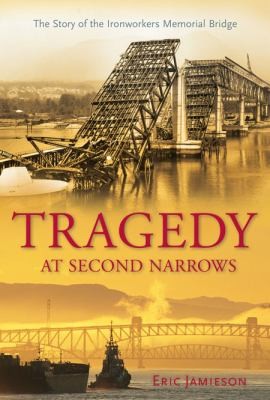
Tragedy at Second Narrows : the story of the Ironworkers Memorial Bridge
https://search.heritageburnaby.ca/link/museumlibrary1384
- Repository
- Burnaby Village Museum
- Author
- Jamieson, Eric, 1949-
- Publication Date
- c2008
- Call Number
- 624.2 JAM
- Repository
- Burnaby Village Museum
- Collection
- Reference Collection
- Material Type
- Book
- ISBN
- 9781550174519
- Call Number
- 624.2 JAM
- Author
- Jamieson, Eric, 1949-
- Place of Publication
- Maderia Park, BC
- Publisher
- Harbour
- Publication Date
- c2008
- Physical Description
- 301 p. : ill.
- Inscription
- "E.J.", Initials in black ink on subtitle page
- Library Subject (LOC)
- Bridges
- Subjects
- Structures - Bridges
- Accidents
- Geographic Access
- Vancouver
- Notes
- Includes bibliographical references and index
- Signed by author
Interview with Reidun Seim by Kathy Bossort January 13, 2016 - Track 5
https://search.heritageburnaby.ca/link/oralhistory654
- Repository
- City of Burnaby Archives
- Date Range
- 1930-1950
- Length
- 0:09:51
- Summary
- This portion of the interview is about Reidun Seim talking about the families and the vineyard and apple orchard on Aubrey Street. She tells stories about picking wild blackberries near Aubrey and raspberries grown on her parent’s farm, and about her mother’s large garden and kale grown for chicken…
- Repository
- City of Burnaby Archives
- Summary
- This portion of the interview is about Reidun Seim talking about the families and the vineyard and apple orchard on Aubrey Street. She tells stories about picking wild blackberries near Aubrey and raspberries grown on her parent’s farm, and about her mother’s large garden and kale grown for chicken feed.
- Date Range
- 1930-1950
- Length
- 0:09:51
- Subjects
- Geographic Features - Neighbourhoods
- Geographic Features - Gardens
- Agriculture - Fruit and Berries
- Geographic Access
- Aubrey Street
- Historic Neighbourhood
- Lochdale (Historic Neighbourhood)
- Planning Study Area
- Lochdale Area
- Interviewer
- Bossort, Kathy
- Interview Date
- January 13, 2016
- Scope and Content
- Recording is of an interview with Reidun Seim conducted by Kathy Bossort. Reidun Seim was one of 23 participants interviewed as part of the Community Heritage Commission’s Burnaby Mountain Oral History Project. The interview is mainly about Reidun Seim’s memories about her parent’s farm on Curtis Street, events in her childhood, and the people who lived in or visited her neighborhood. She takes us on a tour of her neighborhood in the 1940s, telling us stories about families who lived on Curtis Street on and east of 7300 block, including people who lived on Burnaby Mountain in the old Hastings Grove subdivision above the end of municipal water service at Philips Avenue. She describes changes to Curtis Street, particularly after it provided access to Simon Fraser University in 1965. She also talks about her teaching career, and about how she values the green space and conservation area on Burnaby Mountain.
- Biographical Notes
- Reidun Seim was born in 1931 in Vancouver B.C. to Sjur and Martine Seim. Sjur and Martine Seim emigrated to Canada from Norway in 1930, and after settling in Vancouver, moved to an acre of land and a new home at the base of Burnaby Mountain in 1932. Sjur attended UBC to learn about poultry farming and began his own chicken and egg business in 1935. The farm animals and large garden also contributed to the family’s livelihood and self-sufficiency. The Curtis Street neighborhood was a lively place and extended well up Curtis Street on the west slope of Burnaby Mountain, where Reidun would babysit for families. Reidun attended Sperling Avenue Elementary School (Gr. 1-8), Burnaby North High School, and Vancouver Normal School for teacher training in 1950-1951. She began teaching primary grades in Port Coquitlam at James Park School. Most of her career was spent in North Delta, teaching at Kennedy and Annieville schools from 1954-1958, appointed Primary Consultant (1958-1960) and Primary Supervisor (1960-1985), before retiring in 1986. Reidun lived at home with her parents on Curtis Street, commuting to Delta, and continues to live in the original farmhouse.
- Total Tracks
- 14
- Total Length
- 2:35:58
- Interviewee Name
- Seim, Reidun
- Interview Location
- Burnaby City Hall in the Law Library
- Interviewer Bio
- Kathy Bossort is a retired archivist living in Ladner, BC. She worked at the Delta Museum and Archives after graduating from SLAIS (UBC) in 2001 with Masters degrees in library science and archival studies. Kathy grew up in Calgary, Alberta, and, prior to this career change, she lived in the West Kootenays, earning her living as a cook for BC tourist lodges and work camps. She continues to be interested in oral histories as a way to fill the gaps in the written record and bring richer meaning to history.
- Collection/Fonds
- Community Heritage Commission Special Projects fonds
- Media Type
- Sound Recording
Audio Tracks
Track five of interview with Reidun Seim
Track five of interview with Reidun Seim
https://search.heritageburnaby.ca/media/hpo/_Data/_Archives_Oral_Histories/_Unrestricted/MSS196-017/MSS196-017_Track_5.mp3![Frank and Bill Price eating raspberries, [192-] (date of original), copied 1992 thumbnail](/media/hpo/_Data/_Archives_Images/_Unrestricted/315/315-447.jpg?width=280)
Frank and Bill Price eating raspberries
https://search.heritageburnaby.ca/link/archivedescription36989
- Repository
- City of Burnaby Archives
- Date
- [192-] (date of original), copied 1992
- Collection/Fonds
- Burnaby Historical Society fonds
- Description Level
- Item
- Physical Description
- 1 photograph : b&w ; 5.8 x 8.2 cm print
- Scope and Content
- Photograph of father and son, Frank and William "Bill" Price, eating raspberries while picking them at their family property on Royal Oak Avenue at Oakland Street, in the area north of Kingsway.
- Repository
- City of Burnaby Archives
- Date
- [192-] (date of original), copied 1992
- Collection/Fonds
- Burnaby Historical Society fonds
- Subseries
- Burnaby Centennial Anthology subseries
- Physical Description
- 1 photograph : b&w ; 5.8 x 8.2 cm print
- Description Level
- Item
- Record No.
- 315-447
- Access Restriction
- No restrictions
- Reproduction Restriction
- No known restrictions
- Accession Number
- BHS1994-04
- Scope and Content
- Photograph of father and son, Frank and William "Bill" Price, eating raspberries while picking them at their family property on Royal Oak Avenue at Oakland Street, in the area north of Kingsway.
- Media Type
- Photograph
- Notes
- Title based on contents of photograph
- Geographic Access
- Royal Oak Avenue
- Oakland Street
- Historic Neighbourhood
- Central Park (Historic Neighbourhood)
- Planning Study Area
- Marlborough Area
Images
![Frank and Bill Price eating raspberries, [192-] (date of original), copied 1992 thumbnail](/media/hpo/_Data/_Archives_Images/_Unrestricted/315/315-447.jpg)

Roof Collapse at Metrotown Save-on-Foods
https://search.heritageburnaby.ca/link/museumdescription1166
- Repository
- Burnaby Village Museum
- Date
- April 1988
- Collection/Fonds
- Burnaby Village Museum Photograph collection
- Description Level
- Item
- Physical Description
- 1 photograph : col. 19.5 x 24.5 cm
- Scope and Content
- Aerial photograph of the aftermath of the Save-on-Foods roof collapse at Metrotown on April 23, 1988. The rooftop parking lot has caved into the store along with the cars parked in that section. Workmen and police officers in uniforms are at the parking lot.
- Repository
- Burnaby Village Museum
- Collection/Fonds
- Burnaby Village Museum Photograph collection
- Description Level
- Item
- Physical Description
- 1 photograph : col. 19.5 x 24.5 cm
- Scope and Content
- Aerial photograph of the aftermath of the Save-on-Foods roof collapse at Metrotown on April 23, 1988. The rooftop parking lot has caved into the store along with the cars parked in that section. Workmen and police officers in uniforms are at the parking lot.
- Geographic Access
- Kingsway
- Street Address
- 4800 Kingsway
- Accession Code
- BV992.51.1
- Access Restriction
- Restricted access
- Reproduction Restriction
- May be restricted by third party rights
- Date
- April 1988
- Media Type
- Photograph
- Historic Neighbourhood
- Central Park (Historic Neighbourhood)
- Planning Study Area
- Maywood Area
- Scan Resolution
- 600
- Scan Date
- 01-Jun-09
- Scale
- 100
- Photographer
- Hodge, Craig
- Notes
- Title based on contents of photograph
Images
