Narrow Results By
Subject
- Accidents 1
- Advertising Medium - Signs and Signboards
- Aerial Photographs 2
- Agriculture - Farms 1
- Arts 1
- Arts - Paintings 2
- Buildings 2
- Buildings - Agricultural - Greenhouses 1
- Buildings - Agricultural - Nurseries 2
- Buildings - Civic - City Halls
- Buildings - Civic - Seniors Centres 2
- Buildings - Commercial
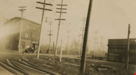
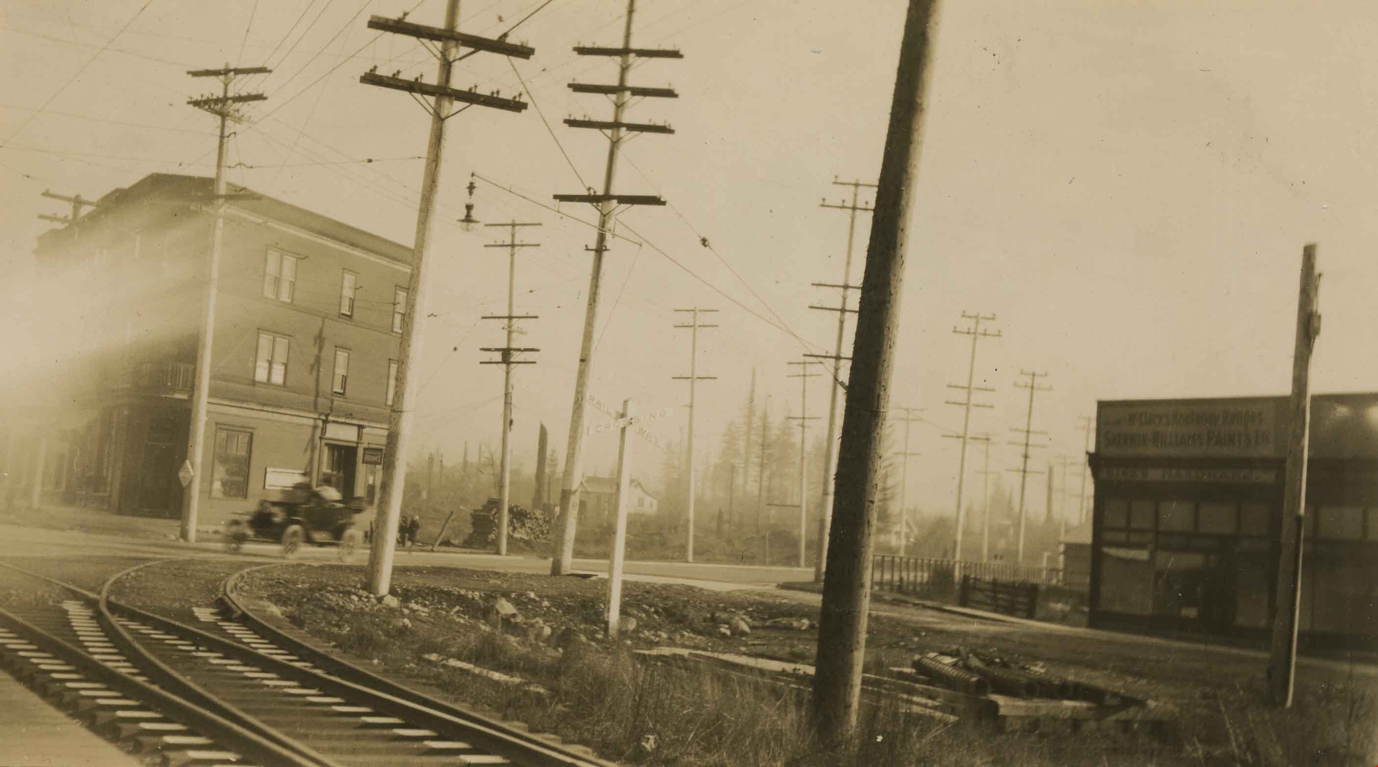
Edmonds and Kingsway
https://search.heritageburnaby.ca/link/archivedescription36162
- Repository
- City of Burnaby Archives
- Date
- 1913
- Collection/Fonds
- Burnaby Historical Society fonds
- Description Level
- Item
- Physical Description
- 1 photograph : sepia ; 7 x 12 cm
- Scope and Content
- Photograph of the railway junction and hydro poles at Edmonds and Kingsway, and the "triangle block" on the far right. A touring car is visible moving though the backgound.
- Repository
- City of Burnaby Archives
- Date
- 1913
- Collection/Fonds
- Burnaby Historical Society fonds
- Physical Description
- 1 photograph : sepia ; 7 x 12 cm
- Description Level
- Item
- Record No.
- 230-007
- Access Restriction
- No restrictions
- Reproduction Restriction
- No known restrictions
- Accession Number
- BHS1989-22
- Scope and Content
- Photograph of the railway junction and hydro poles at Edmonds and Kingsway, and the "triangle block" on the far right. A touring car is visible moving though the backgound.
- Media Type
- Photograph
- Notes
- Title based on contents of photograph
- Geographic Access
- Edmonds Street
- Kingsway
- Historic Neighbourhood
- Edmonds (Historic Neighbourhood)
- Planning Study Area
- Edmonds Area
Images
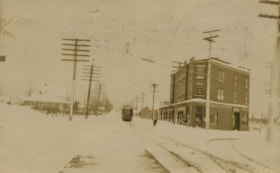
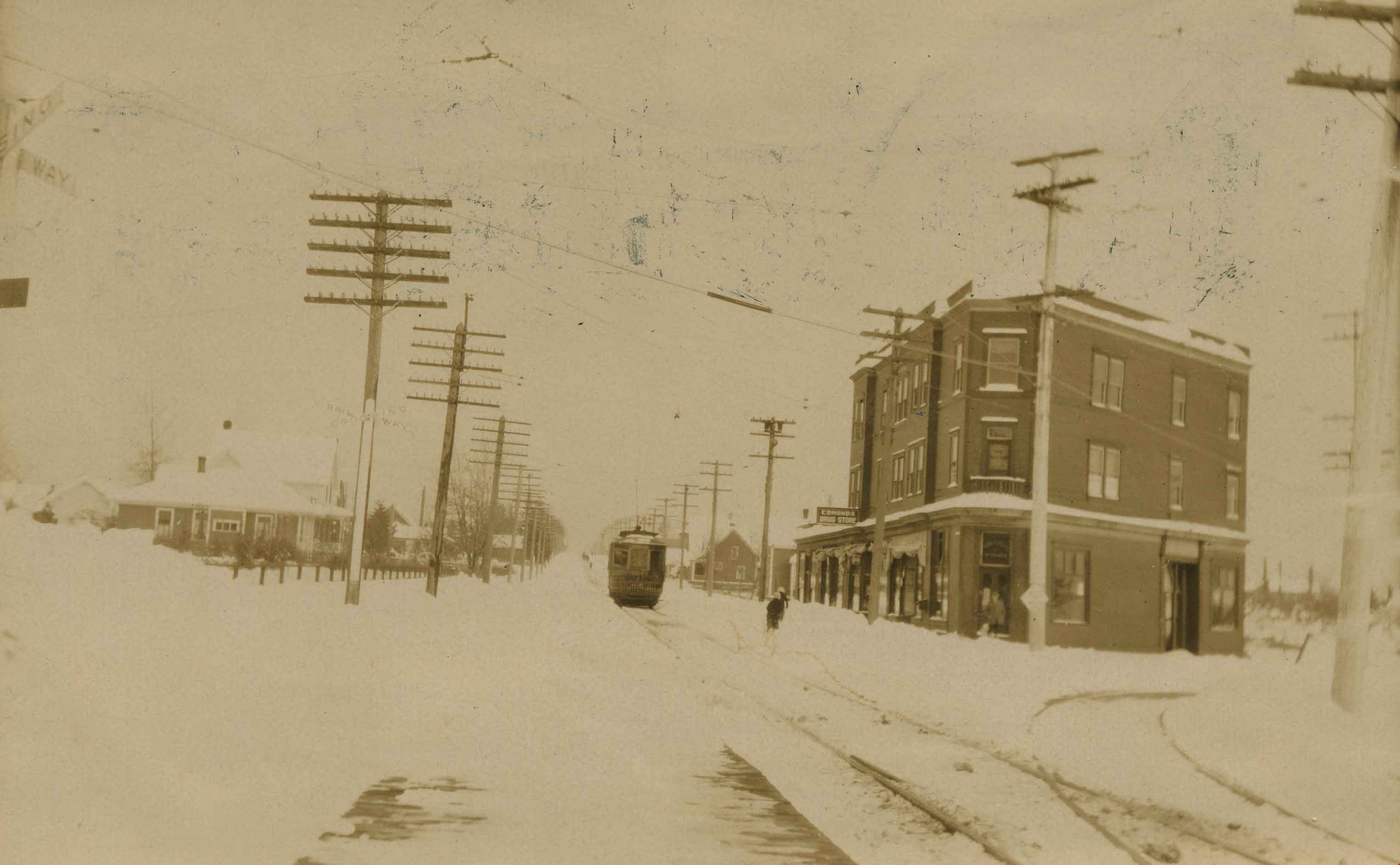
Edmonds and Kingsway tramline
https://search.heritageburnaby.ca/link/archivedescription36163
- Repository
- City of Burnaby Archives
- Date
- 1913
- Collection/Fonds
- Burnaby Historical Society fonds
- Description Level
- Item
- Physical Description
- 1 photograph : sepia ; 8 x 13 cm
- Scope and Content
- Photograph of the railway junction and hydro poles at Edmonds and Kingsway, with the "triangle block" on the left. A tram is visible moving along the snow covered line to New Westminister, via East Burnaby.
- Repository
- City of Burnaby Archives
- Date
- 1913
- Collection/Fonds
- Burnaby Historical Society fonds
- Physical Description
- 1 photograph : sepia ; 8 x 13 cm
- Description Level
- Item
- Record No.
- 230-008
- Access Restriction
- No restrictions
- Reproduction Restriction
- No known restrictions
- Accession Number
- BHS1989-22
- Scope and Content
- Photograph of the railway junction and hydro poles at Edmonds and Kingsway, with the "triangle block" on the left. A tram is visible moving along the snow covered line to New Westminister, via East Burnaby.
- Media Type
- Photograph
- Notes
- Title based on contents of photograph
- Geographic Access
- Edmonds Street
- Kingsway
- Historic Neighbourhood
- Edmonds (Historic Neighbourhood)
- Planning Study Area
- Edmonds Area
Images
![Hotel Burnaby, [1958] thumbnail](/media/hpo/_Data/_Archives_Images/_Unrestricted/001/105-001.jpg?width=280)
Hotel Burnaby
https://search.heritageburnaby.ca/link/archivedescription34700
- Repository
- City of Burnaby Archives
- Date
- [1958]
- Collection/Fonds
- Burnaby Historical Society fonds
- Description Level
- Item
- Physical Description
- 1 photograph : b&w ; 20.3 x 25.2 cm
- Scope and Content
- Photograph of Hotel Burnaby at 1385 Kingsway (later renumbered 7610 Kingsway). An electric "Hotel Burnaby / Vacancy / Parking" sign can be seen on the right. A diner can be seen on the left side of the building with signs reading, "Dining Room," "Diner," "Soda Fountain," "Breakfasts, Lunches, Din…
- Repository
- City of Burnaby Archives
- Date
- [1958]
- Collection/Fonds
- Burnaby Historical Society fonds
- Subseries
- Photographs subseries
- Physical Description
- 1 photograph : b&w ; 20.3 x 25.2 cm
- Description Level
- Item
- Record No.
- 105-001
- Access Restriction
- No restrictions
- Reproduction Restriction
- Reproduce for fair dealing purposes only
- Accession Number
- BHS2007-04
- Scope and Content
- Photograph of Hotel Burnaby at 1385 Kingsway (later renumbered 7610 Kingsway). An electric "Hotel Burnaby / Vacancy / Parking" sign can be seen on the right. A diner can be seen on the left side of the building with signs reading, "Dining Room," "Diner," "Soda Fountain," "Breakfasts, Lunches, Dinners," "Coffee Bar," and "Licensed Premises." Coca-Cola advertisements are also visible. There are entrances to the building with signs above them readings, "Lobby," "Men," and "Ladies and Escorts."
- Subjects
- Advertising Medium - Signs and Signboards
- Buildings - Commercial - Hotels and Motels
- Buildings - Commercial - Restaurants
- Names
- Hotel Burnaby Limited
- Media Type
- Photograph
- Photographer
- Croton Studio Limited
- Notes
- Title based on contents of photograph
- Stamp on back of photograph reads, "Croton Studio / New Westminster BC"
- Geographic Access
- Kingsway
- Street Address
- 7610 Kingsway
- Historic Neighbourhood
- Edmonds (Historic Neighbourhood)
- Planning Study Area
- Edmonds Area
Images
![Hotel Burnaby, [1958] thumbnail](/media/hpo/_Data/_Archives_Images/_Unrestricted/001/105-001.jpg)

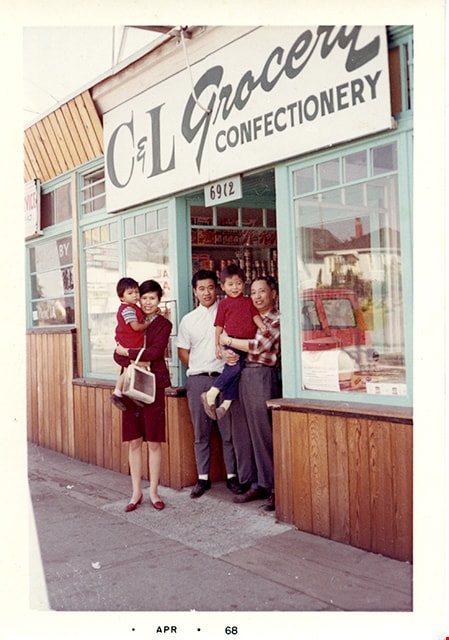
Members of Lee family in front of C&L Grocery Confectionery
https://search.heritageburnaby.ca/link/museumdescription16719
- Repository
- Burnaby Village Museum
- Date
- April 1968
- Collection/Fonds
- Quon Lip Lee fonds
- Description Level
- Item
- Physical Description
- 1 photograph (tiff)
- Scope and Content
- Photograph of Quon Lip Lee (right) and his eldest son, Gary Lee (centre) standing together with his niece and her children in front of the Lee family corner store, C&L Grocery & Confectionery. The store is located at 6912 Kingsway (corner of Kingsway and Griffiths) and was owned by Quon Lip Lee.
- Repository
- Burnaby Village Museum
- Collection/Fonds
- Quon Lip Lee fonds
- Description Level
- Item
- Physical Description
- 1 photograph (tiff)
- Scope and Content
- Photograph of Quon Lip Lee (right) and his eldest son, Gary Lee (centre) standing together with his niece and her children in front of the Lee family corner store, C&L Grocery & Confectionery. The store is located at 6912 Kingsway (corner of Kingsway and Griffiths) and was owned by Quon Lip Lee.
- Geographic Access
- Kingsway
- Street Address
- 6912 Kingsway
- Accession Code
- BV021.18.3
- Access Restriction
- No restrictions
- Reproduction Restriction
- May be restricted by third party rights
- Date
- April 1968
- Media Type
- Photograph
- Historic Neighbourhood
- Edmonds (Historic Neighbourhood)
- Planning Study Area
- Edmonds Area
- Scan Resolution
- 600
- Scan Date
- April 8, 2021
- Scale
- 100
- Notes
- Title based on contents of photograph
- Date stamp on bottom recto of photograph reads: "APR_68"
Images
![Municipal Hall, Edmonds, [1918] thumbnail](/media/hpo/_Data/_Archives_Images/_Unrestricted/001/019-001.jpg?width=280)
Municipal Hall, Edmonds
https://search.heritageburnaby.ca/link/archivedescription34293
- Repository
- City of Burnaby Archives
- Date
- [1918]
- Collection/Fonds
- Burnaby Historical Society fonds
- Description Level
- Item
- Physical Description
- 1 photograph : sepia postcard ; 8.6 x 13.8 cm
- Scope and Content
- Photographic postcard of the exterior of Burnaby's Municipal Hall at Edmonds Street and Kingsway. This was the second Municipal Hall built. Annotation at bottom of photograph reads, "Municipal Hall, Edmonds / Hurndall Photo"
- Repository
- City of Burnaby Archives
- Date
- [1918]
- Collection/Fonds
- Burnaby Historical Society fonds
- Subseries
- Photographs subseries
- Physical Description
- 1 photograph : sepia postcard ; 8.6 x 13.8 cm
- Description Level
- Item
- Record No.
- 019-001
- Access Restriction
- No restrictions
- Reproduction Restriction
- No known restrictions
- Accession Number
- BHS2007-04
- Scope and Content
- Photographic postcard of the exterior of Burnaby's Municipal Hall at Edmonds Street and Kingsway. This was the second Municipal Hall built. Annotation at bottom of photograph reads, "Municipal Hall, Edmonds / Hurndall Photo"
- Names
- Burnaby City Hall
- Media Type
- Photograph
- Photographer
- Hurndall, F.
- Notes
- Title based on contents of photograph
- Geographic Access
- Kingsway
- Street Address
- 7282 Kingsway
- Historic Neighbourhood
- Edmonds (Historic Neighbourhood)
- Planning Study Area
- Edmonds Area
Images
![Municipal Hall, Edmonds, [1918] thumbnail](/media/hpo/_Data/_Archives_Images/_Unrestricted/001/019-001.jpg)

Oh! Zhhu Sam
https://search.heritageburnaby.ca/link/archivedescription98681
- Repository
- City of Burnaby Archives
- Date
- 2022
- Collection/Fonds
- Disappearing Burnaby collection
- Description Level
- Item
- Physical Description
- 1 photograph (jpeg) : col.
- Scope and Content
- Photograph of the 7500 block of Edmonds Street at dusk. The photograph is taken from across Edmonds Street and depicts two commercial buildings: Oh! Zzhu Sam Korean Restaurant and the European Butcher Boy Delicatessen & Grocery. Oh! Zzhu Sam, located at 7506 Edmonds Street, was constructed in 1976.…
- Repository
- City of Burnaby Archives
- Date
- 2022
- Collection/Fonds
- Disappearing Burnaby collection
- Physical Description
- 1 photograph (jpeg) : col.
- Description Level
- Item
- Record No.
- 634-028
- Access Restriction
- No restrictions
- Reproduction Restriction
- No restrictions
- Accession Number
- 2022-14
- Scope and Content
- Photograph of the 7500 block of Edmonds Street at dusk. The photograph is taken from across Edmonds Street and depicts two commercial buildings: Oh! Zzhu Sam Korean Restaurant and the European Butcher Boy Delicatessen & Grocery. Oh! Zzhu Sam, located at 7506 Edmonds Street, was constructed in 1976. Residential houses border the restaurant and grocery store, and a bus shelter, municipal garbage can, and the restaurant's illuminated neon sign stand in front of the buildings.
- Subjects
- Buildings - Commercial
- Buildings - Commercial - Grocery Stores
- Buildings - Commercial - Restaurants
- Media Type
- Photograph
- Photographer
- Cheung, Nakita
- Notes
- Title taken from the associated blog post
- Associated blog post: https://disappearingburnaby.wordpress.com/2022/07/29/oh-zzhu-sam/
- Geographic Access
- Edmonds Street
- Street Address
- 7506 Edmonds Street
- Historic Neighbourhood
- Edmonds (Historic Neighbourhood)
- Planning Study Area
- Edmonds Area
Images


Social distance in Burnaby Parks
https://search.heritageburnaby.ca/link/archivedescription95093
- Repository
- City of Burnaby Archives
- Date
- May 8, 2020
- Collection/Fonds
- Burnaby Photographic Society fonds
- Description Level
- Item
- Physical Description
- 1 photograph (tiff)
- Scope and Content
- Photograph of a City of Burnaby sign encouraging social distancing attached to a tree in Mary Avenue Park.
- Repository
- City of Burnaby Archives
- Date
- May 8, 2020
- Collection/Fonds
- Burnaby Photographic Society fonds
- Physical Description
- 1 photograph (tiff)
- Description Level
- Item
- Record No.
- 623-012
- Access Restriction
- No restrictions
- Reproduction Restriction
- Reproduce for fair dealing purposes only
- Accession Number
- 2020-10
- Scope and Content
- Photograph of a City of Burnaby sign encouraging social distancing attached to a tree in Mary Avenue Park.
- Media Type
- Photograph
- Photographer
- Asbia, Cher
- Notes
- Transcribed title
- Geographic Access
- 12th Avenue
- Historic Neighbourhood
- Edmonds (Historic Neighbourhood)
- Planning Study Area
- Edmonds Area
Images

![Student with Edmonds Town Centre banner, [2002] thumbnail](/media/hpo/_Data/_Archives_Images/_Unrestricted/535/535-2915.jpg?width=280)
Student with Edmonds Town Centre banner
https://search.heritageburnaby.ca/link/archivedescription97599
- Repository
- City of Burnaby Archives
- Date
- [2002]
- Collection/Fonds
- Burnaby NewsLeader photograph collection
- Description Level
- Item
- Physical Description
- 1 photograph (tiff) : col.
- Scope and Content
- Photograph of Anthony Lazazzera, a grade three student at St. Francis de Sales School, posing with a banner he designed. The banner reads: "Edmonds Town Centre" and features a drawing of a sunflower.
- Repository
- City of Burnaby Archives
- Date
- [2002]
- Collection/Fonds
- Burnaby NewsLeader photograph collection
- Physical Description
- 1 photograph (tiff) : col.
- Description Level
- Item
- Record No.
- 535-2915
- Access Restriction
- No restrictions
- Reproduction Restriction
- No restrictions
- Accession Number
- 2018-12
- Scope and Content
- Photograph of Anthony Lazazzera, a grade three student at St. Francis de Sales School, posing with a banner he designed. The banner reads: "Edmonds Town Centre" and features a drawing of a sunflower.
- Media Type
- Photograph
- Photographer
- Bartel, Mario
- Notes
- Title based on caption
- Collected by editorial for use in a January 2002 issue of the Burnaby NewsLeader
- Caption from metadata: "Anthony Lazazzera, 8, a Grade Three student at St. Francis de Sales School, with the banner he designed that will hang from light standards in Burnaby's Edmonds area. Anthony says it took him "about 15 minutes" to come up with the design, which was inspired by a recent trip his family took to Italy. "We saw lots of sunflowers and we took lots of pictures of them," he says."
- Geographic Access
- Balmoral Street
- Historic Neighbourhood
- Edmonds (Historic Neighbourhood)
- Planning Study Area
- Kingsway-Beresford Area
- Edmonds Area
Images
![Student with Edmonds Town Centre banner, [2002] thumbnail](/media/hpo/_Data/_Archives_Images/_Unrestricted/535/535-2915.jpg)