Narrow Results By
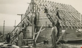
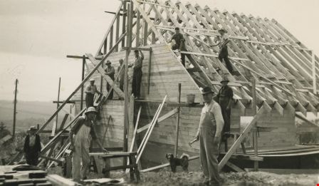
Construction of the Community Hall
https://search.heritageburnaby.ca/link/archivedescription36398
- Repository
- City of Burnaby Archives
- Date
- 1948
- Collection/Fonds
- Burnaby Historical Society fonds
- Description Level
- Item
- Physical Description
- 1 photograph : b&w ; 8 x 14 cm
- Scope and Content
- Photograph of the construction of the Capitol Hill Community Hall. The construction workers are all taking a break to look at the camera from their positions on the roof, the roof's ledge and the ground. A dog is also at the construction site.
- Repository
- City of Burnaby Archives
- Date
- 1948
- Collection/Fonds
- Burnaby Historical Society fonds
- Subseries
- Photographs subseries
- Physical Description
- 1 photograph : b&w ; 8 x 14 cm
- Description Level
- Item
- Record No.
- 258-003
- Access Restriction
- No restrictions
- Reproduction Restriction
- No known restrictions
- Accession Number
- BHS1991-21
- Scope and Content
- Photograph of the construction of the Capitol Hill Community Hall. The construction workers are all taking a break to look at the camera from their positions on the roof, the roof's ledge and the ground. A dog is also at the construction site.
- Subjects
- Construction
- Buildings - Recreational - Community Halls
- Occupations - Labourers
- Animals - Dogs
- Media Type
- Photograph
- Notes
- Title based on contents of photograph
- Geographic Access
- Howard Avenue
- Street Address
- 361 Howard Avenue
- Historic Neighbourhood
- Capitol Hill (Historic Neighbourhood)
- Planning Study Area
- Capitol Hill Area
Images

Construction on Acorn Avenue
https://search.heritageburnaby.ca/link/archivedescription79040
- Repository
- City of Burnaby Archives
- Date
- October 20, 1976
- Collection/Fonds
- Burnaby Public Library Contemporary Visual Archive Project
- Description Level
- Item
- Physical Description
- 1 photograph : b&w ; 11 x 16 cm mounted on cardboard
- Scope and Content
- Photograph shows a view from Hall Towers of houses and a high-rise under construction on Acorn Avenue.
- Repository
- City of Burnaby Archives
- Date
- October 20, 1976
- Collection/Fonds
- Burnaby Public Library Contemporary Visual Archive Project
- Physical Description
- 1 photograph : b&w ; 11 x 16 cm mounted on cardboard
- Description Level
- Item
- Record No.
- 556-108
- Access Restriction
- No restrictions
- Reproduction Restriction
- Reproduce for fair dealing purposes only
- Accession Number
- 2013-13
- Scope and Content
- Photograph shows a view from Hall Towers of houses and a high-rise under construction on Acorn Avenue.
- Media Type
- Photograph
- Photographer
- Ross, Martha
- Notes
- Scope note taken directly from BPL photograph description.
- 1 b&w copy negative : 10 x 12.5 cm accompanying
- Geographic Access
- Acorn Avenue
- Historic Neighbourhood
- Edmonds (Historic Neighbourhood)
- Planning Study Area
- Stride Avenue Area
Images


Road Construction
https://search.heritageburnaby.ca/link/archivedescription79978
- Repository
- City of Burnaby Archives
- Date
- September 20, 1976
- Collection/Fonds
- Burnaby Public Library Contemporary Visual Archive Project
- Description Level
- Item
- Physical Description
- 1 photograph : b&w ; 11 x 16 cm mounted on cardboard
- Scope and Content
- Photograph shows view of road construction on Broadway behind the Lake City Industrial Park.
- Repository
- City of Burnaby Archives
- Date
- September 20, 1976
- Collection/Fonds
- Burnaby Public Library Contemporary Visual Archive Project
- Physical Description
- 1 photograph : b&w ; 11 x 16 cm mounted on cardboard
- Description Level
- Item
- Record No.
- 556-534
- Access Restriction
- No restrictions
- Reproduction Restriction
- Reproduce for fair dealing purposes only
- Accession Number
- 2013-13
- Scope and Content
- Photograph shows view of road construction on Broadway behind the Lake City Industrial Park.
- Media Type
- Photograph
- Photographer
- Campbell, Peg
- Notes
- Scope note taken directly from BPL photograph description.
- 1 b&w copy negative : 10 x 12.5 cm accompanying
- Geographic Access
- Broadway
- Planning Study Area
- Lake City Area
Images

![Cariboo Cloverleaf, Government Road and Gaglardi Way, [1978] thumbnail](/media/hpo/_Data/_Archives_Images/_Unrestricted/480/480-274.jpg?width=280)
Cariboo Cloverleaf, Government Road and Gaglardi Way
https://search.heritageburnaby.ca/link/archivedescription45379
- Repository
- City of Burnaby Archives
- Date
- [1978]
- Collection/Fonds
- Columbian Newspaper collection
- Description Level
- Item
- Physical Description
- 1 photograph : b&w ; 22.5 x 19 cm
- Scope and Content
- Aerial photograph of the Cariboo Cloverleaf, and the Government Road overpass construction that would join it with Gaglardi Way.
- Repository
- City of Burnaby Archives
- Date
- [1978]
- Collection/Fonds
- Columbian Newspaper collection
- Physical Description
- 1 photograph : b&w ; 22.5 x 19 cm
- Description Level
- Item
- Record No.
- 480-274
- Access Restriction
- No restrictions
- Reproduction Restriction
- No restrictions
- Accession Number
- 2003-02
- Scope and Content
- Aerial photograph of the Cariboo Cloverleaf, and the Government Road overpass construction that would join it with Gaglardi Way.
- Media Type
- Photograph
- Photographer
- King, Basil
- Notes
- Title based on contents of photograph
- Note on recto of photograph reads: "Cariboo cloverleaf in foreground and Government Road overpass construction (centre) will join with Gaglardi Way (top of pic)."
- Geographic Access
- Government Road
- Cariboo Road
- Gaglardi Way
- Historic Neighbourhood
- Burquitlam (Historic Neighbourhood)
- Planning Study Area
- Burnaby Lake Area
- Cariboo-Armstrong Area
- Cameron Area
Images
![Cariboo Cloverleaf, Government Road and Gaglardi Way, [1978] thumbnail](/media/hpo/_Data/_Archives_Images/_Unrestricted/480/480-274.jpg)

Stormont Overpass
https://search.heritageburnaby.ca/link/archivedescription45376
- Repository
- City of Burnaby Archives
- Date
- August 1978
- Collection/Fonds
- Columbian Newspaper collection
- Description Level
- Item
- Physical Description
- 1 photograph : b&w ; 12.5 x 24 cm
- Scope and Content
- Aerial photograph of Stormont Overpass which would provide a direct link from the Trans Canada Highway (previously named the 401 Freeway) to the Lougheed Highway and Simon Fraser University. This was taken when the excavation work was completed, and grading and paving still need to be done.
- Repository
- City of Burnaby Archives
- Date
- August 1978
- Collection/Fonds
- Columbian Newspaper collection
- Physical Description
- 1 photograph : b&w ; 12.5 x 24 cm
- Description Level
- Item
- Record No.
- 480-271
- Access Restriction
- No restrictions
- Reproduction Restriction
- No restrictions
- Accession Number
- 2003-02
- Scope and Content
- Aerial photograph of Stormont Overpass which would provide a direct link from the Trans Canada Highway (previously named the 401 Freeway) to the Lougheed Highway and Simon Fraser University. This was taken when the excavation work was completed, and grading and paving still need to be done.
- Media Type
- Photograph
- Photographer
- Hodge, Craig
- Notes
- Title based on contents of photograph
- Note in pencil on verso of photograph reads: "Altair Aviation / photo by / Craig Hodge"
- Geographic Access
- Cariboo Road
- Gaglardi Way
- Trans Canada Highway
- Historic Neighbourhood
- Burquitlam (Historic Neighbourhood)
- Planning Study Area
- Burnaby Lake Area
- Cameron Area
Images


Stormont Overpass
https://search.heritageburnaby.ca/link/archivedescription45377
- Repository
- City of Burnaby Archives
- Date
- August 1978
- Collection/Fonds
- Columbian Newspaper collection
- Description Level
- Item
- Physical Description
- 1 photograph : b&w ; 16.5 x 24 cm
- Scope and Content
- Aerial photograph of Stormont Overpass which would provide a direct link from the 401 Freeway to the Lougheed Highway and Simon Fraser University. This was taken when the excavation work was completed, and grading and paving still need to be done.
- Repository
- City of Burnaby Archives
- Date
- August 1978
- Collection/Fonds
- Columbian Newspaper collection
- Physical Description
- 1 photograph : b&w ; 16.5 x 24 cm
- Description Level
- Item
- Record No.
- 480-272
- Access Restriction
- No restrictions
- Reproduction Restriction
- No restrictions
- Accession Number
- 2003-02
- Scope and Content
- Aerial photograph of Stormont Overpass which would provide a direct link from the 401 Freeway to the Lougheed Highway and Simon Fraser University. This was taken when the excavation work was completed, and grading and paving still need to be done.
- Media Type
- Photograph
- Photographer
- Hodge, Craig
- Notes
- Title based on contents of photograph
- Newspaper clipping attached to verso of photograph reads: "After six years, work on the Stormont interchange in Burnaby is only a few weeks from completion. The huge clover-leaf junction of Gaglardi Way and the Freeway is on the top left-hand corner, with Gaglardi Way approaching from the bottom right where a bridge has been completed over the Burlington Northern tracks. An embankment linking that bridge with one over the Brunette River awaits only a layer of tarmac, and a path has been cleared through the woods to link up with the clover-leaf. The present access to the Freeway is along the road running from the left to right across the middle of the picture. The interchange will open next month."
- Note in pencil on verso of photograph reads: "Altair Aviation / photo by / Craig Hodge"
- Geographic Access
- Cariboo Road
- Gaglardi Way
- Trans Canada Highway
- Historic Neighbourhood
- Burquitlam (Historic Neighbourhood)
- Planning Study Area
- Burnaby Lake Area
- Cameron Area
Images

![Stormont Overpass, [1978] thumbnail](/media/hpo/_Data/_Archives_Images/_Unrestricted/480/480-275.jpg?width=280)
Stormont Overpass
https://search.heritageburnaby.ca/link/archivedescription45380
- Repository
- City of Burnaby Archives
- Date
- [1978]
- Collection/Fonds
- Columbian Newspaper collection
- Description Level
- Item
- Physical Description
- 1 photograph : b&w ; 16 x 24 cm
- Scope and Content
- Aerial photograph of Stormont Overpass which would provide a direct link from the Trans Canada Highway (previously named the 401 Freeway) to the Lougheed Highway and Simon Fraser University. This was taken when the excavation work was completed, and paving still need to be done.
- Repository
- City of Burnaby Archives
- Date
- [1978]
- Collection/Fonds
- Columbian Newspaper collection
- Physical Description
- 1 photograph : b&w ; 16 x 24 cm
- Description Level
- Item
- Record No.
- 480-275
- Access Restriction
- No restrictions
- Reproduction Restriction
- No restrictions
- Accession Number
- 2003-02
- Scope and Content
- Aerial photograph of Stormont Overpass which would provide a direct link from the Trans Canada Highway (previously named the 401 Freeway) to the Lougheed Highway and Simon Fraser University. This was taken when the excavation work was completed, and paving still need to be done.
- Media Type
- Photograph
- Photographer
- King, Basil
- Notes
- Title based on contents of photograph
- Note on verso of photograph reads: "One of the biggest Highways"
- Geographic Access
- Cariboo Road
- Gaglardi Way
- Trans Canada Highway
- Historic Neighbourhood
- Burquitlam (Historic Neighbourhood)
- Planning Study Area
- Burnaby Lake Area
- Cameron Area
Images
![Stormont Overpass, [1978] thumbnail](/media/hpo/_Data/_Archives_Images/_Unrestricted/480/480-275.jpg)
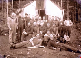
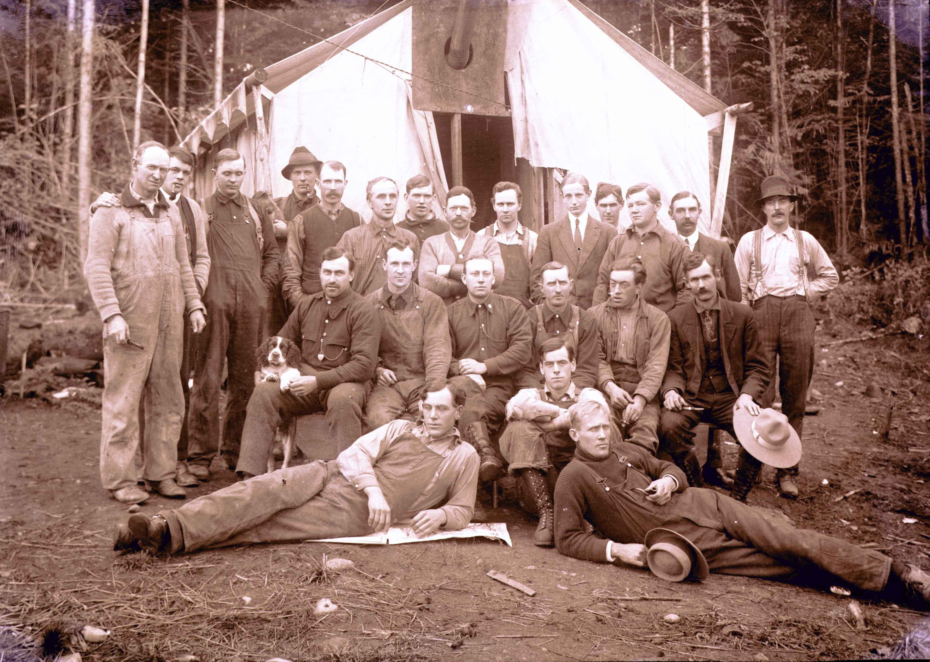
Streetcar work camp
https://search.heritageburnaby.ca/link/archivedescription57707
- Repository
- City of Burnaby Archives
- Date
- 1913
- Collection/Fonds
- J.W. Phillips fonds
- Description Level
- Item
- Physical Description
- 1 photograph : b&w glass negative ; 11 x 15.5 cm
- Scope and Content
- Photograph of labourers at the British Columbia Electric Railway Company streetcar work camp standing and sitting in three rows in front of a large tent at Hastings Street. The man on the far right, sitting upright, is holding a cocker spaniel at his knee. This photograph was taken during construct…
- Repository
- City of Burnaby Archives
- Date
- 1913
- Collection/Fonds
- J.W. Phillips fonds
- Physical Description
- 1 photograph : b&w glass negative ; 11 x 15.5 cm
- Material Details
- Emulsion measures 11 x 15.5 cm on the glass; entire glass plate measures 12 x 16 cm
- Description Level
- Item
- Record No.
- 487-011
- Access Restriction
- No restrictions
- Reproduction Restriction
- No known restrictions
- Accession Number
- 2008-18
- Scope and Content
- Photograph of labourers at the British Columbia Electric Railway Company streetcar work camp standing and sitting in three rows in front of a large tent at Hastings Street. The man on the far right, sitting upright, is holding a cocker spaniel at his knee. This photograph was taken during construction of the Hastings Streetcar line extension.
- Subjects
- Transportation - Electric Railroads
- Construction - Railroad Construction
- Occupations - Railroad Labourers
- Structures - Tents
- Animals - Dogs
- Media Type
- Photograph
- Photographer
- Phillips, James William "Jim"
- Notes
- Title based on contents of photograph
- Geographic Access
- Hastings Street
Images

Streetcar work camp
https://search.heritageburnaby.ca/link/archivedescription57708
- Repository
- City of Burnaby Archives
- Date
- 1913
- Collection/Fonds
- J.W. Phillips fonds
- Description Level
- Item
- Physical Description
- 1 photograph : b&w glass negative ; 11 x 15.5 cm
- Scope and Content
- Photograph of labourers at the British Columbia Electric Railway Company streetcar work camp standing and sitting in three rows in front of a large tent at Hastings Street. The man on the far right, sitting upright, is holding a cocker spaniel at his knee. This photograph was taken during construc…
- Repository
- City of Burnaby Archives
- Date
- 1913
- Collection/Fonds
- J.W. Phillips fonds
- Physical Description
- 1 photograph : b&w glass negative ; 11 x 15.5 cm
- Material Details
- Emulsion measures 11 x 15.5 cm on the glass; entire glass plate measures 12 x 16 cm
- Description Level
- Item
- Record No.
- 487-012
- Access Restriction
- No restrictions
- Reproduction Restriction
- No known restrictions
- Accession Number
- 2008-18
- Scope and Content
- Photograph of labourers at the British Columbia Electric Railway Company streetcar work camp standing and sitting in three rows in front of a large tent at Hastings Street. The man on the far right, sitting upright, is holding a cocker spaniel at his knee. This photograph was taken during construction of the Hastings Streetcar line extension.
- Subjects
- Transportation - Electric Railroads
- Construction - Railroad Construction
- Occupations - Railroad Labourers
- Structures - Tents
- Animals - Dogs
- Media Type
- Photograph
- Photographer
- Phillips, James William "Jim"
- Notes
- Title based on contents of photograph
- Geographic Access
- Hastings Street
Images
Napier Street and Madison Avenue
https://search.heritageburnaby.ca/link/archivedescription34096
- Repository
- City of Burnaby Archives
- Date
- March 16, 1947
- Collection/Fonds
- Burnaby Historical Society fonds
- Description Level
- Item
- Physical Description
- 1 photograph : b&w negative ; 6.8 x 11.3 cm
- Scope and Content
- Photograph of house construction at Napier Street (west) and Madison Avenue with and a man and dog on the road. Other houses are visible in the background. This is part of the Willingdon Heights subdivision site.
- Repository
- City of Burnaby Archives
- Date
- March 16, 1947
- Collection/Fonds
- Burnaby Historical Society fonds
- Subseries
- Alfred Bingham subseries
- Physical Description
- 1 photograph : b&w negative ; 6.8 x 11.3 cm
- Description Level
- Item
- Record No.
- 010-012
- Access Restriction
- No restrictions
- Reproduction Restriction
- No known restrictions
- Accession Number
- BHS2007-04
- Scope and Content
- Photograph of house construction at Napier Street (west) and Madison Avenue with and a man and dog on the road. Other houses are visible in the background. This is part of the Willingdon Heights subdivision site.
- Media Type
- Photograph
- Photographer
- Bingham, Alfred "Alf"
- Notes
- Title based on contents of photograph
- Geographic Access
- Napier Street
- Madison Avenue
Images

Napier Street and Madison Avenue
https://search.heritageburnaby.ca/link/archivedescription34101
- Repository
- City of Burnaby Archives
- Date
- March 16, 1947
- Collection/Fonds
- Burnaby Historical Society fonds
- Description Level
- Item
- Physical Description
- 1 photograph : b&w negative ; 6.8 x 11.4 cm
- Scope and Content
- Photograph of the 4300 block of Napier Street at Madison Avenue with several houses under construction, piles of lumber, and a man and dogs outside one of the houses. This is part of the Willingdon Heights subdivision site.
- Repository
- City of Burnaby Archives
- Date
- March 16, 1947
- Collection/Fonds
- Burnaby Historical Society fonds
- Subseries
- Alfred Bingham subseries
- Physical Description
- 1 photograph : b&w negative ; 6.8 x 11.4 cm
- Description Level
- Item
- Record No.
- 010-017
- Access Restriction
- No restrictions
- Reproduction Restriction
- No known restrictions
- Accession Number
- BHS2007-04
- Scope and Content
- Photograph of the 4300 block of Napier Street at Madison Avenue with several houses under construction, piles of lumber, and a man and dogs outside one of the houses. This is part of the Willingdon Heights subdivision site.
- Media Type
- Photograph
- Photographer
- Bingham, Alfred "Alf"
- Notes
- Title based on contents of photograph
- Geographic Access
- Napier Street
Images
Aerial photograph of Burnaby Mountain
https://search.heritageburnaby.ca/link/archivedescription64460
- Repository
- City of Burnaby Archives
- Date
- [1957 or 1958]
- Collection/Fonds
- Burnaby Historical Society fonds
- Description Level
- Item
- Physical Description
- 1 photograph : b&w ; 14 x 14 cm
- Scope and Content
- Aerial photograph of the Burnaby Mountain park and Centennial Pavilion, under construction.
- Repository
- City of Burnaby Archives
- Date
- [1957 or 1958]
- Collection/Fonds
- Burnaby Historical Society fonds
- Subseries
- North Burnaby Board of Trade subseries
- Physical Description
- 1 photograph : b&w ; 14 x 14 cm
- Description Level
- Item
- Record No.
- 476-026
- Access Restriction
- No restrictions
- Reproduction Restriction
- Reproduce for fair dealing purposes only
- Accession Number
- BHS2005-8
- Scope and Content
- Aerial photograph of the Burnaby Mountain park and Centennial Pavilion, under construction.
- Subjects
- Aerial Photographs
- Land Clearing
- Media Type
- Photograph
- Photographer
- Hunting Survey Corporation Limited
- Notes
- Title based on contents of photograph
- Geographic Access
- Burnaby Mountain Conservation Area
- Centennial Way
- Street Address
- 100 Centennial Way
- Planning Study Area
- Burnaby Mountain Area
![Aerial photograph of Burnaby Mountain, [1957 or 1958] thumbnail](/media/hpo/_Data/_Archives_Images/_Unrestricted/371/476-025.jpg?width=280)
Aerial photograph of Burnaby Mountain
https://search.heritageburnaby.ca/link/archivedescription39742
- Repository
- City of Burnaby Archives
- Date
- [1957 or 1958]
- Collection/Fonds
- Burnaby Historical Society fonds
- Description Level
- Item
- Physical Description
- 1 photograph : b&w ; 14 x 14 cm
- Scope and Content
- Aerial photograph of the Burnaby Mountain park and Centennial Pavilion, under construction.
- Repository
- City of Burnaby Archives
- Date
- [1957 or 1958]
- Collection/Fonds
- Burnaby Historical Society fonds
- Subseries
- North Burnaby Board of Trade subseries
- Physical Description
- 1 photograph : b&w ; 14 x 14 cm
- Description Level
- Item
- Record No.
- 476-025
- Access Restriction
- No restrictions
- Reproduction Restriction
- Reproduce for fair dealing purposes only
- Accession Number
- BHS2005-8
- Scope and Content
- Aerial photograph of the Burnaby Mountain park and Centennial Pavilion, under construction.
- Subjects
- Aerial Photographs
- Land Clearing
- Media Type
- Photograph
- Photographer
- Hunting Survey Corporation Limited
- Notes
- Title based on contents of photograph.
- Geographic Access
- Burnaby Mountain Conservation Area
- Centennial Way
- Street Address
- 100 Centennial Way
- Planning Study Area
- Burnaby Mountain Area
Images
![Aerial photograph of Burnaby Mountain, [1957 or 1958] thumbnail](/media/hpo/_Data/_Archives_Images/_Unrestricted/371/476-025.jpg)

Aerial photograph of Grandview Highway
https://search.heritageburnaby.ca/link/archivedescription37876
- Repository
- City of Burnaby Archives
- Date
- July 1952 (date of original), copied 1991
- Collection/Fonds
- Burnaby Historical Society fonds
- Description Level
- Item
- Physical Description
- 1 photograph : b&w ; 3.4 x 4.3 cm print on contact sheet 20.1 x 26.7 cm
- Scope and Content
- Aerial photograph of Cascade Drive-In Theatre at 4050 Grandview Highway and the surrounding area. Note: Burnaby General Hospital under construction can be seen on the left.
- Repository
- City of Burnaby Archives
- Date
- July 1952 (date of original), copied 1991
- Collection/Fonds
- Burnaby Historical Society fonds
- Subseries
- Burnaby Image Bank subseries
- Physical Description
- 1 photograph : b&w ; 3.4 x 4.3 cm print on contact sheet 20.1 x 26.7 cm
- Description Level
- Item
- Record No.
- 370-464
- Access Restriction
- No restrictions
- Reproduction Restriction
- No restrictions
- Accession Number
- BHS1999-03
- Scope and Content
- Aerial photograph of Cascade Drive-In Theatre at 4050 Grandview Highway and the surrounding area. Note: Burnaby General Hospital under construction can be seen on the left.
- Subjects
- Aerial Photographs
- Media Type
- Photograph
- Photographer
- Cunningham, W.
- Notes
- Title based on contents of photograph
- 1 b&w copy negative accompanying
- Negative has a pink cast
- Geographic Access
- Grandview Highway
- Street Address
- 4050 Grandview Highway
- Historic Neighbourhood
- Broadview (Historic Neighbourhood)
- Planning Study Area
- Cascade-Schou Area
- West Central Valley Area
Images

![Aerial view of Burnaby Lake, October 20, 1961 (date of original), copied [1985] thumbnail](/media/hpo/_Data/_BVM_Images/1985/1985_0457_0002_001.jpg?width=280)
Aerial view of Burnaby Lake
https://search.heritageburnaby.ca/link/museumdescription10583
- Repository
- Burnaby Village Museum
- Date
- October 20, 1961 (date of original), copied [1985]
- Collection/Fonds
- Burnaby Village Museum Photograph collection
- Description Level
- Item
- Physical Description
- 1 photograph : b&w copy negative ; 10 x 12 cm
- Scope and Content
- Photograph of aerial view of Burnaby Lake and construction for water main crossing at Piper Avenue.
- Repository
- Burnaby Village Museum
- Collection/Fonds
- Burnaby Village Museum Photograph collection
- Description Level
- Item
- Physical Description
- 1 photograph : b&w copy negative ; 10 x 12 cm
- Scope and Content
- Photograph of aerial view of Burnaby Lake and construction for water main crossing at Piper Avenue.
- Accession Code
- BV985.457.2
- Access Restriction
- No restrictions
- Reproduction Restriction
- May be restricted by third party rights
- Date
- October 20, 1961 (date of original), copied [1985]
- Media Type
- Photograph
- Historic Neighbourhood
- Burnaby Lake (Historic Neighbourhood)
- Planning Study Area
- Burnaby Lake Area
- Scan Resolution
- 1200
- Scan Date
- 2022-06-07
- Photographer
- George Allen Aerial Photos Limited
- Notes
- Title based on contents of photograph
Images
![Aerial view of Burnaby Lake, October 20, 1961 (date of original), copied [1985] thumbnail](/media/hpo/_Data/_BVM_Images/1985/1985_0457_0002_001.jpg)
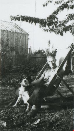
Jim Ellis and his dog
https://search.heritageburnaby.ca/link/archivedescription37726
- Repository
- City of Burnaby Archives
- Date
- 1938 (date of original), copied 1991
- Collection/Fonds
- Burnaby Historical Society fonds
- Description Level
- Item
- Physical Description
- 1 photograph : b&w ; 4.0 x 2.3 cm print on contact sheet 20.4 x 26.5 cm
- Scope and Content
- Photograph of Jim Ellis, with his dog, Bill, seated at the back of the Ellis home at 6926 Nelson Avenue. There is construction occurring in the background. The photograph was taken during the summer of 1938.
- Repository
- City of Burnaby Archives
- Date
- 1938 (date of original), copied 1991
- Collection/Fonds
- Burnaby Historical Society fonds
- Subseries
- Burnaby Image Bank subseries
- Physical Description
- 1 photograph : b&w ; 4.0 x 2.3 cm print on contact sheet 20.4 x 26.5 cm
- Description Level
- Item
- Record No.
- 370-314
- Access Restriction
- No restrictions
- Reproduction Restriction
- No known restrictions
- Accession Number
- BHS1999-03
- Scope and Content
- Photograph of Jim Ellis, with his dog, Bill, seated at the back of the Ellis home at 6926 Nelson Avenue. There is construction occurring in the background. The photograph was taken during the summer of 1938.
- Subjects
- Animals - Dogs
- Names
- Elllis, Jim
- Media Type
- Photograph
- Notes
- Title based on contents of photograph
- 1 b&w copy negative accompanying
- Negative has a pink cast
- Geographic Access
- Nelson Avenue
- Street Address
- 6926 Nelson Avenue
- Historic Neighbourhood
- Central Park (Historic Neighbourhood)
- Planning Study Area
- Sussex-Nelson Area
Images


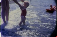
McLean family at a beach and cabin
https://search.heritageburnaby.ca/link/archivedescription85425
- Repository
- City of Burnaby Archives
- Date
- 1963
- Collection/Fonds
- George H.F. McLean fonds
- Description Level
- Item
- Physical Description
- 1 digital file ( 4 min., 26 sec ) : digital , col., si.
- Scope and Content
- Item consists of one silent colour film and opens with footage of Teresa McLean and her mother, Edna at the oceanside on Bowyer Island and is followed with footage of a man and George McLean building a cabin with help from some of the McLean children. The following footage is a little poor and jump…
- Repository
- City of Burnaby Archives
- Date
- 1963
- Collection/Fonds
- George H.F. McLean fonds
- Physical Description
- 1 digital file ( 4 min., 26 sec ) : digital , col., si.
- Description Level
- Item
- Record No.
- 567-001-10
- Access Restriction
- No restrictions
- Reproduction Restriction
- May be restricted by third party rights
- Accession Number
- 2014-03
- Scope and Content
- Item consists of one silent colour film and opens with footage of Teresa McLean and her mother, Edna at the oceanside on Bowyer Island and is followed with footage of a man and George McLean building a cabin with help from some of the McLean children. The following footage is a little poor and jumpy but continues with views of the family swimming and playing at the beach and playing around the cabin that is under construction.
- Media Type
- Moving Images
- Photographer
- McLean, George H.F.
- Notes
- Title based on content of film
- Films originated in an 8mm format and were digitized by George McLean before being donated to the CBA
Images
Video
McLean family at a beach and cabin, 1963
McLean family at a beach and cabin, 1963
https://search.heritageburnaby.ca/media/hpo/_Data/_Archives_Moving_Images/_Unrestricted/567-001-10.m4v![Pacific Assistance Dogs Society training, [2003] thumbnail](/media/hpo/_Data/_Archives_Images/_Unrestricted/535/535-1836.jpg?width=280)
Pacific Assistance Dogs Society training
https://search.heritageburnaby.ca/link/archivedescription96139
- Repository
- City of Burnaby Archives
- Date
- [2003]
- Collection/Fonds
- Burnaby NewsLeader photograph collection
- Description Level
- Item
- Physical Description
- 1 photograph (tiff) : col.
- Scope and Content
- Photograph of Ron Tymrick, an instructor for the Pacific Assistance Dogs Society (PADS), outdoors with a Golden Retriever dog. The dog has its paws up on the table in front of them and holds a set of keys in its mouth.
- Repository
- City of Burnaby Archives
- Date
- [2003]
- Collection/Fonds
- Burnaby NewsLeader photograph collection
- Physical Description
- 1 photograph (tiff) : col.
- Description Level
- Item
- Record No.
- 535-1836
- Access Restriction
- No restrictions
- Reproduction Restriction
- No restrictions
- Accession Number
- 2018-12
- Scope and Content
- Photograph of Ron Tymrick, an instructor for the Pacific Assistance Dogs Society (PADS), outdoors with a Golden Retriever dog. The dog has its paws up on the table in front of them and holds a set of keys in its mouth.
- Subjects
- Animals - Dogs
- Organizations - Charities
- Media Type
- Photograph
- Photographer
- Bartel, Mario
- Notes
- Title based on caption
- Collected by editorial for use in a February 2003 issue of the Burnaby NewsLeader
- Caption from metadata: "Ron Tymrick, an instructor for the Pacific Assistance Dogs Society, works with Freesia, a two-year old Golden Retriever who's six months into her training and almost ready to be placed. The Society will soon begin construction of a dormitory where clients will stay as they're being familiarized with their new dog."
Images
![Pacific Assistance Dogs Society training, [2003] thumbnail](/media/hpo/_Data/_Archives_Images/_Unrestricted/535/535-1836.jpg)

MacInnis Place and Lougheed Village
https://search.heritageburnaby.ca/link/archivedescription45407
- Repository
- City of Burnaby Archives
- Date
- March 1976
- Collection/Fonds
- Columbian Newspaper collection
- Description Level
- Item
- Physical Description
- 1 photograph : b&w ; 14 x 19.5 cm
- Scope and Content
- Aerial photograph of MacInnis Place with Lougheed Village in behind. MacInnis Place housing development was constructed with the intent of having 25% of its suites rented at a reduced cost to low income earners.
- Repository
- City of Burnaby Archives
- Date
- March 1976
- Collection/Fonds
- Columbian Newspaper collection
- Physical Description
- 1 photograph : b&w ; 14 x 19.5 cm
- Description Level
- Item
- Record No.
- 480-302
- Access Restriction
- No restrictions
- Reproduction Restriction
- No restrictions
- Accession Number
- 2003-02
- Scope and Content
- Aerial photograph of MacInnis Place with Lougheed Village in behind. MacInnis Place housing development was constructed with the intent of having 25% of its suites rented at a reduced cost to low income earners.
- Subjects
- Aerial Photographs
- Media Type
- Photograph
- Photographer
- King, Basil
- Notes
- Title based on contents of photograph
- Historic Neighbourhood
- Burquitlam (Historic Neighbourhood)
- Planning Study Area
- Cameron Area
Images

![Rocks from Burnaby Muncipal Hall at Edmonds, [1970] thumbnail](/media/hpo/_Data/_BVM_Images//2022/2022_0009_0004_001.jpg?width=280)
Rocks from Burnaby Muncipal Hall at Edmonds
https://search.heritageburnaby.ca/link/museumdescription18453
- Repository
- Burnaby Village Museum
- Date
- [1970]
- Collection/Fonds
- Burnaby Centennial '71 Committee collection
- Description Level
- Item
- Physical Description
- 1 photograph : b&w ; 9 x 12.5 cm
- Scope and Content
- Photograph of rocks after being removed from the lower section of the former Burnaby Municipal Hall at Kingsway and Edmonds. Parts of the building were being considered for Heritage Village that was constructed in 1971.
- Repository
- Burnaby Village Museum
- Collection/Fonds
- Burnaby Centennial '71 Committee collection
- Description Level
- Item
- Physical Description
- 1 photograph : b&w ; 9 x 12.5 cm
- Scope and Content
- Photograph of rocks after being removed from the lower section of the former Burnaby Municipal Hall at Kingsway and Edmonds. Parts of the building were being considered for Heritage Village that was constructed in 1971.
- Subjects
- Building Components
- Names
- Burnaby City Hall
- Accession Code
- BV022.9.4
- Access Restriction
- No restrictions
- Reproduction Restriction
- No known restrictions
- Date
- [1970]
- Media Type
- Photograph
- Scan Resolution
- 600
- Scan Date
- 2022-03-15
- Photographer
- Lott, Richard
- Notes
- Title based on contents of photograph
- Handwritten note in blue ink on verso of photograph reads: "1st Bby jail rocks / & bars 1970"
- Stamp in black ink on verso of photograph reads: "78IH"
Images
![Rocks from Burnaby Muncipal Hall at Edmonds, [1970] thumbnail](/media/hpo/_Data/_BVM_Images//2022/2022_0009_0004_001.jpg)