Narrow Results By

Barnet mill
https://search.heritageburnaby.ca/link/museumdescription15219
- Repository
- Burnaby Village Museum
- Date
- 1934 (date of original), copied 2004
- Collection/Fonds
- In the Shadow by the Sea collection
- Description Level
- Item
- Physical Description
- 1 photograph (tiff) : 300 dpi
- Scope and Content
- Photograph of the Barnet Mill on the shore of Burrard Inlet. Mill buildings including lodgings are visible.
- Repository
- Burnaby Village Museum
- Collection/Fonds
- In the Shadow by the Sea collection
- Description Level
- Item
- Physical Description
- 1 photograph (tiff) : 300 dpi
- Scope and Content
- Photograph of the Barnet Mill on the shore of Burrard Inlet. Mill buildings including lodgings are visible.
- Names
- Barnet Mill
- Geographic Access
- Burrard Inlet
- Accession Code
- BV019.32.39
- Access Restriction
- No restrictions
- Reproduction Restriction
- No known restrictions
- Date
- 1934 (date of original), copied 2004
- Media Type
- Photograph
- Historic Neighbourhood
- Barnet (Historic Neighbourhood)
- Planning Study Area
- Burnaby Mountain Area
- Notes
- Title based on contents of photograph
- Historical information provided by Burnaby Heritage Planning - Barnet Neighbourhood
Images


Barnet mill burner
https://search.heritageburnaby.ca/link/museumdescription15221
- Repository
- Burnaby Village Museum
- Date
- 1937 (date of original), copied 2004
- Collection/Fonds
- In the Shadow by the Sea collection
- Description Level
- Item
- Physical Description
- 1 photograph (tiff) : 300 dpi
- Scope and Content
- Photograph of the site of the old Barnet Mill burner along the shore of Burrard Inlet. Pilings and rail tracks are visible along the shore. B.C. Electric transmisson towers are visible at the top of the site. Photograph is taken from the water looking south.
- Repository
- Burnaby Village Museum
- Collection/Fonds
- In the Shadow by the Sea collection
- Description Level
- Item
- Physical Description
- 1 photograph (tiff) : 300 dpi
- Scope and Content
- Photograph of the site of the old Barnet Mill burner along the shore of Burrard Inlet. Pilings and rail tracks are visible along the shore. B.C. Electric transmisson towers are visible at the top of the site. Photograph is taken from the water looking south.
- Names
- Barnet Mill
- Geographic Access
- Burrard Inlet
- Accession Code
- BV019.32.41
- Access Restriction
- No restrictions
- Reproduction Restriction
- No known restrictions
- Date
- 1937 (date of original), copied 2004
- Media Type
- Photograph
- Historic Neighbourhood
- Barnet (Historic Neighbourhood)
- Planning Study Area
- Burnaby Mountain Area
- Notes
- Title based on contents of photograph
- Historical information provided by Burnaby Heritage Planning - Barnet Neighbourhood
Images

Mill burner
https://search.heritageburnaby.ca/link/museumdescription15220
- Repository
- Burnaby Village Museum
- Date
- 1937 (date of original), copied 2004
- Collection/Fonds
- In the Shadow by the Sea collection
- Description Level
- Item
- Physical Description
- 1 photograph (tiff) : 300 dpi
- Scope and Content
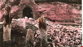
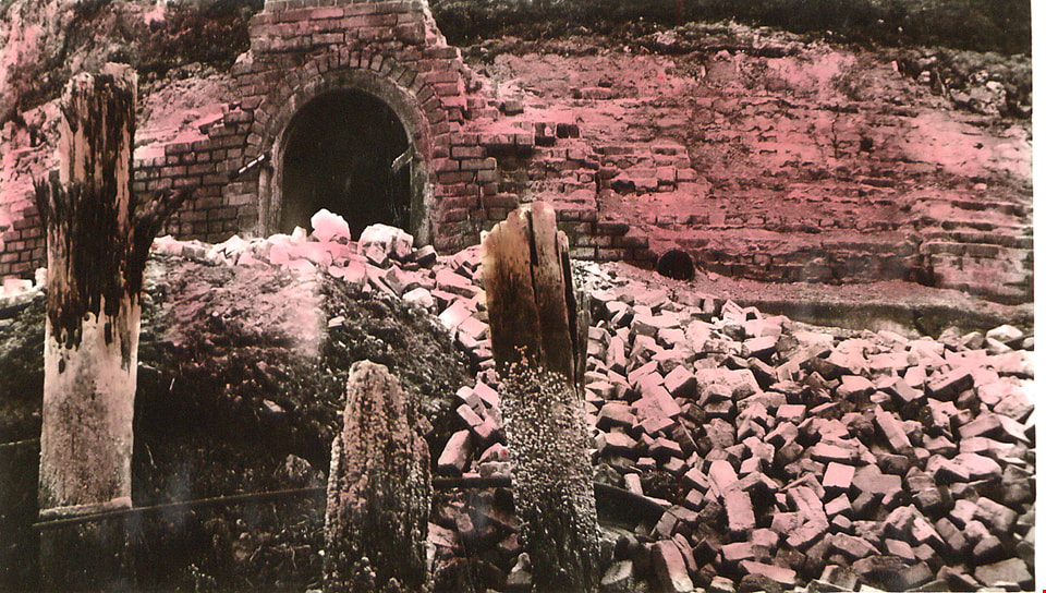
- Photograph of the crumbling foundation of the old Barnet Mill burner. Bricks from the former burner are piled on the shore in front of the burner entrance. Old pilings encrusted with barnacles are visible in the foreground.
- Repository
- Burnaby Village Museum
- Collection/Fonds
- In the Shadow by the Sea collection
- Description Level
- Item
- Physical Description
- 1 photograph (tiff) : 300 dpi
- Scope and Content
- Photograph of the crumbling foundation of the old Barnet Mill burner. Bricks from the former burner are piled on the shore in front of the burner entrance. Old pilings encrusted with barnacles are visible in the foreground.
- Names
- Barnet Mill
- Geographic Access
- Burrard Inlet
- Accession Code
- BV019.32.40
- Access Restriction
- No restrictions
- Reproduction Restriction
- No known restrictions
- Date
- 1937 (date of original), copied 2004
- Media Type
- Photograph
- Historic Neighbourhood
- Barnet (Historic Neighbourhood)
- Planning Study Area
- Burnaby Mountain Area
- Notes
- Title based on contents of photograph
- See page 120 of book "In the Shadow by the Sea - Recollections of Burnaby's Barnet Village". Caption with photograph reads: "The crumbling foundation of the old mill burner, 1937"
- Historical information provided by Burnaby Heritage Planning - Barnet Neighbourhood
Images
Seaforth School dedication
https://search.heritageburnaby.ca/link/archivedescription35124
- Repository
- City of Burnaby Archives
- Date
- April 1987
- Collection/Fonds
- Burnaby Historical Society fonds
- Description Level
- Item
- Physical Description
- 1 photograph : col. ; 12.6 x 17.4 cm print
- Scope and Content
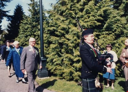
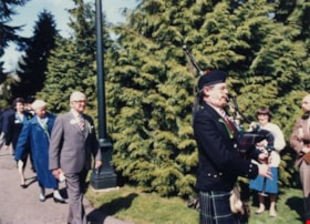
- Photograph of the opening of Seaforth School at the Burnaby Village Museum, with a piper leading the procession. The school was moved from its original location at 7881 Government Road to Burnaby Village Museum in 1983, and was opened to the public in 1987.
- Repository
- City of Burnaby Archives
- Date
- April 1987
- Collection/Fonds
- Burnaby Historical Society fonds
- Subseries
- Donald N. Brown subseries
- Physical Description
- 1 photograph : col. ; 12.6 x 17.4 cm print
- Description Level
- Item
- Record No.
- 194-001
- Access Restriction
- No restrictions
- Reproduction Restriction
- Reproduce for fair dealing purposes only
- Accession Number
- BHS1987-03
- Scope and Content
- Photograph of the opening of Seaforth School at the Burnaby Village Museum, with a piper leading the procession. The school was moved from its original location at 7881 Government Road to Burnaby Village Museum in 1983, and was opened to the public in 1987.
- Media Type
- Photograph
- Notes
- Title based on contents of photograph
- An annotation on the back of the photograph reads; "Bell Irving, Brig. / Honourary Colonel Seaforths / Dedication of Seaforth School / Burnaby Heritage Village / April, 1987 / Being "Piped" in followed by x-students."
- Geographic Access
- Deer Lake Drive
- Street Address
- 6501 Deer Lake Avenue
- Historic Neighbourhood
- Burnaby Lake (Historic Neighbourhood)
- Planning Study Area
- Morley-Buckingham Area
Images