Narrow Results By
Subject
- Accidents - Train Accidents
- Adornment - Jewelry 1
- Advertising Medium 1
- Advertising Medium - Signs and Signboards 7
- Aerial Photographs
- Animals - Birds 1
- Animals - Horses 1
- Arts - Paintings 6
- Buildings - Agricultural - Greenhouses 1
- Buildings - Commercial 2
- Buildings - Commercial - Drive-in Theatres 11
- Buildings - Commercial - Hardware Stores 4

Aerial view of Lougheed Highway
https://search.heritageburnaby.ca/link/archivedescription78860
- Repository
- City of Burnaby Archives
- Date
- September 27, 1976
- Collection/Fonds
- Burnaby Public Library Contemporary Visual Archive Project
- Description Level
- Item
- Physical Description
- 1 photograph : b&w ; 11 x 16 cm mounted on cardboard
- Scope and Content
- Photograph is an aerial view of Lougheed Highway, looking northwest from 9304 Salish Court - Tower West.
- Repository
- City of Burnaby Archives
- Date
- September 27, 1976
- Collection/Fonds
- Burnaby Public Library Contemporary Visual Archive Project
- Physical Description
- 1 photograph : b&w ; 11 x 16 cm mounted on cardboard
- Description Level
- Item
- Record No.
- 556-006
- Access Restriction
- No restrictions
- Reproduction Restriction
- Reproduce for fair dealing purposes only
- Accession Number
- 2013-13
- Scope and Content
- Photograph is an aerial view of Lougheed Highway, looking northwest from 9304 Salish Court - Tower West.
- Subjects
- Aerial Photographs
- Media Type
- Photograph
- Photographer
- Campbell, Peg
- Notes
- Scope note taken directly from BPL photograph description.
- 1 b&w copy negative : 10 x 12.5 cm accompanying
- Geographic Access
- Lougheed Highway
- Salish Court
- Historic Neighbourhood
- Burquitlam (Historic Neighbourhood)
- Planning Study Area
- Cameron Area
Images

![Lenkurt Electric Company, [1957] thumbnail](/media/Hpo/_Data/_Archives_Images/_Unrestricted/001/099-001.jpg?width=280)
Lenkurt Electric Company
https://search.heritageburnaby.ca/link/archivedescription34690
- Repository
- City of Burnaby Archives
- Date
- [1957]
- Collection/Fonds
- Burnaby Historical Society fonds
- Description Level
- Item
- Physical Description
- 1 photograph : b&w ; 20.3 x 25.3 cm
- Scope and Content
- Photograph of aerial view of the Lenkurt Electric Company at 6960 Lougheed Highway (later renumbered 7018 Lougheed Highway). A sign on the top of the building reads, "Lenkurt." An information sheet from the Company Relation Division of Lenkurt attached to the back of the photograph reads, "Aerial…
- Repository
- City of Burnaby Archives
- Date
- [1957]
- Collection/Fonds
- Burnaby Historical Society fonds
- Subseries
- Photographs subseries
- Physical Description
- 1 photograph : b&w ; 20.3 x 25.3 cm
- Description Level
- Item
- Record No.
- 099-001
- Access Restriction
- No restrictions
- Reproduction Restriction
- Reproduce for fair dealing purposes only
- Accession Number
- BHS2007-04
- Scope and Content
- Photograph of aerial view of the Lenkurt Electric Company at 6960 Lougheed Highway (later renumbered 7018 Lougheed Highway). A sign on the top of the building reads, "Lenkurt." An information sheet from the Company Relation Division of Lenkurt attached to the back of the photograph reads, "Aerial view of a 34,000 square foot building including a 19,000 square foot extension to the existing 15,000 square foot plant of Lenkurt Electric Co. of Canada Ltd. in North Burnaby, B.C., as at May 10th, 1957. / The building is situated on 20 acres of land and faces north onto Lougheed Highway."
- Names
- Lenkurt Electric Company
- Media Type
- Photograph
- Photographer
- Commercial Illustrators Industrial Photographers
- Notes
- Title based on contents of photograph
- Stamp and annotation on back of photograph reads, "TA. 8817 / Commerical Illustrators / Industrial Photographers / 601 Denman St., Vancouver 5, B.C. / File No. 1080-1"
- Geographic Access
- Lougheed Highway
- Street Address
- 7018 Lougheed Highway
- Historic Neighbourhood
- Lozells (Historic Neighbourhood)
- Planning Study Area
- Government Road Area
Images
![Lenkurt Electric Company, [1957] thumbnail](/media/Hpo/_Data/_Archives_Images/_Unrestricted/001/099-001.jpg)

Lougheed Highway
https://search.heritageburnaby.ca/link/archivedescription79939
- Repository
- City of Burnaby Archives
- Date
- September 27, 1976
- Collection/Fonds
- Burnaby Public Library Contemporary Visual Archive Project
- Description Level
- Item
- Physical Description
- 1 photograph : b&w ; 11 x 16 cm mounted on cardboard
- Scope and Content
- Photograph shows an aerial view of Lougheed Highway looking southeast from Salish Court Tower west.
- Repository
- City of Burnaby Archives
- Date
- September 27, 1976
- Collection/Fonds
- Burnaby Public Library Contemporary Visual Archive Project
- Physical Description
- 1 photograph : b&w ; 11 x 16 cm mounted on cardboard
- Description Level
- Item
- Record No.
- 556-510
- Access Restriction
- No restrictions
- Reproduction Restriction
- Reproduce for fair dealing purposes only
- Accession Number
- 2013-13
- Scope and Content
- Photograph shows an aerial view of Lougheed Highway looking southeast from Salish Court Tower west.
- Media Type
- Photograph
- Photographer
- Campbell, Peg
- Notes
- Scope note taken directly from BPL photograph description.
- 1 b&w copy negative : 10 x 12.5 cm accompanying
- Geographic Access
- Lougheed Highway
- Historic Neighbourhood
- Burquitlam (Historic Neighbourhood)
- Planning Study Area
- Cameron Area
Images


Lougheed Highway
https://search.heritageburnaby.ca/link/archivedescription79940
- Repository
- City of Burnaby Archives
- Date
- July, 1976
- Collection/Fonds
- Burnaby Public Library Contemporary Visual Archive Project
- Description Level
- Item
- Physical Description
- 1 photograph : b&w ; 11 x 16 cm mounted on cardboard
- Scope and Content
- Photograph shows an aerial view looking east along Lougheed Highway at Salish Court Towers with the Cariboo Shopping Centre in the background.
- Repository
- City of Burnaby Archives
- Date
- July, 1976
- Collection/Fonds
- Burnaby Public Library Contemporary Visual Archive Project
- Physical Description
- 1 photograph : b&w ; 11 x 16 cm mounted on cardboard
- Description Level
- Item
- Record No.
- 556-511
- Access Restriction
- No restrictions
- Reproduction Restriction
- Reproduce for fair dealing purposes only
- Accession Number
- 2013-13
- Scope and Content
- Photograph shows an aerial view looking east along Lougheed Highway at Salish Court Towers with the Cariboo Shopping Centre in the background.
- Media Type
- Photograph
- Photographer
- Gardiner, Robert
- Notes
- Scope note taken directly from BPL photograph description.
- 1 b&w copy negative : 10 x 12.5 cm accompanying
- Geographic Access
- Lougheed Highway
- Historic Neighbourhood
- Burquitlam (Historic Neighbourhood)
- Planning Study Area
- Cameron Area
Images

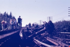
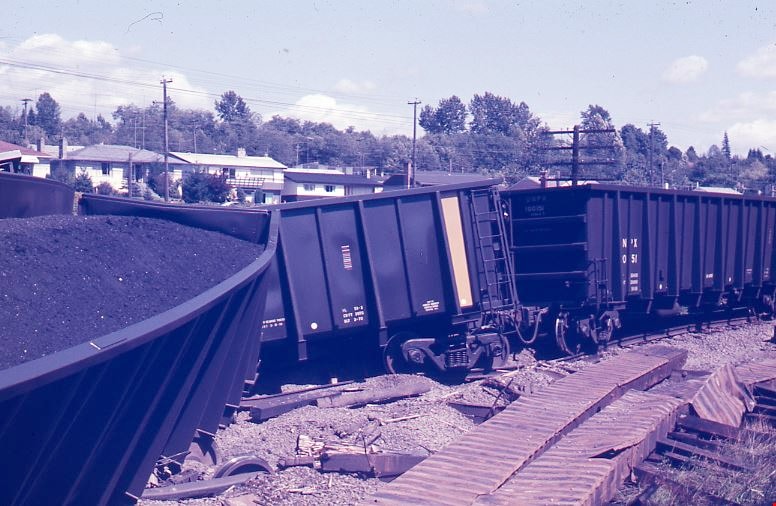
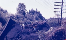
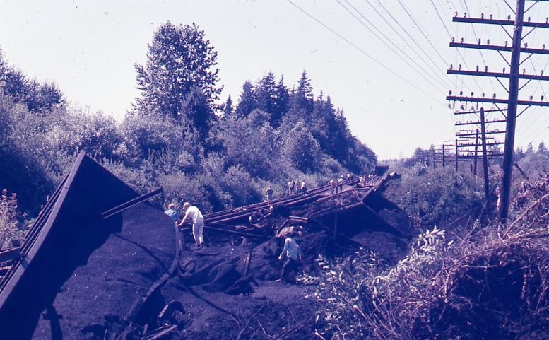
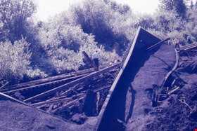
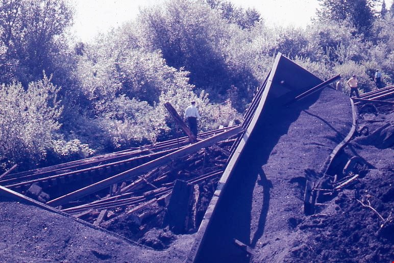
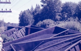
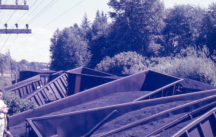
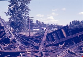
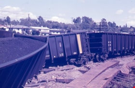
Train wreck at Kensington Avenue
https://search.heritageburnaby.ca/link/museumdescription4306
- Repository
- Burnaby Village Museum
- Date
- 16 Aug. 1970
- Collection/Fonds
- Burnaby Village Museum Photograph collection
- Description Level
- Item
- Physical Description
- 1 photograph : col. ; 35 mm
- Scope and Content
- Photograph of a train wreck at Kensington Avenue and the Lougheed Highway on Aug 16, 1970. The Farmer family was living at Buchanan Street and Holdom Avenue and they heard the train wreck when it happened.
- Repository
- Burnaby Village Museum
- Collection/Fonds
- Burnaby Village Museum Photograph collection
- Description Level
- Item
- Physical Description
- 1 photograph : col. ; 35 mm
- Material Details
- The slide was processed in Canachrome by Mortifee Munshaw.
- Handwritten text in ink on slide frame reads: "Train Wreck / Aug 16 /70".
- Scope and Content
- Photograph of a train wreck at Kensington Avenue and the Lougheed Highway on Aug 16, 1970. The Farmer family was living at Buchanan Street and Holdom Avenue and they heard the train wreck when it happened.
- Names
- Farmer, Joanne
- Geographic Access
- Kensington Avenue
- Lougheed Highway
- Accession Code
- BV017.42.1
- Access Restriction
- No restrictions
- Reproduction Restriction
- No known restrictions
- Date
- 16 Aug. 1970
- Media Type
- Photograph
- Planning Study Area
- Brentwood Area
- Scan Resolution
- 600
- Scan Date
- 05-Jun-2018
- Notes
- Title based on contents of photograph
Images

Train wreck at Kensington Avenue
https://search.heritageburnaby.ca/link/museumdescription4307
- Repository
- Burnaby Village Museum
- Date
- 16 Aug. 1970
- Collection/Fonds
- Burnaby Village Museum Photograph collection
- Description Level
- Item
- Physical Description
- 1 photograph : col. ; 35 mm
- Scope and Content
- Photograph of a train wreck at Kensington Avenue and the Lougheed Highway on Aug 16, 1970. The Farmer family was living at Buchanan Street and Holdom Avenue and they heard the train wreck when it happened.
- Repository
- Burnaby Village Museum
- Collection/Fonds
- Burnaby Village Museum Photograph collection
- Description Level
- Item
- Physical Description
- 1 photograph : col. ; 35 mm
- Material Details
- The slide was processed in Canachrome by Mortifee Munshaw.
- Handwritten text in ink on slide frame reads: "Train Wreck / Aug 16 /70".
- Scope and Content
- Photograph of a train wreck at Kensington Avenue and the Lougheed Highway on Aug 16, 1970. The Farmer family was living at Buchanan Street and Holdom Avenue and they heard the train wreck when it happened.
- Names
- Farmer, Joanne
- Geographic Access
- Kensington Avenue
- Lougheed Highway
- Accession Code
- BV017.42.2
- Access Restriction
- No restrictions
- Reproduction Restriction
- No known restrictions
- Date
- 16 Aug. 1970
- Media Type
- Photograph
- Planning Study Area
- Brentwood Area
- Scan Resolution
- 600
- Scan Date
- 05-Jun-2018
- Notes
- Title based on contents of photograph
Images
Train wreck at Kensington Avenue
https://search.heritageburnaby.ca/link/museumdescription4308
- Repository
- Burnaby Village Museum
- Date
- 16 Aug. 1970
- Collection/Fonds
- Burnaby Village Museum Photograph collection
- Description Level
- Item
- Physical Description
- 1 photograph : col. ; 35 mm
- Scope and Content
- Photograph of a train wreck at Kensington Avenue and the Lougheed Highway on Aug 16, 1970. The Farmer family was living at Buchanan Street and Holdom Avenue and they heard the train wreck when it happened.
- Repository
- Burnaby Village Museum
- Collection/Fonds
- Burnaby Village Museum Photograph collection
- Description Level
- Item
- Physical Description
- 1 photograph : col. ; 35 mm
- Material Details
- The slide was processed in Canachrome by Mortifee Munshaw.
- Handwritten text in ink on slide frame reads: "Train Wreck / Aug 16 /70 / Lougheed Hiway".
- Scope and Content
- Photograph of a train wreck at Kensington Avenue and the Lougheed Highway on Aug 16, 1970. The Farmer family was living at Buchanan Street and Holdom Avenue and they heard the train wreck when it happened.
- Names
- Farmer, Joanne
- Geographic Access
- Kensington Avenue
- Lougheed Highway
- Accession Code
- BV017.42.3
- Access Restriction
- No restrictions
- Reproduction Restriction
- No known restrictions
- Date
- 16 Aug. 1970
- Media Type
- Photograph
- Planning Study Area
- Brentwood Area
- Scan Resolution
- 600
- Scan Date
- 05-Jun-2018
- Notes
- Title based on contents of photograph
Images
Train wreck at Kensington Avenue
https://search.heritageburnaby.ca/link/museumdescription4309
- Repository
- Burnaby Village Museum
- Date
- 16 Aug. 1970
- Collection/Fonds
- Burnaby Village Museum Photograph collection
- Description Level
- Item
- Physical Description
- 1 photograph : col. ; 35 mm
- Scope and Content
- Photograph of a train wreck at Kensington Avenue and the Lougheed Highway on Aug 16, 1970. The Farmer family was living at Buchanan Street and Holdom Avenue and they heard the train wreck when it happened.
- Repository
- Burnaby Village Museum
- Collection/Fonds
- Burnaby Village Museum Photograph collection
- Description Level
- Item
- Physical Description
- 1 photograph : col. ; 35 mm
- Material Details
- The slide was processed in Canachrome by Mortifee Munshaw.
- Handwritten text in ink on slide frame reads: "Train Wreck / Aug 16 /70".
- Scope and Content
- Photograph of a train wreck at Kensington Avenue and the Lougheed Highway on Aug 16, 1970. The Farmer family was living at Buchanan Street and Holdom Avenue and they heard the train wreck when it happened.
- Names
- Farmer, Joanne
- Geographic Access
- Kensington Avenue
- Lougheed Highway
- Accession Code
- BV017.42.4
- Access Restriction
- No restrictions
- Reproduction Restriction
- No known restrictions
- Date
- 16 Aug. 1970
- Media Type
- Photograph
- Planning Study Area
- Brentwood Area
- Scan Resolution
- 600
- Scan Date
- 05-Jun-2018
- Notes
- Title based on contents of photograph
Images
Train wreck at Kensington Avenue
https://search.heritageburnaby.ca/link/museumdescription4310
- Repository
- Burnaby Village Museum
- Date
- 16 Aug. 1970
- Collection/Fonds
- Burnaby Village Museum Photograph collection
- Description Level
- Item
- Physical Description
- 1 photograph : col. ; 35 mm
- Scope and Content
- Photograph of a train wreck at Kensington Avenue and the Lougheed Highway on Aug 16, 1970. The Farmer family was living at Buchanan Street and Holdom Avenue and they heard the train wreck when it happened.
- Repository
- Burnaby Village Museum
- Collection/Fonds
- Burnaby Village Museum Photograph collection
- Description Level
- Item
- Physical Description
- 1 photograph : col. ; 35 mm
- Material Details
- The slide was processed in Canachrome by Mortifee Munshaw.
- Handwritten text in ink on slide frame reads: "Train Wreck / Aug 16 /70".
- Scope and Content
- Photograph of a train wreck at Kensington Avenue and the Lougheed Highway on Aug 16, 1970. The Farmer family was living at Buchanan Street and Holdom Avenue and they heard the train wreck when it happened.
- Names
- Farmer, Joanne
- Geographic Access
- Kensington Avenue
- Lougheed Highway
- Accession Code
- BV017.42.5
- Access Restriction
- No restrictions
- Reproduction Restriction
- No known restrictions
- Date
- 16 Aug. 1970
- Media Type
- Photograph
- Planning Study Area
- Brentwood Area
- Scan Resolution
- 600
- Scan Date
- 05-Jun-2018
- Notes
- Title based on contents of photograph
Images

Train wreck at Kensington Avenue
https://search.heritageburnaby.ca/link/museumdescription4311
- Repository
- Burnaby Village Museum
- Date
- 16 Aug. 1970
- Collection/Fonds
- Burnaby Village Museum Photograph collection
- Description Level
- Item
- Physical Description
- 1 photograph : col. ; 35 mm
- Scope and Content
- Photograph of a train wreck at Kensington Avenue and the Lougheed Highway on Aug 16, 1970. The Farmer family was living at Buchanan Street and Holdom Avenue and they heard the train wreck when it happened.
- Repository
- Burnaby Village Museum
- Collection/Fonds
- Burnaby Village Museum Photograph collection
- Description Level
- Item
- Physical Description
- 1 photograph : col. ; 35 mm
- Material Details
- The slide was processed in Canachrome by Mortifee Munshaw.
- Handwritten text in ink on slide frame reads: "Train Wreck / Aug 16 /70".
- Scope and Content
- Photograph of a train wreck at Kensington Avenue and the Lougheed Highway on Aug 16, 1970. The Farmer family was living at Buchanan Street and Holdom Avenue and they heard the train wreck when it happened.
- Names
- Farmer, Joanne
- Geographic Access
- Kensington Avenue
- Lougheed Highway
- Accession Code
- BV017.42.6
- Access Restriction
- No restrictions
- Reproduction Restriction
- No known restrictions
- Date
- 16 Aug. 1970
- Media Type
- Photograph
- Planning Study Area
- Brentwood Area
- Scan Resolution
- 600
- Scan Date
- 05-Jun-2018
- Notes
- Title based on contents of photograph
Images