Narrow Results By
1946 Data Report (supplement) - Burnaby Town Planning Commission
https://search.heritageburnaby.ca/link/archivedescription8844
- Repository
- City of Burnaby Archives
- Date
- 1946
- Collection/Fonds
- Planning Department fonds
- Description Level
- Item
- Physical Description
- Textual record and cartographic material
- Scope and Content
- This data report also contains a supplemental folder of maps.
- Repository
- City of Burnaby Archives
- Date
- 1946
- Collection/Fonds
- Planning Department fonds
- Series
- Planning General series
- Physical Description
- Textual record and cartographic material
- Description Level
- Item
- Record No.
- 11805
- Accession Number
- 2003-17
- Scope and Content
- This data report also contains a supplemental folder of maps.
- Media Type
- Textual Record
- Cartographic Material
Insurance Plan of the Municipality of Burnaby, B.C. Volume 1
https://search.heritageburnaby.ca/link/archivedescription71903
- Repository
- City of Burnaby Archives
- Date
- March 1964
- Collection/Fonds
- Planning Department fonds
- Description Level
- Item
- Physical Description
- 1 plan : col. ; both sides ; on 39 sheets 33 x 30 cm
- Scope and Content
- Item is volume one of the fire insurance plan for the Municipality of Burnaby for 1963, updated to 1964. This item was collected by the Burnaby Planning Department for information purposes. The Fire Insurance plans cover areas east of Boundary Road and west of Gilley Avenue with Burrard Inlet to th…
- Repository
- City of Burnaby Archives
- Date
- March 1964
- Collection/Fonds
- Planning Department fonds
- Series
- Planning General series
- Physical Description
- 1 plan : col. ; both sides ; on 39 sheets 33 x 30 cm
- Material Details
- Scale : 1 inch = 1200 feet
- Description Level
- Item
- Record No.
- 46225
- Accession Number
- 2012-15
- Scope and Content
- Item is volume one of the fire insurance plan for the Municipality of Burnaby for 1963, updated to 1964. This item was collected by the Burnaby Planning Department for information purposes. The Fire Insurance plans cover areas east of Boundary Road and west of Gilley Avenue with Burrard Inlet to the north and the Fraser River to the south.
- Media Type
- Cartographic Material
- Publisher
- Toronto, Ontario : Underwriters Survey Bureau
- Notes
- Transcribed title
Lougheed Town Centre Plan Map
https://search.heritageburnaby.ca/link/archivedescription56654
- Repository
- City of Burnaby Archives
- Date
- 1997
- Collection/Fonds
- Planning Department fonds
- Description Level
- Item
- Physical Description
- 1 map
- Scope and Content
- Map shows the land use concept and design plan for the Lougheed Town Centre.
- Repository
- City of Burnaby Archives
- Date
- 1997
- Collection/Fonds
- Planning Department fonds
- Physical Description
- 1 map
- Description Level
- Item
- Record No.
- 40080
- Accession Number
- 2008-16
- Scope and Content
- Map shows the land use concept and design plan for the Lougheed Town Centre.
- Media Type
- Textual Record
- Cartographic Material
Lower Mainland Regional Plan
https://search.heritageburnaby.ca/link/archivedescription90139
- Repository
- City of Burnaby Archives
- Date
- 1945
- Collection/Fonds
- Planning Department fonds
- Description Level
- Item
- Physical Description
- 7 maps : col. ; 22.5 x 53.5 cm on sheets 42 x 65 cm
- Scope and Content
- A collection of seven maps titled "Lower Mainland Regional Plan". Maps are numbered and subtitled as: "Light and Power Distribution / Map No. 5"; "Harbour Areas" / Map No. 8"; "Land Use" / Map No. 2"; "Water Supply" / Map No. 6"; "Dykes" / Map No. 7"; "Population Distribution / Map_No._1". All maps…
- Repository
- City of Burnaby Archives
- Date
- 1945
- Collection/Fonds
- Planning Department fonds
- Series
- Planning General series
- Physical Description
- 7 maps : col. ; 22.5 x 53.5 cm on sheets 42 x 65 cm
- Material Details
- Scale : in miles
- Map no. 4 is missing
- Description Level
- Item
- Record No.
- 59929
- Access Restriction
- Open access
- Accession Number
- 2016-09
- Scope and Content
- A collection of seven maps titled "Lower Mainland Regional Plan". Maps are numbered and subtitled as: "Light and Power Distribution / Map No. 5"; "Harbour Areas" / Map No. 8"; "Land Use" / Map No. 2"; "Water Supply" / Map No. 6"; "Dykes" / Map No. 7"; "Population Distribution / Map_No._1". All maps have are marked with boundaries, and landmarks including Historical Monuments, Custom Ports, Airports and Railways.
- Media Type
- Cartographic Material
- Notes
- Transcribed title
- Credit on maps read as: "Bureau_of_Post_War / Rehabilitation_and_Reconstruction / Regional_Planning_Design / Parliament_Buildings_Victoria_BC / Date_Sept_1st_1945 / (signed by ) [A.G._Graham]"
Operation Mink Farm
https://search.heritageburnaby.ca/link/archivedescription72207
- Repository
- City of Burnaby Archives
- Date
- April 24, 1955
- Collection/Fonds
- Planning Department fonds
- Description Level
- Item
- Physical Description
- 1 film reel ( 6 min., 8 sec.) : col. , si. ; 16 mm
- Scope and Content
- Item consists of a silent motion picture civil defense film entitled, "Operation Mink Farm" produced by the Corporation of the District of Burnaby. The film footage was shot in Burnaby, B.C. on April 24th, 1955. A resolution was passed in February 1955 by the Corporation of the District of Burnaby …
- Repository
- City of Burnaby Archives
- Date
- April 24, 1955
- Collection/Fonds
- Planning Department fonds
- Physical Description
- 1 film reel ( 6 min., 8 sec.) : col. , si. ; 16 mm
- Description Level
- Item
- Record No.
- 566-001
- Access Restriction
- No restrictions
- Reproduction Restriction
- No known restrictions
- Accession Number
- 2009-08
- Scope and Content
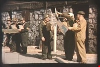
- Item consists of a silent motion picture civil defense film entitled, "Operation Mink Farm" produced by the Corporation of the District of Burnaby. The film footage was shot in Burnaby, B.C. on April 24th, 1955. A resolution was passed in February 1955 by the Corporation of the District of Burnaby to create a Civil Defense Board comprised of council members and appointees, whereby the Reeve would act as the chair of the board. Several municipal employees and council members went through Civil Defense training in preparation for an attack or catastrophe. The first portion of the film takes place at the old City Hall (the stone building) with uniformed Air Raid Precaution (A.R.P.) members performing civil defense exercises in the case of a nuclear war and how to care for and rescue injured civilians. Volunteers pose as the injured as they are cared for and transported on stretchers. In the second portion of the film, the local fire department and civil defense members endeavor to get a fire under control with water hoses. The film takes place at a former mink farm in North Burnaby as referred to in the title.
- Media Type
- Moving Images
- Photographer
- Scott, A.F.
- Notes
- Transcribed title
Images

Video
Operation Mink Farm, April 24, 1955
Operation Mink Farm, April 24, 1955
https://search.heritageburnaby.ca/media/hpo/_Data/_Archives_Moving_Images/_Unrestricted/566-001.m4vProvincial Prison Farm - Oakalla - Plan Showing Central Areas of the Property / Planning Department
https://search.heritageburnaby.ca/link/archivedescription6015
- Repository
- City of Burnaby Archives
- Date
- 1954
- Collection/Fonds
- Planning Department fonds
- Description Level
- Item
- Physical Description
- 1 plan : b&w ink on paper ; 148 x 92 cm folded to 39 x 23 cm
- Scope and Content
- One large plan of Oakalla and the surrounding areas, Plan no. 4436-1.
- Repository
- City of Burnaby Archives
- Date
- 1954
- Collection/Fonds
- Planning Department fonds
- Series
- Facilities series
- Physical Description
- 1 plan : b&w ink on paper ; 148 x 92 cm folded to 39 x 23 cm
- Material Details
- Scale : 1 inch = 50 feet
- Description Level
- Item
- Record No.
- 8966
- Accession Number
- 2001-02
- Scope and Content
- One large plan of Oakalla and the surrounding areas, Plan no. 4436-1.
- Media Type
- Cartographic Material
Traffic Flow Map of Greater Vancouver
https://search.heritageburnaby.ca/link/archivedescription90140
- Repository
- City of Burnaby Archives
- Date
- 1959
- Collection/Fonds
- Planning Department fonds
- Description Level
- Item
- Physical Description
- 1 map : col ; 53 x 82.5 cm on sheet 47 x 86 cm
- Scope and Content
- Map laying out traffic flow of Greater Vancouver Regional District which includes Burnaby.
- Repository
- City of Burnaby Archives
- Date
- 1959
- Collection/Fonds
- Planning Department fonds
- Series
- Planning General series
- Physical Description
- 1 map : col ; 53 x 82.5 cm on sheet 47 x 86 cm
- Material Details
- Scale : 1 inch = .57 miles
- Description Level
- Item
- Record No.
- 59930
- Access Restriction
- Open access
- Accession Number
- 2016-09
- Scope and Content
- Map laying out traffic flow of Greater Vancouver Regional District which includes Burnaby.
- Media Type
- Cartographic Material
- Publisher
- Prepared for Neon Products of Canada Ltd.
- Notes
- Transcribed title