Narrow Results By
Subject
- Aerial Photographs 1
- Agriculture - Farms 3
- Agriculture - Fruit and Berries 1
- Agriculture - Orchards 1
- Animals - Cows 2
- Animals - Dogs 1
- Animals - Poultry 2
- Buildings - Civic - Hospitals 11
- Buildings - Commercial - Train Stations 1
- Buildings - Heritage 108
- Buildings - Residential - Houses 23
- Clothing - Uniforms 3
Person / Organization
- Barnes, Hannah Victoria "Girlie" Love 9
- Boy Scouts of Canada 1
- Brandrith, Benjamin Jefferson "Ben" 3
- Brandrith, Martha Dorothy “Dot” Love 14
- British Columbia Electric Railway Company 2
- Burnett, Geoffrey K. 2
- Clayton, Edith Annie Whiting 4
- Deacon, Charles 2
- Feedham, Phoebe Leonard Love 5
- Feedham, William Charles 1
- George Derby Health Centre 14
- Guppy, Jack 2

A generation of Love
https://search.heritageburnaby.ca/link/museumdescription18827
- Repository
- Burnaby Village Museum
- Date
- 27 Nov 1971
- Collection/Fonds
- Love family fonds
- Description Level
- Item
- Physical Description
- 1 photograph : b&w ; 15 x 21.5 cm
- Scope and Content
- Photograph of members of the Love family wearing their B.C. Centennial medallions identified from left to right; George R. Love, Martha "Dot" (Love) Brandrith, Esther (Love) Stanley, Phoebe (Love) Feedham, Sarah (Love) Parker and Edith "Minnie" (Love) McKenzie. Photograph appeared in the Province n…
- Repository
- Burnaby Village Museum
- Collection/Fonds
- Love family fonds
- Description Level
- Item
- Physical Description
- 1 photograph : b&w ; 15 x 21.5 cm
- Scope and Content
- Photograph of members of the Love family wearing their B.C. Centennial medallions identified from left to right; George R. Love, Martha "Dot" (Love) Brandrith, Esther (Love) Stanley, Phoebe (Love) Feedham, Sarah (Love) Parker and Edith "Minnie" (Love) McKenzie. Photograph appeared in the Province newspaper on November 27, 1971.
- Names
- Love, George Richard
- Brandrith, Martha Dorothy “Dot” Love
- Stanley, Esther Love
- Feedham, Phoebe Leonard Love
- McKenzie, Edith Minnie Love
- Parker, Sarah Maria Love
- Geographic Access
- Cumberland Street
- Street Address
- 7651 Cumberland Street
- Accession Code
- BV019.8.11
- Access Restriction
- No restrictions
- Reproduction Restriction
- No known restrictions
- Date
- 27 Nov 1971
- Media Type
- Photograph
- Historic Neighbourhood
- East Burnaby (Historic Neighbourhood)
- Planning Study Area
- Cariboo-Armstrong Area
- Scan Resolution
- 600
- Scan Date
- 2022-07-07
- Photographer
- Jones, Charles Spurgeon "Chuck"
- Notes
- Title based on contents of photograph
- Handwritten text on label attached to the back reads: "A. GENERATION OF LOVE / Wearing their B.C. Centennial medallions are six members of / the same family, who have all lived in B.C. prior to 1896. / From left are George R. Love 91 Mrs Martha Brandrith 82 / Mrs F C (Esther) Stanley 75 Mrs Phoebe Feedham 77 / Mrs Sarah Parker 79 Mrs Minnie MacKenzie 86 / Date Picture taken Nov 27. 1971".
- Stamped on the back: "CHUCK JONES / PROVINCE PHOTO".
Images

![Albert Parker with dog, [between 1930 and 1940] (date of original), copied 1998 thumbnail](/media/hpo/_Data/_BVM_Images/2018/2018_0041_0170_001.jpg?width=280)
Albert Parker with dog
https://search.heritageburnaby.ca/link/museumdescription9985
- Repository
- Burnaby Village Museum
- Date
- [between 1930 and 1940] (date of original), copied 1998
- Collection/Fonds
- Burnaby Village Museum fonds
- Description Level
- Item
- Physical Description
- 1 photograph : sepia print ; 13 x 9.5 cm
- Scope and Content
- Photograph of young Albert Parker sitting on the ground with a dog. Behind him is the barn with a model "T" Ford parked inside. Albert is wearing a newsboy cap and is holding a black dog between his knees. In 1928 after Sarah Parker's father, Jesse Love died, William and Sarah (nee Love) Parker pu…
- Repository
- Burnaby Village Museum
- Collection/Fonds
- Burnaby Village Museum fonds
- Series
- Jesse Love farmhouse series
- Subseries
- Love family photographs subseries
- Description Level
- Item
- Physical Description
- 1 photograph : sepia print ; 13 x 9.5 cm
- Scope and Content
- Photograph of young Albert Parker sitting on the ground with a dog. Behind him is the barn with a model "T" Ford parked inside. Albert is wearing a newsboy cap and is holding a black dog between his knees. In 1928 after Sarah Parker's father, Jesse Love died, William and Sarah (nee Love) Parker purchased the Love farmhouse located at 1390 Cumberland Road. They lived there until 1961, with their three children; Albert, Bill and Elsie.
- Subjects
- Buildings - Heritage
- Geographic Access
- Cumberland Street
- Street Address
- 7651 Cumberland Street
- Accession Code
- BV018.41.170
- Access Restriction
- No restrictions
- Reproduction Restriction
- May be restricted by third party rights
- Date
- [between 1930 and 1940] (date of original), copied 1998
- Media Type
- Photograph
- Historic Neighbourhood
- East Burnaby (Historic Neighbourhood)
- Planning Study Area
- Cariboo-Armstrong Area
- Scan Resolution
- 600
- Scan Date
- 25-Feb-2019
- Scale
- 100
- Notes
- Title based on contents of photograph
Images
![Albert Parker with dog, [between 1930 and 1940] (date of original), copied 1998 thumbnail](/media/hpo/_Data/_BVM_Images/2018/2018_0041_0170_001.jpg)
![Bea Carpenter, [1951 or 1952] (date of original), copied 1991 thumbnail](/media/hpo/_Data/_Archives_Images/_Unrestricted/370/370-122.jpg?width=280)
Bea Carpenter
https://search.heritageburnaby.ca/link/archivedescription37534
- Repository
- City of Burnaby Archives
- Date
- [1951 or 1952] (date of original), copied 1991
- Collection/Fonds
- Burnaby Historical Society fonds
- Description Level
- Item
- Physical Description
- 1 photograph : b&w ; 2.8 x 3.8 cm print on contact sheet 20.2 x 25.3 cm
- Scope and Content
- Photograph of Bea Carpenter standing beside a car (a 1950 Studebaker) in front of the George Derby Health Centre. She wearing her nurse's uniform.
- Repository
- City of Burnaby Archives
- Date
- [1951 or 1952] (date of original), copied 1991
- Collection/Fonds
- Burnaby Historical Society fonds
- Subseries
- Burnaby Image Bank subseries
- Physical Description
- 1 photograph : b&w ; 2.8 x 3.8 cm print on contact sheet 20.2 x 25.3 cm
- Description Level
- Item
- Record No.
- 370-122
- Access Restriction
- No restrictions
- Reproduction Restriction
- No restrictions
- Accession Number
- BHS1999-03
- Scope and Content
- Photograph of Bea Carpenter standing beside a car (a 1950 Studebaker) in front of the George Derby Health Centre. She wearing her nurse's uniform.
- Media Type
- Photograph
- Notes
- Title based on contents of photograph
- 1 b&w copy negative accompanying
- Geographic Access
- Cumberland Street
- Street Address
- 7550 Cumberland Street
- Historic Neighbourhood
- East Burnaby (Historic Neighbourhood)
- Planning Study Area
- Cariboo-Armstrong Area
Images
![Bea Carpenter, [1951 or 1952] (date of original), copied 1991 thumbnail](/media/hpo/_Data/_Archives_Images/_Unrestricted/370/370-122.jpg)

Bea Carpenter
https://search.heritageburnaby.ca/link/archivedescription37535
- Repository
- City of Burnaby Archives
- Date
- April 10, 1947 (date of original), copied 1991
- Collection/Fonds
- Burnaby Historical Society fonds
- Description Level
- Item
- Physical Description
- 1 photograph : b&w ; 3.7 x 3.1 cm print on contact sheet 20.2 x 25.3 cm
- Scope and Content
- Photograph of Bea Carpenter in the driveway of the George Derby Health Centre on opening day. She is in her nurses uniform and carrying flowers.
- Repository
- City of Burnaby Archives
- Date
- April 10, 1947 (date of original), copied 1991
- Collection/Fonds
- Burnaby Historical Society fonds
- Subseries
- Burnaby Image Bank subseries
- Physical Description
- 1 photograph : b&w ; 3.7 x 3.1 cm print on contact sheet 20.2 x 25.3 cm
- Description Level
- Item
- Record No.
- 370-123
- Access Restriction
- No restrictions
- Reproduction Restriction
- No known restrictions
- Accession Number
- BHS1999-03
- Scope and Content
- Photograph of Bea Carpenter in the driveway of the George Derby Health Centre on opening day. She is in her nurses uniform and carrying flowers.
- Media Type
- Photograph
- Notes
- Title based on contents of photograph
- 1 b&w copy negative accompanying
- Geographic Access
- Cumberland Street
- Street Address
- 7550 Cumberland Street
- Historic Neighbourhood
- East Burnaby (Historic Neighbourhood)
- Planning Study Area
- Cariboo-Armstrong Area
Images


Bea Carpenter
https://search.heritageburnaby.ca/link/archivedescription37536
- Repository
- City of Burnaby Archives
- Date
- 1947 (date of original), copied 1991
- Collection/Fonds
- Burnaby Historical Society fonds
- Description Level
- Item
- Physical Description
- 1 photograph : b&w ; 3.0 x 4.5 cm print on contact sheet 20.2 x 25.3 cm
- Scope and Content
- Photograph of Bea Carpenter in her nurses uniform with the George Derby Health Centre in the background.
- Repository
- City of Burnaby Archives
- Date
- 1947 (date of original), copied 1991
- Collection/Fonds
- Burnaby Historical Society fonds
- Subseries
- Burnaby Image Bank subseries
- Physical Description
- 1 photograph : b&w ; 3.0 x 4.5 cm print on contact sheet 20.2 x 25.3 cm
- Description Level
- Item
- Record No.
- 370-124
- Access Restriction
- No restrictions
- Reproduction Restriction
- No known restrictions
- Accession Number
- BHS1999-03
- Scope and Content
- Photograph of Bea Carpenter in her nurses uniform with the George Derby Health Centre in the background.
- Media Type
- Photograph
- Notes
- Title based on contents of photograph
- 1 b&w copy negative accompanying
- Geographic Access
- Cumberland Street
- Street Address
- 7550 Cumberland Street
- Historic Neighbourhood
- East Burnaby (Historic Neighbourhood)
- Planning Study Area
- Cariboo-Armstrong Area
Images

![Bob Love, [191-] thumbnail](/media/hpo/_Data/_BVM_Images/2022/2022_0032_0134_001.jpg?width=280)
Bob Love
https://search.heritageburnaby.ca/link/museumdescription19712
- Repository
- Burnaby Village Museum
- Date
- [191-]
- Collection/Fonds
- Esther Love Stanley fonds
- Description Level
- Item
- Physical Description
- 1 photograph : b&w ; 10.5 x 8 cm
- Scope and Content
- Photograph of Thomas Robert "Bob" Love, standing in an orchard at the Love family home at 1390 Cumberland Road. Bob's right arm is bent with his hand on his waist. He is wearing a white collared shirt with tie, dark pants, belt and suspenders. Orchard trees in full leaf are in background. Bob Love…
- Repository
- Burnaby Village Museum
- Collection/Fonds
- Esther Love Stanley fonds
- Description Level
- Item
- Physical Description
- 1 photograph : b&w ; 10.5 x 8 cm
- Scope and Content
- Photograph of Thomas Robert "Bob" Love, standing in an orchard at the Love family home at 1390 Cumberland Road. Bob's right arm is bent with his hand on his waist. He is wearing a white collared shirt with tie, dark pants, belt and suspenders. Orchard trees in full leaf are in background. Bob Love served in World War 1 and died at the age of 31 years on November 23, 1918.
- Geographic Access
- Cumberland Street
- Street Address
- 7651 Cumberland Street
- Accession Code
- BV022.32.134
- Access Restriction
- No restrictions
- Reproduction Restriction
- No known restrictions
- Date
- [191-]
- Media Type
- Photograph
- Historic Neighbourhood
- East Burnaby (Historic Neighbourhood)
- Planning Study Area
- Cariboo-Armstrong Area
- Related Material
- See also BV022.32.514
- Scan Resolution
- 600
- Scan Date
- 2023-04-04
- Notes
- Title based on contents of photograph
- Photograph is part of Esther Love Stanley photograph album 1 (BV022.32.1)
- Note in white ink on album page reads: "BOB"
Images
![Bob Love, [191-] thumbnail](/media/hpo/_Data/_BVM_Images/2022/2022_0032_0134_001.jpg)
![Bob Love on porch, [191-] thumbnail](/media/hpo/_Data/_BVM_Images/2022/2022_0032_0162_001.jpg?width=280)
Bob Love on porch
https://search.heritageburnaby.ca/link/museumdescription19740
- Repository
- Burnaby Village Museum
- Date
- [191-]
- Collection/Fonds
- Esther Love Stanley fonds
- Description Level
- Item
- Physical Description
- 1 photograph : b&w ; 8 x 10.5 cm
- Scope and Content
- Photograph of Thomas Robert "Bob" Love standing on the front porch of the Love family home on Cumberland Road.
- Repository
- Burnaby Village Museum
- Collection/Fonds
- Esther Love Stanley fonds
- Description Level
- Item
- Physical Description
- 1 photograph : b&w ; 8 x 10.5 cm
- Scope and Content
- Photograph of Thomas Robert "Bob" Love standing on the front porch of the Love family home on Cumberland Road.
- Geographic Access
- Cumberland Street
- Street Address
- 7651 Cumberland Street
- Accession Code
- BV022.32.162
- Access Restriction
- No restrictions
- Reproduction Restriction
- No known restrictions
- Date
- [191-]
- Media Type
- Photograph
- Historic Neighbourhood
- East Burnaby (Historic Neighbourhood)
- Planning Study Area
- Cariboo-Armstrong Area
- Scan Resolution
- 600
- Scan Date
- 2023-04-04
- Notes
- Title based on contents of photograph
- Photograph is part of Esther Love Stanley photograph album 1 (BV022.32.1)
- Annotation in white on album page reads: "Bob"
Images
![Bob Love on porch, [191-] thumbnail](/media/hpo/_Data/_BVM_Images/2022/2022_0032_0162_001.jpg)
![Bob or Henry Love on porch, [191-] thumbnail](/media/hpo/_Data/_BVM_Images/2022/2022_0032_0154_001.jpg?width=280)
Bob or Henry Love on porch
https://search.heritageburnaby.ca/link/museumdescription19732
- Repository
- Burnaby Village Museum
- Date
- [191-]
- Collection/Fonds
- Esther Love Stanley fonds
- Description Level
- Item
- Physical Description
- 1 photograph : b&w ; 10.5 x 8 cm
- Scope and Content
- Photograph of Henry or Bob Love standing on the front porch of the Love family home on Cumberland Road.
- Repository
- Burnaby Village Museum
- Collection/Fonds
- Esther Love Stanley fonds
- Description Level
- Item
- Physical Description
- 1 photograph : b&w ; 10.5 x 8 cm
- Scope and Content
- Photograph of Henry or Bob Love standing on the front porch of the Love family home on Cumberland Road.
- Geographic Access
- Cumberland Street
- Street Address
- 7651 Cumberland Street
- Accession Code
- BV022.32.154
- Access Restriction
- No restrictions
- Reproduction Restriction
- No known restrictions
- Date
- [191-]
- Media Type
- Photograph
- Historic Neighbourhood
- East Burnaby (Historic Neighbourhood)
- Planning Study Area
- Cariboo-Armstrong Area
- Scan Resolution
- 600
- Scan Date
- 2023-04-04
- Notes
- Title based on contents of photograph
- Photograph is part of Esther Love Stanley photograph album 1 (BV022.32.1)
Images
![Bob or Henry Love on porch, [191-] thumbnail](/media/hpo/_Data/_BVM_Images/2022/2022_0032_0154_001.jpg)

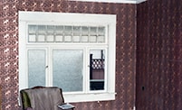
B room, northeast view and window
https://search.heritageburnaby.ca/link/museumdescription10769
- Repository
- Burnaby Village Museum
- Date
- May 12, 1988
- Collection/Fonds
- Burnaby Village Museum fonds
- Description Level
- Item
- Physical Description
- 1 photograph : b&w negative ; 35 mm
- Scope and Content
- Photograph of northeast view and window in room "B", upstairs in the Love farmhouse while it was located at 7651 Cumberland Street (the corner of 14th Avenue and Cumberland Street).
- Repository
- Burnaby Village Museum
- Collection/Fonds
- Burnaby Village Museum fonds
- Series
- Jesse Love farmhouse series
- Description Level
- Item
- Physical Description
- 1 photograph : b&w negative ; 35 mm
- Material Details
- Photograph is part of Film roll "D" - 37 b&w photographs that are a part of a collection described as BV018.41.82
- Scope and Content
- Photograph of northeast view and window in room "B", upstairs in the Love farmhouse while it was located at 7651 Cumberland Street (the corner of 14th Avenue and Cumberland Street).
- Subjects
- Buildings - Heritage
- Geographic Access
- Cumberland Street
- Street Address
- 7651 Cumberland Street
- Accession Code
- BV018.41.292
- Access Restriction
- No restrictions
- Reproduction Restriction
- No known restrictions
- Date
- May 12, 1988
- Media Type
- Photograph
- Historic Neighbourhood
- East Burnaby (Historic Neighbourhood)
- Planning Study Area
- Cariboo-Armstrong Area
- Related Material
- See BV018.41.82 for File Level Description
- Scan Resolution
- 2400
- Scan Date
- 13-May-19
- Scale
- 100
- Photographer
- Wolf, Jim
- Notes
- Title based on contents of photograph
- Photograph is a part of file level description "Photographic documentation of changes and move" BV018.41.82
Images


B room, northwest corner and bathtub
https://search.heritageburnaby.ca/link/museumdescription10770
- Repository
- Burnaby Village Museum
- Date
- May 12, 1988
- Collection/Fonds
- Burnaby Village Museum fonds
- Description Level
- Item
- Physical Description
- 1 photograph : b&w negative ; 35 mm
- Scope and Content
- Photograph of the northwest corner and bathtub in room "B", upstairs in the Love farmhouse while it was located at 7651 Cumberland Street (the corner of 14th Avenue and Cumberland Street).
- Repository
- Burnaby Village Museum
- Collection/Fonds
- Burnaby Village Museum fonds
- Series
- Jesse Love farmhouse series
- Description Level
- Item
- Physical Description
- 1 photograph : b&w negative ; 35 mm
- Material Details
- Photograph is part of Film roll "D" - 37 b&w photographs that are a part of a collection described as BV018.41.82
- Scope and Content
- Photograph of the northwest corner and bathtub in room "B", upstairs in the Love farmhouse while it was located at 7651 Cumberland Street (the corner of 14th Avenue and Cumberland Street).
- Subjects
- Buildings - Heritage
- Geographic Access
- Cumberland Street
- Street Address
- 7651 Cumberland Street
- Accession Code
- BV018.41.293
- Access Restriction
- No restrictions
- Reproduction Restriction
- No known restrictions
- Date
- May 12, 1988
- Media Type
- Photograph
- Historic Neighbourhood
- East Burnaby (Historic Neighbourhood)
- Planning Study Area
- Cariboo-Armstrong Area
- Related Material
- See BV018.41.82 for File Level Description
- Scan Resolution
- 2400
- Scan Date
- 13-May-19
- Scale
- 100
- Photographer
- Wolf, Jim
- Notes
- Title based on contents of photograph
- Photograph is a part of file level description "Photographic documentation of changes and move" BV018.41.82
Images


Burnaby Lake Interurban line
https://search.heritageburnaby.ca/link/archivedescription36810
- Repository
- City of Burnaby Archives
- Date
- 1926 (date of original), copied 1992
- Collection/Fonds
- Burnaby Historical Society fonds
- Description Level
- Item
- Physical Description
- 1 photograph : b&w ; 7.0 x 12.7 cm print
- Scope and Content
- Photograph of a tram on the Burnaby Lake Interurban line at the Cumberland Road station.
- Repository
- City of Burnaby Archives
- Date
- 1926 (date of original), copied 1992
- Collection/Fonds
- Burnaby Historical Society fonds
- Subseries
- Burnaby Centennial Anthology subseries
- Physical Description
- 1 photograph : b&w ; 7.0 x 12.7 cm print
- Description Level
- Item
- Record No.
- 315-268
- Access Restriction
- No restrictions
- Reproduction Restriction
- No known restrictions
- Accession Number
- BHS1994-04
- Scope and Content
- Photograph of a tram on the Burnaby Lake Interurban line at the Cumberland Road station.
- Media Type
- Photograph
- Notes
- Title based on contents of photograph
- Geographic Access
- Cumberland Street
- Burnaby Lake Interurban line
- Historic Neighbourhood
- East Burnaby (Historic Neighbourhood)
- Planning Study Area
- Cariboo-Armstrong Area
Images


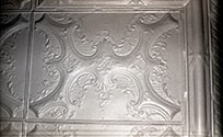
Ceiling in parlour
https://search.heritageburnaby.ca/link/museumdescription10812
- Repository
- Burnaby Village Museum
- Date
- April 8, 1988
- Collection/Fonds
- Burnaby Village Museum fonds
- Description Level
- Item
- Physical Description
- 1 photograph : col. negative ; 35 mm
- Scope and Content
- Photograph of the tin ceiling in the parlour inside of the Love farmhouse while it was located at 7651 Cumberland Street (the corner of 14th Avenue and Cumberland Street). The photograph was taken of the house once it was saved and acquired by the Burnaby Village Museum.
- Repository
- Burnaby Village Museum
- Collection/Fonds
- Burnaby Village Museum fonds
- Series
- Jesse Love farmhouse series
- Description Level
- Item
- Physical Description
- 1 photograph : col. negative ; 35 mm
- Material Details
- Photograph is part of Film roll "F" - 23 colour photographs that are a part of a collection described as BV018.41.82
- Scope and Content
- Photograph of the tin ceiling in the parlour inside of the Love farmhouse while it was located at 7651 Cumberland Street (the corner of 14th Avenue and Cumberland Street). The photograph was taken of the house once it was saved and acquired by the Burnaby Village Museum.
- Subjects
- Buildings - Heritage
- Geographic Access
- Cumberland Street
- Street Address
- 7651 Cumberland Street
- Accession Code
- BV018.41.334
- Access Restriction
- No restrictions
- Reproduction Restriction
- No known restrictions
- Date
- April 8, 1988
- Media Type
- Photograph
- Historic Neighbourhood
- East Burnaby (Historic Neighbourhood)
- Planning Study Area
- Cariboo-Armstrong Area
- Related Material
- See BV018.41.82 for File Level Description
- Scan Resolution
- 2400
- Scan Date
- 13-May-19
- Scale
- 100
- Photographer
- Wolf, Jim
- Notes
- Title based on contents of photograph
- Photograph is a part of file level description "Photographic documentation of changes and move" BV018.41.82
Images


Cooling cupboard in basement
https://search.heritageburnaby.ca/link/museumdescription10867
- Repository
- Burnaby Village Museum
- Date
- April 11, 1988
- Collection/Fonds
- Burnaby Village Museum fonds
- Description Level
- Item
- Physical Description
- 1 photograph : b&w negative ; 35 mm
- Scope and Content
- Photograph of cooling cupboard in along the wast wall in the basement of the Love farmhouse located at 7651 Cumberland Street (the corner of 14th Avenue and Cumberland Street). The photograph was taken of the house once it was saved and acquired by the Burnaby Village Museum.
- Repository
- Burnaby Village Museum
- Collection/Fonds
- Burnaby Village Museum fonds
- Series
- Jesse Love farmhouse series
- Description Level
- Item
- Physical Description
- 1 photograph : b&w negative ; 35 mm
- Material Details
- Photograph is part of Film roll "H" - 36 b&w photographs that are a part of a collection described as BV018.41.82
- Scope and Content
- Photograph of cooling cupboard in along the wast wall in the basement of the Love farmhouse located at 7651 Cumberland Street (the corner of 14th Avenue and Cumberland Street). The photograph was taken of the house once it was saved and acquired by the Burnaby Village Museum.
- Subjects
- Buildings - Heritage
- Geographic Access
- Cumberland Street
- Street Address
- 7651 Cumberland Street
- Accession Code
- BV018.41.389
- Access Restriction
- No restrictions
- Reproduction Restriction
- No known restrictions
- Date
- April 11, 1988
- Media Type
- Photograph
- Historic Neighbourhood
- East Burnaby (Historic Neighbourhood)
- Planning Study Area
- Cariboo-Armstrong Area
- Related Material
- See BV018.41.82 for File Level Description
- Scan Resolution
- 2400
- Scan Date
- 6/3/2019
- Scale
- 100
- Photographer
- Wolf, Jim
- Notes
- Title based on contents of photograph
- Photograph is a part of file level description "Photographic documentation of changes and move" BV018.41.82
Images

![Corner view of Love farmhouse, [between 1966 and 1970] thumbnail](/media/hpo/_Data/_BVM_Images/2019/2019_0003_0005_001.jpg?width=280)
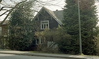
Corner view of Love farmhouse
https://search.heritageburnaby.ca/link/museumdescription9919
- Repository
- Burnaby Village Museum
- Date
- [between 1966 and 1970]
- Collection/Fonds
- Love family fonds
- Description Level
- Item
- Physical Description
- 1 photograph : col. ; 10 x 15 cm print
- Scope and Content
- Photograph of the exterior of the Love farmhouse taken at the corner of Fourteenth Avenue and Cumberland Street. The house is hidden behind large trees at it's orignal address of 7651 Cumberland Street (Address pre 1960: 1390 Cumberland Road). This photograph was taken while Elsie Hughes (nee Love)…
- Repository
- Burnaby Village Museum
- Collection/Fonds
- Love family fonds
- Description Level
- Item
- Physical Description
- 1 photograph : col. ; 10 x 15 cm print
- Material Details
- Copy print was made from re-photographing an original colour slide
- Scope and Content
- Photograph of the exterior of the Love farmhouse taken at the corner of Fourteenth Avenue and Cumberland Street. The house is hidden behind large trees at it's orignal address of 7651 Cumberland Street (Address pre 1960: 1390 Cumberland Road). This photograph was taken while Elsie Hughes (nee Love), her husband John Hughes and son Brent Hughes lived in the house. Elsie is the daughter of Sarah (nee Love) and William Parker. Sarah and William purchased the house in 1928, shortly after the death of Sarah's father, Jesse Love. Sarah and William Parker lived in the house with their three children, Albert, Bill and Elsie. William Parker died in 1961 and Sarah continued to live in the house until 1966 before selling it to her daughter Elsie and son in law John Hughes. Elsie and John lived in the house with their son Brent until 1971.
- Subjects
- Buildings - Heritage
- Geographic Access
- 14th Avenue
- Cumberland Street
- Street Address
- 7651 Cumberland Street
- Accession Code
- BV019.3.5
- Access Restriction
- No restrictions
- Reproduction Restriction
- No known restrictions
- Date
- [between 1966 and 1970]
- Media Type
- Photograph
- Historic Neighbourhood
- East Burnaby (Historic Neighbourhood)
- Planning Study Area
- Cariboo-Armstrong Area
- Scan Resolution
- 600
- Scan Date
- 31-Jan-2019
- Scale
- 96
- Photographer
- Parker, Albert "Bert"
- Notes
- Title based on contents of photograph
- See also BV992.15.12
Images
![Corner view of Love farmhouse, [between 1966 and 1970] thumbnail](/media/hpo/_Data/_BVM_Images/2019/2019_0003_0005_001.jpg)
![Corner view of Love farmhouse, [between 1966 and 1970] thumbnail](/media/hpo/_Data/_BVM_Images/2019/2019_0003_0006_001.jpg?width=280)
Corner view of Love farmhouse
https://search.heritageburnaby.ca/link/museumdescription9920
- Repository
- Burnaby Village Museum
- Date
- [between 1966 and 1970]
- Collection/Fonds
- Love family fonds
- Description Level
- Item
- Physical Description
- 1 photograph : col. ; 10 x 15 cm print
- Scope and Content
- Photograph of the exterior of the Love farmhouse taken at the corner of Fourteenth Avenue and Cumberland Street. The north side of the house and kitchen are in view with large trees covering the front of the house at it's orignal address of 7651 Cumberland Street (Address pre 1960: 1390 Cumberland …
- Repository
- Burnaby Village Museum
- Collection/Fonds
- Love family fonds
- Description Level
- Item
- Physical Description
- 1 photograph : col. ; 10 x 15 cm print
- Material Details
- Copy print was made from re-photographing an original colour slide
- Scope and Content
- Photograph of the exterior of the Love farmhouse taken at the corner of Fourteenth Avenue and Cumberland Street. The north side of the house and kitchen are in view with large trees covering the front of the house at it's orignal address of 7651 Cumberland Street (Address pre 1960: 1390 Cumberland Road). This photograph was taken while Elsie Hughes (nee Love), her husband John Hughes and son Brent Hughes lived in the house. Elsie is the daughter of Sarah (nee Love) and William Parker. Sarah and William purchased the house in 1928, shortly after the death of Sarah's father, Jesse Love. Sarah and William Parker lived in the house with their three children, Albert, Bill and Elsie. William Parker died in 1961 and Sarah continued to live in the house until 1966 before selling it to her daughter Elsie and son in law John Hughes. Elsie and John lived in the house with their son Brent until 1971.
- Subjects
- Buildings - Heritage
- Geographic Access
- 14th Avenue
- Cumberland Street
- Street Address
- 7651 Cumberland Street
- Accession Code
- BV019.3.6
- Access Restriction
- No restrictions
- Reproduction Restriction
- No known restrictions
- Date
- [between 1966 and 1970]
- Media Type
- Photograph
- Historic Neighbourhood
- East Burnaby (Historic Neighbourhood)
- Planning Study Area
- Cariboo-Armstrong Area
- Scan Resolution
- 600
- Scan Date
- 31-Jan-2019
- Scale
- 96
- Photographer
- Parker, Albert "Bert"
- Notes
- Title based on contents of photograph
- See also BV992.15.12
Images
![Corner view of Love farmhouse, [between 1966 and 1970] thumbnail](/media/hpo/_Data/_BVM_Images/2019/2019_0003_0006_001.jpg)

C room north wall and window
https://search.heritageburnaby.ca/link/museumdescription10767
- Repository
- Burnaby Village Museum
- Date
- May 12, 1988
- Collection/Fonds
- Burnaby Village Museum fonds
- Description Level
- Item
- Physical Description
- 1 photograph : b&w negative ; 35 mm
- Scope and Content
- Photograph of the north wall and window in room "C", upstairs in the Love farmhouse while it was located at 7651 Cumberland Street (the corner of 14th Avenue and Cumberland Street).
- Repository
- Burnaby Village Museum
- Collection/Fonds
- Burnaby Village Museum fonds
- Series
- Jesse Love farmhouse series
- Description Level
- Item
- Physical Description
- 1 photograph : b&w negative ; 35 mm
- Material Details
- Photograph is part of Film roll "D" - 37 b&w photographs that are a part of a collection described as BV018.41.82
- Scope and Content
- Photograph of the north wall and window in room "C", upstairs in the Love farmhouse while it was located at 7651 Cumberland Street (the corner of 14th Avenue and Cumberland Street).
- Subjects
- Buildings - Heritage
- Geographic Access
- Cumberland Street
- Street Address
- 7651 Cumberland Street
- Accession Code
- BV018.41.290
- Access Restriction
- No restrictions
- Reproduction Restriction
- No known restrictions
- Date
- May 12, 1988
- Media Type
- Photograph
- Historic Neighbourhood
- East Burnaby (Historic Neighbourhood)
- Planning Study Area
- Cariboo-Armstrong Area
- Related Material
- See BV018.41.82 for File Level Description
- Scan Resolution
- 2400
- Scan Date
- 13-May-19
- Scale
- 100
- Photographer
- Wolf, Jim
- Notes
- Title based on contents of photograph
- Photograph is a part of file level description "Photographic documentation of changes and move" BV018.41.82
Images


Cumberland Road Station on the Burnaby Lake Line
https://search.heritageburnaby.ca/link/museumdescription90
- Repository
- Burnaby Village Museum
- Date
- 1949 (date of original), copied January 1988
- Collection/Fonds
- Burnaby Village Museum Photograph collection
- Description Level
- Item
- Physical Description
- 1 photograph : 19.5 x 24.5 cm print
- Scope and Content
- Photograph of the Cumberland Road Station on the Burnaby Lake Line. The station shelter is on a small, raised platform in a wooded area. Electric power poles are visible running along the tracks.
- Repository
- Burnaby Village Museum
- Collection/Fonds
- Burnaby Village Museum Photograph collection
- Description Level
- Item
- Physical Description
- 1 photograph : 19.5 x 24.5 cm print
- Scope and Content
- Photograph of the Cumberland Road Station on the Burnaby Lake Line. The station shelter is on a small, raised platform in a wooded area. Electric power poles are visible running along the tracks.
- Subjects
- Transportation - Electric Railroads
- Geographic Access
- Cumberland Street
- Accession Code
- BV988.7.8
- Access Restriction
- No restrictions
- Reproduction Restriction
- May be restricted by third party rights
- Date
- 1949 (date of original), copied January 1988
- Media Type
- Photograph
- Scan Resolution
- 600
- Scan Date
- 2024-04-09
- Photographer
- Plant, Ernest Leslie
- Notes
- Title based on contents of photograph
- Note on verso of photograph reads: "Cumberland Rd. Station, Burnaby Lake line, 1949/ Ernie Plant photo from/ the Henry Ewert Collection/ photo produced by/ Robert Bodlak/ 1/88"
Images


Detail of tin ceiling in entrance hallway
https://search.heritageburnaby.ca/link/museumdescription9978
- Repository
- Burnaby Village Museum
- Date
- 1988
- Collection/Fonds
- Burnaby Village Museum fonds
- Description Level
- Item
- Physical Description
- 1 photograph : b&w negative ; 35 mm
- Scope and Content
- Photograph detail of the painted tin ceiling in the entrance hallway of the Love farmhouse. The photograph was taken while the house was still located at 7651 Cumberland Street before being moved to the Burnaby Village Museum in May 1988. The original tin ceiling was restored and painted on the sit…
- Repository
- Burnaby Village Museum
- Collection/Fonds
- Burnaby Village Museum fonds
- Series
- Jesse Love farmhouse series
- Description Level
- Item
- Physical Description
- 1 photograph : b&w negative ; 35 mm
- Scope and Content
- Photograph detail of the painted tin ceiling in the entrance hallway of the Love farmhouse. The photograph was taken while the house was still located at 7651 Cumberland Street before being moved to the Burnaby Village Museum in May 1988. The original tin ceiling was restored and painted on the site of the Burnaby Village Museum.
- Subjects
- Buildings - Heritage
- Geographic Access
- Cumberland Street
- Street Address
- 7651 Cumberland Street
- Accession Code
- BV018.41.165
- Access Restriction
- No restrictions
- Reproduction Restriction
- May be restricted by third party rights
- Date
- 1988
- Media Type
- Photograph
- Historic Neighbourhood
- East Burnaby (Historic Neighbourhood)
- Planning Study Area
- Cariboo-Armstrong Area
- Scan Resolution
- 1000
- Scan Date
- 31-Jan-2019
- Scale
- 100
- Notes
- Title based on contents of photograph
- Photograph is one of a group of 25 photographs that were taken by Jim Wolf (not all photographs were described)
- See BV988.33.34 for description of artifact
Images

Detail of tin ceiling in music room
https://search.heritageburnaby.ca/link/museumdescription10257
- Repository
- Burnaby Village Museum
- Date
- Aug. 28, 1988
- Collection/Fonds
- Burnaby Village Museum fonds
- Description Level
- Item
- Physical Description
- 1 photograph : col. slide ; 35 mm
- Scope and Content
- Photograph detail of the tin ceiling in the Love farmhouse music room (parlour). Photograph was taken prior to the ceiling being restored.
- Repository
- Burnaby Village Museum
- Collection/Fonds
- Burnaby Village Museum fonds
- Series
- Jesse Love farmhouse series
- Description Level
- Item
- Physical Description
- 1 photograph : col. slide ; 35 mm
- Scope and Content
- Photograph detail of the tin ceiling in the Love farmhouse music room (parlour). Photograph was taken prior to the ceiling being restored.
- Subjects
- Buildings - Heritage
- Geographic Access
- Cumberland Street
- Street Address
- 7651 Cumberland Street
- Accession Code
- BV018.41.145
- Access Restriction
- No restrictions
- Reproduction Restriction
- No known restrictions
- Date
- Aug. 28, 1988
- Media Type
- Photograph
- Historic Neighbourhood
- East Burnaby (Historic Neighbourhood)
- Planning Study Area
- Cariboo-Armstrong Area
- Scan Resolution
- 600
- Scan Date
- 24-Feb-19
- Scale
- 96
- Photographer
- Wolf, Jim
- Notes
- Title based on contents of photograph
Images

Detail of tin ceiling tile
https://search.heritageburnaby.ca/link/museumdescription9976
- Repository
- Burnaby Village Museum
- Date
- 1988
- Collection/Fonds
- Burnaby Village Museum fonds
- Description Level
- Item
- Physical Description
- 1 photograph : b&w negative ; 35 mm
- Scope and Content
- Photograph detail of the tin ceiling that was in the parlour of the Love farmhouse. The photograph was taken while the house was still located at 7651 Cumberland Street before being moved to the Burnaby Village Museum in May 1988. The original tin ceiling was restored and painted on the site of th…
- Repository
- Burnaby Village Museum
- Collection/Fonds
- Burnaby Village Museum fonds
- Series
- Jesse Love farmhouse series
- Description Level
- Item
- Physical Description
- 1 photograph : b&w negative ; 35 mm
- Scope and Content
- Photograph detail of the tin ceiling that was in the parlour of the Love farmhouse. The photograph was taken while the house was still located at 7651 Cumberland Street before being moved to the Burnaby Village Museum in May 1988. The original tin ceiling was restored and painted on the site of the Burnaby Village Museum.
- Subjects
- Buildings - Heritage
- Geographic Access
- Cumberland Street
- Street Address
- 7651 Cumberland Street
- Accession Code
- BV018.41.163
- Access Restriction
- No restrictions
- Reproduction Restriction
- May be restricted by third party rights
- Date
- 1988
- Media Type
- Photograph
- Historic Neighbourhood
- East Burnaby (Historic Neighbourhood)
- Planning Study Area
- Cariboo-Armstrong Area
- Scan Resolution
- 1000
- Scan Date
- 31-Jan-2019
- Scale
- 100
- Notes
- Title based on contents of photograph
- Photograph is one of a group of 25 photographs that were taken by Jim Wolf (not all photographs were described)
- See BV988.33.34 for description of artifact
Images
Dining room, south view
https://search.heritageburnaby.ca/link/museumdescription10825
- Repository
- Burnaby Village Museum
- Date
- April 11, 1988
- Collection/Fonds
- Burnaby Village Museum fonds
- Description Level
- Item
- Physical Description
- 1 photograph : col. negative ; 35 mm
- Scope and Content
- South view of the dining room inside of the Love farmhouse while it was located at 7651 Cumberland Street (the corner of 14th Avenue and Cumberland Street). The photograph was taken of the house once it was saved and acquired by the Burnaby Village Museum.
- Repository
- Burnaby Village Museum
- Collection/Fonds
- Burnaby Village Museum fonds
- Series
- Jesse Love farmhouse series
- Description Level
- Item
- Physical Description
- 1 photograph : col. negative ; 35 mm
- Material Details
- Photograph is part of Film roll "G" - 36 colour photographs that are a part of a collection described as BV018.41.82
- Scope and Content
- South view of the dining room inside of the Love farmhouse while it was located at 7651 Cumberland Street (the corner of 14th Avenue and Cumberland Street). The photograph was taken of the house once it was saved and acquired by the Burnaby Village Museum.
- Subjects
- Buildings - Heritage
- Geographic Access
- Cumberland Street
- Street Address
- 7651 Cumberland Street
- Accession Code
- BV018.41.347
- Access Restriction
- No restrictions
- Reproduction Restriction
- No known restrictions
- Date
- April 11, 1988
- Media Type
- Photograph
- Historic Neighbourhood
- East Burnaby (Historic Neighbourhood)
- Planning Study Area
- Cariboo-Armstrong Area
- Related Material
- See BV018.41.82 for File Level Description
- Scan Resolution
- 2400
- Scan Date
- 27-May-19
- Scale
- 100
- Photographer
- Wolf, Jim
- Notes
- Title based on contents of photograph
- Photograph is a part of file level description "Photographic documentation of changes and move" BV018.41.82
Images
![Dot Brandrith with three children, [191-] thumbnail](/media/hpo/_Data/_BVM_Images/2022/2022_0032_0200_001.jpg?width=280)
Dot Brandrith with three children
https://search.heritageburnaby.ca/link/museumdescription19778
- Repository
- Burnaby Village Museum
- Date
- [191-]
- Collection/Fonds
- Esther Love Stanley fonds
- Description Level
- Item
- Physical Description
- 1 photograph : b&w ; 8 x 11 cm
- Scope and Content
- Photograph of Martha Dorothy "Dot" Brandrith standing with three children outside of the Love family farmhouse on Cumberland Road.
- Repository
- Burnaby Village Museum
- Collection/Fonds
- Esther Love Stanley fonds
- Description Level
- Item
- Physical Description
- 1 photograph : b&w ; 8 x 11 cm
- Scope and Content
- Photograph of Martha Dorothy "Dot" Brandrith standing with three children outside of the Love family farmhouse on Cumberland Road.
- Subjects
- Persons - Children
- Geographic Access
- Cumberland Street
- Street Address
- 7651 Cumberland Street
- Accession Code
- BV022.32.200
- Access Restriction
- No restrictions
- Reproduction Restriction
- No known restrictions
- Date
- [191-]
- Media Type
- Photograph
- Historic Neighbourhood
- East Burnaby (Historic Neighbourhood)
- Planning Study Area
- Cariboo-Armstrong Area
- Scan Resolution
- 600
- Scan Date
- 2023-04-04
- Notes
- Title based on contents of photograph
- Photograph is part of Esther Love Stanley photograph album 1 (BV022.32.1)
Images
![Dot Brandrith with three children, [191-] thumbnail](/media/hpo/_Data/_BVM_Images/2022/2022_0032_0200_001.jpg)
East elevation
https://search.heritageburnaby.ca/link/museumdescription10808
- Repository
- Burnaby Village Museum
- Date
- April 8, 1988
- Collection/Fonds
- Burnaby Village Museum fonds
- Description Level
- Item
- Physical Description
- 1 photograph : col. negative ; 35 mm
- Scope and Content
- Photograph of the eastern elevation of the Love farmhouse while it was located at 7651 Cumberland Street (the corner of 14th Avenue and Cumberland Street). The photograph was taken of the house once it was saved and acquired by the Burnaby Village Museum.
- Repository
- Burnaby Village Museum
- Collection/Fonds
- Burnaby Village Museum fonds
- Series
- Jesse Love farmhouse series
- Description Level
- Item
- Physical Description
- 1 photograph : col. negative ; 35 mm
- Material Details
- Photograph is part of Film roll "F" - 23 colour photographs that are a part of a collection described as BV018.41.82
- Scope and Content
- Photograph of the eastern elevation of the Love farmhouse while it was located at 7651 Cumberland Street (the corner of 14th Avenue and Cumberland Street). The photograph was taken of the house once it was saved and acquired by the Burnaby Village Museum.
- Subjects
- Buildings - Heritage
- Geographic Access
- Cumberland Street
- Street Address
- 7651 Cumberland Street
- Accession Code
- BV018.41.330
- Access Restriction
- No restrictions
- Reproduction Restriction
- No known restrictions
- Date
- April 8, 1988
- Media Type
- Photograph
- Historic Neighbourhood
- East Burnaby (Historic Neighbourhood)
- Planning Study Area
- Cariboo-Armstrong Area
- Related Material
- See BV018.41.82 for File Level Description
- Scan Resolution
- 2400
- Scan Date
- 13-May-19
- Scale
- 100
- Photographer
- Wolf, Jim
- Notes
- Title based on contents of photograph
- Photograph is a part of file level description "Photographic documentation of changes and move" BV018.41.82
Images

![Ella and Frank Street, [192-?] thumbnail](/media/hpo/_Data/_Archives_Images/_Unrestricted/205/217-005.jpg?width=280)
Ella and Frank Street
https://search.heritageburnaby.ca/link/archivedescription36073
- Repository
- City of Burnaby Archives
- Date
- [192-?]
- Collection/Fonds
- Burnaby Historical Society fonds
- Description Level
- Item
- Physical Description
- 1 photograph : col. ; 4.5 x 8.5 cm print
- Scope and Content
- Photograph of Ella Street and her son Frank, posing for the picture with a Model T Ford at the family home on Cumberland Street.
- Repository
- City of Burnaby Archives
- Date
- [192-?]
- Collection/Fonds
- Burnaby Historical Society fonds
- Subseries
- Helen Street subseries
- Physical Description
- 1 photograph : col. ; 4.5 x 8.5 cm print
- Description Level
- Item
- Record No.
- 217-005
- Access Restriction
- No restrictions
- Reproduction Restriction
- No known restrictions
- Accession Number
- BHS1989-6
- Scope and Content
- Photograph of Ella Street and her son Frank, posing for the picture with a Model T Ford at the family home on Cumberland Street.
- Subjects
- Transportation - Automobiles
- Names
- Street, Ella
- Street, Frank
- Media Type
- Photograph
- Notes
- Title based on contents of photograph
- 1 col. copy negative accompanying
- Ella Jane Street (nee Bryson) was born in Allen's Corner, Chateauguay County, Quebec on December 5, 1873 to John Alexander Bryson and Mary Ann Grant.
- Ella married Ernest Street in Saskatoon on March 17, 1909. The couple had one child, Frank Bryson Street, born in Young, Saskatchewan on January 27, 1910.
- Frank Bryson Street married Helen Margret Pound at Ocean Falls, BC on July 21, 1938. The couple had two sons: Frank Sheridan Street born April 20, 1940 and Ernest David Street born April 27, 1942.
- Additional Street family biographical information available in accession file.
- Geographic Access
- Cumberland Street
- Historic Neighbourhood
- East Burnaby (Historic Neighbourhood)
- Planning Study Area
- Cariboo-Armstrong Area
Images
![Ella and Frank Street, [192-?] thumbnail](/media/hpo/_Data/_Archives_Images/_Unrestricted/205/217-005.jpg)
![Ella Street, [after 1925] thumbnail](/media/hpo/_Data/_Archives_Images/_Unrestricted/205/217-003.jpg?width=280)
Ella Street
https://search.heritageburnaby.ca/link/archivedescription36071
- Repository
- City of Burnaby Archives
- Date
- [after 1925]
- Collection/Fonds
- Burnaby Historical Society fonds
- Description Level
- Item
- Physical Description
- 1 photograph : col ; 6.5 x 5 cm print
- Scope and Content
- Photograph of Ella Street standing next to a cow - probably at the Street family home on Cumberland Street.
- Repository
- City of Burnaby Archives
- Date
- [after 1925]
- Collection/Fonds
- Burnaby Historical Society fonds
- Subseries
- Helen Street subseries
- Physical Description
- 1 photograph : col ; 6.5 x 5 cm print
- Description Level
- Item
- Record No.
- 217-003
- Access Restriction
- No restrictions
- Reproduction Restriction
- No restrictions
- Accession Number
- BHS1989-6
- Scope and Content
- Photograph of Ella Street standing next to a cow - probably at the Street family home on Cumberland Street.
- Subjects
- Animals - Cows
- Names
- Street, Ella
- Media Type
- Photograph
- Notes
- Title based on contents of photograph
- 1 col. copy negative accompanying
- Note in pencil on verso reads: "1205 Cumberland"
- Ella Jane Street (nee Bryson) was born in Allen's Corner, Chateauguay County, Quebec on December 5, 1873 to John Alexander Bryson and Mary Ann Grant.
- Ella married Ernest Street in Saskatoon on March 17, 1909. The couple had one child, Frank Bryson Street, born in Young, Saskatchewan on January 27, 1910.
- Additional Street family biographical information available in accession file.
- Geographic Access
- Cumberland Street
- Historic Neighbourhood
- East Burnaby (Historic Neighbourhood)
- Planning Study Area
- Cariboo-Armstrong Area
Images
![Ella Street, [after 1925] thumbnail](/media/hpo/_Data/_Archives_Images/_Unrestricted/205/217-003.jpg)
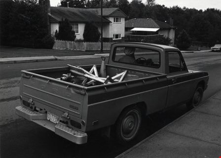
Engineering Department Truck
https://search.heritageburnaby.ca/link/archivedescription79440
- Repository
- City of Burnaby Archives
- Date
- October, 1976
- Collection/Fonds
- Burnaby Public Library Contemporary Visual Archive Project
- Description Level
- Item
- Physical Description
- 1 photograph : b&w ; 11 x 16 cm mounted on cardboard
- Scope and Content
- Photograph shows a District of Burnaby Engineering Department truck with the driver inside, parked on Cumberland Street near 17th Avenue.
- Repository
- City of Burnaby Archives
- Date
- October, 1976
- Collection/Fonds
- Burnaby Public Library Contemporary Visual Archive Project
- Physical Description
- 1 photograph : b&w ; 11 x 16 cm mounted on cardboard
- Description Level
- Item
- Record No.
- 556-292
- Access Restriction
- No restrictions
- Reproduction Restriction
- Reproduce for fair dealing purposes only
- Accession Number
- 2013-13
- Scope and Content
- Photograph shows a District of Burnaby Engineering Department truck with the driver inside, parked on Cumberland Street near 17th Avenue.
- Media Type
- Photograph
- Photographer
- Ross, Martha
- Notes
- Scope note taken directly from BPL photograph description.
- 1 b&w copy negative : 10 x 12.5 cm accompanying
- Geographic Access
- Cumberland Street
- 17th Avenue
- Historic Neighbourhood
- East Burnaby (Historic Neighbourhood)
- Planning Study Area
- Cariboo-Armstrong Area
Images
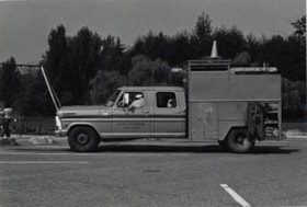
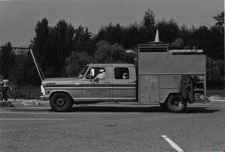
Engineering Department Truck
https://search.heritageburnaby.ca/link/archivedescription79441
- Repository
- City of Burnaby Archives
- Date
- September 16, 1976
- Collection/Fonds
- Burnaby Public Library Contemporary Visual Archive Project
- Description Level
- Item
- Physical Description
- 1 photograph : b&w ; 11 x 16 cm mounted on cardboard
- Scope and Content
- Photograph shows a District of Burnaby Engineering Department truck with the work crew inside, parked in Deer Lake Park at the east end of Deer Lake.
- Repository
- City of Burnaby Archives
- Date
- September 16, 1976
- Collection/Fonds
- Burnaby Public Library Contemporary Visual Archive Project
- Physical Description
- 1 photograph : b&w ; 11 x 16 cm mounted on cardboard
- Description Level
- Item
- Record No.
- 556-293
- Access Restriction
- No restrictions
- Reproduction Restriction
- Reproduce for fair dealing purposes only
- Accession Number
- 2013-13
- Scope and Content
- Photograph shows a District of Burnaby Engineering Department truck with the work crew inside, parked in Deer Lake Park at the east end of Deer Lake.
- Media Type
- Photograph
- Photographer
- Norton, Paul
- Notes
- Scope note taken directly from BPL photograph description.
- 1 b&w copy negative : 10 x 12.5 cm accompanying
- Geographic Access
- Cumberland Street
- 17th Avenue
- Historic Neighbourhood
- Burnaby Lake (Historic Neighbourhood)
- Planning Study Area
- Morley-Buckingham Area
Images
![Ernest and Frank Street, [between 1920 and 1925] thumbnail](/media/hpo/_Data/_Archives_Images/_Unrestricted/205/217-004.jpg?width=280)
Ernest and Frank Street
https://search.heritageburnaby.ca/link/archivedescription36072
- Repository
- City of Burnaby Archives
- Date
- [between 1920 and 1925]
- Collection/Fonds
- Burnaby Historical Society fonds
- Description Level
- Item
- Physical Description
- 1 photograph : col. ; 6 x 11 cm print
- Scope and Content
- Photograph of Ernest Street and his son Frank feeding the animals at the family farm on Cumberland Street.
- Repository
- City of Burnaby Archives
- Date
- [between 1920 and 1925]
- Collection/Fonds
- Burnaby Historical Society fonds
- Subseries
- Helen Street subseries
- Physical Description
- 1 photograph : col. ; 6 x 11 cm print
- Description Level
- Item
- Record No.
- 217-004
- Access Restriction
- No restrictions
- Reproduction Restriction
- No restrictions
- Accession Number
- BHS1989-6
- Scope and Content
- Photograph of Ernest Street and his son Frank feeding the animals at the family farm on Cumberland Street.
- Names
- Street, Ernest
- Street, Frank
- Media Type
- Photograph
- Notes
- Title based on contents of photograph
- 1 col. copy negative accompanying
- Geographic Access
- Cumberland Street
- Historic Neighbourhood
- East Burnaby (Historic Neighbourhood)
- Planning Study Area
- Cariboo-Armstrong Area
Images
![Ernest and Frank Street, [between 1920 and 1925] thumbnail](/media/hpo/_Data/_Archives_Images/_Unrestricted/205/217-004.jpg)
![Ernest Street family home, [192-?] thumbnail](/media/hpo/_Data/_Archives_Images/_Unrestricted/205/217-001.jpg?width=280)
Ernest Street family home
https://search.heritageburnaby.ca/link/archivedescription36069
- Repository
- City of Burnaby Archives
- Date
- [192-?]
- Collection/Fonds
- Burnaby Historical Society fonds
- Description Level
- Item
- Physical Description
- 1 photograph ; sepia ; 7.5 x 13.5 cm
- Scope and Content
- Photograph of a person sitting in front of the home identified as the Ernest Street family home at 1205 Cumberland Street (old street numbering).
- Repository
- City of Burnaby Archives
- Date
- [192-?]
- Collection/Fonds
- Burnaby Historical Society fonds
- Subseries
- Helen Street subseries
- Physical Description
- 1 photograph ; sepia ; 7.5 x 13.5 cm
- Description Level
- Item
- Record No.
- 217-001
- Access Restriction
- No restrictions
- Reproduction Restriction
- No known restrictions
- Accession Number
- BHS1989-6
- Scope and Content
- Photograph of a person sitting in front of the home identified as the Ernest Street family home at 1205 Cumberland Street (old street numbering).
- Subjects
- Buildings - Residential - Houses
- Media Type
- Photograph
- Notes
- Title based on contents of photograph
- Geographic Access
- Cumberland Street
- Historic Neighbourhood
- East Burnaby (Historic Neighbourhood)
- Planning Study Area
- Cariboo-Armstrong Area
Images
![Ernest Street family home, [192-?] thumbnail](/media/hpo/_Data/_Archives_Images/_Unrestricted/205/217-001.jpg)
![Ernest Street family home, [194-?] thumbnail](/media/hpo/_Data/_Archives_Images/_Unrestricted/205/217-002.jpg?width=280)
Ernest Street family home
https://search.heritageburnaby.ca/link/archivedescription36070
- Repository
- City of Burnaby Archives
- Date
- [194-?]
- Collection/Fonds
- Burnaby Historical Society fonds
- Description Level
- Item
- Physical Description
- 1 photograph : col. ; 5.5 x 12 cm print
- Scope and Content
- Photograph of the Ernest Street home after it was altered.
- Repository
- City of Burnaby Archives
- Date
- [194-?]
- Collection/Fonds
- Burnaby Historical Society fonds
- Subseries
- Helen Street subseries
- Physical Description
- 1 photograph : col. ; 5.5 x 12 cm print
- Description Level
- Item
- Record No.
- 217-002
- Access Restriction
- No restrictions
- Reproduction Restriction
- Reproduce for fair dealing purposes only
- Accession Number
- BHS1989-6
- Scope and Content
- Photograph of the Ernest Street home after it was altered.
- Subjects
- Buildings - Residential - Houses
- Media Type
- Photograph
- Notes
- Title based on contents of photograph
- 1 col. copy negative accompanying
- Geographic Access
- Cumberland Street
- Historic Neighbourhood
- East Burnaby (Historic Neighbourhood)
- Planning Study Area
- Cariboo-Armstrong Area
Images
![Ernest Street family home, [194-?] thumbnail](/media/hpo/_Data/_Archives_Images/_Unrestricted/205/217-002.jpg)
![Esther, Dot, Ben and man in front of Love farm house, [191-] thumbnail](/media/hpo/_Data/_BVM_Images/2022/2022_0032_0362_001.jpg?width=280)
Esther, Dot, Ben and man in front of Love farm house
https://search.heritageburnaby.ca/link/museumdescription19940
- Repository
- Burnaby Village Museum
- Date
- [191-]
- Collection/Fonds
- Esther Love Stanley fonds
- Description Level
- Item
- Physical Description
- 1 photograph : b&w ; 8 x 11 cm
- Scope and Content
- Photograph of Esther (Love) Stanley, Martha Dorothy "Dot" (Love) Brandrith, Benjamin Brandrith and unidentified man standing together outside in front of the Love farm house on Cumberland Road.
- Repository
- Burnaby Village Museum
- Collection/Fonds
- Esther Love Stanley fonds
- Description Level
- Item
- Physical Description
- 1 photograph : b&w ; 8 x 11 cm
- Scope and Content
- Photograph of Esther (Love) Stanley, Martha Dorothy "Dot" (Love) Brandrith, Benjamin Brandrith and unidentified man standing together outside in front of the Love farm house on Cumberland Road.
- Names
- Brandrith, Benjamin Jefferson "Ben"
- Brandrith, Martha Dorothy “Dot” Love
- Stanley, Esther Love
- Love Family
- Geographic Access
- Cumberland Street
- Street Address
- 7651 Cumberland Street
- Accession Code
- BV022.32.362
- Access Restriction
- No restrictions
- Reproduction Restriction
- No known restrictions
- Date
- [191-]
- Media Type
- Photograph
- Historic Neighbourhood
- East Burnaby (Historic Neighbourhood)
- Planning Study Area
- Cariboo-Armstrong Area
- Scan Resolution
- 600
- Scan Date
- 2023-06-09
- Notes
- Title based on contents of photograph
- Photograph is part of Esther Love Stanley photograph album 1 (BV022.32.1)
- Note in white ink on album page reads: "Esther, Dot, Ben, _"
Images
![Esther, Dot, Ben and man in front of Love farm house, [191-] thumbnail](/media/hpo/_Data/_BVM_Images/2022/2022_0032_0362_001.jpg)
![Esther Love Stanley with Mary and Ina, [192-] thumbnail](/media/hpo/_Data/_BVM_Images/2022/2022_0032_0180_001.jpg?width=280)
Esther Love Stanley with Mary and Ina
https://search.heritageburnaby.ca/link/museumdescription19758
- Repository
- Burnaby Village Museum
- Date
- [192-]
- Collection/Fonds
- Esther Love Stanley fonds
- Description Level
- Item
- Physical Description
- 1 photograph : b&w ; 7 x 11.5 cm
- Scope and Content
- Photograph of Esther (Love) Stanley holding her daughter Ina and crouched next to her daughter Mary on the lawn of the Love family farmhouse.
- Repository
- Burnaby Village Museum
- Collection/Fonds
- Esther Love Stanley fonds
- Description Level
- Item
- Physical Description
- 1 photograph : b&w ; 7 x 11.5 cm
- Scope and Content
- Photograph of Esther (Love) Stanley holding her daughter Ina and crouched next to her daughter Mary on the lawn of the Love family farmhouse.
- Subjects
- Persons - Children
- Geographic Access
- Cumberland Street
- Street Address
- 7651 Cumberland Street
- Accession Code
- BV022.32.180
- Access Restriction
- No restrictions
- Reproduction Restriction
- No known restrictions
- Date
- [192-]
- Media Type
- Photograph
- Historic Neighbourhood
- East Burnaby (Historic Neighbourhood)
- Planning Study Area
- Cariboo-Armstrong Area
- Scan Resolution
- 600
- Scan Date
- 2023-04-04
- Notes
- Title based on contents of photograph
- Photograph is part of Esther Love Stanley photograph album 1 (BV022.32.1)
- Note in white ink on album page reads: "Mary, Esther, Ina"
Images
![Esther Love Stanley with Mary and Ina, [192-] thumbnail](/media/hpo/_Data/_BVM_Images/2022/2022_0032_0180_001.jpg)
Exterior demolition, north facade
https://search.heritageburnaby.ca/link/museumdescription10883
- Repository
- Burnaby Village Museum
- Date
- April 11, 1988
- Collection/Fonds
- Burnaby Village Museum fonds
- Description Level
- Item
- Physical Description
- 1 photograph : b&w negative ; 35 mm
- Scope and Content
- Photograph of exterior demolition of north facade inside of the Love farmhouse while it was located at 7651 Cumberland Street (the corner of 14th Avenue and Cumberland Street). The photograph was taken of the house once it was saved and acquired by the Burnaby Village Museum.
- Repository
- Burnaby Village Museum
- Collection/Fonds
- Burnaby Village Museum fonds
- Series
- Jesse Love farmhouse series
- Description Level
- Item
- Physical Description
- 1 photograph : b&w negative ; 35 mm
- Material Details
- Photograph is part of Film roll "H" - 36 b&w photographs that are a part of a collection described as BV018.41.82
- Scope and Content
- Photograph of exterior demolition of north facade inside of the Love farmhouse while it was located at 7651 Cumberland Street (the corner of 14th Avenue and Cumberland Street). The photograph was taken of the house once it was saved and acquired by the Burnaby Village Museum.
- Subjects
- Buildings - Heritage
- Geographic Access
- Cumberland Street
- Street Address
- 7651 Cumberland Street
- Accession Code
- BV018.41.405
- Access Restriction
- No restrictions
- Reproduction Restriction
- No known restrictions
- Date
- April 11, 1988
- Media Type
- Photograph
- Historic Neighbourhood
- East Burnaby (Historic Neighbourhood)
- Planning Study Area
- Cariboo-Armstrong Area
- Related Material
- See BV018.41.82 for File Level Description
- Scan Resolution
- 2400
- Scan Date
- 6/3/2019
- Scale
- 100
- Photographer
- Wolf, Jim
- Notes
- Title based on contents of photograph
- Photograph is a part of file level description "Photographic documentation of changes and move" BV018.41.82
Images


Exterior of Love farmhouse
https://search.heritageburnaby.ca/link/museumdescription1129
- Repository
- Burnaby Village Museum
- Date
- 1971 (date of original), copied 1990
- Collection/Fonds
- Love family fonds
- Description Level
- Item
- Physical Description
- 1 photograph : col. ; 10 x 15 cm print
- Scope and Content
- Photograph of the northern exterior of the Love farmhouse while Elsie (nee Love) Hughes, her husband John and son Brent lived in the house. The one storey section housed the kitchen which was added in 1903 to the original house which was built in 1893. The house is located at 7651 Cumberland Stree…
- Repository
- Burnaby Village Museum
- Collection/Fonds
- Love family fonds
- Description Level
- Item
- Physical Description
- 1 photograph : col. ; 10 x 15 cm print
- Material Details
- Copy print was made from re-photographing an original colour slide
- Scope and Content
- Photograph of the northern exterior of the Love farmhouse while Elsie (nee Love) Hughes, her husband John and son Brent lived in the house. The one storey section housed the kitchen which was added in 1903 to the original house which was built in 1893. The house is located at 7651 Cumberland Street (Address pre 1960: 1390 Cumberland Road) and was moved from its original site to the Burnaby Village Museum in 1988 and designated a Municipal Heritage Landmark in 1992.
- Geographic Access
- Cumberland Street
- Street Address
- 7651 Cumberland Street
- Accession Code
- BV992.15.10
- Access Restriction
- Restricted access
- Reproduction Restriction
- May be restricted by third party rights
- Date
- 1971 (date of original), copied 1990
- Media Type
- Photograph
- Historic Neighbourhood
- East Burnaby (Historic Neighbourhood)
- Planning Study Area
- Cariboo-Armstrong Area
- Scan Resolution
- 600
- Scan Date
- 01-Jun-09
- Scale
- 100
- Photographer
- Parker, Albert "Bert"
- Notes
- Title based on contents of photograph
Images


Exterior of Love farmhouse
https://search.heritageburnaby.ca/link/museumdescription1130
- Repository
- Burnaby Village Museum
- Date
- 1971 (date of original), copied 1990
- Collection/Fonds
- Love family fonds
- Description Level
- Item
- Physical Description
- 1 photograph : col. ; 10 x 15 cm print
- Scope and Content
- Photograph of the exterior of the west side of the Love farnhouse while Elsie (nee Love) Hughes, her husband John and son Brent lived in the house.The one storey section housed the kitchen which was attached to the main house in 1903. The house was located at 7651 Cumberland Street (Address pre 196…
- Repository
- Burnaby Village Museum
- Collection/Fonds
- Love family fonds
- Description Level
- Item
- Physical Description
- 1 photograph : col. ; 10 x 15 cm print
- Material Details
- Copy print was made from re-photographing an original colour slide
- Scope and Content
- Photograph of the exterior of the west side of the Love farnhouse while Elsie (nee Love) Hughes, her husband John and son Brent lived in the house.The one storey section housed the kitchen which was attached to the main house in 1903. The house was located at 7651 Cumberland Street (Address pre 1960: 1390 Cumberland Road) and was moved from its original site to the Burnaby Village Museum in 1988 and designated a Municipal Heritage Landmark in 1992.
- Geographic Access
- Cumberland Street
- Street Address
- 7651 Cumberland Street
- Accession Code
- BV992.15.11
- Access Restriction
- Restricted access
- Reproduction Restriction
- May be restricted by third party rights
- Date
- 1971 (date of original), copied 1990
- Media Type
- Photograph
- Historic Neighbourhood
- East Burnaby (Historic Neighbourhood)
- Planning Study Area
- Cariboo-Armstrong Area
- Scan Resolution
- 600
- Scan Date
- 01-Jun-09
- Scale
- 100
- Photographer
- Parker, Albert "Bert"
- Notes
- Title based on contents of photograph
Images


Exterior of Love farmhouse
https://search.heritageburnaby.ca/link/museumdescription1131
- Repository
- Burnaby Village Museum
- Date
- 1971 (date of original), copied 1990
- Collection/Fonds
- Love family fonds
- Description Level
- Item
- Physical Description
- 1 photograph : col. ; 10 x 15 cm print
- Scope and Content
- Photograph of the exterior of the Love farmhouse taken from the corner of Fourteenth Avenue and Cumberland Street while Elsie (nee Love) Hughes, her husband John and son Brent lived in the house. The house was located at 7651 Cumberland Street (Address pre 1960: 1390 Cumberland Road) and was moved …
- Repository
- Burnaby Village Museum
- Collection/Fonds
- Love family fonds
- Description Level
- Item
- Physical Description
- 1 photograph : col. ; 10 x 15 cm print
- Material Details
- Copy print was made from re-photographing an original colour slide
- Scope and Content
- Photograph of the exterior of the Love farmhouse taken from the corner of Fourteenth Avenue and Cumberland Street while Elsie (nee Love) Hughes, her husband John and son Brent lived in the house. The house was located at 7651 Cumberland Street (Address pre 1960: 1390 Cumberland Road) and was moved from its original site to the Burnaby Village Museum in 1988 and designated a Municipal Heritage Landmark in 1992.
- Geographic Access
- Cumberland Street
- 14th Avenue
- Street Address
- 7651 Cumberland Street
- Accession Code
- BV992.15.12
- Access Restriction
- Restricted access
- Reproduction Restriction
- May be restricted by third party rights
- Date
- 1971 (date of original), copied 1990
- Media Type
- Photograph
- Historic Neighbourhood
- East Burnaby (Historic Neighbourhood)
- Planning Study Area
- Cariboo-Armstrong Area
- Scan Resolution
- 600
- Scan Date
- 01-Jun-09
- Scale
- 100
- Photographer
- Parker, Albert "Bert"
- Notes
- Title based on contents of photograph
Images

Exterior view of kitchen
https://search.heritageburnaby.ca/link/museumdescription10878
- Repository
- Burnaby Village Museum
- Date
- April 11, 1988
- Collection/Fonds
- Burnaby Village Museum fonds
- Description Level
- Item
- Physical Description
- 1 photograph : b&w negative ; 35 mm
- Scope and Content
- Photograph of the exterior demoliiton work of the kitchen section being removed from the Love farmhouse in preparation for the move from 7651 Cumberland Street (the corner of 14th Avenue and Cumberland Street) to the Burnaby Village Museum.
- Repository
- Burnaby Village Museum
- Collection/Fonds
- Burnaby Village Museum fonds
- Series
- Jesse Love farmhouse series
- Description Level
- Item
- Physical Description
- 1 photograph : b&w negative ; 35 mm
- Material Details
- Photograph is part of Film roll "H" - 36 b&w photographs that are a part of a collection described as BV018.41.82
- Scope and Content
- Photograph of the exterior demoliiton work of the kitchen section being removed from the Love farmhouse in preparation for the move from 7651 Cumberland Street (the corner of 14th Avenue and Cumberland Street) to the Burnaby Village Museum.
- Subjects
- Buildings - Heritage
- Geographic Access
- Cumberland Street
- Street Address
- 7651 Cumberland Street
- Accession Code
- BV018.41.400
- Access Restriction
- No restrictions
- Reproduction Restriction
- No known restrictions
- Date
- April 11, 1988
- Media Type
- Photograph
- Historic Neighbourhood
- East Burnaby (Historic Neighbourhood)
- Planning Study Area
- Cariboo-Armstrong Area
- Related Material
- See BV018.41.82 for File Level Description
- Scan Resolution
- 2400
- Scan Date
- 6/3/2019
- Scale
- 100
- Photographer
- Wolf, Jim
- Notes
- Title based on contents of photograph
- Photograph is a part of file level description "Photographic documentation of changes and move" BV018.41.82
Images

![Exterior view of Love farmhouse, [between 1966 and 1971] thumbnail](/media/hpo/_Data/_BVM_Images/2019/2019_0003_0001_001.jpg?width=280)
Exterior view of Love farmhouse
https://search.heritageburnaby.ca/link/museumdescription9915
- Repository
- Burnaby Village Museum
- Date
- [between 1966 and 1971]
- Collection/Fonds
- Love family fonds
- Description Level
- Item
- Physical Description
- 1 photograph : col. ; 10 x 15 cm print
- Scope and Content
- Photograph of the exterior of the Love farmhouse located at 7651 Cumberland Street (Address pre 1960: 1390 Cumberland Road) with trees and bushes in the front yard and the driveway to the right. This photograph was taken while Elsie Hughes (nee Love), her husband John Hughes and son Brent Hughes li…
- Repository
- Burnaby Village Museum
- Collection/Fonds
- Love family fonds
- Description Level
- Item
- Physical Description
- 1 photograph : col. ; 10 x 15 cm print
- Material Details
- Copy print was made from re-photographing an original colour slide
- Scope and Content
- Photograph of the exterior of the Love farmhouse located at 7651 Cumberland Street (Address pre 1960: 1390 Cumberland Road) with trees and bushes in the front yard and the driveway to the right. This photograph was taken while Elsie Hughes (nee Love), her husband John Hughes and son Brent Hughes lived in the house.
- History
- Elsie is the daughter of Sarah (nee Love) and William Parker. Sarah and William purchased the Love farmhouse in 1928, shortly after the death of Sarah's father, Jesse Love. Sarah and William Parker lived in the house with their three children, Albert, Bill and Elsie. William Parker died in 1961 and Sarah continued to live in the house until 1966 before selling it to her daughter Elsie and son in law John Hughes. Elsie and John lived in the house with their son Brent until 1971.
- Subjects
- Buildings - Heritage
- Geographic Access
- Cumberland Street
- Street Address
- 7651 Cumberland Street
- Accession Code
- BV019.3.1
- Access Restriction
- No restrictions
- Reproduction Restriction
- No known restrictions
- Date
- [between 1966 and 1971]
- Media Type
- Photograph
- Historic Neighbourhood
- East Burnaby (Historic Neighbourhood)
- Planning Study Area
- Cariboo-Armstrong Area
- Scan Resolution
- 300
- Scan Date
- 31-Jan-2019
- Scale
- 96
- Photographer
- Parker, Albert "Bert"
- Notes
- Title based on contents of photograph.
Images
![Exterior view of Love farmhouse, [between 1966 and 1971] thumbnail](/media/hpo/_Data/_BVM_Images/2019/2019_0003_0001_001.jpg)
![Exterior view of Love farmhouse, [between 1966 and 1970] thumbnail](/media/hpo/_Data/_BVM_Images/2019/2019_0003_0003_001.jpg?width=280)
Exterior view of Love farmhouse
https://search.heritageburnaby.ca/link/museumdescription9917
- Repository
- Burnaby Village Museum
- Date
- [between 1966 and 1970]
- Collection/Fonds
- Love family fonds
- Description Level
- Item
- Physical Description
- 1 photograph : col. ; 10 x 15 cm print
- Scope and Content
- Photograph of a side view of the exterior of the Love farmhouse located at 7651 Cumberland Street (Address pre 1960: 1390 Cumberland Road) with trees and bushes along the side of the house and a gravel driveway. In this side view of the house, you can see the kitchen addition and verandah. This pho…
- Repository
- Burnaby Village Museum
- Collection/Fonds
- Love family fonds
- Description Level
- Item
- Physical Description
- 1 photograph : col. ; 10 x 15 cm print
- Material Details
- Copy print was made from re-photographing an original colour slide
- Scope and Content
- Photograph of a side view of the exterior of the Love farmhouse located at 7651 Cumberland Street (Address pre 1960: 1390 Cumberland Road) with trees and bushes along the side of the house and a gravel driveway. In this side view of the house, you can see the kitchen addition and verandah. This photograph was taken while Elsie Hughes (nee Love), her husband John Hughes and son Brent Hughes lived in the house. Elsie is the daughter of Sarah (nee Love) and William Parker. Sarah and William purchased the house in 1928, shortly after the death of Sarah's father, Jesse Love. Sarah and William Parker lived in the house with their three children, Albert, Bill and Elsie. William Parker died in 1961 and Sarah continued to live in the house until 1966 before selling it to her daughter Elsie and son in law John Hughes. Elsie and John lived in the house with their son Brent until 1971.
- Subjects
- Buildings - Heritage
- Geographic Access
- Cumberland Street
- Street Address
- 7651 Cumberland Street
- Accession Code
- BV019.3.3
- Access Restriction
- No restrictions
- Reproduction Restriction
- No known restrictions
- Date
- [between 1966 and 1970]
- Media Type
- Photograph
- Historic Neighbourhood
- East Burnaby (Historic Neighbourhood)
- Planning Study Area
- Cariboo-Armstrong Area
- Scan Resolution
- 600
- Scan Date
- 31-Jan-2019
- Scale
- 96
- Photographer
- Parker, Albert "Bert"
- Notes
- Title based on contents of photograph
Images
![Exterior view of Love farmhouse, [between 1966 and 1970] thumbnail](/media/hpo/_Data/_BVM_Images/2019/2019_0003_0003_001.jpg)
![Exterior view of Love farmhouse, [between 1966 and 1970] thumbnail](/media/hpo/_Data/_BVM_Images/2019/2019_0003_0004_001.jpg?width=280)
Exterior view of Love farmhouse
https://search.heritageburnaby.ca/link/museumdescription9918
- Repository
- Burnaby Village Museum
- Date
- [between 1966 and 1970]
- Collection/Fonds
- Love family fonds
- Description Level
- Item
- Physical Description
- 1 photograph : col. ; 10 x 15 cm print
- Scope and Content
- Photograph of the south east side of the Love farmhouse located at 7651 Cumberland Street (Address pre 1960: 1390 Cumberland Road). Flowers grow on trellises against the verandah and a dog sits on the lawn alongside gardens, trees, wooden chairs and a picnic table. This photograph was taken while E…
- Repository
- Burnaby Village Museum
- Collection/Fonds
- Love family fonds
- Description Level
- Item
- Physical Description
- 1 photograph : col. ; 10 x 15 cm print
- Material Details
- Copy print was made from re-photographing an original colour slide
- Scope and Content
- Photograph of the south east side of the Love farmhouse located at 7651 Cumberland Street (Address pre 1960: 1390 Cumberland Road). Flowers grow on trellises against the verandah and a dog sits on the lawn alongside gardens, trees, wooden chairs and a picnic table. This photograph was taken while Elsie Hughes (nee Love), her husband John Hughes and son Brent Hughes lived in the house. Elsie is the daughter of Sarah (nee Love) and William Parker. Sarah and William purchased the house in 1928, shortly after the death of Sarah's father, Jesse Love. Sarah and William Parker lived in the house with their three children, Albert, Bill and Elsie. William Parker died in 1961 and Sarah continued to live in the house until 1966 before selling it to her daughter Elsie and son in law John Hughes. Elsie and John lived in the house with their son Brent until 1971.
- Subjects
- Buildings - Heritage
- Geographic Access
- Cumberland Street
- Street Address
- 7651 Cumberland Street
- Accession Code
- BV019.3.4
- Access Restriction
- No restrictions
- Reproduction Restriction
- No known restrictions
- Date
- [between 1966 and 1970]
- Media Type
- Photograph
- Historic Neighbourhood
- East Burnaby (Historic Neighbourhood)
- Planning Study Area
- Cariboo-Armstrong Area
- Scan Resolution
- 600
- Scan Date
- 31-Jan-2019
- Scale
- 96
- Photographer
- Parker, Albert "Bert"
- Notes
- Title based on contents of photograph
Images
![Exterior view of Love farmhouse, [between 1966 and 1970] thumbnail](/media/hpo/_Data/_BVM_Images/2019/2019_0003_0004_001.jpg)
![Exterior view of Love farmhouse, [between 1966 and 1970] thumbnail](/media/hpo/_Data/_BVM_Images/2019/2019_0003_0011_001.jpg?width=280)
Exterior view of Love farmhouse
https://search.heritageburnaby.ca/link/museumdescription9921
- Repository
- Burnaby Village Museum
- Date
- [between 1966 and 1970]
- Collection/Fonds
- Love family fonds
- Description Level
- Item
- Physical Description
- 1 photograph : col. ; 10 x 15 cm print
- Scope and Content
- Photograph of the south east side of the Love farmhouse located at 7651 Cumberland Street (Address pre 1960: 1390 Cumberland Road). Flowers are growing on trellises against the pillars of the verandah and there are two wooden lawn chairs and a picnic table on the lawn under a large tree. This photo…
- Repository
- Burnaby Village Museum
- Collection/Fonds
- Love family fonds
- Description Level
- Item
- Physical Description
- 1 photograph : col. ; 10 x 15 cm print
- Material Details
- Copy print was made from re-photographing an original colour slide
- Scope and Content
- Photograph of the south east side of the Love farmhouse located at 7651 Cumberland Street (Address pre 1960: 1390 Cumberland Road). Flowers are growing on trellises against the pillars of the verandah and there are two wooden lawn chairs and a picnic table on the lawn under a large tree. This photograph was taken while Elsie Hughes (nee Love), her husband John Hughes and son Brent Hughes lived in the house. Elsie is the daughter of Sarah (nee Love) and William Parker. Sarah and William purchased the house in 1928, shortly after the death of Sarah's father, Jesse Love. Sarah and William Parker lived in the house with their three children, Albert, Bill and Elsie. William Parker died in 1961 and Sarah continued to live in the house until 1966 before selling it to her daughter Elsie and son in law John Hughes. Elsie and John lived in the house with their son Brent until 1971.
- Subjects
- Buildings - Heritage
- Geographic Access
- Cumberland Street
- Street Address
- 7651 Cumberland Street
- Accession Code
- BV019.3.11
- Access Restriction
- No restrictions
- Reproduction Restriction
- No known restrictions
- Date
- [between 1966 and 1970]
- Media Type
- Photograph
- Historic Neighbourhood
- East Burnaby (Historic Neighbourhood)
- Planning Study Area
- Cariboo-Armstrong Area
- Scan Resolution
- 600
- Scan Date
- 31-Jan-2019
- Scale
- 96
- Photographer
- Parker, Albert "Bert"
- Notes
- Title based on contents of photograph
Images
![Exterior view of Love farmhouse, [between 1966 and 1970] thumbnail](/media/hpo/_Data/_BVM_Images/2019/2019_0003_0011_001.jpg)
![Four generations, [between 1900 and 1909] (date of original), copied [1988] thumbnail](/media/hpo/_Data/_BVM_Images/2018/2018_0041_0200_001.jpg?width=280)
Four generations
https://search.heritageburnaby.ca/link/museumdescription9959
- Repository
- Burnaby Village Museum
- Date
- [between 1900 and 1909] (date of original), copied [1988]
- Collection/Fonds
- Burnaby Village Museum fonds
- Description Level
- Item
- Physical Description
- 1 photograph : col. slide ; 35 mm
- Scope and Content
- Photograph of (left to right) Annn (Annie) Elizabeth Whiting (nee Love), her mother, Mrs. Martha Love and her grandfather George Leonard and her daughter Edith Whiting.The group is gathered together outside in a yard with a fence of what might be the home of Jesse and Martha Love.
- Repository
- Burnaby Village Museum
- Collection/Fonds
- Burnaby Village Museum fonds
- Series
- Jesse Love farmhouse series
- Subseries
- Love family photographs subseries
- Description Level
- Item
- Physical Description
- 1 photograph : col. slide ; 35 mm
- Scope and Content
- Photograph of (left to right) Annn (Annie) Elizabeth Whiting (nee Love), her mother, Mrs. Martha Love and her grandfather George Leonard and her daughter Edith Whiting.The group is gathered together outside in a yard with a fence of what might be the home of Jesse and Martha Love.
- Subjects
- Structures - Fences
- Names
- Leonard, George
- Love Family
- Whiting, Annie Elizabeth Love
- Clayton, Edith Annie Whiting
- Stanley, Esther Love
- Love, Martha Leonard, 1858-1920
- Geographic Access
- Cumberland Street
- Street Address
- 7651 Cumberland Street
- Accession Code
- BV018.41.200
- Access Restriction
- No restrictions
- Reproduction Restriction
- May be restricted by third party rights
- Date
- [between 1900 and 1909] (date of original), copied [1988]
- Media Type
- Photograph
- Historic Neighbourhood
- East Burnaby (Historic Neighbourhood)
- Planning Study Area
- Cariboo-Armstrong Area
- Scan Resolution
- 2400
- Scan Date
- 4-Mar-2019
- Scale
- 100
- Notes
- Title based on contents of photograph
Images
![Four generations, [between 1900 and 1909] (date of original), copied [1988] thumbnail](/media/hpo/_Data/_BVM_Images/2018/2018_0041_0200_001.jpg)
From George Derby Health Centre
https://search.heritageburnaby.ca/link/archivedescription37537
- Repository
- City of Burnaby Archives
- Date
- December 20, 1948 (date of original), copied 1991
- Collection/Fonds
- Burnaby Historical Society fonds
- Description Level
- Item
- Physical Description
- 1 photograph : b&w ; 2.9 x 5.0 cm print on contact sheet 20.2 x 25.3 cm
- Scope and Content
- Photograph taken from the George Derby Health Centre facing north. There is snow on the trees, no buildings are visible except for a small shack, and Burnaby Mountain can be seen in the background.
- Repository
- City of Burnaby Archives
- Date
- December 20, 1948 (date of original), copied 1991
- Collection/Fonds
- Burnaby Historical Society fonds
- Subseries
- Burnaby Image Bank subseries
- Physical Description
- 1 photograph : b&w ; 2.9 x 5.0 cm print on contact sheet 20.2 x 25.3 cm
- Description Level
- Item
- Record No.
- 370-125
- Access Restriction
- No restrictions
- Reproduction Restriction
- No known restrictions
- Accession Number
- BHS1999-03
- Scope and Content
- Photograph taken from the George Derby Health Centre facing north. There is snow on the trees, no buildings are visible except for a small shack, and Burnaby Mountain can be seen in the background.
- Subjects
- Geographic Features - Mountains
- Media Type
- Photograph
- Notes
- Title based on contents of photograph
- 1 b&w copy negative accompanying
- Geographic Access
- Cumberland Street
- Burnaby Mountain Conservation Area
- Street Address
- 7550 Cumberland Street
- Historic Neighbourhood
- East Burnaby (Historic Neighbourhood)
- Planning Study Area
- Cariboo-Armstrong Area
Images


Front hallway entrance of Love farmhouse
https://search.heritageburnaby.ca/link/museumdescription1122
- Repository
- Burnaby Village Museum
- Date
- 1971 (date of original), copied 1990
- Collection/Fonds
- Love family fonds
- Description Level
- Item
- Physical Description
- 1 photograph : col. ; 15 x 10 cm print
- Scope and Content
- Photograph of the front hallway and entrance door of the Love farmhouse while Elsie (nee Love) Hughes, her husband John and son Brent lived in the house. The house was located at 7651 Cumberland Street (Address pre 1960: 1390 Cumberland Road) and was moved from its original site to the Burnaby Vill…
- Repository
- Burnaby Village Museum
- Collection/Fonds
- Love family fonds
- Description Level
- Item
- Physical Description
- 1 photograph : col. ; 15 x 10 cm print
- Material Details
- Copy print was made from re-photographing an original colour slide
- Scope and Content
- Photograph of the front hallway and entrance door of the Love farmhouse while Elsie (nee Love) Hughes, her husband John and son Brent lived in the house. The house was located at 7651 Cumberland Street (Address pre 1960: 1390 Cumberland Road) and was moved from its original site to the Burnaby Village Museum in 1988 and designated a Municipal Heritage Landmark in 1992.
- Geographic Access
- Cumberland Street
- Street Address
- 7651 Cumberland Street
- Accession Code
- BV992.15.3
- Access Restriction
- Restricted access
- Reproduction Restriction
- May be restricted by third party rights
- Date
- 1971 (date of original), copied 1990
- Media Type
- Photograph
- Historic Neighbourhood
- East Burnaby (Historic Neighbourhood)
- Planning Study Area
- Cariboo-Armstrong Area
- Scan Resolution
- 600
- Scan Date
- 01-Jun-09
- Scale
- 100
- Photographer
- Parker, Albert "Bert"
- Notes
- Title based on contents of photograph
Images

![George Derby Health Centre, [between 1950 and 1954] (date of original), copied 1991 thumbnail](/media/hpo/_Data/_Archives_Images/_Unrestricted/370/370-121.jpg?width=280)
George Derby Health Centre
https://search.heritageburnaby.ca/link/archivedescription37533
- Repository
- City of Burnaby Archives
- Date
- [between 1950 and 1954] (date of original), copied 1991
- Collection/Fonds
- Burnaby Historical Society fonds
- Description Level
- Item
- Physical Description
- 1 photograph : b&w ; 2.5 x 4.1 cm print on contact sheet 20.2 x 25.3 cm
- Scope and Content
- Photograph of the George Derby Health Centre which includes the main building, parking lot and grounds.
- Repository
- City of Burnaby Archives
- Date
- [between 1950 and 1954] (date of original), copied 1991
- Collection/Fonds
- Burnaby Historical Society fonds
- Subseries
- Burnaby Image Bank subseries
- Physical Description
- 1 photograph : b&w ; 2.5 x 4.1 cm print on contact sheet 20.2 x 25.3 cm
- Description Level
- Item
- Record No.
- 370-121
- Access Restriction
- No restrictions
- Reproduction Restriction
- No restrictions
- Accession Number
- BHS1999-03
- Scope and Content
- Photograph of the George Derby Health Centre which includes the main building, parking lot and grounds.
- Subjects
- Geographic Features - Automobile Parking Lots
- Buildings - Civic - Hospitals
- Documentary Artifacts - Postcards
- Media Type
- Photograph
- Notes
- Title based on caption on photograph
- 1 b&w copy negative accompanying
- Print was copied from a postcard original
- Caption at bottom of photograph reads, "George Derby Health Centre / Burnaby B.C."
- Geographic Access
- Cumberland Street
- Street Address
- 7550 Cumberland Street
- Historic Neighbourhood
- East Burnaby (Historic Neighbourhood)
- Planning Study Area
- Cariboo-Armstrong Area
Images
![George Derby Health Centre, [between 1950 and 1954] (date of original), copied 1991 thumbnail](/media/hpo/_Data/_Archives_Images/_Unrestricted/370/370-121.jpg)
George Derby Health Centre
https://search.heritageburnaby.ca/link/archivedescription37538
- Repository
- City of Burnaby Archives
- Date
- December 20, 1948 (date of original), copied 1991
- Collection/Fonds
- Burnaby Historical Society fonds
- Description Level
- Item
- Physical Description
- 1 photograph : b&w ; 2.9 x 5.2 cm print on contact sheet 20.2 x 25.3 cm
- Scope and Content
- Photograph of the George Derby Health Centre main building and grounds in the snow.
- Repository
- City of Burnaby Archives
- Date
- December 20, 1948 (date of original), copied 1991
- Collection/Fonds
- Burnaby Historical Society fonds
- Subseries
- Burnaby Image Bank subseries
- Physical Description
- 1 photograph : b&w ; 2.9 x 5.2 cm print on contact sheet 20.2 x 25.3 cm
- Description Level
- Item
- Record No.
- 370-126
- Access Restriction
- No restrictions
- Reproduction Restriction
- No known restrictions
- Accession Number
- BHS1999-03
- Scope and Content
- Photograph of the George Derby Health Centre main building and grounds in the snow.
- Subjects
- Buildings - Civic - Hospitals
- Media Type
- Photograph
- Notes
- Title based on contents of photograph
- 1 b&w copy negative accompanying
- Geographic Access
- Cumberland Street
- Street Address
- 7550 Cumberland Street
- Historic Neighbourhood
- East Burnaby (Historic Neighbourhood)
- Planning Study Area
- Cariboo-Armstrong Area
Images

![George Derby Health Centre, [between 1950 and 1954] (date of original), copied 1991 thumbnail](/media/hpo/_Data/_Archives_Images/_Unrestricted/370/370-127.jpg?width=280)
George Derby Health Centre
https://search.heritageburnaby.ca/link/archivedescription37539
- Repository
- City of Burnaby Archives
- Date
- [between 1950 and 1954] (date of original), copied 1991
- Collection/Fonds
- Burnaby Historical Society fonds
- Description Level
- Item
- Physical Description
- 1 photograph : b&w ; 3.4 x 5.0 cm print on contact sheet 20.2 x 25.3 cm
- Scope and Content
- Aerial photograph of the George Derby Health Centre, copied from a postcard.
- Repository
- City of Burnaby Archives
- Date
- [between 1950 and 1954] (date of original), copied 1991
- Collection/Fonds
- Burnaby Historical Society fonds
- Subseries
- Burnaby Image Bank subseries
- Physical Description
- 1 photograph : b&w ; 3.4 x 5.0 cm print on contact sheet 20.2 x 25.3 cm
- Description Level
- Item
- Record No.
- 370-127
- Access Restriction
- No restrictions
- Reproduction Restriction
- No restrictions
- Accession Number
- BHS1999-03
- Scope and Content
- Aerial photograph of the George Derby Health Centre, copied from a postcard.
- Media Type
- Photograph
- Notes
- Title based on caption on photograph
- 1 b&w copy negative accompanying
- Caption on photograph reads, "George Derby Health Centre, Burnaby B.C."
- Geographic Access
- Cumberland Street
- Street Address
- 7550 Cumberland Street
- Historic Neighbourhood
- East Burnaby (Historic Neighbourhood)
- Planning Study Area
- Cariboo-Armstrong Area
Images
![George Derby Health Centre, [between 1950 and 1954] (date of original), copied 1991 thumbnail](/media/hpo/_Data/_Archives_Images/_Unrestricted/370/370-127.jpg)
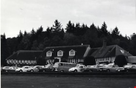
George Derby Hospital
https://search.heritageburnaby.ca/link/archivedescription79505
- Repository
- City of Burnaby Archives
- Date
- October, 1976
- Collection/Fonds
- Burnaby Public Library Contemporary Visual Archive Project
- Description Level
- Item
- Physical Description
- 1 photograph : b&w ; 11 x 16 cm mounted on cardboard
- Scope and Content
- Photograph of the administration building at George Derby Hospital. George Derby Health and Occupation Centre was constructed during the years 1946/1947. It was officially opened on April 10, 1947 at 7502 Cumberland Street (later 7550 Cumberland), on the corner of 17th Avenue. Its prime function wa…
- Repository
- City of Burnaby Archives
- Date
- October, 1976
- Collection/Fonds
- Burnaby Public Library Contemporary Visual Archive Project
- Physical Description
- 1 photograph : b&w ; 11 x 16 cm mounted on cardboard
- Description Level
- Item
- Record No.
- 556-332
- Access Restriction
- No restrictions
- Reproduction Restriction
- Reproduce for fair dealing purposes only
- Accession Number
- 2013-13
- Scope and Content
- Photograph of the administration building at George Derby Hospital. George Derby Health and Occupation Centre was constructed during the years 1946/1947. It was officially opened on April 10, 1947 at 7502 Cumberland Street (later 7550 Cumberland), on the corner of 17th Avenue. Its prime function was a rehabilitation centre for returning World War II veterans. In the fall of 1962 the Centre was amalgamated with Shaughnessy Hospital (Vancouver) and became the George Derby Wing.
- Subjects
- Buildings - Civic - Hospitals
- Media Type
- Photograph
- Photographer
- Salmon, Stu
- Notes
- Scope note taken directly from BPL photograph description
- 1 b&w copy negative : 10 x 12.5 cm accompanying
- Geographic Access
- Cumberland Street
- Street Address
- 7550 Cumberland Street
- Historic Neighbourhood
- East Burnaby (Historic Neighbourhood)
- Planning Study Area
- Cariboo-Armstrong Area
Images

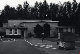
George Derby Hospital
https://search.heritageburnaby.ca/link/archivedescription79506
- Repository
- City of Burnaby Archives
- Date
- October, 1976
- Collection/Fonds
- Burnaby Public Library Contemporary Visual Archive Project
- Description Level
- Item
- Physical Description
- 1 photograph : b&w ; 11 x 16 cm mounted on cardboard
- Scope and Content
- Photograph shows the treatment building at the George Derby Hospital.
- Repository
- City of Burnaby Archives
- Date
- October, 1976
- Collection/Fonds
- Burnaby Public Library Contemporary Visual Archive Project
- Physical Description
- 1 photograph : b&w ; 11 x 16 cm mounted on cardboard
- Description Level
- Item
- Record No.
- 556-333
- Access Restriction
- No restrictions
- Reproduction Restriction
- Reproduce for fair dealing purposes only
- Accession Number
- 2013-13
- Scope and Content
- Photograph shows the treatment building at the George Derby Hospital.
- Subjects
- Buildings - Civic - Hospitals
- Media Type
- Photograph
- Photographer
- Salmon, Stu
- Notes
- Scope note taken directly from BPL photograph description.
- 1 b&w copy negative : 10 x 12.5 cm accompanying
- Geographic Access
- Cumberland Street
- Street Address
- 7550 Cumberland Street
- Historic Neighbourhood
- East Burnaby (Historic Neighbourhood)
- Planning Study Area
- Cariboo-Armstrong Area
Images
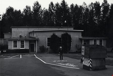
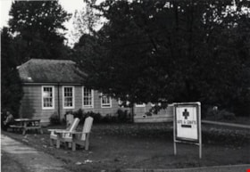
George Derby Hospital
https://search.heritageburnaby.ca/link/archivedescription79507
- Repository
- City of Burnaby Archives
- Date
- October, 1976
- Collection/Fonds
- Burnaby Public Library Contemporary Visual Archive Project
- Description Level
- Item
- Physical Description
- 1 photograph : b&w ; 11 x 16 cm mounted on cardboard
- Scope and Content
- Photograph shows the arts and crafts building at the George Derby Hospital.
- Repository
- City of Burnaby Archives
- Date
- October, 1976
- Collection/Fonds
- Burnaby Public Library Contemporary Visual Archive Project
- Physical Description
- 1 photograph : b&w ; 11 x 16 cm mounted on cardboard
- Description Level
- Item
- Record No.
- 556-334
- Access Restriction
- No restrictions
- Reproduction Restriction
- Reproduce for fair dealing purposes only
- Accession Number
- 2013-13
- Scope and Content
- Photograph shows the arts and crafts building at the George Derby Hospital.
- Subjects
- Buildings - Civic - Hospitals
- Media Type
- Photograph
- Photographer
- Salmon, Stu
- Notes
- Scope note taken directly from BPL photograph description.
- 1 b&w copy negative : 10 x 12.5 cm accompanying
- Geographic Access
- Cumberland Street
- Street Address
- 7550 Cumberland Street
- Historic Neighbourhood
- East Burnaby (Historic Neighbourhood)
- Planning Study Area
- Cariboo-Armstrong Area
Images