More like 'postcard'
Narrow Results By
Subject
- Adornment - Jewelry 1
- Advertising Medium 3
- Advertising Medium - Poster 1
- Advertising Medium - Signs and Signboards
- Aerial Photographs 132
- Agricultural Tools and Equipment - Plows 3
- Agriculture 3
- Agriculture - Crops 5
- Agriculture - Farms 55
- Agriculture - Fruit and Berries 11
- Agriculture - Poultry 4
- Animals 1
Person / Organization
- Admiral Hotel 1
- A. MacKenzie and Company Jubilee Store 3
- Astor Hotel 3
- Bennett, Eric Warrington Howard 1
- Bowker, A.D. 1
- British Columbia Auto Company 1
- Burnaby Chamber of Commerce 1
- Burnaby Christian Supply 1
- Burnaby General Hospital 1
- Burnaby Historical Society 1
- Burnaby Village Museum 5
- Cascade Drive-In Theatre 1

Burnaby Mountain Park and Centennial Pavilion
https://search.heritageburnaby.ca/link/archivedescription37408
- Repository
- City of Burnaby Archives
- Date
- 1970
- Collection/Fonds
- Burnaby Historical Society fonds
- Description Level
- Item
- Physical Description
- 1 photograph : col. postcard ; 9 x 14 cm
- Scope and Content
- Photographic postcard of the Burnaby Mountain Park sign a Centennial Pavilion. The caption on the back of the postcard reads: "The Centennial Pavilion was built in 1958 during British Columbia's Centenary. It is situated on Burnaby Mountain at an elevation of 1000 feet. Numerous footpaths througho…
- Repository
- City of Burnaby Archives
- Date
- 1970
- Collection/Fonds
- Burnaby Historical Society fonds
- Subseries
- Robert Prittie subseries
- Physical Description
- 1 photograph : col. postcard ; 9 x 14 cm
- Description Level
- Item
- Record No.
- 369-007
- Access Restriction
- No restrictions
- Reproduction Restriction
- Reproduce for fair dealing purposes only
- Accession Number
- BHS1999-01
- Scope and Content
- Photographic postcard of the Burnaby Mountain Park sign a Centennial Pavilion. The caption on the back of the postcard reads: "The Centennial Pavilion was built in 1958 during British Columbia's Centenary. It is situated on Burnaby Mountain at an elevation of 1000 feet. Numerous footpaths throughout the beautifully landscaped grounds lead to interesting view points which provide magnificent scenery of Burrard Inlet, Coast Range Mountains, City of Vancouver, and other surrounding Municipalities."
- Subjects
- Symbols - Flags
- Documentary Artifacts - Postcards
- Buildings - Recreational
- Advertising Medium - Signs and Signboards
- Media Type
- Photograph
- Photographer
- George Allen Aerial Photos Limited
- Notes
- Title based on caption
- Geographic Access
- Burnaby Mountain Conservation Area
- Centennial Way
- Street Address
- 100 Centennial Way
- Planning Study Area
- Burnaby Mountain Area
Images

![Woman standing outside a Grocery Store, [191-?] thumbnail](/media/hpo/_Data/_BVM_Images/1984/1984_0051_0054_001.jpg?width=280)
Woman standing outside a Grocery Store
https://search.heritageburnaby.ca/link/museumdescription270
- Repository
- Burnaby Village Museum
- Date
- [191-?]
- Collection/Fonds
- Burnaby Village Museum Photograph collection
- Description Level
- Item
- Physical Description
- 1 photograph : b&w postcard ; 9.1 x 13.9 cm
- Scope and Content
- Photographic postcard of an unidentified woman standing outside a grocery store. The store is a unit on the ground level of a brick building, behind which another building is visible. The display window includes stacks of canned goods, and advertisements for Rowntree's Cocoa, butter and margarine.…
- Repository
- Burnaby Village Museum
- Collection/Fonds
- Burnaby Village Museum Photograph collection
- Description Level
- Item
- Physical Description
- 1 photograph : b&w postcard ; 9.1 x 13.9 cm
- Scope and Content
- Photographic postcard of an unidentified woman standing outside a grocery store. The store is a unit on the ground level of a brick building, behind which another building is visible. The display window includes stacks of canned goods, and advertisements for Rowntree's Cocoa, butter and margarine. The sign on top of the display window was partially blocked by putting something over the area while printing the photograph. It reads, "Family Grocer [blocked letters] & Corn Dealer."
- Subjects
- Buildings - Commercial - Grocery Stores
- Advertising Medium - Signs and Signboards
- Documentary Artifacts - Postcards
- Accession Code
- HV984.51.54
- Access Restriction
- No restrictions
- Reproduction Restriction
- No known restrictions
- Date
- [191-?]
- Media Type
- Photograph
- Scan Resolution
- 600
- Scan Date
- 2023-10-31
- Notes
- Title based on contents of photograph
Images
![Woman standing outside a Grocery Store, [191-?] thumbnail](/media/hpo/_Data/_BVM_Images/1984/1984_0051_0054_001.jpg)
![Burnaby Chamber of Commerce, [1959] thumbnail](/media/Hpo/_Data/_Archives_Images/_Unrestricted/001/115-001.jpg?width=280)
Burnaby Chamber of Commerce
https://search.heritageburnaby.ca/link/archivedescription34711
- Repository
- City of Burnaby Archives
- Date
- [1959]
- Collection/Fonds
- Burnaby Historical Society fonds
- Description Level
- Item
- Physical Description
- 1 photograph : b&w ; 18.1 x 21.9 cm
- Scope and Content
- Photograph of the "Yesterday and Today" display, Burnaby Chamber of Commerce. Signs on either side of the display read, "Burnaby has ten miles of Fraser River frontage" and "Burnaby has ten miles of deepsea frontage." In the centre is a display of photographs. Signs on both sides of the display …
- Repository
- City of Burnaby Archives
- Date
- [1959]
- Collection/Fonds
- Burnaby Historical Society fonds
- Subseries
- Photographs subseries
- Physical Description
- 1 photograph : b&w ; 18.1 x 21.9 cm
- Description Level
- Item
- Record No.
- 115-001
- Access Restriction
- No restrictions
- Reproduction Restriction
- Reproduce for fair dealing purposes only
- Accession Number
- BHS2007-04
- Scope and Content
- Photograph of the "Yesterday and Today" display, Burnaby Chamber of Commerce. Signs on either side of the display read, "Burnaby has ten miles of Fraser River frontage" and "Burnaby has ten miles of deepsea frontage." In the centre is a display of photographs. Signs on both sides of the display read, "'Burnaby Yesterday and Today!' / Photo display by Burnaby Historical Society."
- Subjects
- Advertising Medium - Signs and Signboards
- Organizations
- Documentary Artifacts - Photographs
- Media Type
- Photograph
- Photographer
- Bower, Ralph
- Notes
- Title based on contents of photograph
- Stamped on back of photograph, "Photography by Ralph Bower"
Images
![Burnaby Chamber of Commerce, [1959] thumbnail](/media/Hpo/_Data/_Archives_Images/_Unrestricted/001/115-001.jpg)
![Map of Burnaby, [1971] thumbnail](/media/hpo/_Data/_BVM_Images/2005/2005_0054_0237_001.jpg?width=280)
Map of Burnaby
https://search.heritageburnaby.ca/link/museumdescription2189
- Repository
- Burnaby Village Museum
- Date
- [1971]
- Collection/Fonds
- Donald Copan collection
- Description Level
- Item
- Physical Description
- 1 photograph : b&w ; 8.9 x 12.7 cm
- Scope and Content
- Photograph of large sign with map of Burnaby. Map was used for Burnaby Centennial Celebrations display in 1971.
- Repository
- Burnaby Village Museum
- Collection/Fonds
- Donald Copan collection
- Series
- Copan album series
- Description Level
- Item
- Physical Description
- 1 photograph : b&w ; 8.9 x 12.7 cm
- Scope and Content
- Photograph of large sign with map of Burnaby. Map was used for Burnaby Centennial Celebrations display in 1971.
- Accession Code
- BV005.54.237
- Access Restriction
- No restrictions
- Reproduction Restriction
- May be restricted by third party rights
- Date
- [1971]
- Media Type
- Photograph
- Scan Resolution
- 600
- Scan Date
- July 21, 2020
- Scale
- 100
- Notes
- Title based on contents of photograph
Images
![Map of Burnaby, [1971] thumbnail](/media/hpo/_Data/_BVM_Images/2005/2005_0054_0237_001.jpg)

Model of Heritage Village
https://search.heritageburnaby.ca/link/museumdescription13818
- Repository
- Burnaby Village Museum
- Date
- Summer 1971
- Collection/Fonds
- Donald Copan collection
- Description Level
- Item
- Physical Description
- 1 photograph : col. ; 8.9 x 8.9 cm
- Scope and Content
- Photograph of model of Heritage Village with sign on display inside of Lougheed Mall (now Lougheed Town Centre).
- Repository
- Burnaby Village Museum
- Collection/Fonds
- Donald Copan collection
- Series
- Copan album series
- Description Level
- Item
- Physical Description
- 1 photograph : col. ; 8.9 x 8.9 cm
- Scope and Content
- Photograph of model of Heritage Village with sign on display inside of Lougheed Mall (now Lougheed Town Centre).
- Subjects
- Buildings - Commercial - Malls
- Buildings - Civic - Museums
- Advertising Medium - Signs and Signboards
- Accession Code
- BV005.54.619
- Access Restriction
- No restrictions
- Reproduction Restriction
- May be restricted by third party rights
- Date
- Summer 1971
- Media Type
- Photograph
- Scan Resolution
- 600
- Scan Date
- 18-Aug-2020
- Scale
- 100
- Notes
- Title based on contents of photograph
Images

![Sign for Heritage Village in Century Park, [August 1971] thumbnail](/media/hpo/_Data/_BVM_Images/2005/2005_0054_0617_001.jpg?width=280)
Sign for Heritage Village in Century Park
https://search.heritageburnaby.ca/link/museumdescription13816
- Repository
- Burnaby Village Museum
- Date
- [August 1971]
- Collection/Fonds
- Donald Copan collection
- Description Level
- Item
- Physical Description
- 1 photograph : b&w ; 8.9 x 12.7 cm
- Scope and Content
- Photograph of sign "Heritage Village in Century Park Commemorates '71 in Burnaby". Sign was on display with model of Heritage Village inside of Lougheed Mall (now Lougheed Town Centre).
- Repository
- Burnaby Village Museum
- Collection/Fonds
- Donald Copan collection
- Series
- Copan album series
- Description Level
- Item
- Physical Description
- 1 photograph : b&w ; 8.9 x 12.7 cm
- Scope and Content
- Photograph of sign "Heritage Village in Century Park Commemorates '71 in Burnaby". Sign was on display with model of Heritage Village inside of Lougheed Mall (now Lougheed Town Centre).
- Subjects
- Buildings - Commercial - Malls
- Buildings - Civic - Museums
- Advertising Medium - Signs and Signboards
- Accession Code
- BV005.54.617
- Access Restriction
- No restrictions
- Reproduction Restriction
- May be restricted by third party rights
- Date
- [August 1971]
- Media Type
- Photograph
- Scan Resolution
- 600
- Scan Date
- 18-Aug-2020
- Scale
- 100
- Notes
- Title based on contents of photograph
Images
![Sign for Heritage Village in Century Park, [August 1971] thumbnail](/media/hpo/_Data/_BVM_Images/2005/2005_0054_0617_001.jpg)
![Burnaby General Hospital, [1977] thumbnail](/media/hpo/_Data/_Archives_Images/_Unrestricted/480/480-227.jpg?width=280)
Burnaby General Hospital
https://search.heritageburnaby.ca/link/archivedescription45332
- Repository
- City of Burnaby Archives
- Date
- [1977]
- Collection/Fonds
- Columbian Newspaper collection
- Description Level
- Item
- Physical Description
- 1 photograph : b&w ; 15.5 x 24.5 cm
- Scope and Content
- Photograph of a large directional sign for the Burnaby General Hospital, with an ambulance parked in the background, just in front of the hospital.
- Repository
- City of Burnaby Archives
- Date
- [1977]
- Collection/Fonds
- Columbian Newspaper collection
- Physical Description
- 1 photograph : b&w ; 15.5 x 24.5 cm
- Description Level
- Item
- Record No.
- 480-227
- Access Restriction
- No restrictions
- Reproduction Restriction
- Reproduce for fair dealing purposes only
- Accession Number
- 2003-02
- Scope and Content
- Photograph of a large directional sign for the Burnaby General Hospital, with an ambulance parked in the background, just in front of the hospital.
- Subjects
- Buildings - Civic - Hospitals
- Advertising Medium - Signs and Signboards
- Transportation - Ambulances
- Names
- Burnaby General Hospital
- Media Type
- Photograph
- Notes
- Title based on contents of photograph
- Geographic Access
- Kincaid Street
- Street Address
- 3935 Kincaid Street
- Historic Neighbourhood
- Broadview (Historic Neighbourhood)
- Planning Study Area
- Cascade-Schou Area
Images
![Burnaby General Hospital, [1977] thumbnail](/media/hpo/_Data/_Archives_Images/_Unrestricted/480/480-227.jpg)

Burnaby hospital closes main entrance
https://search.heritageburnaby.ca/link/archivedescription95094
- Repository
- City of Burnaby Archives
- Date
- April 6, 2020
- Collection/Fonds
- Burnaby Photographic Society fonds
- Description Level
- Item
- Physical Description
- 1 photograph (tiff)
- Scope and Content
- Photograph of a rerouting sign posted to a sandwich board outside the Burnaby Hospital emergency lot. The sign states that the hospital entrance is closed and requests visitors use the Main Entrance of the hospital.
- Repository
- City of Burnaby Archives
- Date
- April 6, 2020
- Collection/Fonds
- Burnaby Photographic Society fonds
- Physical Description
- 1 photograph (tiff)
- Description Level
- Item
- Record No.
- 623-013
- Access Restriction
- No restrictions
- Reproduction Restriction
- No restrictions
- Accession Number
- 2020-10
- Scope and Content
- Photograph of a rerouting sign posted to a sandwich board outside the Burnaby Hospital emergency lot. The sign states that the hospital entrance is closed and requests visitors use the Main Entrance of the hospital.
- Subjects
- Buildings - Civic - Hospitals
- Geographic Features - Automobile Parking Lots
- Advertising Medium - Signs and Signboards
- Media Type
- Photograph
- Photographer
- Damer, Eric
- Notes
- Transcribed title
- Geographic Access
- Kincaid Street
- Street Address
- 3935 Kincaid Street
- Historic Neighbourhood
- Broadview (Historic Neighbourhood)
- Planning Study Area
- Cascade-Schou Area
Images

Musem interpreter welcomes visitors
https://search.heritageburnaby.ca/link/museumdescription14732
- Repository
- Burnaby Village Museum
- Date
- 14 July 2020
- Collection/Fonds
- Burnaby Village Museum COVID-19 collection
- Description Level
- Item
- Physical Description
- 1 photograph (jpg) : col. ; 350 dpi.
- Scope and Content
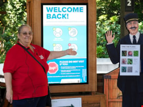
- Photograph of Burnaby Village Museum interpreter, Maria Peradenic greeting visitors in the Orientation Plaza at Burnaby Village Museum. Maria is standing next to a back lit "Welcome Back" sign providing guidelines and precautions to take while visiting.
- Repository
- Burnaby Village Museum
- Collection/Fonds
- Burnaby Village Museum COVID-19 collection
- Description Level
- Item
- Physical Description
- 1 photograph (jpg) : col. ; 350 dpi.
- Scope and Content
- Photograph of Burnaby Village Museum interpreter, Maria Peradenic greeting visitors in the Orientation Plaza at Burnaby Village Museum. Maria is standing next to a back lit "Welcome Back" sign providing guidelines and precautions to take while visiting.
- History
- Photograph was taken during the week of July 15th when Burnaby Village Museum was able to re-open to the public. The Museum was closed for most of it's seasonal schedule in 2020 due to the COVID-19 pandemic and public health orders. The Museum was able to re-open with restrictions for a shorter period.
- Accession Code
- BV020.19.4
- Access Restriction
- No restrictions
- Reproduction Restriction
- No known restrictions
- Date
- 14 July 2020
- Media Type
- Photograph
- Photographer
- Damer, Eric
- Notes
- Title based on contents of photograph
Images

![Second Street School banners, [1999] thumbnail](/media/hpo/_Data/_Archives_Images/_Unrestricted/535/535-3247.jpg?width=280)
Second Street School banners
https://search.heritageburnaby.ca/link/archivedescription98169
- Repository
- City of Burnaby Archives
- Date
- [1999]
- Collection/Fonds
- Burnaby NewsLeader photograph collection
- Description Level
- Item
- Physical Description
- 1 photograph (tiff) : col.
- Scope and Content
- Photograph of an Brian Sarginson, of the City of Burnaby Engineering Department, installing banners depicting birds and a growing garden on a streetlight by Second Street School. The banners were painted by students and local artist Joanne Folks.
- Repository
- City of Burnaby Archives
- Date
- [1999]
- Collection/Fonds
- Burnaby NewsLeader photograph collection
- Physical Description
- 1 photograph (tiff) : col.
- Description Level
- Item
- Record No.
- 535-3247
- Access Restriction
- No restrictions
- Reproduction Restriction
- No restrictions
- Accession Number
- 2018-12
- Scope and Content
- Photograph of an Brian Sarginson, of the City of Burnaby Engineering Department, installing banners depicting birds and a growing garden on a streetlight by Second Street School. The banners were painted by students and local artist Joanne Folks.
- Names
- Second Street School
- Media Type
- Photograph
- Photographer
- Bartel, Mario
- Notes
- Title based on caption
- Collected by editorial for use in a July 1999 issue of the Burnaby NewsLeader
- Caption from metadata: "Brian Sarginson, of Burnaby's Engineering Department, hangs some of the eight banners designed and painted by students at Second Ave. Community School, with a little guidance from local artist, Joanne Folks."
- Geographic Access
- 2nd Street
- Street Address
- 7502 2nd Street
- Historic Neighbourhood
- East Burnaby (Historic Neighbourhood)
- Planning Study Area
- Second Street Area
Images
![Second Street School banners, [1999] thumbnail](/media/hpo/_Data/_Archives_Images/_Unrestricted/535/535-3247.jpg)
Sign for Heritage Village official opening
https://search.heritageburnaby.ca/link/museumdescription13633
- Repository
- Burnaby Village Museum
- Date
- November 1971
- Collection/Fonds
- Donald Copan collection
- Description Level
- Item
- Physical Description
- 1 photograph : b&w ; 8.9 x 12.7 cm
- Scope and Content
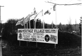
- Photograph of sign for the "Heritage Village Official Opening Friday November 19th 11am". The sign is located on Canada Way and Deer Lake Avenue. Flags flying over the sign include; BC Centennial; British Columbia and Canada flags.
- Repository
- Burnaby Village Museum
- Collection/Fonds
- Donald Copan collection
- Series
- Copan album series
- Description Level
- Item
- Physical Description
- 1 photograph : b&w ; 8.9 x 12.7 cm
- Scope and Content
- Photograph of sign for the "Heritage Village Official Opening Friday November 19th 11am". The sign is located on Canada Way and Deer Lake Avenue. Flags flying over the sign include; BC Centennial; British Columbia and Canada flags.
- Subjects
- Events - Openings
- Advertising Medium - Signs and Signboards
- Symbols - Flags
- Ceremonial Artifacts - Flags
- Names
- Burnaby Village Museum
- Accession Code
- BV005.54.528
- Access Restriction
- No restrictions
- Reproduction Restriction
- May be restricted by third party rights
- Date
- November 1971
- Media Type
- Photograph
- Scan Resolution
- 600
- Scan Date
- August 11, 2020
- Scale
- 100
- Notes
- Title based on contents of photograph
Images

Sign for Heritage Village official opening
https://search.heritageburnaby.ca/link/museumdescription13637
- Repository
- Burnaby Village Museum
- Date
- November 1971
- Collection/Fonds
- Donald Copan collection
- Description Level
- Item
- Physical Description
- 1 photograph : col. ; 8.9 x 8.9 cm
- Scope and Content
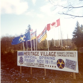
- Photograph of sign for the "Heritage Village Official Opening Friday November 19th 11am". The sign is located on Canada Way and Deer Lake Avenue. Flags flying over the sign include; BC Centennial; British Columbia and Canada flags.
- Repository
- Burnaby Village Museum
- Collection/Fonds
- Donald Copan collection
- Series
- Copan album series
- Description Level
- Item
- Physical Description
- 1 photograph : col. ; 8.9 x 8.9 cm
- Scope and Content
- Photograph of sign for the "Heritage Village Official Opening Friday November 19th 11am". The sign is located on Canada Way and Deer Lake Avenue. Flags flying over the sign include; BC Centennial; British Columbia and Canada flags.
- Subjects
- Events - Openings
- Advertising Medium - Signs and Signboards
- Symbols - Flags
- Ceremonial Artifacts - Flags
- Names
- Burnaby Village Museum
- Accession Code
- BV005.54.532
- Access Restriction
- No restrictions
- Reproduction Restriction
- May be restricted by third party rights
- Date
- November 1971
- Media Type
- Photograph
- Scan Resolution
- 600
- Scan Date
- August 11, 2020
- Scale
- 100
- Notes
- Title based on contents of photograph
Images


Crossing Royal Oak & Rumble Street
https://search.heritageburnaby.ca/link/archivedescription93686
- Repository
- City of Burnaby Archives
- Date
- May 19, 1978
- Collection/Fonds
- Burnaby Public Library Contemporary Visual Archive Project
- Description Level
- Item
- Physical Description
- 1 photograph : b&w ; 12.5 x 17.5 cm
- Scope and Content
- Photograph of the intersection of Royal Oak Avenue and Rumble Street. Cars and pedestrians are crossing the intersection, and the signs for businesses TD Bank, Standard Oil/Chevron gas station, Gulf gas station, and Baxter's Market are visible. The photograph is taken from a corner of the intersect…
- Repository
- City of Burnaby Archives
- Date
- May 19, 1978
- Collection/Fonds
- Burnaby Public Library Contemporary Visual Archive Project
- Physical Description
- 1 photograph : b&w ; 12.5 x 17.5 cm
- Description Level
- Item
- Record No.
- 556-643
- Access Restriction
- No restrictions
- Reproduction Restriction
- Reproduce for fair dealing purposes only
- Accession Number
- 2017-57
- Scope and Content
- Photograph of the intersection of Royal Oak Avenue and Rumble Street. Cars and pedestrians are crossing the intersection, and the signs for businesses TD Bank, Standard Oil/Chevron gas station, Gulf gas station, and Baxter's Market are visible. The photograph is taken from a corner of the intersection, facing southeast.
- Subjects
- Geographic Features - Roads
- Advertising Medium - Signs and Signboards
- Buildings - Commercial - Service Stations
- Transportation - Automobiles
- Buildings - Commercial
- Media Type
- Photograph
- Photographer
- van Mannen, Mark
- Notes
- Title taken from project information form
- Accompanied by a project information form and 1 photograph (b&w negative ; 9.5 x 12.5 cm)
- BPL no. 91
- Geographic Access
- Royal Oak Avenue
- Rumble Street
- Historic Neighbourhood
- Alta Vista (Historic Neighbourhood)
- Planning Study Area
- Sussex-Nelson Area
Images


Crossing Royal Oak & Rumble Street
https://search.heritageburnaby.ca/link/archivedescription93687
- Repository
- City of Burnaby Archives
- Date
- May 19, 1978
- Collection/Fonds
- Burnaby Public Library Contemporary Visual Archive Project
- Description Level
- Item
- Physical Description
- 1 photograph : b&w ; 12.5 x 17.5 cm
- Scope and Content
- Photograph of the intersection of Royal Oak Avenue and Rumble Street. Cars and pedestrians are crossing the intersection, and the signs for businesses Grace United Pharmacy, Standard Oil/Chevron gas station, Gulf gas station, and Royal Meats are visible. The photograph is taken from the Gulf gas st…
- Repository
- City of Burnaby Archives
- Date
- May 19, 1978
- Collection/Fonds
- Burnaby Public Library Contemporary Visual Archive Project
- Physical Description
- 1 photograph : b&w ; 12.5 x 17.5 cm
- Description Level
- Item
- Record No.
- 556-644
- Access Restriction
- No restrictions
- Reproduction Restriction
- Reproduce for fair dealing purposes only
- Accession Number
- 2017-57
- Scope and Content
- Photograph of the intersection of Royal Oak Avenue and Rumble Street. Cars and pedestrians are crossing the intersection, and the signs for businesses Grace United Pharmacy, Standard Oil/Chevron gas station, Gulf gas station, and Royal Meats are visible. The photograph is taken from the Gulf gas station parking lot, facing northwest.
- Subjects
- Advertising Medium - Signs and Signboards
- Geographic Features - Roads
- Transportation - Automobiles
- Buildings - Commercial
- Buildings - Commercial - Service Stations
- Media Type
- Photograph
- Photographer
- van Mannen, Mark
- Notes
- Title taken from project information form
- Accompanied by a project information form and 1 photograph (b&w negative ; 9.5 x 12.5 cm)
- BPL no. 92
- Geographic Access
- Royal Oak Avenue
- Rumble Street
- Historic Neighbourhood
- Alta Vista (Historic Neighbourhood)
- Planning Study Area
- Sussex-Nelson Area
Images

![Hotel Burnaby, [1958] thumbnail](/media/hpo/_Data/_Archives_Images/_Unrestricted/001/105-001.jpg?width=280)
Hotel Burnaby
https://search.heritageburnaby.ca/link/archivedescription34700
- Repository
- City of Burnaby Archives
- Date
- [1958]
- Collection/Fonds
- Burnaby Historical Society fonds
- Description Level
- Item
- Physical Description
- 1 photograph : b&w ; 20.3 x 25.2 cm
- Scope and Content
- Photograph of Hotel Burnaby at 1385 Kingsway (later renumbered 7610 Kingsway). An electric "Hotel Burnaby / Vacancy / Parking" sign can be seen on the right. A diner can be seen on the left side of the building with signs reading, "Dining Room," "Diner," "Soda Fountain," "Breakfasts, Lunches, Din…
- Repository
- City of Burnaby Archives
- Date
- [1958]
- Collection/Fonds
- Burnaby Historical Society fonds
- Subseries
- Photographs subseries
- Physical Description
- 1 photograph : b&w ; 20.3 x 25.2 cm
- Description Level
- Item
- Record No.
- 105-001
- Access Restriction
- No restrictions
- Reproduction Restriction
- Reproduce for fair dealing purposes only
- Accession Number
- BHS2007-04
- Scope and Content
- Photograph of Hotel Burnaby at 1385 Kingsway (later renumbered 7610 Kingsway). An electric "Hotel Burnaby / Vacancy / Parking" sign can be seen on the right. A diner can be seen on the left side of the building with signs reading, "Dining Room," "Diner," "Soda Fountain," "Breakfasts, Lunches, Dinners," "Coffee Bar," and "Licensed Premises." Coca-Cola advertisements are also visible. There are entrances to the building with signs above them readings, "Lobby," "Men," and "Ladies and Escorts."
- Subjects
- Advertising Medium - Signs and Signboards
- Buildings - Commercial - Hotels and Motels
- Buildings - Commercial - Restaurants
- Names
- Hotel Burnaby Limited
- Media Type
- Photograph
- Photographer
- Croton Studio Limited
- Notes
- Title based on contents of photograph
- Stamp on back of photograph reads, "Croton Studio / New Westminster BC"
- Geographic Access
- Kingsway
- Street Address
- 7610 Kingsway
- Historic Neighbourhood
- Edmonds (Historic Neighbourhood)
- Planning Study Area
- Edmonds Area
Images
![Hotel Burnaby, [1958] thumbnail](/media/hpo/_Data/_Archives_Images/_Unrestricted/001/105-001.jpg)

Kask's Filling Station
https://search.heritageburnaby.ca/link/archivedescription35533
- Repository
- City of Burnaby Archives
- Date
- 1930 (date of original), copied 1986
- Collection/Fonds
- Burnaby Historical Society fonds
- Description Level
- Item
- Physical Description
- 1 photograph : b&w ; 12.7 x 17.8 cm print
- Scope and Content
- Photograph of Kask's Filling Station, Kask's Camp, Barnet Road. It was located next to Kask's General Store to serve residents of the 30 to 35 rental cabins, plus the Kask home. The Kasks also operated a steam bath.
- Repository
- City of Burnaby Archives
- Date
- 1930 (date of original), copied 1986
- Collection/Fonds
- Burnaby Historical Society fonds
- Subseries
- Pioneer Tales subseries
- Physical Description
- 1 photograph : b&w ; 12.7 x 17.8 cm print
- Description Level
- Item
- Record No.
- 204-391
- Access Restriction
- No restrictions
- Reproduction Restriction
- No known restrictions
- Accession Number
- BHS1988-03
- Scope and Content
- Photograph of Kask's Filling Station, Kask's Camp, Barnet Road. It was located next to Kask's General Store to serve residents of the 30 to 35 rental cabins, plus the Kask home. The Kasks also operated a steam bath.
- Subjects
- Buildings - Commercial - General Stores
- Advertising Medium - Signs and Signboards
- Buildings - Commercial - Service Stations
- Media Type
- Photograph
- Notes
- Title based on contents of photograph
- Geographic Access
- Barnet Road
- Street Address
- 7501 Barnet Road
- Historic Neighbourhood
- Barnet (Historic Neighbourhood)
- Planning Study Area
- Burnaby Mountain Area
Images


Martello Group sign at 6615 Telford Avenue
https://search.heritageburnaby.ca/link/archivedescription98675
- Repository
- City of Burnaby Archives
- Date
- 2022
- Collection/Fonds
- Disappearing Burnaby collection
- Description Level
- Item
- Physical Description
- 1 photograph (jpeg) : col.
- Scope and Content
- Photograph of a sign, which reads "Professionally Managed by Martello," on the lawn of an apartment building located at 6615 Telford Avenue. The building was constructed in 1964. Other residential towers, a construction crane, and cars parked along Telford Avenue are visible in the background.
- Repository
- City of Burnaby Archives
- Date
- 2022
- Collection/Fonds
- Disappearing Burnaby collection
- Physical Description
- 1 photograph (jpeg) : col.
- Description Level
- Item
- Record No.
- 634-022
- Access Restriction
- No restrictions
- Reproduction Restriction
- No restrictions
- Accession Number
- 2022-14
- Scope and Content
- Photograph of a sign, which reads "Professionally Managed by Martello," on the lawn of an apartment building located at 6615 Telford Avenue. The building was constructed in 1964. Other residential towers, a construction crane, and cars parked along Telford Avenue are visible in the background.
- Subjects
- Buildings - Residential
- Buildings - Residential - Apartments
- Advertising Medium - Signs and Signboards
- Media Type
- Photograph
- Photographer
- Cheung, Nakita
- Notes
- Title taken from the associated blog post
- Associated blog post: https://disappearingburnaby.wordpress.com/2022/06/09/martello-group/
- Geographic Access
- Telford Avenue
- Street Address
- 6615 Telford Avenue
- Historic Neighbourhood
- Central Park (Historic Neighbourhood)
- Planning Study Area
- Maywood Area
Images


Mid-City Meats, Burnaby Christian Supply and Tommy's Produce
https://search.heritageburnaby.ca/link/archivedescription79226
- Repository
- City of Burnaby Archives
- Date
- September 15, 1976
- Collection/Fonds
- Burnaby Public Library Contemporary Visual Archive Project
- Description Level
- Item
- Physical Description
- 1 photograph : b&w ; 11 x 16 cm mounted on cardboard
- Scope and Content
- Photograph shows large billboards above Mid-City Meats, Burnaby Christian Supply and Tommy's Produce, located on Kingsway near Cassie Avenue. Burnaby Christian Supply was a music store prior to 1963 and Mid-City Meats was a drug store in the 1920s.
- Repository
- City of Burnaby Archives
- Date
- September 15, 1976
- Collection/Fonds
- Burnaby Public Library Contemporary Visual Archive Project
- Physical Description
- 1 photograph : b&w ; 11 x 16 cm mounted on cardboard
- Description Level
- Item
- Record No.
- 556-209
- Access Restriction
- No restrictions
- Reproduction Restriction
- Reproduce for fair dealing purposes only
- Accession Number
- 2013-13
- Scope and Content
- Photograph shows large billboards above Mid-City Meats, Burnaby Christian Supply and Tommy's Produce, located on Kingsway near Cassie Avenue. Burnaby Christian Supply was a music store prior to 1963 and Mid-City Meats was a drug store in the 1920s.
- Subjects
- Advertising Medium - Signs and Signboards
- Buildings - Commercial - Butcher Shops
- Buildings - Commercial - Grocery Stores
- Media Type
- Photograph
- Photographer
- McCarron, John
- Notes
- Scope note taken directly from BPL photograph description.
- 1 b&w copy negative : 10 x 12.5 cm accompanying
- Geographic Access
- Kingsway
- Cassie Avenue
- Historic Neighbourhood
- Central Park (Historic Neighbourhood)
- Planning Study Area
- Maywood Area
Images


Old Orchard Shopping Centre
https://search.heritageburnaby.ca/link/archivedescription93603
- Repository
- City of Burnaby Archives
- Date
- October 9, 1977
- Collection/Fonds
- Burnaby Public Library Contemporary Visual Archive Project
- Description Level
- Item
- Physical Description
- 1 photograph : b&w ; 12.5 x 17.5 cm
- Scope and Content
- Photograph of the Old Orchard Shopping Centre, located at Kingsway and Willingdon. The photograph is taken from across the road, facing northwest, and focuses on the shopping centre sign. The other stores' signs, including Shoppers Drug Mart and Autoplan, and a high-rise apartment building are visi…
- Repository
- City of Burnaby Archives
- Date
- October 9, 1977
- Collection/Fonds
- Burnaby Public Library Contemporary Visual Archive Project
- Physical Description
- 1 photograph : b&w ; 12.5 x 17.5 cm
- Description Level
- Item
- Record No.
- 556-560
- Access Restriction
- No restrictions
- Reproduction Restriction
- Reproduce for fair dealing purposes only
- Accession Number
- 2017-57
- Scope and Content
- Photograph of the Old Orchard Shopping Centre, located at Kingsway and Willingdon. The photograph is taken from across the road, facing northwest, and focuses on the shopping centre sign. The other stores' signs, including Shoppers Drug Mart and Autoplan, and a high-rise apartment building are visible in the background.
- Subjects
- Buildings - Commercial - Malls
- Advertising Medium - Signs and Signboards
- Buildings - Residential - Apartments
- Media Type
- Photograph
- Photographer
- Chapman, Fred
- Notes
- Title taken from project information form
- Accompanied by a project information form and 1 photograph (b&w negative ; 9.5 x 12.5 cm)
- BPL no. 4
- Geographic Access
- Kingsway
- Street Address
- 4469 Kingsway
- Historic Neighbourhood
- Central Park (Historic Neighbourhood)
- Planning Study Area
- Maywood Area
Images


Royal Oak Plaza
https://search.heritageburnaby.ca/link/archivedescription93605
- Repository
- City of Burnaby Archives
- Date
- October 9, 1977
- Collection/Fonds
- Burnaby Public Library Contemporary Visual Archive Project
- Description Level
- Item
- Physical Description
- 1 photograph : b&w ; 12.5 x 17.5 cm
- Scope and Content
- Photograph of Royal Oak Plaza's parking lot and sign, located at Royal Oak and Rumble Street. The photograph is taken facing north. A Safeway is visible in the background.
- Repository
- City of Burnaby Archives
- Date
- October 9, 1977
- Collection/Fonds
- Burnaby Public Library Contemporary Visual Archive Project
- Physical Description
- 1 photograph : b&w ; 12.5 x 17.5 cm
- Description Level
- Item
- Record No.
- 556-562
- Access Restriction
- No restrictions
- Reproduction Restriction
- Reproduce for fair dealing purposes only
- Accession Number
- 2017-57
- Scope and Content
- Photograph of Royal Oak Plaza's parking lot and sign, located at Royal Oak and Rumble Street. The photograph is taken facing north. A Safeway is visible in the background.
- Subjects
- Advertising Medium - Signs and Signboards
- Buildings - Commercial - Grocery Stores
- Buildings - Commercial - Malls
- Media Type
- Photograph
- Photographer
- Chapman, Fred
- Notes
- Title taken from project information form
- Accompanied by a project information form and 1 photograph (b&w negative ; 9.5 x 12.5 cm)
- BPL no. 6
- Geographic Access
- Royal Oak Avenue
- Rumble Street
- Historic Neighbourhood
- Central Park (Historic Neighbourhood)
- Planning Study Area
- Clinton-Glenwood Area
Images
