More like 'Fire Chief J. A. Stewart'
Narrow Results By
Subject
- Accidents 2
- Accidents - Automobile Accidents 1
- Animals - Birds 1
- Animals - Dogs 3
- Arts - Paintings 1
- Buildings - Civic - Fire Halls 2
- Buildings - Civic - Hospitals 2
- Buildings - Commercial 5
- Buildings - Commercial - Automobile Dealerships 1
- Buildings - Commercial - Barber Shops 1
- Buildings - Commercial - Beauty Shops 1
- Buildings - Commercial - Malls 1
Person / Organization
- BC Society of Model Engineers (BCSME) 2
- Bill Copeland Sports Centre 2
- British Columbia Electric Railway Company 1
- Brown, Dennis 1
- Burnaby Fire Department 13
- Burnaby Historical Society 1
- Burnaby Mountain Secondary School 1
- Burnaby North High School 2
- Burnaby South High School 2
- Burnaby Village Museum 1
- Cariboo Hill Secondary School 1
- Central Park Pitch 'n Putt 1
![Teacher John Frederickson, [1999] thumbnail](/media/hpo/_Data/_Archives_Images/_Unrestricted/535/535-3325-1.jpg?width=280)
Teacher John Frederickson
https://search.heritageburnaby.ca/link/archivedescription98258
- Repository
- City of Burnaby Archives
- Date
- [1999]
- Collection/Fonds
- Burnaby NewsLeader photograph collection
- Description Level
- File
- Physical Description
- 2 photographs (tiff) : b&w and col.
- Scope and Content
- File contains photographs of teacher John Frederickson posing in an empty classroom. Photographs depict Frederickson gluing paper and leaning against a blackboard with his name displayed.
- Repository
- City of Burnaby Archives
- Date
- [1999]
- Collection/Fonds
- Burnaby NewsLeader photograph collection
- Physical Description
- 2 photographs (tiff) : b&w and col.
- Description Level
- File
- Record No.
- 535-3325
- Access Restriction
- No restrictions
- Reproduction Restriction
- No restrictions
- Accession Number
- 2018-12
- Scope and Content
- File contains photographs of teacher John Frederickson posing in an empty classroom. Photographs depict Frederickson gluing paper and leaning against a blackboard with his name displayed.
- Media Type
- Photograph
- Notes
- Title based on contents of file
- Collected by editorial for use in a September 1999 issue of the Burnaby NewsLeader
Images
![Teacher John Frederickson, [1999] thumbnail](/media/hpo/_Data/_Archives_Images/_Unrestricted/535/535-3325-1.jpg)
![Technology in Burnaby public schools, [2002] thumbnail](/media/hpo/_Data/_Archives_Images/_Unrestricted/535/535-2931-1.jpg?width=280)
Technology in Burnaby public schools
https://search.heritageburnaby.ca/link/archivedescription97632
- Repository
- City of Burnaby Archives
- Date
- [2002]
- Collection/Fonds
- Burnaby NewsLeader photograph collection
- Description Level
- File
- Physical Description
- 5 photographs (tiff) : col.
- Scope and Content
- File contains photographs of technology in use at Burnaby public schools. Photographs depict students and a teacher from Burnaby South Secondary, Burnaby North Secondary, and Stoney Creek Community schools with Personal Digital Assistants, computers, and projects designed and made with computer tec…
- Repository
- City of Burnaby Archives
- Date
- [2002]
- Collection/Fonds
- Burnaby NewsLeader photograph collection
- Physical Description
- 5 photographs (tiff) : col.
- Description Level
- File
- Record No.
- 535-2931
- Access Restriction
- No restrictions
- Reproduction Restriction
- No restrictions
- Accession Number
- 2018-12
- Scope and Content
- File contains photographs of technology in use at Burnaby public schools. Photographs depict students and a teacher from Burnaby South Secondary, Burnaby North Secondary, and Stoney Creek Community schools with Personal Digital Assistants, computers, and projects designed and made with computer technology.
- Subjects
- Persons - Students
- Occupations - Teachers
- Telecommunication Tools and Equipment
- Science and Technology Tools and Equipment
- Media Type
- Photograph
- Photographer
- Bartel, Mario
- Notes
- Title based on caption
- Collected by editorial for use in a January 2002 issue of the Burnaby NewsLeader
- Caption from metadata for 535-2931-1: "Steve Fuerderer, a physics teacher at Burnaby South, uses a projector hooked up to a desktop computer to illustrate his lectures."
- Caption from metadata for 535-2931-2: "David Carne, a Grade 11 student at Burnaby South Secondary, uses a Personal Digital Assistant to help him keep track of his class assignments."
- Caption from metadata for 535-2931-3: "Chris Dickson adjusts a character while William Shand lines up the next shot as they work on a stop-animation project in their Grade 9 Media Arts class at Burnaby North Secondary."
- Caption from metadata for 535-2931-4: "Wesley May, 12, a Grade 7 student at Stoney Creek Community School, helped design the school's website."
- Caption from metadata for 535-2931-5: "Ilario Ghilarducci, a Grade 10 student at Burnaby North Secondary, used a computer to design the plans for a frame house he built for a class project."
- Geographic Access
- Hammarskjold Drive
- Rumble Street
- Beaverbrook Crescent
- Street Address
- 751 Hammarskjold Drive
- 5455 Rumble Street
- 2740 Beaverbrook Crescent
- Historic Neighbourhood
- Alta Vista (Historic Neighbourhood)
- Burquitlam (Historic Neighbourhood)
- Planning Study Area
- Parkcrest-Aubrey Area
- Clinton-Glenwood Area
- Lyndhurst Area
Images
![Technology in Burnaby public schools, [2002] thumbnail](/media/hpo/_Data/_Archives_Images/_Unrestricted/535/535-2931-1.jpg)
![Tom Christenson and Harry Bloy at Stoney Creek Community School, [2005] thumbnail](/media/hpo/_Data/_Archives_Images/_Unrestricted/535/535-1854-1.jpg?width=280)
Tom Christenson and Harry Bloy at Stoney Creek Community School
https://search.heritageburnaby.ca/link/archivedescription96157
- Repository
- City of Burnaby Archives
- Date
- [2005]
- Collection/Fonds
- Burnaby NewsLeader photograph collection
- Description Level
- File
- Physical Description
- 2 photographs (tiff) : col.
- Scope and Content
- File contains photographs of BC Education Minister Tom Christenson and MLA Harry Bloy with young students at Stoney Creek Community School during a tour of Burnaby schools.
- Repository
- City of Burnaby Archives
- Date
- [2005]
- Collection/Fonds
- Burnaby NewsLeader photograph collection
- Physical Description
- 2 photographs (tiff) : col.
- Description Level
- File
- Record No.
- 535-1854
- Access Restriction
- No restrictions
- Reproduction Restriction
- No restrictions
- Accession Number
- 2018-12
- Scope and Content
- File contains photographs of BC Education Minister Tom Christenson and MLA Harry Bloy with young students at Stoney Creek Community School during a tour of Burnaby schools.
- Media Type
- Photograph
- Photographer
- Bartel, Mario
- Notes
- Title based on caption
- Collected by editorial for use in a January 2005 issue of the Burnaby NewsLeader
- Caption from metadata for 535-1854-1: "BC Education Minister Tom Christenson drops in on the roots of empathy program at Stoney Creek Community School during a tour of Burnaby schools on Wednesday."
- Caption from metadata for 535-1854-2: "MLA Harry Bloy hands out reading packages to kindergarten students at Stoney Creek Community School, during a tour of Burnaby schools with education minister Tom Christenson on Wednesday."
- Geographic Access
- Eastlake Drive
- Street Address
- 8800 Eastlake Drive
- Historic Neighbourhood
- Burquitlam (Historic Neighbourhood)
- Planning Study Area
- Lyndhurst Area
Images
![Tom Christenson and Harry Bloy at Stoney Creek Community School, [2005] thumbnail](/media/hpo/_Data/_Archives_Images/_Unrestricted/535/535-1854-1.jpg)
![Vancouver Opera at Twelfth Avenue Elementary School, [2000] thumbnail](/media/hpo/_Data/_Archives_Images/_Unrestricted/535/535-2112-1.jpg?width=280)
Vancouver Opera at Twelfth Avenue Elementary School
https://search.heritageburnaby.ca/link/archivedescription96488
- Repository
- City of Burnaby Archives
- Date
- [2000]
- Collection/Fonds
- Burnaby NewsLeader photograph collection
- Description Level
- File
- Physical Description
- 2 photographs (tiff) : b&w and col.
- Scope and Content
- File contains photographs of the Vancouver Opera performing "The Magic Potion" as part of a touring presentation at Twelfth Avenue Elementary School. Photographs depict Sung Chung, Julia Bonnett, James McLennan, and Gaetan Labbe posing in costume and Sung Chung performing.
- Repository
- City of Burnaby Archives
- Date
- [2000]
- Collection/Fonds
- Burnaby NewsLeader photograph collection
- Physical Description
- 2 photographs (tiff) : b&w and col.
- Description Level
- File
- Record No.
- 535-2112
- Access Restriction
- No restrictions
- Reproduction Restriction
- No restrictions
- Accession Number
- 2018-12
- Scope and Content
- File contains photographs of the Vancouver Opera performing "The Magic Potion" as part of a touring presentation at Twelfth Avenue Elementary School. Photographs depict Sung Chung, Julia Bonnett, James McLennan, and Gaetan Labbe posing in costume and Sung Chung performing.
- Media Type
- Photograph
- Photographer
- Bartel, Mario
- Notes
- Title based on caption
- Collected by editorial for use in a March 2000 issue of the Burnaby NewsLeader
- Caption from metadata for 535-2112-1: "Sung Chung, Julia Bonnett, James McLennan and Gaetan Labbe, of Vancouver Opera, perform for students at 12th Ave. Elementary."
- Caption from metadata for 535-2112-2: "Sung Chung, the strongman, performs a number from "The Magic Potion," a touring presentation Vancouver Opera brought to 12th Ave. Elementary School."
- Geographic Access
- 12th Avenue
- Street Address
- 7622 12th Avenue
- Historic Neighbourhood
- Edmonds (Historic Neighbourhood)
- Planning Study Area
- Edmonds Area
Images
![Vancouver Opera at Twelfth Avenue Elementary School, [2000] thumbnail](/media/hpo/_Data/_Archives_Images/_Unrestricted/535/535-2112-1.jpg)
![Watch repairer, [1999] thumbnail](/media/hpo/_Data/_Archives_Images/_Unrestricted/535/535-3288-1.jpg?width=280)
Watch repairer
https://search.heritageburnaby.ca/link/archivedescription98210
- Repository
- City of Burnaby Archives
- Date
- [1999]
- Collection/Fonds
- Burnaby NewsLeader photograph collection
- Description Level
- File
- Physical Description
- 2 photographs (tiff) : col.
- Scope and Content
- File contains photographs of an unidentified watch repairer inspecting some clock gears and the repairer's tools.
- Repository
- City of Burnaby Archives
- Date
- [1999]
- Collection/Fonds
- Burnaby NewsLeader photograph collection
- Physical Description
- 2 photographs (tiff) : col.
- Description Level
- File
- Record No.
- 535-3288
- Access Restriction
- No restrictions
- Reproduction Restriction
- No restrictions
- Accession Number
- 2018-12
- Scope and Content
- File contains photographs of an unidentified watch repairer inspecting some clock gears and the repairer's tools.
- Media Type
- Photograph
- Notes
- Title based on contents of file
- Collected by editorial for use in an August 1999 issue of the Burnaby NewsLeader
Images
![Watch repairer, [1999] thumbnail](/media/hpo/_Data/_Archives_Images/_Unrestricted/535/535-3288-1.jpg)
Wright family textual records
https://search.heritageburnaby.ca/link/archivedescription82705
- Repository
- City of Burnaby Archives
- Date
- [1928-2012]
- Collection/Fonds
- Hill family and Vidal family fonds
- Description Level
- File
- Physical Description
- 1 folder of textual records : ill. (col.)
- Scope and Content
- File consists of original and photocopy of handwritten family trees, published pamphlet entitled "Genealogy of the Wright Family" and photocopied family histories of the Wright family and how they relate to the Vidal family. Key person mentioned is William Elliot Wright, a naval officer who settled…
- Repository
- City of Burnaby Archives
- Date
- [1928-2012]
- Collection/Fonds
- Hill family and Vidal family fonds
- Physical Description
- 1 folder of textual records : ill. (col.)
- Description Level
- File
- Record No.
- MSS176-002
- Access Restriction
- No restrictions
- Reproduction Restriction
- May be restricted by third party rights
- Accession Number
- 2013-03
- Scope and Content
- File consists of original and photocopy of handwritten family trees, published pamphlet entitled "Genealogy of the Wright Family" and photocopied family histories of the Wright family and how they relate to the Vidal family. Key person mentioned is William Elliot Wright, a naval officer who settled in Upper Canada.
- Subjects
- Occupations - Military Personnel
- Names
- Wright, William Elliot
- Media Type
- Textual Record
- Notes
- Title based on contents of file
2238 South Gilmore Ave
https://search.heritageburnaby.ca/link/archivedescription94329
- Repository
- City of Burnaby Archives
- Date
- 1995
- Collection/Fonds
- Grover, Elliott & Co. Ltd. fonds
- Description Level
- File
- Physical Description
- 36 photographs : col. negatives ; 35 mm
- Scope and Content
- Photographs of a truck trailor parking lot located at 2238 Gilmore Avenue (an address that no longer exists) and the surrounding industrial area of Gilmore Avenue and Henning Drive. File also includes photographs of the Gilmore Avenue railroad crossing one block north of Still Creek Avenue.
- Repository
- City of Burnaby Archives
- Date
- 1995
- Collection/Fonds
- Grover, Elliott & Co. Ltd. fonds
- Physical Description
- 36 photographs : col. negatives ; 35 mm
- Description Level
- File
- Record No.
- 622-114
- Access Restriction
- No restrictions
- Reproduction Restriction
- No restrictions
- Accession Number
- 2017-39
- Scope and Content
- Photographs of a truck trailor parking lot located at 2238 Gilmore Avenue (an address that no longer exists) and the surrounding industrial area of Gilmore Avenue and Henning Drive. File also includes photographs of the Gilmore Avenue railroad crossing one block north of Still Creek Avenue.
- Media Type
- Photograph
- Notes
- Transcribed title
- Title transcribed from envelope photographs were originally housed in
- File no. 95-027-B
- Geographic Access
- Gilmore Avenue
- Historic Neighbourhood
- Broadview (Historic Neighbourhood)
- Planning Study Area
- West Central Valley Area
4322-4342 Victory St
https://search.heritageburnaby.ca/link/archivedescription93770
- Repository
- City of Burnaby Archives
- Date
- August 1992
- Collection/Fonds
- Grover, Elliott & Co. Ltd. fonds
- Description Level
- File
- Physical Description
- 56 photographs : col. negatives ; 35 mm
- Scope and Content
- Photographs of the houses located between 4322-4342 Victory Street - addresses that no longer exist. The Skytrain Expo line is visible in the background of some photographs.
- Repository
- City of Burnaby Archives
- Date
- August 1992
- Collection/Fonds
- Grover, Elliott & Co. Ltd. fonds
- Physical Description
- 56 photographs : col. negatives ; 35 mm
- Description Level
- File
- Record No.
- 622-054
- Access Restriction
- No restrictions
- Reproduction Restriction
- No restrictions
- Accession Number
- 2017-39
- Scope and Content
- Photographs of the houses located between 4322-4342 Victory Street - addresses that no longer exist. The Skytrain Expo line is visible in the background of some photographs.
- Media Type
- Photograph
- Notes
- Transcribed title
- Title transcribed from envelope photographs were originally housed in
- File no. 92-304-B
- Geographic Access
- Victory Street
- Historic Neighbourhood
- Alta Vista (Historic Neighbourhood)
- Planning Study Area
- Maywood Area
4350 Grange St
https://search.heritageburnaby.ca/link/archivedescription93886
- Repository
- City of Burnaby Archives
- Date
- March 1993
- Collection/Fonds
- Grover, Elliott & Co. Ltd. fonds
- Description Level
- File
- Physical Description
- 24 photographs : col. negatives ; 35 mm
- Scope and Content
- Photographs of an undeveloped property located at 4350 Grange Street (an address that no longer exists) and the intersection of Grange Street and Wilson Avenue.
- Repository
- City of Burnaby Archives
- Date
- March 1993
- Collection/Fonds
- Grover, Elliott & Co. Ltd. fonds
- Physical Description
- 24 photographs : col. negatives ; 35 mm
- Description Level
- File
- Record No.
- 622-069
- Access Restriction
- No restrictions
- Reproduction Restriction
- No restrictions
- Accession Number
- 2017-39
- Scope and Content
- Photographs of an undeveloped property located at 4350 Grange Street (an address that no longer exists) and the intersection of Grange Street and Wilson Avenue.
- Media Type
- Photograph
- Notes
- Transcribed title
- Title transcribed from envelope photographs were originally housed in
- File no. 93-150-B
- Photographer identified as "J.C."
- Geographic Access
- Grange Street
- Historic Neighbourhood
- Central Park (Historic Neighbourhood)
- Planning Study Area
- Garden Village Area
5201 Rumble St, Burnaby
https://search.heritageburnaby.ca/link/archivedescription93766
- Repository
- City of Burnaby Archives
- Date
- July 19, 1992
- Collection/Fonds
- Grover, Elliott & Co. Ltd. fonds
- Description Level
- File
- Physical Description
- 22 photographs : col. negatives ; 35 mm
- Scope and Content
- Photographs of the exterior of the commercial property located at 5201 Rumble Street and the intersection of Rumble Street and Royal Oak Avenue.
- Repository
- City of Burnaby Archives
- Date
- July 19, 1992
- Collection/Fonds
- Grover, Elliott & Co. Ltd. fonds
- Physical Description
- 22 photographs : col. negatives ; 35 mm
- Description Level
- File
- Record No.
- 622-050
- Access Restriction
- No restrictions
- Reproduction Restriction
- No restrictions
- Accession Number
- 2017-39
- Scope and Content
- Photographs of the exterior of the commercial property located at 5201 Rumble Street and the intersection of Rumble Street and Royal Oak Avenue.
- Media Type
- Photograph
- Notes
- Transcribed title
- Title transcribed from envelope photographs were originally housed in
- File no. 92-265-B
- Geographic Access
- Royal Oak Avenue
- Rumble Street
- Street Address
- 5201 Rumble Street
- Historic Neighbourhood
- Alta Vista (Historic Neighbourhood)
- Planning Study Area
- Clinton-Glenwood Area
5507 to 5555 Inman Ave
https://search.heritageburnaby.ca/link/archivedescription93747
- Repository
- City of Burnaby Archives
- Date
- 1989
- Collection/Fonds
- Grover, Elliott & Co. Ltd. fonds
- Description Level
- File
- Physical Description
- 19 photographs : col. negatives ; 35 mm
- Scope and Content
- Photographs of the properties located at 5507 to 5555 Inman Avenue - addresses that no longer exist. Buildings on the properties are single-storey houses.
- Repository
- City of Burnaby Archives
- Date
- 1989
- Collection/Fonds
- Grover, Elliott & Co. Ltd. fonds
- Physical Description
- 19 photographs : col. negatives ; 35 mm
- Description Level
- File
- Record No.
- 622-032
- Access Restriction
- No restrictions
- Reproduction Restriction
- No restrictions
- Accession Number
- 2017-39
- Scope and Content
- Photographs of the properties located at 5507 to 5555 Inman Avenue - addresses that no longer exist. Buildings on the properties are single-storey houses.
- Media Type
- Photograph
- Notes
- Transcribed title
- Title transcribed from print envelope photographs were originally housed in
- File no. 89-519-B
- Geographic Access
- Inman Avenue
- Historic Neighbourhood
- Central Park (Historic Neighbourhood)
- Planning Study Area
- Garden Village Area
5608 to 5628 Imperial Street
https://search.heritageburnaby.ca/link/archivedescription93730
- Repository
- City of Burnaby Archives
- Date
- 1989
- Collection/Fonds
- Grover, Elliott & Co. Ltd. fonds
- Description Level
- File
- Physical Description
- 16 photographs : col. negatives ; 35 mm
- Scope and Content
- Photographs of the commerical properties located between 5608 and 5628 Imperial Street and the intersection at Imperial Street and MacPherson Avenue. Businesses visible in the photographs include Galaxie Collision, Minit-tune, and Canadian Cash and Carry Tire Centre.
- Repository
- City of Burnaby Archives
- Date
- 1989
- Collection/Fonds
- Grover, Elliott & Co. Ltd. fonds
- Physical Description
- 16 photographs : col. negatives ; 35 mm
- Description Level
- File
- Record No.
- 622-018
- Access Restriction
- No restrictions
- Reproduction Restriction
- No restrictions
- Accession Number
- 2017-39
- Scope and Content
- Photographs of the commerical properties located between 5608 and 5628 Imperial Street and the intersection at Imperial Street and MacPherson Avenue. Businesses visible in the photographs include Galaxie Collision, Minit-tune, and Canadian Cash and Carry Tire Centre.
- Media Type
- Photograph
- Photographer
- Young, J.
- Notes
- Transcribed title
- Title transcribed from original print envelope
- Geographic Access
- Imperial Street
- MacPherson Avenue
- Street Address
- 5608 Imperial Street
- 5628 Imperial Street
- Historic Neighbourhood
- Central Park (Historic Neighbourhood)
- Planning Study Area
- Windsor Area
6741 Cariboo Rd Burnaby
https://search.heritageburnaby.ca/link/archivedescription94308
- Repository
- City of Burnaby Archives
- Date
- April 1994
- Collection/Fonds
- Grover, Elliott & Co. Ltd. fonds
- Description Level
- File
- Physical Description
- 25 photographs : col. negatives ; 35 mm
- Scope and Content
- Photographs of an undeveloped property, single-storey industrial building, and railroad crossing.
- Repository
- City of Burnaby Archives
- Date
- April 1994
- Collection/Fonds
- Grover, Elliott & Co. Ltd. fonds
- Physical Description
- 25 photographs : col. negatives ; 35 mm
- Description Level
- File
- Record No.
- 622-093
- Access Restriction
- No restrictions
- Reproduction Restriction
- No restrictions
- Accession Number
- 2017-39
- Scope and Content
- Photographs of an undeveloped property, single-storey industrial building, and railroad crossing.
- Media Type
- Photograph
- Photographer
- Young, Richard
- Notes
- Transcribed title
- Title transcribed from envelope photographs were originally housed in
- File no. 94-115-B
- Geographic Access
- Cariboo Road
- Street Address
- 6741 Cariboo Road
- Planning Study Area
- Burnaby Lake Area
7818 6th Street
https://search.heritageburnaby.ca/link/archivedescription93731
- Repository
- City of Burnaby Archives
- Date
- 1989
- Collection/Fonds
- Grover, Elliott & Co. Ltd. fonds
- Description Level
- File
- Physical Description
- 26 photographs : col. negatives ; 35 mm
- Scope and Content
- Photographs of the exterior of a Benjamin Moore Paints store and surrounding area. The store is located on a corner opposite Microtel and outside the store, a sign for the Skytrain Operations and Maintenance Centre is visible.
- Repository
- City of Burnaby Archives
- Date
- 1989
- Collection/Fonds
- Grover, Elliott & Co. Ltd. fonds
- Physical Description
- 26 photographs : col. negatives ; 35 mm
- Description Level
- File
- Record No.
- 622-019
- Access Restriction
- No restrictions
- Reproduction Restriction
- No restrictions
- Accession Number
- 2017-39
- Scope and Content
- Photographs of the exterior of a Benjamin Moore Paints store and surrounding area. The store is located on a corner opposite Microtel and outside the store, a sign for the Skytrain Operations and Maintenance Centre is visible.
- Media Type
- Photograph
- Notes
- Transcribed title
- Title transcribed from original print envelope
- File no. 89v-004-O
- Property address could not be confirmed at time of description.
- Geographic Access
- 6th Street
- 12th Avenue
- Street Address
- 7818 6th Street
- Historic Neighbourhood
- East Burnaby (Historic Neighbourhood)
- Planning Study Area
- Second Street Area
8553 Eastlake Drive
https://search.heritageburnaby.ca/link/archivedescription93729
- Repository
- City of Burnaby Archives
- Date
- March 6, 1989
- Collection/Fonds
- Grover, Elliott & Co. Ltd. fonds
- Description Level
- File
- Physical Description
- 23 photographs : col. negatives ; 35 mm
- Scope and Content
- Photographs of an undeveloped property located at 8553 Eastlake Drive, the roads, and the surrounding area. 8553 Eastlake Drive is an address that no longer exists.
- Repository
- City of Burnaby Archives
- Date
- March 6, 1989
- Collection/Fonds
- Grover, Elliott & Co. Ltd. fonds
- Physical Description
- 23 photographs : col. negatives ; 35 mm
- Description Level
- File
- Record No.
- 622-017
- Access Restriction
- No restrictions
- Reproduction Restriction
- No restrictions
- Accession Number
- 2017-39
- Scope and Content
- Photographs of an undeveloped property located at 8553 Eastlake Drive, the roads, and the surrounding area. 8553 Eastlake Drive is an address that no longer exists.
- Media Type
- Photograph
- Photographer
- Young, J.
- Notes
- Transcribed title
- Title transcribed from original print envelope
- Geographic Access
- Eastlake Drive
- Planning Study Area
- Lake City Area
![Aftermath of a snowfall, [1999] thumbnail](/media/hpo/_Data/_Archives_Images/_Unrestricted/535/535-3125-1.jpg?width=280)
Aftermath of a snowfall
https://search.heritageburnaby.ca/link/archivedescription98045
- Repository
- City of Burnaby Archives
- Date
- [1999]
- Collection/Fonds
- Burnaby NewsLeader photograph collection
- Description Level
- File
- Physical Description
- 4 photographs (tiff) : b&w
- Scope and Content
- File contains photographs of the aftermath of a large snowfall. Photographs depict an unidentified person moving snow with a wheelbarrow; people shovelling out cars stuck on roads in the snow; and a crane and snow-covered park.
- Repository
- City of Burnaby Archives
- Date
- [1999]
- Collection/Fonds
- Burnaby NewsLeader photograph collection
- Physical Description
- 4 photographs (tiff) : b&w
- Description Level
- File
- Record No.
- 535-3125
- Access Restriction
- No restrictions
- Reproduction Restriction
- No restrictions
- Accession Number
- 2018-12
- Scope and Content
- File contains photographs of the aftermath of a large snowfall. Photographs depict an unidentified person moving snow with a wheelbarrow; people shovelling out cars stuck on roads in the snow; and a crane and snow-covered park.
- Subjects
- Natural Phenomena - Snow
- Geographic Features - Parks
- Geographic Features - Roads
- Transportation - Automobiles
- Media Type
- Photograph
- Notes
- Title based on contents of file
- Collected by editorial for use in a February 1999 issue of the Burnaby NewsLeader
Images
![Aftermath of a snowfall, [1999] thumbnail](/media/hpo/_Data/_Archives_Images/_Unrestricted/535/535-3125-1.jpg)
![Bombardier SkyTrain manufacturing facility, [2000] thumbnail](/media/hpo/_Data/_Archives_Images/_Unrestricted/535/535-2108-1.jpg?width=280)
Bombardier SkyTrain manufacturing facility
https://search.heritageburnaby.ca/link/archivedescription96484
- Repository
- City of Burnaby Archives
- Date
- [2000]
- Collection/Fonds
- Burnaby NewsLeader photograph collection
- Description Level
- File
- Physical Description
- 2 photographs (tiff) : col.
- Scope and Content
- File contains photographs of Pierre Hebert, the plant manager at Bombardier's new SkyTrain manufacturing facility in Burnaby. Photographs depict Hebert posing with the shell of a new SkyTrain car and inspecting the inside of the under-construction car.
- Repository
- City of Burnaby Archives
- Date
- [2000]
- Collection/Fonds
- Burnaby NewsLeader photograph collection
- Physical Description
- 2 photographs (tiff) : col.
- Description Level
- File
- Record No.
- 535-2108
- Access Restriction
- No restrictions
- Reproduction Restriction
- No restrictions
- Accession Number
- 2018-12
- Scope and Content
- File contains photographs of Pierre Hebert, the plant manager at Bombardier's new SkyTrain manufacturing facility in Burnaby. Photographs depict Hebert posing with the shell of a new SkyTrain car and inspecting the inside of the under-construction car.
- Subjects
- Transportation - Skytrain
- Construction
- Media Type
- Photograph
- Photographer
- Bartel, Mario
- Notes
- Title based on caption
- Collected by editorial for use in a March 2000 issue of the Burnaby NewsLeader
- Caption from metadata for 535-2108-1: "Pierre Hebert, the plant manager at Bombardier's new Burnaby facility, with one of the shells for the new Skytrain cars being built at the plant."
- Caption from metadata for 535-2108-2: "Pierre Hebert, plant manager at Bombardier's new Skytrain manufacturing facility in Burnaby, inspects the hollow shell of one of the new series of cars to be built at the plant."
- Geographic Access
- 10th Avenue
- Historic Neighbourhood
- Edmonds (Historic Neighbourhood)
- Planning Study Area
- Stride Hill Area
Images
![Bombardier SkyTrain manufacturing facility, [2000] thumbnail](/media/hpo/_Data/_Archives_Images/_Unrestricted/535/535-2108-1.jpg)
![Business staff affected by SkyTrain construction, [2000] thumbnail](/media/hpo/_Data/_Archives_Images/_Unrestricted/535/535-2422-1.jpg?width=280)
Business staff affected by SkyTrain construction
https://search.heritageburnaby.ca/link/archivedescription96864
- Repository
- City of Burnaby Archives
- Date
- [2000]
- Collection/Fonds
- Burnaby NewsLeader photograph collection
- Description Level
- File
- Physical Description
- 2 photographs (tiff) : col.
- Scope and Content
- File contains photographs of employees of businesses affected by the SkyTrain construction along the Lougheed Highway. Photographs depict Javed Mufti setting up a patio umbrella at the Cactus Club, and Tanya Frackladge, a manager at the Canadian Tire at Lougheed and Rosser, tending to plants outsid…
- Repository
- City of Burnaby Archives
- Date
- [2000]
- Collection/Fonds
- Burnaby NewsLeader photograph collection
- Physical Description
- 2 photographs (tiff) : col.
- Description Level
- File
- Record No.
- 535-2422
- Access Restriction
- No restrictions
- Reproduction Restriction
- No restrictions
- Accession Number
- 2018-12
- Scope and Content
- File contains photographs of employees of businesses affected by the SkyTrain construction along the Lougheed Highway. Photographs depict Javed Mufti setting up a patio umbrella at the Cactus Club, and Tanya Frackladge, a manager at the Canadian Tire at Lougheed and Rosser, tending to plants outside of the Canadian Tire.
- Media Type
- Photograph
- Photographer
- Bartel, Mario
- Notes
- Title based on caption
- Collected by editorial for use in a May 2000 issue of the Burnaby NewsLeader
- Caption from metadata for 535-2422-1: "Javed Mufti, of the Cactus Club, says he's worried his restaurant's patio business will disappear as the Skytrain construction moves west along the Lougheed."
- Caption from metadata for 535-2422-2: "Tanya Frackladge, a manager at the Canadian Tire at Lougheed and Rosser, says she's had plenty of time to tend to the geraniums since the highway was shut down for Skytrain constructions."
- Geographic Access
- Lougheed Highway
- Rosser Avenue
- Historic Neighbourhood
- Vancouver Heights (Historic Neighbourhood)
- Planning Study Area
- Brentwood Area
- Willingdon Heights Area
Images
![Business staff affected by SkyTrain construction, [2000] thumbnail](/media/hpo/_Data/_Archives_Images/_Unrestricted/535/535-2422-1.jpg)
Digney Film 5 - Okanagan, Mattick's Farm and world tour
https://search.heritageburnaby.ca/link/museumdescription10661
- Repository
- Burnaby Village Museum
- Date
- [196-] (date of original), copied 2019
- Collection/Fonds
- Digney Family fonds
- Description Level
- File
- Physical Description
- 1 video recording (mp4) (54 min., 1 sec.) : digital, 16 fps, col., si.
- Scope and Content
- File consists of a film compliation created by Andy Digney and his son Ernest "Dig" Digney. The film footage is a combination of fifteen short segments taken at different times in various locations. The Film segments document the Digney family at their cottage on Okanagan Lake; a visit to Mattick's…
- Repository
- Burnaby Village Museum
- Collection/Fonds
- Digney Family fonds
- Description Level
- File
- Physical Description
- 1 video recording (mp4) (54 min., 1 sec.) : digital, 16 fps, col., si.
- Scope and Content
- File consists of a film compliation created by Andy Digney and his son Ernest "Dig" Digney. The film footage is a combination of fifteen short segments taken at different times in various locations. The Film segments document the Digney family at their cottage on Okanagan Lake; a visit to Mattick's Farm and minature railway in Victoria, British Columbia and parts of Andy Digney's world tour and ocean voyage on a passenger freighter where he travels to parts of Southeast Asia.
- Creator
- Digney, Andy
- Accession Code
- BV019.18.7
- Access Restriction
- No restrictions
- Reproduction Restriction
- No known restrictions
- Date
- [196-] (date of original), copied 2019
- Media Type
- Moving Images
- Photographer
- Digney, Ernest Frank "Dig"
- Digney, Andy
- Notes
- Title based on contents of film compilation
- Film segment originates from digitized version of original 8 mm film
- Contact Burnaby Village Museum to view content

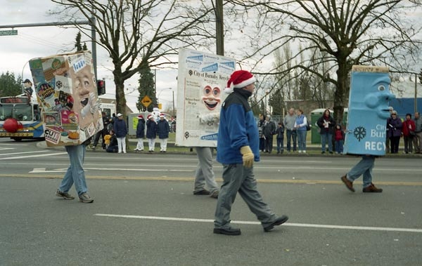
Edmonds parade
https://search.heritageburnaby.ca/link/archivedescription38558
- Repository
- City of Burnaby Archives
- Date
- November 27, 2003
- Collection/Fonds
- Burnaby Historical Society fonds
- Description Level
- File
- Physical Description
- 23 photographs : col. negatives ; 35 mm
- Scope and Content
- Photographs of the first Edmonds Christmas parade as it was seen travelling down Edmonds Street between Canada Way and Mary Avenue on November 27, 2003. Photographs show parade floats and groups walking in the parade with signs and costumes.
- Repository
- City of Burnaby Archives
- Date
- November 27, 2003
- Collection/Fonds
- Burnaby Historical Society fonds
- Subseries
- Pixie McGeachie subseries
- Physical Description
- 23 photographs : col. negatives ; 35 mm
- Description Level
- File
- Record No.
- 460-001
- Access Restriction
- No restrictions
- Reproduction Restriction
- Reproduce for fair dealing purposes only
- Accession Number
- BHS2004-02
- Scope and Content
- Photographs of the first Edmonds Christmas parade as it was seen travelling down Edmonds Street between Canada Way and Mary Avenue on November 27, 2003. Photographs show parade floats and groups walking in the parade with signs and costumes.
- Media Type
- Photograph
- Geographic Access
- Edmonds Street
- Mary Avenue
- Canada Way
- Planning Study Area
- Edmonds Area
Images