More like 'Backyard of 4447 Venables Street'
Narrow Results By
Decade
- 2020s
- 2010s 118
- 2000s 665
- 1990s 641
- 1980s 487
- 1970s 945
- 1960s 378
- 1950s 544
- 1940s 597
- 1930s 609
- 1920s 652
- 1910s 604
- 1900s 270
- 1890s 36
- 1880s 70
- 1870s 5
- 1860s 3
- 1850s 1
- 1840s 1
- 1830s 1
- 1820s 1
- 1810s 1
- 1800s 1
- 1790s 1
- 1780s 1
- 1770s 1
- 1760s 1
- 1750s 1
- 1740s 1
- 1730s 1
- 1720s 1
- 1710s 1
- 1700s 1
- 1690s 1
- 1680s 1
- 1670s 1
- 1660s 1
- 1650s 1
- 1640s 1
- 1630s 1
- 1620s 1
- 1610s 1
- 1600s 1

Savoy Place
https://search.heritageburnaby.ca/link/archivedescription98668
- Repository
- City of Burnaby Archives
- Date
- 2022
- Collection/Fonds
- Disappearing Burnaby collection
- Description Level
- Item
- Physical Description
- 1 photograph (jpeg) : col.
- Scope and Content
- Photograph of the exterior of Savoy Place, an apartment complex located at 6355 Kingsway, at night. The building was constructed in 1968. Two people are standing in the illuminated lobby of the building, and wings of the building flank either side of the entrance, with trees and bushes lining the s…
- Repository
- City of Burnaby Archives
- Date
- 2022
- Collection/Fonds
- Disappearing Burnaby collection
- Physical Description
- 1 photograph (jpeg) : col.
- Description Level
- Item
- Record No.
- 634-015
- Access Restriction
- No restrictions
- Reproduction Restriction
- No restrictions
- Accession Number
- 2022-14
- Scope and Content
- Photograph of the exterior of Savoy Place, an apartment complex located at 6355 Kingsway, at night. The building was constructed in 1968. Two people are standing in the illuminated lobby of the building, and wings of the building flank either side of the entrance, with trees and bushes lining the sidewalk.
- Media Type
- Photograph
- Photographer
- Cheung, Nakita
- Notes
- Title taken from the associated blog post
- Associated blog post: https://disappearingburnaby.wordpress.com/2022/05/19/savoy-place/
- Geographic Access
- Kingsway
- Street Address
- 6355 Kingsway
- Historic Neighbourhood
- East Burnaby (Historic Neighbourhood)
- Planning Study Area
- Kingsway-Beresford Area
Images


Silver Star Apartments
https://search.heritageburnaby.ca/link/archivedescription98679
- Repository
- City of Burnaby Archives
- Date
- 2022
- Collection/Fonds
- Disappearing Burnaby collection
- Description Level
- Item
- Physical Description
- 1 photograph (jpeg) : col.
- Scope and Content
- Photograph of the exterior and lawn of Silver Star Apartments, a low-rise apartment building located at 6425 Silver Avenue. The building was constructed in 1970. The photograph is taken from across a lawn and several trees and bushes are partially obscuring the building. A high-rise tower is visibl…
- Repository
- City of Burnaby Archives
- Date
- 2022
- Collection/Fonds
- Disappearing Burnaby collection
- Physical Description
- 1 photograph (jpeg) : col.
- Description Level
- Item
- Record No.
- 634-026
- Access Restriction
- No restrictions
- Reproduction Restriction
- No restrictions
- Accession Number
- 2022-14
- Scope and Content
- Photograph of the exterior and lawn of Silver Star Apartments, a low-rise apartment building located at 6425 Silver Avenue. The building was constructed in 1970. The photograph is taken from across a lawn and several trees and bushes are partially obscuring the building. A high-rise tower is visible behind the apartment building.
- Media Type
- Photograph
- Photographer
- Cheung, Nakita
- Notes
- Title taken from the associated blog post
- Associated blog post: https://disappearingburnaby.wordpress.com/2022/06/30/silver-star-apartments/
- Geographic Access
- Silver Avenue
- Street Address
- 6425 Silver Avenue
- Historic Neighbourhood
- Central Park (Historic Neighbourhood)
- Planning Study Area
- Maywood Area
Images


Star Light Apartments
https://search.heritageburnaby.ca/link/archivedescription98676
- Repository
- City of Burnaby Archives
- Date
- 2022
- Collection/Fonds
- Disappearing Burnaby collection
- Description Level
- Item
- Physical Description
- 1 photograph (jpeg) : col.
- Scope and Content
- Photograph of the entrance to Star Light Apartments, a low-rise apartment building located at 6555 Telford Avenue. The entrance is covered by a second-floor balcony and the lights are on inside; the plant-filled lobby and a large mirror visible through the front windows. The building was constructe…
- Repository
- City of Burnaby Archives
- Date
- 2022
- Collection/Fonds
- Disappearing Burnaby collection
- Physical Description
- 1 photograph (jpeg) : col.
- Description Level
- Item
- Record No.
- 634-023
- Access Restriction
- No restrictions
- Reproduction Restriction
- No restrictions
- Accession Number
- 2022-14
- Scope and Content
- Photograph of the entrance to Star Light Apartments, a low-rise apartment building located at 6555 Telford Avenue. The entrance is covered by a second-floor balcony and the lights are on inside; the plant-filled lobby and a large mirror visible through the front windows. The building was constructed in 1964.
- Media Type
- Photograph
- Photographer
- Cheung, Nakita
- Notes
- Title taken from the associated blog post
- Associated blog post: https://disappearingburnaby.wordpress.com/2022/06/24/star-light-apartments/
- Geographic Access
- Telford Avenue
- Street Address
- 6555 Telford Avenue
- Historic Neighbourhood
- Central Park (Historic Neighbourhood)
- Planning Study Area
- Maywood Area
Images


Star Light Apartments sign
https://search.heritageburnaby.ca/link/archivedescription98677
- Repository
- City of Burnaby Archives
- Date
- 2022
- Collection/Fonds
- Disappearing Burnaby collection
- Description Level
- Item
- Physical Description
- 1 photograph (jpeg) : col.
- Scope and Content
- Photograph of the Blue Sky Investments Ltd.'s sign on the lawn of Star Light Apartments, a low-rise apartment building located at 6555 Telford Avenue. The building was constructed in 1964. The photograph depicts the scene at dusk; the building's entrance is visible to the left, with its exterior li…
- Repository
- City of Burnaby Archives
- Date
- 2022
- Collection/Fonds
- Disappearing Burnaby collection
- Physical Description
- 1 photograph (jpeg) : col.
- Description Level
- Item
- Record No.
- 634-024
- Access Restriction
- No restrictions
- Reproduction Restriction
- No restrictions
- Accession Number
- 2022-14
- Scope and Content
- Photograph of the Blue Sky Investments Ltd.'s sign on the lawn of Star Light Apartments, a low-rise apartment building located at 6555 Telford Avenue. The building was constructed in 1964. The photograph depicts the scene at dusk; the building's entrance is visible to the left, with its exterior lights on, and Telford Avenue and other neighbouring towers are visible in the background.
- Subjects
- Buildings - Residential
- Buildings - Residential - Apartments
- Advertising Medium - Signs and Signboards
- Media Type
- Photograph
- Photographer
- Cheung, Nakita
- Notes
- Title taken from the associated blog post
- Associated blog post: https://disappearingburnaby.wordpress.com/2022/06/24/star-light-apartments/
- Geographic Access
- Telford Avenue
- Street Address
- 6555 Telford Avenue
- Historic Neighbourhood
- Central Park (Historic Neighbourhood)
- Planning Study Area
- Marlborough Area
Images


Sussex Ave Apartment
https://search.heritageburnaby.ca/link/archivedescription98657
- Repository
- City of Burnaby Archives
- Date
- 2022
- Collection/Fonds
- Disappearing Burnaby collection
- Description Level
- Item
- Physical Description
- 1 photograph (jpeg) : col.
- Scope and Content
- Photograph of the exterior of Sussex Ave Apartment, an apartment building located at 6749 Sussex Avenue. The building was constructed in 1958. The photograph depicts a fire escape between two storeys; the blinds are drawn on the apartments' windows, and one has a light shining within the apartment.
- Repository
- City of Burnaby Archives
- Date
- 2022
- Collection/Fonds
- Disappearing Burnaby collection
- Physical Description
- 1 photograph (jpeg) : col.
- Description Level
- Item
- Record No.
- 634-004
- Access Restriction
- No restrictions
- Reproduction Restriction
- No restrictions
- Accession Number
- 2022-14
- Scope and Content
- Photograph of the exterior of Sussex Ave Apartment, an apartment building located at 6749 Sussex Avenue. The building was constructed in 1958. The photograph depicts a fire escape between two storeys; the blinds are drawn on the apartments' windows, and one has a light shining within the apartment.
- Media Type
- Photograph
- Photographer
- Cheung, Nakita
- Notes
- Title taken from the associated blog post
- Associated blog post: https://disappearingburnaby.wordpress.com/2022/02/01/sussex-ave-apartment/
- Geographic Access
- Sussex Avenue
- Street Address
- 6749 Sussex Avenue
- Historic Neighbourhood
- Central Park (Historic Neighbourhood)
- Planning Study Area
- Maywood Area
Images


Sussex Court
https://search.heritageburnaby.ca/link/archivedescription98658
- Repository
- City of Burnaby Archives
- Date
- 2022
- Collection/Fonds
- Disappearing Burnaby collection
- Description Level
- Item
- Physical Description
- 1 photograph (jpeg) : col.
- Scope and Content
- Photograph of the exterior of Sussex Court, an apartment building located at 6780 Sussex Avenue. The photograph depicts the entire building from across the street at dusk. The building was constructed in 1954. Lights are shining through the central stairwell and a few of the apartments' windows.
- Repository
- City of Burnaby Archives
- Date
- 2022
- Collection/Fonds
- Disappearing Burnaby collection
- Physical Description
- 1 photograph (jpeg) : col.
- Description Level
- Item
- Record No.
- 634-005
- Access Restriction
- No restrictions
- Reproduction Restriction
- No restrictions
- Accession Number
- 2022-14
- Scope and Content
- Photograph of the exterior of Sussex Court, an apartment building located at 6780 Sussex Avenue. The photograph depicts the entire building from across the street at dusk. The building was constructed in 1954. Lights are shining through the central stairwell and a few of the apartments' windows.
- Media Type
- Photograph
- Photographer
- Cheung, Nakita
- Notes
- Title taken from the associated blog post
- Associated blog post: https://disappearingburnaby.wordpress.com/2022/02/02/sussex-court/
- Geographic Access
- Sussex Avenue
- Street Address
- 6780 Sussex Avenue
- Historic Neighbourhood
- Central Park (Historic Neighbourhood)
- Planning Study Area
- Maywood Area
Images


Sussex Villa
https://search.heritageburnaby.ca/link/archivedescription98659
- Repository
- City of Burnaby Archives
- Date
- 2022
- Collection/Fonds
- Disappearing Burnaby collection
- Description Level
- Item
- Physical Description
- 1 photograph (jpeg) : col.
- Scope and Content
- Photograph of part of the exterior and front lawn of Sussex Villa, an apartment complex located at 6620-6630 Sussex Avenue, at night. The building was constructed in 1965 and is set to be developed into a high-rise tower by Keltic Canada Development. A light is on inside one of the apartment window…
- Repository
- City of Burnaby Archives
- Date
- 2022
- Collection/Fonds
- Disappearing Burnaby collection
- Physical Description
- 1 photograph (jpeg) : col.
- Description Level
- Item
- Record No.
- 634-006
- Access Restriction
- No restrictions
- Reproduction Restriction
- No restrictions
- Accession Number
- 2022-14
- Scope and Content
- Photograph of part of the exterior and front lawn of Sussex Villa, an apartment complex located at 6620-6630 Sussex Avenue, at night. The building was constructed in 1965 and is set to be developed into a high-rise tower by Keltic Canada Development. A light is on inside one of the apartment windows and a sign for the "Metrotown - Regional Town Centre Notification of Area Plan" stands on the lawn.
- Subjects
- Buildings - Residential - Apartments
- Buildings - Residential
- Advertising Medium - Signs and Signboards
- Planning - City Planning
- Media Type
- Photograph
- Photographer
- Cheung, Nakita
- Notes
- Title taken from the associated blog post
- Associated blog post: https://disappearingburnaby.wordpress.com/2022/01/29/sussex-villa-2/
- Geographic Access
- Sussex Avenue
- Street Address
- 6620 Sussex Avenue
- 6630 Sussex Avenue
- Historic Neighbourhood
- Central Park (Historic Neighbourhood)
- Planning Study Area
- Maywood Area
Images


Sussex Villa with sign
https://search.heritageburnaby.ca/link/archivedescription98660
- Repository
- City of Burnaby Archives
- Date
- 2022
- Collection/Fonds
- Disappearing Burnaby collection
- Description Level
- Item
- Physical Description
- 1 photograph (jpeg) : col.
- Scope and Content
- Photograph of part of the exterior and front lawn of Sussex Villa, an apartment complex located at 6620-6630 Sussex Avenue, at night. The building was constructed in 1965 and is set to be developed into a high-rise tower by Keltic Canada Development. A sign standing on the lawn reads: "Land Loan" a…
- Repository
- City of Burnaby Archives
- Date
- 2022
- Collection/Fonds
- Disappearing Burnaby collection
- Physical Description
- 1 photograph (jpeg) : col.
- Description Level
- Item
- Record No.
- 634-007
- Access Restriction
- No restrictions
- Reproduction Restriction
- No restrictions
- Accession Number
- 2022-14
- Scope and Content
- Photograph of part of the exterior and front lawn of Sussex Villa, an apartment complex located at 6620-6630 Sussex Avenue, at night. The building was constructed in 1965 and is set to be developed into a high-rise tower by Keltic Canada Development. A sign standing on the lawn reads: "Land Loan" and "Domain Funding" with contact information, and a residential tower is visible in the background.
- Subjects
- Buildings - Residential - Apartments
- Buildings - Residential
- Advertising Medium - Signs and Signboards
- Media Type
- Photograph
- Photographer
- Cheung, Nakita
- Notes
- Title taken from the associated blog post
- Associated blog post: https://disappearingburnaby.wordpress.com/2022/01/29/sussex-villa-2/
- Geographic Access
- Sussex Avenue
- Street Address
- 6620 Sussex Avenue
- 6630 Sussex Avenue
- Historic Neighbourhood
- Central Park (Historic Neighbourhood)
- Planning Study Area
- Maywood Area
Images

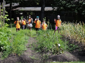
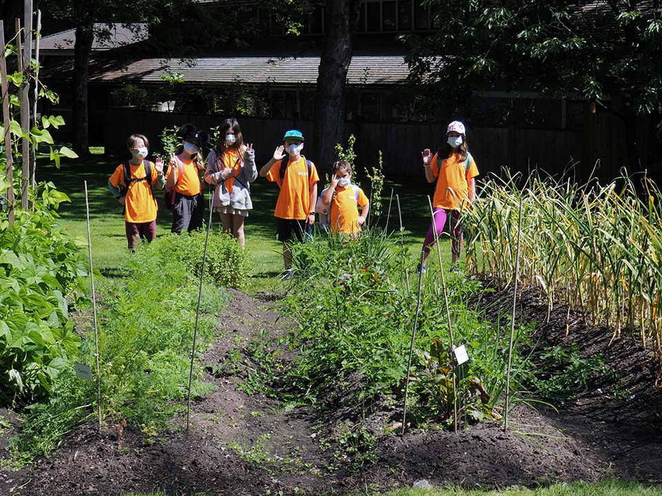
Kid's day camp at the market garden
https://search.heritageburnaby.ca/link/museumdescription14731
- Repository
- Burnaby Village Museum
- Date
- 14 July 2020
- Collection/Fonds
- Burnaby Village Museum COVID-19 collection
- Description Level
- Item
- Physical Description
- 1 photograph (jpg) : col. ; 350 dpi.
- Scope and Content
- Photograph of a kid's day camp group standing next to the market garden outside of the Love farmhouse at Burnaby Village Museum. The children are wearing masks that cover their mouths and noses and orange t-shirts. The Burnaby Village Museum adminstration building is visible in the background.
- Repository
- Burnaby Village Museum
- Collection/Fonds
- Burnaby Village Museum COVID-19 collection
- Description Level
- Item
- Physical Description
- 1 photograph (jpg) : col. ; 350 dpi.
- Scope and Content
- Photograph of a kid's day camp group standing next to the market garden outside of the Love farmhouse at Burnaby Village Museum. The children are wearing masks that cover their mouths and noses and orange t-shirts. The Burnaby Village Museum adminstration building is visible in the background.
- History
- Photograph was taken during the week of July 15th when Burnaby Village Museum was able to re-open to the public. The Museum was closed for most of it's seasonal schedule in 2020 due to the COVID-19 pandemic and public health orders. The Museum was able to re-open with restrictions for a shorter period.
- Names
- Burnaby Village Museum
- Accession Code
- BV020.19.3
- Access Restriction
- No restrictions
- Reproduction Restriction
- No known restrictions
- Date
- 14 July 2020
- Media Type
- Photograph
- Photographer
- Damer, Eric
- Notes
- Title based on contents of photograph
Images

Burnaby's COVID-19 drive thru testing site
https://search.heritageburnaby.ca/link/museumdescription15374
- Repository
- Burnaby Village Museum
- Date
- 5 Apr. 2020
- Collection/Fonds
- Burnaby Village Museum COVID-19 collection
- Description Level
- Item
- Physical Description
- 1 photograph (jpg)
- Scope and Content
- Photograph of the COVID-19 drive thru testing site in Central Park parking lot in Burnaby. Orange traffic posts and wayfinding signs are set up in the parking lot.
- Repository
- Burnaby Village Museum
- Collection/Fonds
- Burnaby Village Museum COVID-19 collection
- Description Level
- Item
- Physical Description
- 1 photograph (jpg)
- Scope and Content
- Photograph of the COVID-19 drive thru testing site in Central Park parking lot in Burnaby. Orange traffic posts and wayfinding signs are set up in the parking lot.
- Subjects
- Advertising Medium - Signs and Signboards
- Geographic Features - Parks
- Public Services - Health Services
- Pandemics - COVID-19
- Geographic Access
- Central Park
- Imperial Street
- Accession Code
- BV021.2.39
- Access Restriction
- No restrictions
- Reproduction Restriction
- May be restricted by third party rights
- Date
- 5 Apr. 2020
- Media Type
- Photograph
- Historic Neighbourhood
- Central Park (Historic Neighbourhood)
- Planning Study Area
- Maywood Area
- Notes
- Title based on contents of photograph
Images


Burnaby's COVID-19 drive thru testing site
https://search.heritageburnaby.ca/link/museumdescription15375
- Repository
- Burnaby Village Museum
- Date
- 5 Apr. 2020
- Collection/Fonds
- Burnaby Village Museum COVID-19 collection
- Description Level
- Item
- Physical Description
- 1 photograph (jpg)
- Scope and Content
- Photograph of the COVID-19 drive thru testing site in Central Park parking lot in Burnaby. Orange traffic posts, wayfinding signs and white tents are set up in the parking lot.
- Repository
- Burnaby Village Museum
- Collection/Fonds
- Burnaby Village Museum COVID-19 collection
- Description Level
- Item
- Physical Description
- 1 photograph (jpg)
- Scope and Content
- Photograph of the COVID-19 drive thru testing site in Central Park parking lot in Burnaby. Orange traffic posts, wayfinding signs and white tents are set up in the parking lot.
- Subjects
- Advertising Medium - Signs and Signboards
- Geographic Features - Parks
- Public Services - Health Services
- Pandemics - COVID-19
- Geographic Access
- Central Park
- Imperial Street
- Accession Code
- BV021.2.40
- Access Restriction
- No restrictions
- Reproduction Restriction
- May be restricted by third party rights
- Date
- 5 Apr. 2020
- Media Type
- Photograph
- Historic Neighbourhood
- Central Park (Historic Neighbourhood)
- Planning Study Area
- Maywood Area
- Notes
- Title based on contents of photograph
Images


Burnaby's COVID-19 drive thru testing site
https://search.heritageburnaby.ca/link/museumdescription15376
- Repository
- Burnaby Village Museum
- Date
- 5 Apr. 2020
- Collection/Fonds
- Burnaby Village Museum COVID-19 collection
- Description Level
- Item
- Physical Description
- 1 photograph (jpg)
- Scope and Content
- Photograph of the COVID-19 drive thru testing site in Central Park parking lot in Burnaby. Orange traffic posts, wayfinding signs and white tents are set up in the parking lot.
- Repository
- Burnaby Village Museum
- Collection/Fonds
- Burnaby Village Museum COVID-19 collection
- Description Level
- Item
- Physical Description
- 1 photograph (jpg)
- Scope and Content
- Photograph of the COVID-19 drive thru testing site in Central Park parking lot in Burnaby. Orange traffic posts, wayfinding signs and white tents are set up in the parking lot.
- Subjects
- Advertising Medium - Signs and Signboards
- Geographic Features - Parks
- Public Services - Health Services
- Pandemics - COVID-19
- Geographic Access
- Central Park
- Imperial Street
- Accession Code
- BV021.2.41
- Access Restriction
- No restrictions
- Reproduction Restriction
- May be restricted by third party rights
- Date
- 5 Apr. 2020
- Media Type
- Photograph
- Historic Neighbourhood
- Central Park (Historic Neighbourhood)
- Planning Study Area
- Maywood Area
- Notes
- Title based on contents of photograph
Images


Burnaby's COVID-19 drive thru testing site
https://search.heritageburnaby.ca/link/museumdescription15377
- Repository
- Burnaby Village Museum
- Date
- 5 Apr. 2020
- Collection/Fonds
- Burnaby Village Museum COVID-19 collection
- Description Level
- Item
- Physical Description
- 1 photograph (jpg)
- Scope and Content
- Photograph of the COVID-19 drive thru testing site in Central Park parking lot in Burnaby. Orange traffic posts, wayfinding signs and white tents are set up in the parking lot.
- Repository
- Burnaby Village Museum
- Collection/Fonds
- Burnaby Village Museum COVID-19 collection
- Description Level
- Item
- Physical Description
- 1 photograph (jpg)
- Scope and Content
- Photograph of the COVID-19 drive thru testing site in Central Park parking lot in Burnaby. Orange traffic posts, wayfinding signs and white tents are set up in the parking lot.
- Subjects
- Advertising Medium - Signs and Signboards
- Geographic Features - Parks
- Public Services - Health Services
- Pandemics - COVID-19
- Geographic Access
- Central Park
- Imperial Street
- Accession Code
- BV021.2.42
- Access Restriction
- No restrictions
- Reproduction Restriction
- May be restricted by third party rights
- Date
- 5 Apr. 2020
- Media Type
- Photograph
- Historic Neighbourhood
- Central Park (Historic Neighbourhood)
- Planning Study Area
- Maywood Area
- Notes
- Title based on contents of photograph
Images


Burnaby's COVID-19 drive thru testing site
https://search.heritageburnaby.ca/link/museumdescription15378
- Repository
- Burnaby Village Museum
- Date
- 5 Apr. 2020
- Collection/Fonds
- Burnaby Village Museum COVID-19 collection
- Description Level
- Item
- Physical Description
- 1 photograph (jpg)
- Scope and Content
- Photograph of the COVID-19 drive thru testing site in Central Park parking lot in Burnaby. Orange traffic posts, wayfinding signs and white tents are set up in the parking lot.
- Repository
- Burnaby Village Museum
- Collection/Fonds
- Burnaby Village Museum COVID-19 collection
- Description Level
- Item
- Physical Description
- 1 photograph (jpg)
- Scope and Content
- Photograph of the COVID-19 drive thru testing site in Central Park parking lot in Burnaby. Orange traffic posts, wayfinding signs and white tents are set up in the parking lot.
- Subjects
- Advertising Medium - Signs and Signboards
- Geographic Features - Parks
- Public Services - Health Services
- Pandemics - COVID-19
- Geographic Access
- Central Park
- Imperial Street
- Accession Code
- BV021.2.43
- Access Restriction
- No restrictions
- Reproduction Restriction
- May be restricted by third party rights
- Date
- 5 Apr. 2020
- Media Type
- Photograph
- Historic Neighbourhood
- Central Park (Historic Neighbourhood)
- Planning Study Area
- Maywood Area
- Notes
- Title based on contents of photograph
Images


Burnaby's COVID-19 drive thru testing site
https://search.heritageburnaby.ca/link/museumdescription15379
- Repository
- Burnaby Village Museum
- Date
- 5 Apr. 2020
- Collection/Fonds
- Burnaby Village Museum COVID-19 collection
- Description Level
- Item
- Physical Description
- 1 photograph (jpg)
- Scope and Content
- Photograph of the COVID-19 drive thru testing site in Central Park parking lot in Burnaby. Orange traffic posts, wayfinding signs, white tents and white buildings converted from shipping containers are set up in the parking lot.
- Repository
- Burnaby Village Museum
- Collection/Fonds
- Burnaby Village Museum COVID-19 collection
- Description Level
- Item
- Physical Description
- 1 photograph (jpg)
- Scope and Content
- Photograph of the COVID-19 drive thru testing site in Central Park parking lot in Burnaby. Orange traffic posts, wayfinding signs, white tents and white buildings converted from shipping containers are set up in the parking lot.
- Subjects
- Advertising Medium - Signs and Signboards
- Geographic Features - Parks
- Public Services - Health Services
- Pandemics - COVID-19
- Geographic Access
- Central Park
- Imperial Street
- Accession Code
- BV021.2.44
- Access Restriction
- No restrictions
- Reproduction Restriction
- May be restricted by third party rights
- Date
- 5 Apr. 2020
- Media Type
- Photograph
- Historic Neighbourhood
- Central Park (Historic Neighbourhood)
- Planning Study Area
- Maywood Area
- Notes
- Title based on contents of photograph
Images


Burnaby's COVID-19 drive thru testing site
https://search.heritageburnaby.ca/link/museumdescription15380
- Repository
- Burnaby Village Museum
- Date
- 5 Apr. 2020
- Collection/Fonds
- Burnaby Village Museum COVID-19 collection
- Description Level
- Item
- Physical Description
- 1 photograph (jpg)
- Scope and Content
- Photograph of the COVID-19 drive thru testing site in Central Park parking lot in Burnaby. Orange traffic posts, wayfinding signs and white tents are set up in the parking lot.
- Repository
- Burnaby Village Museum
- Collection/Fonds
- Burnaby Village Museum COVID-19 collection
- Description Level
- Item
- Physical Description
- 1 photograph (jpg)
- Scope and Content
- Photograph of the COVID-19 drive thru testing site in Central Park parking lot in Burnaby. Orange traffic posts, wayfinding signs and white tents are set up in the parking lot.
- Subjects
- Advertising Medium - Signs and Signboards
- Geographic Features - Parks
- Public Services - Health Services
- Pandemics - COVID-19
- Geographic Access
- Central Park
- Imperial Street
- Accession Code
- BV021.2.45
- Access Restriction
- No restrictions
- Reproduction Restriction
- May be restricted by third party rights
- Date
- 5 Apr. 2020
- Media Type
- Photograph
- Historic Neighbourhood
- Central Park (Historic Neighbourhood)
- Planning Study Area
- Maywood Area
- Notes
- Title based on contents of photograph
Images


Burnaby's COVID-19 drive thru testing site
https://search.heritageburnaby.ca/link/museumdescription15381
- Repository
- Burnaby Village Museum
- Date
- 5 Apr. 2020
- Collection/Fonds
- Burnaby Village Museum COVID-19 collection
- Description Level
- Item
- Physical Description
- 1 photograph (jpg)
- Scope and Content
- Photograph of the COVID-19 drive thru testing site in Central Park parking lot in Burnaby. Orange traffic posts, wayfinding signs and white tents are set up in the parking lot.
- Repository
- Burnaby Village Museum
- Collection/Fonds
- Burnaby Village Museum COVID-19 collection
- Description Level
- Item
- Physical Description
- 1 photograph (jpg)
- Scope and Content
- Photograph of the COVID-19 drive thru testing site in Central Park parking lot in Burnaby. Orange traffic posts, wayfinding signs and white tents are set up in the parking lot.
- Subjects
- Advertising Medium - Signs and Signboards
- Geographic Features - Parks
- Public Services - Health Services
- Pandemics - COVID-19
- Geographic Access
- Central Park
- Imperial Street
- Accession Code
- BV021.2.46
- Access Restriction
- No restrictions
- Reproduction Restriction
- May be restricted by third party rights
- Date
- 5 Apr. 2020
- Media Type
- Photograph
- Historic Neighbourhood
- Central Park (Historic Neighbourhood)
- Planning Study Area
- Maywood Area
- Notes
- Title based on contents of photograph
Images


Burnaby's COVID-19 drive thru testing site
https://search.heritageburnaby.ca/link/museumdescription15382
- Repository
- Burnaby Village Museum
- Date
- 5 Apr. 2020
- Collection/Fonds
- Burnaby Village Museum COVID-19 collection
- Description Level
- Item
- Physical Description
- 1 photograph (jpg)
- Scope and Content
- Photograph of the COVID-19 drive thru testing site in Central Park parking lot in Burnaby. White shipping container buildings have been set up in the parking lot.
- Repository
- Burnaby Village Museum
- Collection/Fonds
- Burnaby Village Museum COVID-19 collection
- Description Level
- Item
- Physical Description
- 1 photograph (jpg)
- Scope and Content
- Photograph of the COVID-19 drive thru testing site in Central Park parking lot in Burnaby. White shipping container buildings have been set up in the parking lot.
- Subjects
- Advertising Medium - Signs and Signboards
- Geographic Features - Parks
- Public Services - Health Services
- Pandemics - COVID-19
- Geographic Access
- Central Park
- Imperial Street
- Accession Code
- BV021.2.47
- Access Restriction
- No restrictions
- Reproduction Restriction
- May be restricted by third party rights
- Date
- 5 Apr. 2020
- Media Type
- Photograph
- Historic Neighbourhood
- Central Park (Historic Neighbourhood)
- Planning Study Area
- Maywood Area
- Notes
- Title based on contents of photograph
Images


Burnaby's COVID-19 drive thru testing site
https://search.heritageburnaby.ca/link/museumdescription15383
- Repository
- Burnaby Village Museum
- Date
- 5 Apr. 2020
- Collection/Fonds
- Burnaby Village Museum COVID-19 collection
- Description Level
- Item
- Physical Description
- 1 photograph (jpg)
- Scope and Content
- Photograph of the COVID-19 drive thru testing site in Central Park parking lot in Burnaby. White shipping container buildings have been set up in the parking lot.
- Repository
- Burnaby Village Museum
- Collection/Fonds
- Burnaby Village Museum COVID-19 collection
- Description Level
- Item
- Physical Description
- 1 photograph (jpg)
- Scope and Content
- Photograph of the COVID-19 drive thru testing site in Central Park parking lot in Burnaby. White shipping container buildings have been set up in the parking lot.
- Subjects
- Advertising Medium - Signs and Signboards
- Geographic Features - Parks
- Public Services - Health Services
- Pandemics - COVID-19
- Geographic Access
- Central Park
- Imperial Street
- Accession Code
- BV021.2.48
- Access Restriction
- No restrictions
- Reproduction Restriction
- May be restricted by third party rights
- Date
- 5 Apr. 2020
- Media Type
- Photograph
- Historic Neighbourhood
- Central Park (Historic Neighbourhood)
- Planning Study Area
- Maywood Area
- Notes
- Title based on contents of photograph
Images


Burnaby's COVID-19 drive thru testing site
https://search.heritageburnaby.ca/link/museumdescription15391
- Repository
- Burnaby Village Museum
- Date
- 27 Apr. 2020
- Collection/Fonds
- Burnaby Village Museum COVID-19 collection
- Description Level
- Item
- Physical Description
- 1 video recording (mp4) (17 sec.) : digital, 24 fps, col., si.
- Scope and Content
- Film clip (no sound) of the COVID-19 drive thru testing site in Central Park parking lot in Burnaby. Orange traffic posts, wayfinding signs and white tents are set up in the parking lot and staff are wearing protective face masks.
- Repository
- Burnaby Village Museum
- Collection/Fonds
- Burnaby Village Museum COVID-19 collection
- Description Level
- Item
- Physical Description
- 1 video recording (mp4) (17 sec.) : digital, 24 fps, col., si.
- Scope and Content
- Film clip (no sound) of the COVID-19 drive thru testing site in Central Park parking lot in Burnaby. Orange traffic posts, wayfinding signs and white tents are set up in the parking lot and staff are wearing protective face masks.
- Subjects
- Advertising Medium - Signs and Signboards
- Geographic Features - Parks
- Public Services - Health Services
- Pandemics - COVID-19
- Geographic Access
- Central Park
- Imperial Street
- Accession Code
- BV021.2.8
- Access Restriction
- No restrictions
- Reproduction Restriction
- May be restricted by third party rights
- Date
- 27 Apr. 2020
- Media Type
- Moving Images
- Historic Neighbourhood
- Central Park (Historic Neighbourhood)
- Planning Study Area
- Maywood Area
- Notes
- Title based on contents of photograph
Images

Video
Burnaby's COVID-19 drive thru testing site, 27 Apr. 2020
Burnaby's COVID-19 drive thru testing site, 27 Apr. 2020
https://search.heritageburnaby.ca/media/hpo/_Data/_BVM_Moving_Images/2021_0002_0008_001.mp4