Janet's Story
https://search.heritageburnaby.ca/link/museumdescription9671
- Repository
- Burnaby Village Museum
- Date
- 2016
- Collection/Fonds
- Burnaby Village Museum Film and Video collection
- Description Level
- Item
- Physical Description
- 1 video recording (mp4) (4 min., 7 sec.) : digital, 25 fps, col., sd., stereo
- Scope and Content
- Film created by Janet Duxbury, who grew up in Burnaby, north of Imperial Street. Janet recounts her family's house that was built in 1940 and had no water or electricity during the early years. The family had chickens, vegetable gardens and used an outhouse until an addition was built a few years l…
- Repository
- Burnaby Village Museum
- Collection/Fonds
- Burnaby Village Museum Film and Video collection
- Description Level
- Item
- Physical Description
- 1 video recording (mp4) (4 min., 7 sec.) : digital, 25 fps, col., sd., stereo
- Scope and Content
- Film created by Janet Duxbury, who grew up in Burnaby, north of Imperial Street. Janet recounts her family's house that was built in 1940 and had no water or electricity during the early years. The family had chickens, vegetable gardens and used an outhouse until an addition was built a few years later. Janet played in the woods by the house as a child. Janet recounts swimming at Deer Lake Lake and walking past Oakalla Prison on the way. Janet attended Windsor Street School. She recounts visiting the Carneige Library in Vancouver and the Burnaby Public Library with her cousin.
- History
- Janet Duxbury grew up in Burnaby, north of Imperial Street. She attended Windsor Street School in Burnaby.
- Creator
- Duxbury, Janet
- Other Title Information
- title supplied by film maker
- Names
- Duxbury, Janet
- Geographic Access
- Imperial Street
- Deer Lake
- Accession Code
- BV016.37.2
- Access Restriction
- No restrictions
- Reproduction Restriction
- May be restricted by third party rights
- Date
- 2016
- Media Type
- Moving Images
- Notes
- Transcribed title
- The film was produced in 2016 as part of the Elders Digital Storytelling project. Digital storytelling is a form of narrative that creates short movies using relatively simple media technology. The project began in 2014 funded by the Social Sciences and Humanities Council of Canada (SSHRC) and AGE-WELL NCE grants. In partnership with the City of Burnaby, digital storytelling workshops were offered in Burnaby. This film was produced at one of those workshops.
Images
Video
Janet's Story, 2016
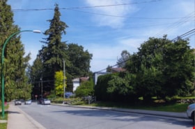
Looking east along Dominion street to corner of Douglas Road and Dominion Street
https://search.heritageburnaby.ca/link/archivedescription91876
- Repository
- City of Burnaby Archives
- Date
- 2016
- Collection/Fonds
- Small family fonds
- Description Level
- Item
- Physical Description
- 1 photograph : col. ; 10 cm x 15 cm
- Scope and Content
- Photograph of Dominion Street, looking east. The houses are largely obscured by tall hedges and bushes. The photograph was taken from the north side of the street, opposite 5496 Dominion Street.
- Repository
- City of Burnaby Archives
- Date
- 2016
- Collection/Fonds
- Small family fonds
- Physical Description
- 1 photograph : col. ; 10 cm x 15 cm
- Description Level
- Item
- Record No.
- 620-057
- Access Restriction
- No restrictions
- Reproduction Restriction
- No reproduction permitted
- Accession Number
- 2017-01
- Scope and Content
- Photograph of Dominion Street, looking east. The houses are largely obscured by tall hedges and bushes. The photograph was taken from the north side of the street, opposite 5496 Dominion Street.
- Media Type
- Photograph
- Notes
- Transcribed title
- Title transcribed from donor's notes
- Note in blue ink on verso of photograph reads: "P.19"
- Note in blue ink on verso of photograph reads: "2016 / Looking East along Dominion St to corner of Douglas Rd. and Dominion St."
- Photograph 620-056 taken from the same vantage point
- Geographic Access
- Dominion Street
- Street Address
- 5538 Dominion Street
- Historic Neighbourhood
- Burnaby Lake (Historic Neighbourhood)
- Planning Study Area
- Ardingley-Sprott Area
Images
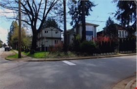
Looking southwest from corner of Douglas Road and Dominion Street
https://search.heritageburnaby.ca/link/archivedescription91878
- Repository
- City of Burnaby Archives
- Date
- April 2015
- Collection/Fonds
- Small family fonds
- Description Level
- Item
- Physical Description
- 1 photograph : col. copy print ; 10 cm x 15 cm
- Scope and Content
- Photograph of the houses and trees situated on the southwest corner of Douglas Road and Dominion Street. The large oak, hemlock, and fir were planted as part of the original landscaping of the Roberts' property in the 1920s. The photograph was taken from the Douglas Road and Dominion Street inter…
- Repository
- City of Burnaby Archives
- Date
- April 2015
- Collection/Fonds
- Small family fonds
- Physical Description
- 1 photograph : col. copy print ; 10 cm x 15 cm
- Description Level
- Item
- Record No.
- 620-059
- Access Restriction
- No restrictions
- Reproduction Restriction
- No reproduction permitted
- Accession Number
- 2017-01
- Scope and Content
- Photograph of the houses and trees situated on the southwest corner of Douglas Road and Dominion Street. The large oak, hemlock, and fir were planted as part of the original landscaping of the Roberts' property in the 1920s. The photograph was taken from the Douglas Road and Dominion Street intersection.
- Media Type
- Photograph
- Notes
- Transcribed title
- Title transcribed from donor's notes
- Note in blue ink on verso of photograph reads: "P.21"
- Note in blue ink on verso of photograph reads: "Looking southwest from corner of Douglas Rd. and Dominion St. / Oak Tree Hemlock Tree Fir Tree / planted in late 1920's"
- Note in black ink on verso of photograph reads: "April 2015"
- The oak tree is the same tree as in photographs 620-007, 620-014, 620-015, and 620-016
- Geographic Access
- Dominion Street
- Douglas Road
- Historic Neighbourhood
- Burnaby Lake (Historic Neighbourhood)
- Planning Study Area
- Ardingley-Sprott Area
Images
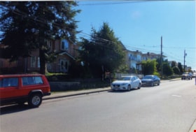
Looking west along Dominion Street from across the street from 5496 Dominion Street
https://search.heritageburnaby.ca/link/archivedescription91874
- Repository
- City of Burnaby Archives
- Date
- July 2016
- Collection/Fonds
- Small family fonds
- Description Level
- Item
- Physical Description
- 1 photograph : col. copy print ; 10 cm x 15 cm
- Scope and Content
- Photograph of the houses along the south side of Dominion Street with cars parked along the curb. In 2009 sidewalks were installed and the street was repaved under a neighbourhood local improvement request to the City. The photograph was taken from the north side of the street, opposite 5496 Dom…
- Repository
- City of Burnaby Archives
- Date
- July 2016
- Collection/Fonds
- Small family fonds
- Physical Description
- 1 photograph : col. copy print ; 10 cm x 15 cm
- Description Level
- Item
- Record No.
- 620-055
- Access Restriction
- No restrictions
- Reproduction Restriction
- No reproduction permitted
- Accession Number
- 2017-01
- Scope and Content
- Photograph of the houses along the south side of Dominion Street with cars parked along the curb. In 2009 sidewalks were installed and the street was repaved under a neighbourhood local improvement request to the City. The photograph was taken from the north side of the street, opposite 5496 Dominion Street, looking west.
- Media Type
- Photograph
- Notes
- Transcribed title
- Title transcribed from donor's notes
- Note in blue ink on verso of photograph reads: "P.17"
- Note in blue ink on verso of photograph reads: "Dominion St. infilled with houses on 33' lots / Photo July 2016"
- Geographic Access
- Dominion Street
- Historic Neighbourhood
- Burnaby Lake (Historic Neighbourhood)
- Planning Study Area
- Ardingley-Sprott Area
Images
Looking west from back yard of 5496 Dominion Street
https://search.heritageburnaby.ca/link/archivedescription91866
- Repository
- City of Burnaby Archives
- Date
- April 1, 2015
- Collection/Fonds
- Small family fonds
- Description Level
- Item
- Physical Description
- 1 photograph : col. copy print ; 10 cm x 15 cm
- Scope and Content
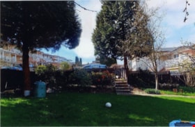
- Photograph of the backyard at 5496 Dominion Street, looking west, with the houses on Norfolk Street (left) and Dominion Street (right) visible in the background.
- Repository
- City of Burnaby Archives
- Date
- April 1, 2015
- Collection/Fonds
- Small family fonds
- Physical Description
- 1 photograph : col. copy print ; 10 cm x 15 cm
- Description Level
- Item
- Record No.
- 620-047
- Access Restriction
- No restrictions
- Reproduction Restriction
- No reproduction permitted
- Accession Number
- 2017-01
- Scope and Content
- Photograph of the backyard at 5496 Dominion Street, looking west, with the houses on Norfolk Street (left) and Dominion Street (right) visible in the background.
- Media Type
- Photograph
- Notes
- Transcribed title
- Title transcribed from donor's notes
- Note in blue ink on verso of photograph reads: "P.10"
- Note in black ink on verso of photograph reads: "April 1, 2015"
- Geographic Access
- Dominion Street
- Norfolk Street
- Street Address
- 5496 Dominion Street
- Historic Neighbourhood
- Burnaby Lake (Historic Neighbourhood)
- Planning Study Area
- Ardingley-Sprott Area
