
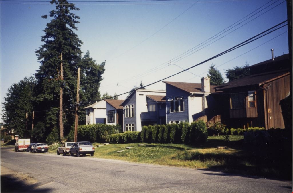
Looking east along Dominion street to corner of Douglas Road and Dominion Street
https://search.heritageburnaby.ca/link/archivedescription91875
- Repository
- City of Burnaby Archives
- Date
- 1991
- Collection/Fonds
- Small family fonds
- Description Level
- Item
- Physical Description
- 1 photograph : col. copy print ; 10 cm x 15 cm
- Scope and Content
- Photograph of houses along Dominion Street, looking east with a tall hemlock, fir, and oak tree in the background. These houses were built after the Roberts' house was moved from 5538 Dominion Street to 5496 Dominion Street in 1982. The trees are the only three remaining from the original landsca…
- Repository
- City of Burnaby Archives
- Date
- 1991
- Collection/Fonds
- Small family fonds
- Physical Description
- 1 photograph : col. copy print ; 10 cm x 15 cm
- Description Level
- Item
- Record No.
- 620-056
- Access Restriction
- No restrictions
- Reproduction Restriction
- No reproduction permitted
- Accession Number
- 2017-01
- Scope and Content
- Photograph of houses along Dominion Street, looking east with a tall hemlock, fir, and oak tree in the background. These houses were built after the Roberts' house was moved from 5538 Dominion Street to 5496 Dominion Street in 1982. The trees are the only three remaining from the original landscaping of the Roberts' property in the late 1920s. The photograph was taken from the north side of the street, opposite 5496 Dominion Street.
- Media Type
- Photograph
- Notes
- Transcribed title
- Title transcribed from donor's notes
- Note in blue ink on verso of photograph reads: "P.18"
- Note in blue ink on verso of photograph reads: "Dominion St Summer 1991"
- The oak tree is the same tree as in photographs 620-007, 620-014, 620-015, and 620-016
- Geographic Access
- Dominion Street
- Street Address
- 5538 Dominion Street
- Historic Neighbourhood
- Burnaby Lake (Historic Neighbourhood)
- Planning Study Area
- Ardingley-Sprott Area
Images
![Landscape plan for front yard of Mawhinney house, [between 1988 and 1990] thumbnail](/media/hpo/_Data/_BVM_Architectural_Drawings/2018_0009_0049_001.jpg?width=280)
Landscape plan for front yard of Mawhinney house
https://search.heritageburnaby.ca/link/museumdescription15583
- Repository
- Burnaby Village Museum
- Date
- [between 1988 and 1990]
- Collection/Fonds
- Reverend Edward S. Gale fonds
- Description Level
- Item
- Physical Description
- 1 architectural drawing : blueline print with pencil ; 42.5 x 59.5 cm
- Scope and Content
- Item consists of an architectural landscape plan identifying the layout and types of trees and bushes to be planted in the front yard of the Mervin Mawhinney house located at 7667 Burris Street in Burnaby while it was owned by Reverend Edward S. Gale. Plantings identified include; Juniper, Rhodendr…
- Repository
- Burnaby Village Museum
- Collection/Fonds
- Reverend Edward S. Gale fonds
- Description Level
- Item
- Physical Description
- 1 architectural drawing : blueline print with pencil ; 42.5 x 59.5 cm
- Scope and Content
- Item consists of an architectural landscape plan identifying the layout and types of trees and bushes to be planted in the front yard of the Mervin Mawhinney house located at 7667 Burris Street in Burnaby while it was owned by Reverend Edward S. Gale. Plantings identified include; Juniper, Rhodendron, Azaleas, abelia, Rosh Rogos. Grounds on the site were re-landscaped by Reverend Edward S. Gale between 1988 and 1990.
- Geographic Access
- Burris Street
- Street Address
- 7667 Burris Street
- Accession Code
- BV018.9.49
- Access Restriction
- No restrictions
- Reproduction Restriction
- May be restricted by third party rights
- Date
- [between 1988 and 1990]
- Media Type
- Architectural Drawing
- Planning Study Area
- Morley-Buckingham Area
- Related Material
- See also BV018.9.30
- Scan Resolution
- 600
- Scan Date
- May 3, 2021
- Scale
- 100
- Notes
- Title based on contents of photograph
Images
![Landscape plan for front yard of Mawhinney house, [between 1988 and 1990] thumbnail](/media/hpo/_Data/_BVM_Architectural_Drawings/2018_0009_0049_001.jpg)
![Environment Week at Terminus Park, [1999] thumbnail](/media/hpo/_Data/_Archives_Images/_Unrestricted/535/535-3201.jpg?width=280)
Environment Week at Terminus Park
https://search.heritageburnaby.ca/link/archivedescription98122
- Repository
- City of Burnaby Archives
- Date
- [1999]
- Collection/Fonds
- Burnaby NewsLeader photograph collection
- Description Level
- Item
- Physical Description
- 1 photograph (tiff) : col.
- Scope and Content
- Photograph of Clinton Elementary School students Felipe Castaneda and Corey Itterman pulling out purple loosestrife from around a pond in Terminus Park (Burnaby Fraser Foreshore Park), during Burnaby's Environment Week celebrations.
- Repository
- City of Burnaby Archives
- Date
- [1999]
- Collection/Fonds
- Burnaby NewsLeader photograph collection
- Physical Description
- 1 photograph (tiff) : col.
- Description Level
- Item
- Record No.
- 535-3201
- Access Restriction
- No restrictions
- Reproduction Restriction
- No restrictions
- Accession Number
- 2018-12
- Scope and Content
- Photograph of Clinton Elementary School students Felipe Castaneda and Corey Itterman pulling out purple loosestrife from around a pond in Terminus Park (Burnaby Fraser Foreshore Park), during Burnaby's Environment Week celebrations.
- Media Type
- Photograph
- Photographer
- Bartel, Mario
- Notes
- Title based on caption
- Collected by editorial for use in a June 1999 issue of the Burnaby NewsLeader
- Caption from metadata: "Felipe Castaneda, 12, and Corey Itterman, 12, team up to pull out purple loosestrife, from around the ponds at Terminus Park. They were part of a team of students from Clinton Elementary, and Douglas College, pulling weeds and planting new grasses and bushes at the fledgling park, as part of Burnaby's Environment Week celebrations."
- Geographic Access
- Burnaby Fraser Foreshore Park
- Historic Neighbourhood
- Fraser Arm (Historic Neighbourhood)
- Planning Study Area
- Big Bend Area
Images
![Environment Week at Terminus Park, [1999] thumbnail](/media/hpo/_Data/_Archives_Images/_Unrestricted/535/535-3201.jpg)
![Landscape plan for front yard of Mawhinney house, [between 1988 and 1990] thumbnail](/media/hpo/_Data/_BVM_Architectural_Drawings/2018_0009_0048_001.jpg?width=280)
Landscape plan for front yard of Mawhinney house
https://search.heritageburnaby.ca/link/museumdescription15582
- Repository
- Burnaby Village Museum
- Date
- [between 1988 and 1990]
- Collection/Fonds
- Reverend Edward S. Gale fonds
- Description Level
- Item
- Physical Description
- 1 architectural drawing : pencil on parchment ; 30 x 56 cm
- Scope and Content
- Item consists of a landscape drawing identifying the layout and types of trees and bushes to be planted on the property of the Mervin Mawhinney house located at 7667 Burris Street in Burnaby while it was owned by Reverend Edward S. Gale. Grounds on the site were re-landscaped by Reverend Edward S. …
- Repository
- Burnaby Village Museum
- Collection/Fonds
- Reverend Edward S. Gale fonds
- Description Level
- Item
- Physical Description
- 1 architectural drawing : pencil on parchment ; 30 x 56 cm
- Scope and Content
- Item consists of a landscape drawing identifying the layout and types of trees and bushes to be planted on the property of the Mervin Mawhinney house located at 7667 Burris Street in Burnaby while it was owned by Reverend Edward S. Gale. Grounds on the site were re-landscaped by Reverend Edward S. Gale between 1988 and 1990..
- Geographic Access
- Burris Street
- Street Address
- 7667 Burris Street
- Accession Code
- BV018.9.48
- Access Restriction
- No restrictions
- Reproduction Restriction
- May be restricted by third party rights
- Date
- [between 1988 and 1990]
- Media Type
- Architectural Drawing
- Planning Study Area
- Morley-Buckingham Area
- Scan Resolution
- 600
- Scan Date
- May 3, 2021
- Scale
- 100
- Notes
- Title based on contents of photograph
Images
![Landscape plan for front yard of Mawhinney house, [between 1988 and 1990] thumbnail](/media/hpo/_Data/_BVM_Architectural_Drawings/2018_0009_0048_001.jpg)