More like 'The Men's Quarters'
Narrow Results By
Subject
- Advertising Medium - Signs and Signboards 4
- Agriculture - Farms 1
- Animals - Birds 1
- Animals - Dogs 1
- Buildings 1
- Buildings - Agricultural - Nurseries 1
- Buildings - Civic - Hospitals 2
- Buildings - Civic - Museums 3
- Buildings - Commercial 41
- Buildings - Commercial - Automobile Dealerships 3
- Buildings - Commercial - Barber Shops 1
- Buildings - Commercial - Beauty Shops 1

North Fraser Harbour Commission / Fraser River
https://search.heritageburnaby.ca/link/archivedescription91706
- Repository
- City of Burnaby Archives
- Date
- May 25, 1994
- Collection/Fonds
- Doreen Lawson fonds
- Description Level
- File
- Physical Description
- 40 photographs : col. slides ; 35 mm + 65 photographs : col. negatives ; 35 mm
- Scope and Content
- File consists of photographs of the Fraser River. Sawmills and industrial buildings line the banks of the river which is populated with tugboats, drifting timber rafts, and sawdust barges. Photographs were taken from a boat travelling down the river and the bow of the boat is visible in one of th…
- Repository
- City of Burnaby Archives
- Date
- May 25, 1994
- Collection/Fonds
- Doreen Lawson fonds
- Physical Description
- 40 photographs : col. slides ; 35 mm + 65 photographs : col. negatives ; 35 mm
- Description Level
- File
- Record No.
- 618-024
- Access Restriction
- No restrictions
- Reproduction Restriction
- Reproduce for fair dealing purposes only
- Accession Number
- 2015-15
- Scope and Content
- File consists of photographs of the Fraser River. Sawmills and industrial buildings line the banks of the river which is populated with tugboats, drifting timber rafts, and sawdust barges. Photographs were taken from a boat travelling down the river and the bow of the boat is visible in one of the photographs.
- Media Type
- Photograph
- Notes
- Transcribed title
- Title transcribed from label on slide sheets
- Note in blue ink on recto of slide sheets photographs 618-024-001 : 618-024-15 and 618-024-27 : 618-024-38 were originally housed in read: "May 25 94 / North Fraser Harbour Commission / Fraser River"
- Note in blue ink on recto of slide sheet photographs 618-024-16 : 618-024-26 were originally housed in reads: "May 25 94 / North Fraser Harbour Commission / Fraser River / Irene Frith"
- Note in blue ink on slide sheet photographs 618-039 : 618-039-40 originally housed in read: "Fraser River / May 25 94"
- Note in blue ink on negative envelopes reads: "Fraser River / May 25 94"
- Geographic Access
- Fraser River
- Historic Neighbourhood
- Fraser Arm (Historic Neighbourhood)
- Planning Study Area
- Big Bend Area
Images

6900 [and] 7000 bk Hastings St. / 7000 blk Pandora St. 200 [and] 300 blks Cliff Ave Burnaby
https://search.heritageburnaby.ca/link/archivedescription94205
- Repository
- City of Burnaby Archives
- Date
- November 1993 - December 1993
- Collection/Fonds
- Grover, Elliott & Co. Ltd. fonds
- Description Level
- File
- Physical Description
- 96 photographs : col. negatives ; 35 mm
- Scope and Content
- Photographs of various residential and commercial streets in Burnaby.
- Repository
- City of Burnaby Archives
- Date
- November 1993 - December 1993
- Collection/Fonds
- Grover, Elliott & Co. Ltd. fonds
- Physical Description
- 96 photographs : col. negatives ; 35 mm
- Description Level
- File
- Record No.
- 622-080
- Access Restriction
- No restrictions
- Reproduction Restriction
- No restrictions
- Accession Number
- 2017-39
- Scope and Content
- Photographs of various residential and commercial streets in Burnaby.
- Subjects
- Geographic Features - Roads
- Buildings - Residential - Apartments
- Buildings - Residential - Houses
- Buildings - Commercial
- Media Type
- Photograph
- Notes
- Transcribed title
- Title transcribed from envelope photographs were originally housed in
- File no. 93-455-B
- Note on negative envelope housing photographs 622-080-1 : 622-080-74 reads: "93-11-26 / Inlet Dr/Hastings, Bby, / 93-455-B"
- Note on negative envelope housing photographs 622-080-75 : 622-080-96 reads: "93-12-01 / Comp's / 93-455"
- Photographer identified as "K.H."
- Geographic Access
- Hastings Street
- Cliff Avenue
- Pandora Street
7365 CA Way Burnaby
https://search.heritageburnaby.ca/link/archivedescription94310
- Repository
- City of Burnaby Archives
- Date
- May 1994
- Collection/Fonds
- Grover, Elliott & Co. Ltd. fonds
- Description Level
- File
- Physical Description
- 40 photographs : col. negatives ; 35 mm
- Scope and Content
- Photographs of low-rise apartments and single-family homes along the 7300 block of Canaday Way, including a two-storey apartment complex at 7365 Canada Way.
- Repository
- City of Burnaby Archives
- Date
- May 1994
- Collection/Fonds
- Grover, Elliott & Co. Ltd. fonds
- Physical Description
- 40 photographs : col. negatives ; 35 mm
- Description Level
- File
- Record No.
- 622-095
- Access Restriction
- No restrictions
- Reproduction Restriction
- No restrictions
- Accession Number
- 2017-39
- Scope and Content
- Photographs of low-rise apartments and single-family homes along the 7300 block of Canaday Way, including a two-storey apartment complex at 7365 Canada Way.
- Media Type
- Photograph
- Notes
- Transcribed title
- Title transcribed from envelope photographs were originally housed in
- File no. 94-181-B
- Photographer identified as "L.D."
- Geographic Access
- Canada Way
- Street Address
- 7365 Canada Way
- Historic Neighbourhood
- Edmonds (Historic Neighbourhood)
- Planning Study Area
- Edmonds Area
4390 Grange Street, Bby [sic]
https://search.heritageburnaby.ca/link/archivedescription94319
- Repository
- City of Burnaby Archives
- Date
- September 1994
- Collection/Fonds
- Grover, Elliott & Co. Ltd. fonds
- Description Level
- File
- Physical Description
- 22 photographs : col. negatives ; 35 mm
- Scope and Content
- Photographs of the exterior of a high-rise apartment complex located at 4390 Grange Street.
- Repository
- City of Burnaby Archives
- Date
- September 1994
- Collection/Fonds
- Grover, Elliott & Co. Ltd. fonds
- Physical Description
- 22 photographs : col. negatives ; 35 mm
- Description Level
- File
- Record No.
- 622-104
- Access Restriction
- No restrictions
- Reproduction Restriction
- No restrictions
- Accession Number
- 2017-39
- Scope and Content
- Photographs of the exterior of a high-rise apartment complex located at 4390 Grange Street.
- Subjects
- Buildings - Residential - Apartments
- Media Type
- Photograph
- Notes
- Transcribed title
- Title transcribed from envelope photographs were originally housed in
- File no. 94-353-B
- Geographic Access
- Grange Street
- Street Address
- 4390 Grange Street
- Historic Neighbourhood
- Central Park (Historic Neighbourhood)
- Planning Study Area
- Maywood Area
4411 Grange St.
https://search.heritageburnaby.ca/link/archivedescription94338
- Repository
- City of Burnaby Archives
- Date
- June 1995
- Collection/Fonds
- Grover, Elliott & Co. Ltd. fonds
- Description Level
- File
- Physical Description
- 22 photographs : col. negatives ; 35 mm
- Scope and Content
- Photographs of the exterior of a three-storey apartment building located at 4411 Grange Street.
- Repository
- City of Burnaby Archives
- Date
- June 1995
- Collection/Fonds
- Grover, Elliott & Co. Ltd. fonds
- Physical Description
- 22 photographs : col. negatives ; 35 mm
- Description Level
- File
- Record No.
- 622-123
- Access Restriction
- No restrictions
- Reproduction Restriction
- No restrictions
- Accession Number
- 2017-39
- Scope and Content
- Photographs of the exterior of a three-storey apartment building located at 4411 Grange Street.
- Subjects
- Buildings - Residential - Apartments
- Media Type
- Photograph
- Photographer
- Young, Richard
- Notes
- Transcribed title
- Title transcribed from envelope photographs were originally housed in
- File no. 95-228-B
- Geographic Access
- Grange Street
- Street Address
- 4411 Grange Street
- Historic Neighbourhood
- Central Park (Historic Neighbourhood)
- Planning Study Area
- Garden Village Area
4955-4957 Newton St.
https://search.heritageburnaby.ca/link/archivedescription94325
- Repository
- City of Burnaby Archives
- Date
- November 1994
- Collection/Fonds
- Grover, Elliott & Co. Ltd. fonds
- Description Level
- File
- Physical Description
- 22 photographs : col. negatives ; 35 mm
- Scope and Content
- Photographs of high-rise apartment towers located at 4595 and 4957 Newton Street. The former address no longer exists.
- Repository
- City of Burnaby Archives
- Date
- November 1994
- Collection/Fonds
- Grover, Elliott & Co. Ltd. fonds
- Physical Description
- 22 photographs : col. negatives ; 35 mm
- Description Level
- File
- Record No.
- 622-110
- Access Restriction
- No restrictions
- Reproduction Restriction
- No restrictions
- Accession Number
- 2017-39
- Scope and Content
- Photographs of high-rise apartment towers located at 4595 and 4957 Newton Street. The former address no longer exists.
- Subjects
- Buildings - Residential - Apartments
- Media Type
- Photograph
- Notes
- Transcribed title
- Title transcribed from envelope photographs were originally housed in
- File no. 94-408-B
- Geographic Access
- Newton Street
- Street Address
- 4955 Newton Street
- Historic Neighbourhood
- Central Park (Historic Neighbourhood)
- Planning Study Area
- Marlborough Area
4960 Sanders St.
https://search.heritageburnaby.ca/link/archivedescription93764
- Repository
- City of Burnaby Archives
- Date
- July 13, 1992
- Collection/Fonds
- Grover, Elliott & Co. Ltd. fonds
- Description Level
- File
- Physical Description
- 63 photographs : col. negatives ; 35 mm
- Scope and Content
- Photographs of the exterior of Horizon Tower, a high-rise apartment complex located at 4960 Sanders Street. Photographs of the tower are taken from several vantage points.
- Repository
- City of Burnaby Archives
- Date
- July 13, 1992
- Collection/Fonds
- Grover, Elliott & Co. Ltd. fonds
- Physical Description
- 63 photographs : col. negatives ; 35 mm
- Description Level
- File
- Record No.
- 622-049
- Access Restriction
- No restrictions
- Reproduction Restriction
- No restrictions
- Accession Number
- 2017-39
- Scope and Content
- Photographs of the exterior of Horizon Tower, a high-rise apartment complex located at 4960 Sanders Street. Photographs of the tower are taken from several vantage points.
- Subjects
- Buildings - Residential - Apartments
- Media Type
- Photograph
- Notes
- Transcribed title
- Title transcribed from envelope photographs were originally housed in
- File no. 92-262-B
- Geographic Access
- Sanders Street
- Street Address
- 4960 Sanders Street
- Historic Neighbourhood
- Central Park (Historic Neighbourhood)
- Planning Study Area
- Marlborough Area
5899 Wilson Ave.
https://search.heritageburnaby.ca/link/archivedescription94314
- Repository
- City of Burnaby Archives
- Date
- June 1994
- Collection/Fonds
- Grover, Elliott & Co. Ltd. fonds
- Description Level
- File
- Physical Description
- 20 photographs : col. negatives ; 35 mm
- Scope and Content
- Photographs of an undeveloped property located at 5899 Wilson Avenue and a tower under construction near the corner of Wilson Avenue and Kingsway.
- Repository
- City of Burnaby Archives
- Date
- June 1994
- Collection/Fonds
- Grover, Elliott & Co. Ltd. fonds
- Physical Description
- 20 photographs : col. negatives ; 35 mm
- Description Level
- File
- Record No.
- 622-099
- Access Restriction
- No restrictions
- Reproduction Restriction
- No restrictions
- Accession Number
- 2017-39
- Scope and Content
- Photographs of an undeveloped property located at 5899 Wilson Avenue and a tower under construction near the corner of Wilson Avenue and Kingsway.
- Media Type
- Photograph
- Notes
- Transcribed title
- Title transcribed from envelope photographs were originally housed in
- File no. 94-247-B
- Geographic Access
- Wilson Avenue
- Street Address
- 5899 Wilson Avenue
- Historic Neighbourhood
- Central Park (Historic Neighbourhood)
- Planning Study Area
- Maywood Area
5899 Wilson Ave
https://search.heritageburnaby.ca/link/archivedescription94320
- Repository
- City of Burnaby Archives
- Date
- October 1994
- Collection/Fonds
- Grover, Elliott & Co. Ltd. fonds
- Description Level
- File
- Physical Description
- 25 photographs : col. negatives ; 35 mm
- Scope and Content
- Photographs of a high-rise tower under construction at 5899 Wilson Avenue.
- Repository
- City of Burnaby Archives
- Date
- October 1994
- Collection/Fonds
- Grover, Elliott & Co. Ltd. fonds
- Physical Description
- 25 photographs : col. negatives ; 35 mm
- Description Level
- File
- Record No.
- 622-105
- Access Restriction
- No restrictions
- Reproduction Restriction
- No restrictions
- Accession Number
- 2017-39
- Scope and Content
- Photographs of a high-rise tower under construction at 5899 Wilson Avenue.
- Subjects
- Buildings - Residential - Apartments
- Media Type
- Photograph
- Notes
- Transcribed title
- Title transcribed from envelope photographs were originally housed in
- File no. 94-365-B
- Photographer identified as "J.C."
- Geographic Access
- Wilson Avenue
- Street Address
- 5899 Wilson Avenue
- Historic Neighbourhood
- Central Park (Historic Neighbourhood)
- Planning Study Area
- Maywood Area
6622 Willingdon Ave
https://search.heritageburnaby.ca/link/archivedescription93750
- Repository
- City of Burnaby Archives
- Date
- July 18, 1990
- Collection/Fonds
- Grover, Elliott & Co. Ltd. fonds
- Description Level
- File
- Physical Description
- 20 photographs : col. negatives ; 35 mm
- Scope and Content
- Photographs of the exterior of a three-storey apartment complex located at 6622 Willingdon Avenue and the surrounding area.
- Repository
- City of Burnaby Archives
- Date
- July 18, 1990
- Collection/Fonds
- Grover, Elliott & Co. Ltd. fonds
- Physical Description
- 20 photographs : col. negatives ; 35 mm
- Description Level
- File
- Record No.
- 622-035
- Access Restriction
- No restrictions
- Reproduction Restriction
- No restrictions
- Accession Number
- 2017-39
- Scope and Content
- Photographs of the exterior of a three-storey apartment complex located at 6622 Willingdon Avenue and the surrounding area.
- Media Type
- Photograph
- Notes
- Transcribed title
- Title transcribed from envelope photographs were originally housed in
- File no. 90V-002-B
- Geographic Access
- Willingdon Avenue
- Street Address
- 6622 Willingdon Avenue
- Historic Neighbourhood
- Central Park (Historic Neighbourhood)
- Planning Study Area
- Maywood Area
![Arborists in a forest, [1999] thumbnail](/media/hpo/_Data/_Archives_Images/_Unrestricted/535/535-3236-1.jpg?width=280)
Arborists in a forest
https://search.heritageburnaby.ca/link/archivedescription98158
- Repository
- City of Burnaby Archives
- Date
- [1999]
- Collection/Fonds
- Burnaby NewsLeader photograph collection
- Description Level
- File
- Physical Description
- 7 photographs (tiff) : col.
- Scope and Content
- File contains photographs of unidentified arborists climbing and working on trees, and photographs of their climbing equipment, ropes, and saws.
- Repository
- City of Burnaby Archives
- Date
- [1999]
- Collection/Fonds
- Burnaby NewsLeader photograph collection
- Physical Description
- 7 photographs (tiff) : col.
- Description Level
- File
- Record No.
- 535-3236
- Access Restriction
- No restrictions
- Reproduction Restriction
- No restrictions
- Accession Number
- 2018-12
- Scope and Content
- File contains photographs of unidentified arborists climbing and working on trees, and photographs of their climbing equipment, ropes, and saws.
- Media Type
- Photograph
- Notes
- Title based on contents of file
- Collected by editorial for use in a June 1999 issue of the Burnaby NewsLeader
Images
![Arborists in a forest, [1999] thumbnail](/media/hpo/_Data/_Archives_Images/_Unrestricted/535/535-3236-1.jpg)
Burnaby Advisory Planning Commission records
https://search.heritageburnaby.ca/link/archivedescription82740
- Repository
- City of Burnaby Archives
- Date
- [1971-1996]
- Collection/Fonds
- Hazel Simnett collection
- Description Level
- File
- Physical Description
- 1 file of textual records ; 1 map ; 1 pin
- Scope and Content
- File consists of three letters, one envelope, a booklet, a map, a pin and a business card. The first letter found in the envelope from the Department of the Municipal Clerk is addressed to Hazel Simnett and approves her appointment to the Advisory Planning Commission in 1993. The second letter date…
- Repository
- City of Burnaby Archives
- Date
- [1971-1996]
- Collection/Fonds
- Hazel Simnett collection
- Physical Description
- 1 file of textual records ; 1 map ; 1 pin
- Description Level
- File
- Record No.
- MSS167-010
- Accession Number
- 2013-22
- Scope and Content
- File consists of three letters, one envelope, a booklet, a map, a pin and a business card. The first letter found in the envelope from the Department of the Municipal Clerk is addressed to Hazel Simnett and approves her appointment to the Advisory Planning Commission in 1993. The second letter dated March 17, 1995 is addressed to Hazel Simnett and approves her reappointment to the Advisory Planning Commission. The booklet is of the Burnaby Procedure Bylaw 1971 (bylaw number 6023 to regulate the proceedings of the Municipal Council of The Corporation of the District of Burnaby). The map is a street map of the Burnaby Planning & Building Department from 1992. The second letter is typewritten by Hazel Simnett to Mayor W. Copeland in 1996 regarding her resignation from the Advisory Planning Commission. The pin reads: "Burnaby Advisory Planning Commission". The business card is of Donald G. Stenson, Director Planning and Building of the Burnaby Planning and Building Department.
- Media Type
- Textual Record
- Cartographic Material
- Notes
- Title based on note accompanying file
- Simnett political papers series

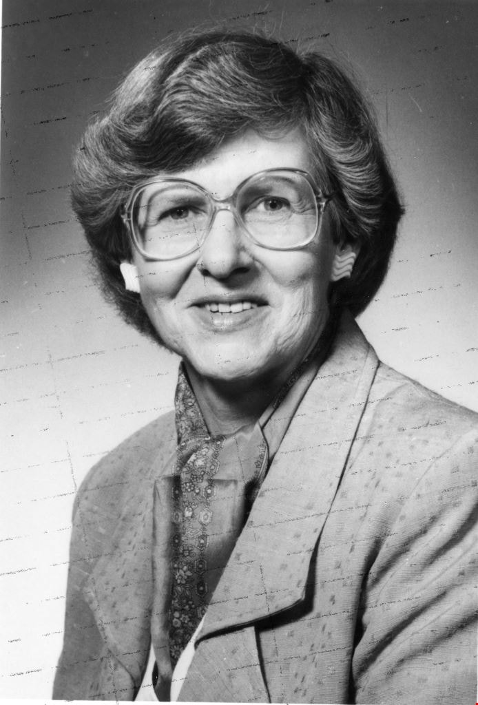
Election 1990 photographs
https://search.heritageburnaby.ca/link/archivedescription91556
- Repository
- City of Burnaby Archives
- Date
- 1990
- Collection/Fonds
- Doreen Lawson fonds
- Description Level
- File
- Physical Description
- 2 photographs : col. and b&w ; 11.5 x 16.5 cm and 10 x 15 cm
- Scope and Content
- File consists of photographs related to Doreen Lawson's 1990 election campaign. One photograph is a black and white portrait of Ms. Lawson and the second photograph depicts two municipal election signs posted in a resident's front yard.
- Repository
- City of Burnaby Archives
- Date
- 1990
- Collection/Fonds
- Doreen Lawson fonds
- Physical Description
- 2 photographs : col. and b&w ; 11.5 x 16.5 cm and 10 x 15 cm
- Description Level
- File
- Record No.
- 605-002
- Access Restriction
- No restrictions
- Reproduction Restriction
- No restrictions
- Accession Number
- 2003-30
- Scope and Content
- File consists of photographs related to Doreen Lawson's 1990 election campaign. One photograph is a black and white portrait of Ms. Lawson and the second photograph depicts two municipal election signs posted in a resident's front yard.
- Names
- Lawson, Doreen A.
- Media Type
- Photograph
- Notes
- Title based on contents of photographs
- Photographs separated from file MSS071-002
Images
6850 Hastings burnaby [sic]
https://search.heritageburnaby.ca/link/archivedescription94297
- Repository
- City of Burnaby Archives
- Date
- November 1993
- Collection/Fonds
- Grover, Elliott & Co. Ltd. fonds
- Description Level
- File
- Physical Description
- 26 photographs : col. negatives ; 35 mm
- Scope and Content
- Photographs of the exterior of a Liquidation World store and several houses along an unidentified residential street. The address 6850 Hastings Street no longer exists.
- Repository
- City of Burnaby Archives
- Date
- November 1993
- Collection/Fonds
- Grover, Elliott & Co. Ltd. fonds
- Physical Description
- 26 photographs : col. negatives ; 35 mm
- Description Level
- File
- Record No.
- 622-082
- Access Restriction
- No restrictions
- Reproduction Restriction
- No restrictions
- Accession Number
- 2017-39
- Scope and Content
- Photographs of the exterior of a Liquidation World store and several houses along an unidentified residential street. The address 6850 Hastings Street no longer exists.
- Media Type
- Photograph
- Notes
- Transcribed title
- Title transcribed from envelope photographs were originally housed in
- File no. 93-468-B
- Photographer identified as "L.D."
- Geographic Access
- Hastings Street
- Historic Neighbourhood
- Lochdale (Historic Neighbourhood)
- Planning Study Area
- Westridge Area
6979 Hastings St / 6941 Hastings St / 6951 Hastings St / 6939 Hastings St
https://search.heritageburnaby.ca/link/archivedescription94169
- Repository
- City of Burnaby Archives
- Date
- July 30, 1993
- Collection/Fonds
- Grover, Elliott & Co. Ltd. fonds
- Description Level
- File
- Physical Description
- 141 photographs : col. negatives ; 35 mm
- Scope and Content
- Photographs of various residential and commercial properties located throughout Burnaby. Stores visible in the photographs include Cafe Classico at 4293 Hastings Street, Firestone at 6941 Hastings Street, Coast Automatic Transmissions at 4700 Imperial Street, and Bill's Tune Up at 6979 Hastings St…
- Repository
- City of Burnaby Archives
- Date
- July 30, 1993
- Collection/Fonds
- Grover, Elliott & Co. Ltd. fonds
- Physical Description
- 141 photographs : col. negatives ; 35 mm
- Description Level
- File
- Record No.
- 622-077
- Access Restriction
- No restrictions
- Reproduction Restriction
- No restrictions
- Accession Number
- 2017-39
- Scope and Content
- Photographs of various residential and commercial properties located throughout Burnaby. Stores visible in the photographs include Cafe Classico at 4293 Hastings Street, Firestone at 6941 Hastings Street, Coast Automatic Transmissions at 4700 Imperial Street, and Bill's Tune Up at 6979 Hastings Street.
- Media Type
- Photograph
- Notes
- Transcribed title
- File nos. 93-309-B, 93-310-B, 39-308-B, and 93-307-B
- Title and file numbers transcribed from manilla envelope photographs were originally housed in.
- Date transcribed from manilla envelope photographs were originally housed in.
- File no. 93-309-B is titled "6979 Hastings St."
- File no. 93-310-B is titled "6941 Hastings St."
- File no. 93-308-B is titled "6951 Hastings St."
- File no. 93-307-B is titled "3939 Hastings St."
- It is not known which photographs were originally contained in each file.
- Photographer identified as "H., Karl"
- Geographic Access
- Hastings Street
- Imperial Street
Oral history interview with Annie Chamberlain and William Charles Parker
https://search.heritageburnaby.ca/link/museumdescription9835
- Repository
- Burnaby Village Museum
- Date
- June 6, 1991
- Collection/Fonds
- Burnaby Village Museum fonds
- Description Level
- File
- Physical Description
- 1 folder of textual records
- Scope and Content
- File consists of notes and transcripts of an oral history interview with relatives of the Jesse and Martha Love family. Interviews were conducted to gather historical information regarding the Love family farmhouse which was moved from Cumberland Street to the Burnaby Village Museum in November 198…
- Repository
- Burnaby Village Museum
- Collection/Fonds
- Burnaby Village Museum fonds
- Series
- Jesse Love farmhouse series
- Description Level
- File
- Physical Description
- 1 folder of textual records
- Material Details
- Interviewer: Colin Stevens Interviewee: Annie Chamberlain and William Charles Parker
- Scope and Content
- File consists of notes and transcripts of an oral history interview with relatives of the Jesse and Martha Love family. Interviews were conducted to gather historical information regarding the Love family farmhouse which was moved from Cumberland Street to the Burnaby Village Museum in November 1988. Records include: seven pages of typewritten notes taken by Susan Green along with notes by Colin Stevens during an oral history interview with Annie Chamberlain and William Charles Parker (Burnaby Village Museum. June 6, 1991).
- Creator
- Stevens, Colin
- Accession Code
- BV018.41.46
- Access Restriction
- No restrictions
- Reproduction Restriction
- May be restricted by third party rights
- Date
- June 6, 1991
- Media Type
- Textual Record
- Notes
- Title based on content of file
SFU Campus/Residential
https://search.heritageburnaby.ca/link/archivedescription93881
- Repository
- City of Burnaby Archives
- Date
- February 1993
- Collection/Fonds
- Grover, Elliott & Co. Ltd. fonds
- Description Level
- File
- Physical Description
- 24 photographs : col. negatives ; 35 mm
- Scope and Content
- Photographs of the exteriors of four Simon Fraser Univeristy (SFU) campus residences.
- Repository
- City of Burnaby Archives
- Date
- February 1993
- Collection/Fonds
- Grover, Elliott & Co. Ltd. fonds
- Physical Description
- 24 photographs : col. negatives ; 35 mm
- Description Level
- File
- Record No.
- 622-064
- Access Restriction
- No restrictions
- Reproduction Restriction
- No restrictions
- Accession Number
- 2017-39
- Scope and Content
- Photographs of the exteriors of four Simon Fraser Univeristy (SFU) campus residences.
- Names
- Simon Fraser University
- Media Type
- Photograph
- Notes
- Transcribed title
- Title transcribed from envelope photographs were originally housed in
- File no. 93-050-B
- Geographic Access
- Burnaby Mountain Conservation Area
- Planning Study Area
- Burnaby Mountain Area
SFU Rez, Burnaby
https://search.heritageburnaby.ca/link/archivedescription94328
- Repository
- City of Burnaby Archives
- Date
- February 1995
- Collection/Fonds
- Grover, Elliott & Co. Ltd. fonds
- Description Level
- File
- Physical Description
- 24 photographs : col. negatives ; 35 mm
- Scope and Content
- Photographs of the exteriors of Simon Fraser University campus residences, including Shell House, Hamilton Hall, and Townhouses.
- Repository
- City of Burnaby Archives
- Date
- February 1995
- Collection/Fonds
- Grover, Elliott & Co. Ltd. fonds
- Physical Description
- 24 photographs : col. negatives ; 35 mm
- Description Level
- File
- Record No.
- 622-113
- Access Restriction
- No restrictions
- Reproduction Restriction
- No restrictions
- Accession Number
- 2017-39
- Scope and Content
- Photographs of the exteriors of Simon Fraser University campus residences, including Shell House, Hamilton Hall, and Townhouses.
- Names
- Simon Fraser University
- Media Type
- Photograph
- Notes
- Transcribed title
- Title transcribed from envelope photographs were originally housed in
- File no. 95-010-B
- Photographer identified as "J.C."
- Geographic Access
- University Drive
- Street Address
- 8888 University Drive
- Planning Study Area
- Burnaby Mountain Area
#221-3823 Henning Dr, Burnaby
https://search.heritageburnaby.ca/link/archivedescription94353
- Repository
- City of Burnaby Archives
- Date
- 1998
- Collection/Fonds
- Grover, Elliott & Co. Ltd. fonds
- Description Level
- File
- Physical Description
- 10 photographs : col. negatives ; 35 mm
- Scope and Content
- Photographs of the exterior of a two-storey commercial building located at 3823 Henning Drive.
- Repository
- City of Burnaby Archives
- Date
- 1998
- Collection/Fonds
- Grover, Elliott & Co. Ltd. fonds
- Physical Description
- 10 photographs : col. negatives ; 35 mm
- Description Level
- File
- Record No.
- 622-138
- Access Restriction
- No restrictions
- Reproduction Restriction
- No restrictions
- Accession Number
- 2017-39
- Scope and Content
- Photographs of the exterior of a two-storey commercial building located at 3823 Henning Drive.
- Subjects
- Buildings - Residential
- Media Type
- Photograph
- Notes
- Transcribed title
- Title transcribed from envelope photographs were originally housed in
- File no. 98-247-B
- Geographic Access
- Henning Drive
- Street Address
- 3823 Henning Drive
- Historic Neighbourhood
- Broadview (Historic Neighbourhood)
- Planning Study Area
- West Central Valley Area
1850 Rosser Ave Burnaby
https://search.heritageburnaby.ca/link/archivedescription93890
- Repository
- City of Burnaby Archives
- Date
- June 1993
- Collection/Fonds
- Grover, Elliott & Co. Ltd. fonds
- Description Level
- File
- Physical Description
- 35 photographs : col. negatives ; 35 mm
- Scope and Content
- Photographs of an 18-storey residential tower located at 1850 Rosser Avenue.
- Repository
- City of Burnaby Archives
- Date
- June 1993
- Collection/Fonds
- Grover, Elliott & Co. Ltd. fonds
- Physical Description
- 35 photographs : col. negatives ; 35 mm
- Description Level
- File
- Record No.
- 622-073
- Access Restriction
- No restrictions
- Reproduction Restriction
- No restrictions
- Accession Number
- 2017-39
- Scope and Content
- Photographs of an 18-storey residential tower located at 1850 Rosser Avenue.
- Subjects
- Buildings - Residential
- Media Type
- Photograph
- Notes
- Transcribed title
- Title transcribed from envelope photographs were originally housed in
- File no. 93-268-B
- Note in blue pen on photograph envelope reads: "Rideau Manor".
- Photographer identified as "D.E."
- Geographic Access
- Rosser Avenue
- Street Address
- 1850 Rosser Avenue
- Historic Neighbourhood
- Vancouver Heights (Historic Neighbourhood)
- Planning Study Area
- Willingdon Heights Area