More like 'Ceperley touring car'
Narrow Results By
Subject
- Advertising Medium - Signs and Signboards 5
- Agricultural Tools and Equipment - Gardening Equipment 1
- Agriculture - Farms 1
- Animals - Dogs 1
- Arts - Paintings 2
- Arts - Sculptures 3
- Buildings - Agricultural - Barns 1
- Buildings - Civic 1
- Buildings - Civic - Art Galleries 7
- Buildings - Civic - City Halls 1
- Buildings - Civic - Community Centres 1
- Buildings - Civic - Hospitals 9

Venables Street
https://search.heritageburnaby.ca/link/archivedescription52845
- Repository
- City of Burnaby Archives
- Date
- 1981
- Collection/Fonds
- Harold H. Johnston fonds
- Description Level
- Item
- Physical Description
- 1 photograph (jpeg) : b&w
- Scope and Content
- Photograph of a woman standing next to two children on a tricycle on Venables Street. A man is on the far right standing next to a parked car. Three of the people in the photograph are identified by first name only as Sharron, Andrea and Frank. The photograph was most likely taken near the Johnston…
- Repository
- City of Burnaby Archives
- Date
- 1981
- Collection/Fonds
- Harold H. Johnston fonds
- Physical Description
- 1 photograph (jpeg) : b&w
- Description Level
- Item
- Record No.
- 483-102
- Access Restriction
- No restrictions
- Reproduction Restriction
- No reproduction permitted
- Accession Number
- 2008-08
- Scope and Content
- Photograph of a woman standing next to two children on a tricycle on Venables Street. A man is on the far right standing next to a parked car. Three of the people in the photograph are identified by first name only as Sharron, Andrea and Frank. The photograph was most likely taken near the Johnston family home at 4447 Venables Street.
- Subjects
- Transportation - Automobiles
- Transportation - Bicycles
- Buildings - Residential - Houses
- Geographic Features - Roads
- Media Type
- Photograph
- Photographer
- Johnston, Harold H.
- Notes
- Title based on contents of photograph
- Geographic Access
- Venables Street
- Historic Neighbourhood
- Vancouver Heights (Historic Neighbourhood)
- Planning Study Area
- Willingdon Heights Area
Images

5507 to 5555 Inman Ave
https://search.heritageburnaby.ca/link/archivedescription93747
- Repository
- City of Burnaby Archives
- Date
- 1989
- Collection/Fonds
- Grover, Elliott & Co. Ltd. fonds
- Description Level
- File
- Physical Description
- 19 photographs : col. negatives ; 35 mm
- Scope and Content
- Photographs of the properties located at 5507 to 5555 Inman Avenue - addresses that no longer exist. Buildings on the properties are single-storey houses.
- Repository
- City of Burnaby Archives
- Date
- 1989
- Collection/Fonds
- Grover, Elliott & Co. Ltd. fonds
- Physical Description
- 19 photographs : col. negatives ; 35 mm
- Description Level
- File
- Record No.
- 622-032
- Access Restriction
- No restrictions
- Reproduction Restriction
- No restrictions
- Accession Number
- 2017-39
- Scope and Content
- Photographs of the properties located at 5507 to 5555 Inman Avenue - addresses that no longer exist. Buildings on the properties are single-storey houses.
- Media Type
- Photograph
- Notes
- Transcribed title
- Title transcribed from print envelope photographs were originally housed in
- File no. 89-519-B
- Geographic Access
- Inman Avenue
- Historic Neighbourhood
- Central Park (Historic Neighbourhood)
- Planning Study Area
- Garden Village Area
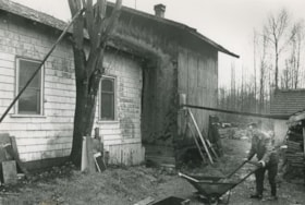
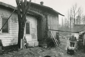
John Booth outside a rented Burnaby house
https://search.heritageburnaby.ca/link/archivedescription59059
- Repository
- City of Burnaby Archives
- Date
- ca.1983
- Collection/Fonds
- Columbian Newspaper collection
- Description Level
- Item
- Physical Description
- 1 photograph : b&w ; 20.5 x 25.5 cm
- Scope and Content
- Photograph of a man, identified as John Booth, pushing a wheelbarrow outside of a rented house in Burnaby. The home is in disrepair.
- Repository
- City of Burnaby Archives
- Date
- ca.1983
- Collection/Fonds
- Columbian Newspaper collection
- Physical Description
- 1 photograph : b&w ; 20.5 x 25.5 cm
- Description Level
- Item
- Record No.
- 480-1465
- Access Restriction
- No restrictions
- Reproduction Restriction
- Reproduce for fair dealing purposes only
- Accession Number
- 2009-01
- Scope and Content
- Photograph of a man, identified as John Booth, pushing a wheelbarrow outside of a rented house in Burnaby. The home is in disrepair.
- Media Type
- Photograph
- Notes
- Title based on contents of photograph
- Note on recto reads: "John Booth / outside rented Burnaby house"
- Note on verso reads: "100% / A-1 / Booth"
Images
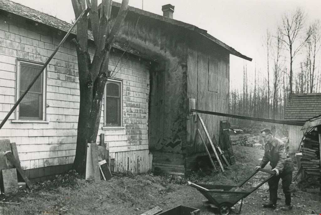
Man with a wheelbarrow outside a house
https://search.heritageburnaby.ca/link/archivedescription59180
- Repository
- City of Burnaby Archives
- Date
- ca.1982
- Collection/Fonds
- Columbian Newspaper collection
- Description Level
- Item
- Physical Description
- 1 photograph : b&w ; 20.5 x 25.5 cm
- Scope and Content
- Photograph of a man, identified as John Booth, pushing a wheelbarrow outside of a rented house in Burnaby. The home is in disrepair.
- Repository
- City of Burnaby Archives
- Date
- ca.1982
- Collection/Fonds
- Columbian Newspaper collection
- Physical Description
- 1 photograph : b&w ; 20.5 x 25.5 cm
- Description Level
- Item
- Record No.
- 480-1503
- Access Restriction
- No restrictions
- Reproduction Restriction
- Reproduce for fair dealing purposes only
- Accession Number
- 2009-01
- Scope and Content
- Photograph of a man, identified as John Booth, pushing a wheelbarrow outside of a rented house in Burnaby. The home is in disrepair.
- Media Type
- Photograph
- Photographer
- King, Basil
- Notes
- Title based on contents of photograph
- Photographer's stamp on verso
- Note on verso reads: "PMT 83% / page 1 / Burnaby / Today"
- John Booth identified in 480-1465
Images

7973-7993 Enterprise St
https://search.heritageburnaby.ca/link/archivedescription93718
- Repository
- City of Burnaby Archives
- Date
- 1987
- Collection/Fonds
- Grover, Elliott & Co. Ltd. fonds
- Description Level
- File
- Physical Description
- 14 photographs : col. ; 10 cm x 15 cm
- Scope and Content
- Photographs of the exterior of the commercial complex located at 7973 and 7993 Enterprise Street. Businesses visible in the photographs include: Universal, Philips, Canpar, Boss Cartage, and Hercules Forwarding Ltd.
- Repository
- City of Burnaby Archives
- Date
- 1987
- Collection/Fonds
- Grover, Elliott & Co. Ltd. fonds
- Physical Description
- 14 photographs : col. ; 10 cm x 15 cm
- Description Level
- File
- Record No.
- 622-007
- Access Restriction
- No restrictions
- Reproduction Restriction
- No restrictions
- Accession Number
- 2017-39
- Scope and Content
- Photographs of the exterior of the commercial complex located at 7973 and 7993 Enterprise Street. Businesses visible in the photographs include: Universal, Philips, Canpar, Boss Cartage, and Hercules Forwarding Ltd.
- Media Type
- Photograph
- Notes
- Transcribed title
- Title transcribed from original print envelope
- File no. 87-485-B
- Geographic Access
- Enterprise Street
- Street Address
- 7973 Enterprise Street
- 7993 Enterprise Street
- Planning Study Area
- Lake City Area
5608 to 5628 Imperial Street
https://search.heritageburnaby.ca/link/archivedescription93730
- Repository
- City of Burnaby Archives
- Date
- 1989
- Collection/Fonds
- Grover, Elliott & Co. Ltd. fonds
- Description Level
- File
- Physical Description
- 16 photographs : col. negatives ; 35 mm
- Scope and Content
- Photographs of the commerical properties located between 5608 and 5628 Imperial Street and the intersection at Imperial Street and MacPherson Avenue. Businesses visible in the photographs include Galaxie Collision, Minit-tune, and Canadian Cash and Carry Tire Centre.
- Repository
- City of Burnaby Archives
- Date
- 1989
- Collection/Fonds
- Grover, Elliott & Co. Ltd. fonds
- Physical Description
- 16 photographs : col. negatives ; 35 mm
- Description Level
- File
- Record No.
- 622-018
- Access Restriction
- No restrictions
- Reproduction Restriction
- No restrictions
- Accession Number
- 2017-39
- Scope and Content
- Photographs of the commerical properties located between 5608 and 5628 Imperial Street and the intersection at Imperial Street and MacPherson Avenue. Businesses visible in the photographs include Galaxie Collision, Minit-tune, and Canadian Cash and Carry Tire Centre.
- Media Type
- Photograph
- Photographer
- Young, J.
- Notes
- Transcribed title
- Title transcribed from original print envelope
- Geographic Access
- Imperial Street
- MacPherson Avenue
- Street Address
- 5608 Imperial Street
- 5628 Imperial Street
- Historic Neighbourhood
- Central Park (Historic Neighbourhood)
- Planning Study Area
- Windsor Area
7818 6th Street
https://search.heritageburnaby.ca/link/archivedescription93731
- Repository
- City of Burnaby Archives
- Date
- 1989
- Collection/Fonds
- Grover, Elliott & Co. Ltd. fonds
- Description Level
- File
- Physical Description
- 26 photographs : col. negatives ; 35 mm
- Scope and Content
- Photographs of the exterior of a Benjamin Moore Paints store and surrounding area. The store is located on a corner opposite Microtel and outside the store, a sign for the Skytrain Operations and Maintenance Centre is visible.
- Repository
- City of Burnaby Archives
- Date
- 1989
- Collection/Fonds
- Grover, Elliott & Co. Ltd. fonds
- Physical Description
- 26 photographs : col. negatives ; 35 mm
- Description Level
- File
- Record No.
- 622-019
- Access Restriction
- No restrictions
- Reproduction Restriction
- No restrictions
- Accession Number
- 2017-39
- Scope and Content
- Photographs of the exterior of a Benjamin Moore Paints store and surrounding area. The store is located on a corner opposite Microtel and outside the store, a sign for the Skytrain Operations and Maintenance Centre is visible.
- Media Type
- Photograph
- Notes
- Transcribed title
- Title transcribed from original print envelope
- File no. 89v-004-O
- Property address could not be confirmed at time of description.
- Geographic Access
- 6th Street
- 12th Avenue
- Street Address
- 7818 6th Street
- Historic Neighbourhood
- East Burnaby (Historic Neighbourhood)
- Planning Study Area
- Second Street Area
![Baggraw Hall, [198-] thumbnail](/media/hpo/_Data/_BVM_Images/2020/2020_0005_0971_001.jpg?width=280)
Baggraw Hall
https://search.heritageburnaby.ca/link/museumdescription13848
- Repository
- Burnaby Village Museum
- Date
- [198-]
- Collection/Fonds
- Century Park Museum Association fonds
- Description Level
- Item
- Physical Description
- 1 photograph : col. slide ; 4 x 4 cm transparency film in slide mount 5 x 5 cm
- Scope and Content
- Photograph of Baggraw Hall, the ancestral home of the Burnaby family.
- Repository
- Burnaby Village Museum
- Collection/Fonds
- Century Park Museum Association fonds
- Description Level
- Item
- Physical Description
- 1 photograph : col. slide ; 4 x 4 cm transparency film in slide mount 5 x 5 cm
- Material Details
- "127 Slide" Kodak film
- Scope and Content
- Photograph of Baggraw Hall, the ancestral home of the Burnaby family.
- Names
- Burnaby, Robert
- Accession Code
- BV020.5.971
- Access Restriction
- No restrictions
- Reproduction Restriction
- No known restrictions
- Date
- [198-]
- Media Type
- Photograph
- Scan Resolution
- 2400
- Scan Date
- 22-Sep-2020
- Scale
- 100
- Notes
- Title based on contents of photograph
- Handwritten notes in blue ink frame of slide read: "BHS / BAGGRAW HALL / ROBERT BURNABY / ANCESTRAL HOME"
- Round sticker on slide with number "4"
Images
![Baggraw Hall, [198-] thumbnail](/media/hpo/_Data/_BVM_Images/2020/2020_0005_0971_001.jpg)
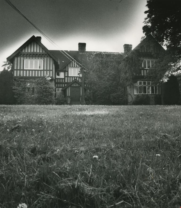
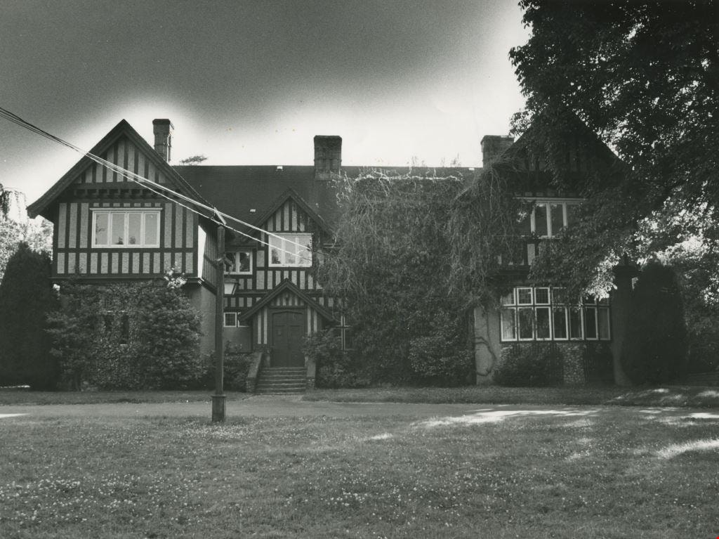
Hart House and front yard
https://search.heritageburnaby.ca/link/archivedescription36126
- Repository
- City of Burnaby Archives
- Date
- June 21, 1983
- Collection/Fonds
- Burnaby Historical Society fonds
- Description Level
- Item
- Physical Description
- 1 photograph : b&w ; 19 x 22 cm
- Scope and Content
- Photograph of the Hart House and front yard.
- Repository
- City of Burnaby Archives
- Date
- June 21, 1983
- Collection/Fonds
- Burnaby Historical Society fonds
- Subseries
- Columbian Newspaper subseries
- Physical Description
- 1 photograph : b&w ; 19 x 22 cm
- Description Level
- Item
- Record No.
- 222-049
- Access Restriction
- No restrictions
- Reproduction Restriction
- Reproduce for fair dealing purposes only
- Accession Number
- BHS1989-19
- Scope and Content
- Photograph of the Hart House and front yard.
- Media Type
- Photograph
- Photographer
- Braid, Tom
- Notes
- Title based on contents of photograph
- Geographic Access
- Deer Lake Avenue
- Street Address
- 6664 Deer Lake Avenue
- Historic Neighbourhood
- Burnaby Lake (Historic Neighbourhood)
- Planning Study Area
- Morley-Buckingham Area
Images

Hart House and front yard
https://search.heritageburnaby.ca/link/archivedescription36127
- Repository
- City of Burnaby Archives
- Date
- June 21, 1983
- Collection/Fonds
- Burnaby Historical Society fonds
- Description Level
- Item
- Physical Description
- 1 photograph : b&w ; 18 x 24 cm
- Scope and Content
- Photograph of the Hart House and front yard.
- Repository
- City of Burnaby Archives
- Date
- June 21, 1983
- Collection/Fonds
- Burnaby Historical Society fonds
- Subseries
- Columbian Newspaper subseries
- Physical Description
- 1 photograph : b&w ; 18 x 24 cm
- Description Level
- Item
- Record No.
- 222-050
- Access Restriction
- No restrictions
- Reproduction Restriction
- Reproduce for fair dealing purposes only
- Accession Number
- BHS1989-19
- Scope and Content
- Photograph of the Hart House and front yard.
- Media Type
- Photograph
- Photographer
- Braid, Tom
- Notes
- Title based on contents of photograph
- Geographic Access
- Deer Lake Avenue
- Street Address
- 6664 Deer Lake Avenue
- Historic Neighbourhood
- Burnaby Lake (Historic Neighbourhood)
- Planning Study Area
- Morley-Buckingham Area
Images
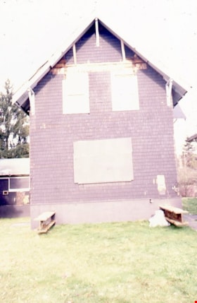
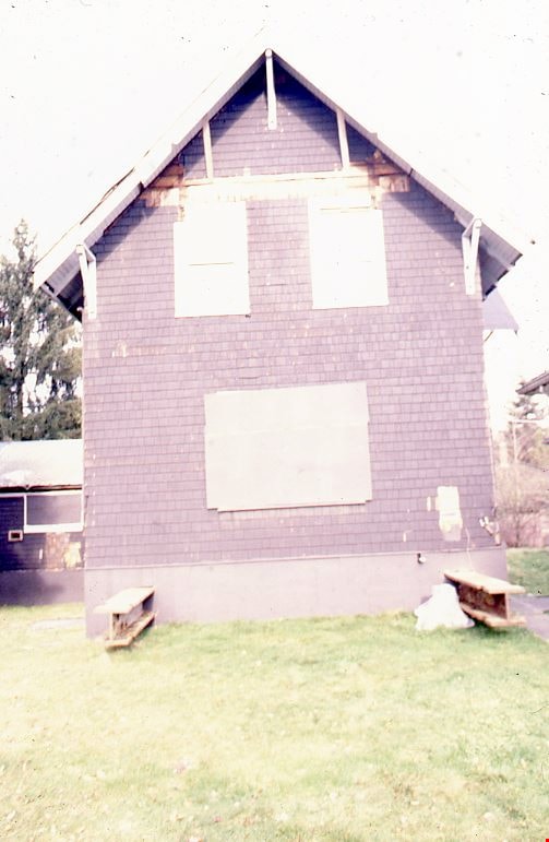
Love farmhouse at Burnaby Village Museum
https://search.heritageburnaby.ca/link/museumdescription10265
- Repository
- Burnaby Village Museum
- Date
- Aug. 28, 1988
- Collection/Fonds
- Burnaby Village Museum fonds
- Description Level
- Item
- Physical Description
- 1 photograph : col. slide ; 35 mm
- Scope and Content
- Photograph of the Love farmhouse boarded up and installed temporarily on site at Burnaby Village Museum. Both the roof and kitchen have been reattached. Large steel I-beams can be seen protruding from the bottom.
- Repository
- Burnaby Village Museum
- Collection/Fonds
- Burnaby Village Museum fonds
- Series
- Jesse Love farmhouse series
- Description Level
- Item
- Physical Description
- 1 photograph : col. slide ; 35 mm
- Scope and Content
- Photograph of the Love farmhouse boarded up and installed temporarily on site at Burnaby Village Museum. Both the roof and kitchen have been reattached. Large steel I-beams can be seen protruding from the bottom.
- Names
- Burnaby Village Museum
- Accession Code
- BV018.41.211
- Access Restriction
- No restrictions
- Reproduction Restriction
- No known restrictions
- Date
- Aug. 28, 1988
- Media Type
- Photograph
- Scan Resolution
- 600
- Scan Date
- 24-Feb-19
- Scale
- 96
- Photographer
- Wolf, Jim
- Notes
- Title based on contents of photograph
Images

Naud house
https://search.heritageburnaby.ca/link/archivedescription38295
- Repository
- City of Burnaby Archives
- Date
- 1985
- Collection/Fonds
- Burnaby Historical Society fonds
- Description Level
- Item
- Physical Description
- 1 photograph : b&w ; 12.5 x 17.5 cm
- Scope and Content
- Photograph of the Naud house, at 4737 Victory Street. This home was built by Onzieme Naud and is now a protected heritage site in Burnaby.
- Repository
- City of Burnaby Archives
- Date
- 1985
- Collection/Fonds
- Burnaby Historical Society fonds
- Subseries
- Photographs subseries
- Physical Description
- 1 photograph : b&w ; 12.5 x 17.5 cm
- Description Level
- Item
- Record No.
- 398-002
- Access Restriction
- No restrictions
- Reproduction Restriction
- Reproduce for fair dealing purposes only
- Accession Number
- BHS2007-04
- Scope and Content
- Photograph of the Naud house, at 4737 Victory Street. This home was built by Onzieme Naud and is now a protected heritage site in Burnaby.
- Media Type
- Photograph
- Notes
- Title based on contents of photograph
- Geographic Access
- Victory Street
- Street Address
- 4737 Victory Street
- Historic Neighbourhood
- Alta-Vista (Historic Neighbourhood)
- Planning Study Area
- Sussex-Nelson Area
Images

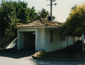
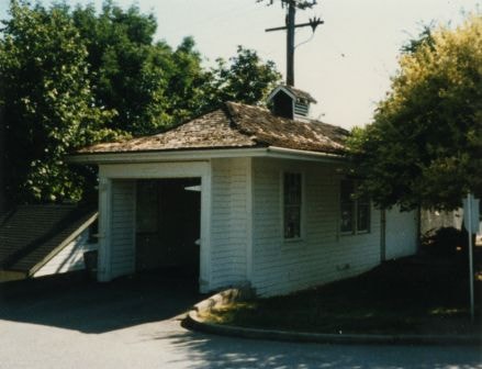
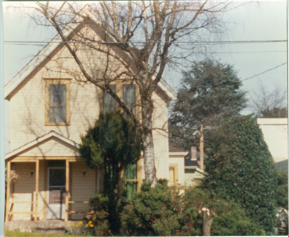
Oakalla Warden's House
https://search.heritageburnaby.ca/link/archivedescription34854
- Repository
- City of Burnaby Archives
- Date
- 1985
- Collection/Fonds
- Burnaby Historical Society fonds
- Description Level
- Item
- Physical Description
- 1 photograph : col. ; 8.8 x 11.3 cm
- Scope and Content
- Photograph of the Warden's house and garage at Oakalla Prison Farm, Royal Oak Road.
- Repository
- City of Burnaby Archives
- Date
- 1985
- Collection/Fonds
- Burnaby Historical Society fonds
- Subseries
- Evelyn Salisbury subseries
- Physical Description
- 1 photograph : col. ; 8.8 x 11.3 cm
- Description Level
- Item
- Record No.
- 145-002
- Access Restriction
- No restrictions
- Reproduction Restriction
- Reproduce for fair dealing purposes only
- Accession Number
- BHS1985-15
- Scope and Content
- Photograph of the Warden's house and garage at Oakalla Prison Farm, Royal Oak Road.
- Names
- Oakalla Prison Farm
- Media Type
- Photograph
- Notes
- Title based on contents of photograph
- Geographic Access
- Oakmount Crescent
- Street Address
- 5220 Oakmount Crescent
- Historic Neighbourhood
- Burnaby Lake (Historic Neighbourhood)
- Planning Study Area
- Oakalla Area
Images

Overlynn house
https://search.heritageburnaby.ca/link/archivedescription38299
- Repository
- City of Burnaby Archives
- Date
- 1985
- Collection/Fonds
- Burnaby Historical Society fonds
- Description Level
- Item
- Physical Description
- 1 photograph : b&w ; 12.5 x 17.5 cm
- Scope and Content
- Photograph of the Overlynn house at 3755 McGill Street, North Burnaby. This home was built by Charles J. Peter in 1909 and is now a protected heritage site in Burnaby.
- Repository
- City of Burnaby Archives
- Date
- 1985
- Collection/Fonds
- Burnaby Historical Society fonds
- Subseries
- Photographs subseries
- Physical Description
- 1 photograph : b&w ; 12.5 x 17.5 cm
- Description Level
- Item
- Record No.
- 398-006
- Access Restriction
- No restrictions
- Reproduction Restriction
- Reproduce for fair dealing purposes only
- Accession Number
- BHS2007-04
- Scope and Content
- Photograph of the Overlynn house at 3755 McGill Street, North Burnaby. This home was built by Charles J. Peter in 1909 and is now a protected heritage site in Burnaby.
- Media Type
- Photograph
- Notes
- Title based on contents of photograph
- Geographic Access
- McGill Street
- Street Address
- 3755 McGill Street
- Historic Neighbourhood
- Vancouver Heights (Historic Neighbourhood)
- Planning Study Area
- Burnaby Heights Area
Images

![Woodthorpe, [198-] thumbnail](/media/hpo/_Data/_BVM_Images/2020/2020_0005_0972_001.jpg?width=280)
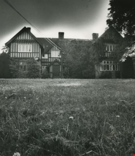
Woodthorpe
https://search.heritageburnaby.ca/link/museumdescription13849
- Repository
- Burnaby Village Museum
- Date
- [198-]
- Collection/Fonds
- Century Park Museum Association fonds
- Description Level
- Item
- Physical Description
- 1 photograph : col. slide ; 4 x 4 cm transparency film in slide mount 5 x 5 cm
- Scope and Content
- Photograph of Woodthorpe house, Leicestershire. This was Robert Burnaby's birthplace and family home. He was born at Woodthorpe in 1828 and died at Woodthorpe in 1878.
- Repository
- Burnaby Village Museum
- Collection/Fonds
- Century Park Museum Association fonds
- Description Level
- Item
- Physical Description
- 1 photograph : col. slide ; 4 x 4 cm transparency film in slide mount 5 x 5 cm
- Material Details
- "127 Slide" Kodak film
- Scope and Content
- Photograph of Woodthorpe house, Leicestershire. This was Robert Burnaby's birthplace and family home. He was born at Woodthorpe in 1828 and died at Woodthorpe in 1878.
- Names
- Burnaby, Robert
- Accession Code
- BV020.5.972
- Access Restriction
- No restrictions
- Reproduction Restriction
- No known restrictions
- Date
- [198-]
- Media Type
- Photograph
- Scan Resolution
- 2400
- Scan Date
- 22-Sep-2020
- Scale
- 100
- Notes
- Title based on contents of photograph
- Handwritten notes in blue in frame of slide read: "BHS / BAGGRAW HALL / ROBERT BURNABY / ANCESTRAL HOME"
- Round sticker on slide with number "4"
Images
![Woodthorpe, [198-] thumbnail](/media/hpo/_Data/_BVM_Images/2020/2020_0005_0972_001.jpg)

309 Pine Street
https://search.heritageburnaby.ca/link/museumdescription2814
- Repository
- Burnaby Village Museum
- Date
- 1987
- Collection/Fonds
- Hawkshaw family fonds
- Description Level
- Item
- Physical Description
- 1 photograph : col. ; 10 x 12.5 cm
- Scope and Content
- Photograph of 309 Pine Street, New Westminster. This was John and Mabel Hawkshaw’s first home in 1910.
- Repository
- Burnaby Village Museum
- Collection/Fonds
- Hawkshaw family fonds
- Description Level
- Item
- Physical Description
- 1 photograph : col. ; 10 x 12.5 cm
- Scope and Content
- Photograph of 309 Pine Street, New Westminster. This was John and Mabel Hawkshaw’s first home in 1910.
- Subjects
- Buildings - Residential - Houses
- Geographic Access
- New Westminster
- Accession Code
- BV996.6.288
- Access Restriction
- No restrictions
- Reproduction Restriction
- No known restrictions
- Date
- 1987
- Media Type
- Photograph
- Scan Resolution
- 600
- Scan Date
- 2024-05-07
- Notes
- Title based on contents of photograph
- Note on verso of photograph reads: "1987 / 309 Pine street / New Westminster / John + Mabel Hawkshaw's / 1st home / 1910"
Images

1982 - Moving the Roberts House
https://search.heritageburnaby.ca/link/archivedescription91880
- Repository
- City of Burnaby Archives
- Date
- 1982
- Collection/Fonds
- Small family fonds
- Description Level
- Item
- Physical Description
- 1 photograph : col. copy print ; 10 cm x 15 cm
- Scope and Content
- Photograph of the land being cleared at 5496 Dominion Street in order to create a path to move the Roberts' house onto the property. Included in the clearing are the stumps of two apples trees, a poplar tree, and a maple tree. The debris from the site was burned and smoke can seen rising from a s…
- Repository
- City of Burnaby Archives
- Date
- 1982
- Collection/Fonds
- Small family fonds
- Physical Description
- 1 photograph : col. copy print ; 10 cm x 15 cm
- Description Level
- Item
- Record No.
- 620-061
- Access Restriction
- No restrictions
- Reproduction Restriction
- No reproduction permitted
- Accession Number
- 2017-01
- Scope and Content
- Photograph of the land being cleared at 5496 Dominion Street in order to create a path to move the Roberts' house onto the property. Included in the clearing are the stumps of two apples trees, a poplar tree, and a maple tree. The debris from the site was burned and smoke can seen rising from a small pile of brush on the right.
- Media Type
- Photograph
- Notes
- Transcribed title
- Title transcribed from donor's notes
- Note in blue ink on verso of photograph reads: "p.3"
- Note in pencil on verso of photograph reads: "2"
- Street Address
- 5496 Dominion Street
- Historic Neighbourhood
- Burnaby Lake (Historic Neighbourhood)
- Planning Study Area
- Ardingley-Sprott Area
Images


1982 - Moving the Roberts House
https://search.heritageburnaby.ca/link/archivedescription91884
- Repository
- City of Burnaby Archives
- Date
- 1982
- Collection/Fonds
- Small family fonds
- Description Level
- Item
- Physical Description
- 1 photograph : col. ; 10 cm x 15 cm
- Scope and Content
- Photograph of the Roberts' house being moved from 5538 Dominion Street to 5496 Dominion Street. Wheels were attached to both ends of the iron beams supporting the raised house and one set of wheels was attached to a swivel on a flatbed truck to facilitate the move. The furnishings and appliances …
- Repository
- City of Burnaby Archives
- Date
- 1982
- Collection/Fonds
- Small family fonds
- Physical Description
- 1 photograph : col. ; 10 cm x 15 cm
- Description Level
- Item
- Record No.
- 620-065
- Access Restriction
- No restrictions
- Reproduction Restriction
- No reproduction permitted
- Accession Number
- 2017-01
- Scope and Content
- Photograph of the Roberts' house being moved from 5538 Dominion Street to 5496 Dominion Street. Wheels were attached to both ends of the iron beams supporting the raised house and one set of wheels was attached to a swivel on a flatbed truck to facilitate the move. The furnishings and appliances were left inside the house during the move.
- Media Type
- Photograph
- Notes
- Transcribed title
- Title transcribed from donor's notes
- Note in blue ink on verso of photograph reads: "P7"
- Note in black ink on verso of photograph reads: "7"
- Note in pencil on verso of photograph reads: "6"
- Street Address
- 5538 Dominion Street
- 5496 Dominion Street
- Historic Neighbourhood
- Burnaby Lake (Historic Neighbourhood)
- Planning Study Area
- Ardingley-Sprott Area
Images


1982 - Moving the Roberts House
https://search.heritageburnaby.ca/link/archivedescription91885
- Repository
- City of Burnaby Archives
- Date
- September 1982
- Collection/Fonds
- Small family fonds
- Description Level
- Item
- Physical Description
- 1 photograph : col. ; 10 cm x 15 cm
- Scope and Content
- Photograph of the Roberts' house being moved from 5538 Dominion Street to 5496 Dominion Street. Wheels were attached to both ends of the iron beams supporting the raised house and one set wheels was attached to a swivel on a flatbed truck to facilitate the move. The house was turned 90 degrees so…
- Repository
- City of Burnaby Archives
- Date
- September 1982
- Collection/Fonds
- Small family fonds
- Physical Description
- 1 photograph : col. ; 10 cm x 15 cm
- Description Level
- Item
- Record No.
- 620-066
- Access Restriction
- No restrictions
- Reproduction Restriction
- No reproduction permitted
- Accession Number
- 2017-01
- Scope and Content
- Photograph of the Roberts' house being moved from 5538 Dominion Street to 5496 Dominion Street. Wheels were attached to both ends of the iron beams supporting the raised house and one set wheels was attached to a swivel on a flatbed truck to facilitate the move. The house was turned 90 degrees so that it faced Dominion Street.
- Media Type
- Photograph
- Notes
- Transcribed title
- Title transcribed from donor's notes
- Note in blue ink on verso of photograph reads: "P.8"
- Note in black ink on verso of photograph reads: "8"
- Note in pencil on verso of photograph reads: "7"
- Note in black ink on verso of photograph reads: "Moving and Turning 90 [degrees] / Sept. 82"
- Street Address
- 5538 Dominion Street
- 5496 Dominion Street
- Historic Neighbourhood
- Burnaby Lake (Historic Neighbourhood)
- Planning Study Area
- Ardingley-Sprott Area
Images


1982 - Moving the Roberts House
https://search.heritageburnaby.ca/link/archivedescription91886
- Repository
- City of Burnaby Archives
- Date
- 1982
- Collection/Fonds
- Small family fonds
- Description Level
- Item
- Physical Description
- 1 photograph : col. ; 10 cm x 15 cm
- Scope and Content
- Photograph of the Roberts' house nearly in its new position after being moved from 5538 Dominion Street to 5496 Dominion Street. The move took nearly two full days to complete.
- Repository
- City of Burnaby Archives
- Date
- 1982
- Collection/Fonds
- Small family fonds
- Physical Description
- 1 photograph : col. ; 10 cm x 15 cm
- Description Level
- Item
- Record No.
- 620-067
- Access Restriction
- No restrictions
- Reproduction Restriction
- No reproduction permitted
- Accession Number
- 2017-01
- Scope and Content
- Photograph of the Roberts' house nearly in its new position after being moved from 5538 Dominion Street to 5496 Dominion Street. The move took nearly two full days to complete.
- Media Type
- Photograph
- Notes
- Transcribed title
- Title transcribed from donor's notes
- Note in blue ink on verso of photograph reads: "P9"
- Note in black ink on verso of photograph reads: "25"
- Note in pencil on verso of photograph reads: "8"
- Street Address
- 5538 Dominion Street
- 5496 Dominion Street
- Historic Neighbourhood
- Burnaby Lake (Historic Neighbourhood)
- Planning Study Area
- Ardingley-Sprott Area
Images
