More like 'Mary Warren and Bill Anthony'
Narrow Results By
Decade
- 2020s
- 2010s 118
- 2000s 662
- 1990s 641
- 1980s
- 1970s 946
- 1960s 378
- 1950s 544
- 1940s 596
- 1930s 608
- 1920s 650
- 1910s 604
- 1900s 270
- 1890s 36
- 1880s 70
- 1870s 5
- 1860s 3
- 1850s 1
- 1840s 1
- 1830s 1
- 1820s 1
- 1810s 1
- 1800s 1
- 1790s 1
- 1780s 1
- 1770s 1
- 1760s 1
- 1750s 1
- 1740s 1
- 1730s 1
- 1720s 1
- 1710s 1
- 1700s 1
- 1690s 1
- 1680s 1
- 1670s 1
- 1660s 1
- 1650s 1
- 1640s 1
- 1630s 1
- 1620s 1
- 1610s 1
- 1600s 1
6088 Cassie Avenue
https://search.heritageburnaby.ca/link/archivedescription93717
- Repository
- City of Burnaby Archives
- Date
- 1987
- Collection/Fonds
- Grover, Elliott & Co. Ltd. fonds
- Description Level
- File
- Physical Description
- 14 photographs : col. negatives ; 35 mm + 5 photographs : col. ; 10 cm x 15 cm
- Scope and Content
- Photographs of the private residence and garden located at 6088 Cassie Avenue - an address that no longer exists.
- Repository
- City of Burnaby Archives
- Date
- 1987
- Collection/Fonds
- Grover, Elliott & Co. Ltd. fonds
- Physical Description
- 14 photographs : col. negatives ; 35 mm + 5 photographs : col. ; 10 cm x 15 cm
- Description Level
- File
- Record No.
- 622-006
- Access Restriction
- No restrictions
- Reproduction Restriction
- No restrictions
- Accession Number
- 2017-39
- Scope and Content
- Photographs of the private residence and garden located at 6088 Cassie Avenue - an address that no longer exists.
- Media Type
- Photograph
- Notes
- Transcribed title
- Title transcribed from original print envelope
- File no. 87-300-B
- Geographic Access
- Cassie Avenue
- Historic Neighbourhood
- Central Park (Historic Neighbourhood)
- Planning Study Area
- Maywood Area
Edmonds St + 18th Ave (SW of 16th Street)
https://search.heritageburnaby.ca/link/archivedescription93727
- Repository
- City of Burnaby Archives
- Date
- March 1989
- Collection/Fonds
- Grover, Elliott & Co. Ltd. fonds
- Description Level
- File
- Physical Description
- 14 photographs : col. negatives ; 35 mm
- Scope and Content
- Photographs of the intersections at Edmonds Street and 18th Avenue and Edmonds Street and 16th Avenue and an unidentified residential lane.
- Repository
- City of Burnaby Archives
- Date
- March 1989
- Collection/Fonds
- Grover, Elliott & Co. Ltd. fonds
- Physical Description
- 14 photographs : col. negatives ; 35 mm
- Description Level
- File
- Record No.
- 622-015
- Access Restriction
- No restrictions
- Reproduction Restriction
- No restrictions
- Accession Number
- 2017-39
- Scope and Content
- Photographs of the intersections at Edmonds Street and 18th Avenue and Edmonds Street and 16th Avenue and an unidentified residential lane.
- Media Type
- Photograph
- Notes
- Transcribed title
- Title transcribed from original print envelope
- Photographs 622-015-001 : 622-015-002 depict Edmonds Street and 16th Avenue, facing south
- Photographs 622-015-003 : 622-015-004 depict the view southwest along Edmonds Street
- Photographs 622-015-006 : 622-015-008 depict the view southeast along 16th Street
- Photographs 622-015-009 : 622-015-011 depict the view southwest along 18th Avenue
- Locations were identified using notes on verso of accompanying prints
- Geographic Access
- 18th Avenue
- Edmonds Street
- 16th Avenue
- Historic Neighbourhood
- Edmonds (Historic Neighbourhood)
- Planning Study Area
- Stride Avenue Area

Venables Street
https://search.heritageburnaby.ca/link/archivedescription52845
- Repository
- City of Burnaby Archives
- Date
- 1981
- Collection/Fonds
- Harold H. Johnston fonds
- Description Level
- Item
- Physical Description
- 1 photograph (jpeg) : b&w
- Scope and Content
- Photograph of a woman standing next to two children on a tricycle on Venables Street. A man is on the far right standing next to a parked car. Three of the people in the photograph are identified by first name only as Sharron, Andrea and Frank. The photograph was most likely taken near the Johnston…
- Repository
- City of Burnaby Archives
- Date
- 1981
- Collection/Fonds
- Harold H. Johnston fonds
- Physical Description
- 1 photograph (jpeg) : b&w
- Description Level
- Item
- Record No.
- 483-102
- Access Restriction
- No restrictions
- Reproduction Restriction
- No reproduction permitted
- Accession Number
- 2008-08
- Scope and Content
- Photograph of a woman standing next to two children on a tricycle on Venables Street. A man is on the far right standing next to a parked car. Three of the people in the photograph are identified by first name only as Sharron, Andrea and Frank. The photograph was most likely taken near the Johnston family home at 4447 Venables Street.
- Subjects
- Transportation - Automobiles
- Transportation - Bicycles
- Buildings - Residential - Houses
- Geographic Features - Roads
- Media Type
- Photograph
- Photographer
- Johnston, Harold H.
- Notes
- Title based on contents of photograph
- Geographic Access
- Venables Street
- Historic Neighbourhood
- Vancouver Heights (Historic Neighbourhood)
- Planning Study Area
- Willingdon Heights Area
Images

Oral history interview with Hipman "Jimmy" Chow and Donna Polos
https://search.heritageburnaby.ca/link/museumdescription19146
- Repository
- Burnaby Village Museum
- Date
- 29 Jun. 2022
- Collection/Fonds
- Hipman "Jimmy" Chow and Donna Polos fonds
- Description Level
- Item
- Physical Description
- 3 sound recordings (wav) (02:06:53 min) + 1 sound recording (mp3) (02:06:53 min)
- Scope and Content
- Item consists of an audio recording of an oral history interview with Jimmy Chow and Donna Polos conducted by Denise Fong with assistance from Burnaby Village Museum Assistant Curator, Kate Petrusa. During the interview, Jimmy Chow and Donna Polos discuss; their ancestral background, childhood, pla…
- Repository
- Burnaby Village Museum
- Collection/Fonds
- Hipman "Jimmy" Chow and Donna Polos fonds
- Description Level
- Item
- Physical Description
- 3 sound recordings (wav) (02:06:53 min) + 1 sound recording (mp3) (02:06:53 min)
- Material Details
- Interviewer: Denise Fong Co Interviewer and technical support: Kate Petrusa Interviewees: Hipman "Jimmy" Chow and Donna Polos Location of Interview: Home of Jimmy Chow and Donna Polos on Victory Street, Burnaby Date of interview: June 29, 2022 Total Number of Tracks: 3 Total length of all Tracks: 02:06:53 min Digital master recordings (wav) were recorded onto 3 separate audio tracks, edited and merged together and converted to mp3 for access on Heritage Burnaby
- Scope and Content
- Item consists of an audio recording of an oral history interview with Jimmy Chow and Donna Polos conducted by Denise Fong with assistance from Burnaby Village Museum Assistant Curator, Kate Petrusa. During the interview, Jimmy Chow and Donna Polos discuss; their ancestral background, childhood, places of residence, education, career history, how they met, Jimmy's experience working in the film industry, their home in Burnaby and their neighbourhood, their political activism in Burnaby, Robin Chung Dip's work in Vancouver’s' Chinatown, the gambling scene in Vancouver prior to legalized forms of gambling and their memories of supper clubs in Vancouver. 00:00 - 5:57 Opening introductions where Jimmy Chow and Donna Polos provide information on their full names, their birth places and their ancestral background. Jimmy clarifies that his birth name is Hipman Chow but that he was given the English name “Jimmy” by his father when he came to Canada. Jimmy shares that he was born in 1948, in the Village of Lin Pong Lee, Hoiping, China and immigrated to British Columbia with his mother, Gim Gee Chow in 1950 to escape the Communist Regime and to join his father who had already immigrated to Canada. Jimmy imparts that many Chinese immigrated to British Columbia in search of a better life, referring to it as “Gold Mountain” and that even though they faced extreme racial discrimination that many stayed since they felt that it was better than returning. Donna Polos shares ancestral information on both her maternal and paternal sides of the family. Donna’s mother’s family came from Helsinki, Finland. Donna’s paternal grandmother emigrated from Ukraine to Argentina and then to Winnipeg. Donna’s paternal grandfather, James Kostopolus (renamed Polos) emigrated as a 12 year old orphan from Sparta, Greece to the United States but was denied entry so ended up going to Halifax and eventually made his way to Vancouver. Once in Vancouver, he became a restaurant proprietor and over the years, he owned and operated three restaurants in Vancouver, including; “Jimmy’s Café” (next door the Astoria Hotel); “Home Apple Pie Café” (Princess Avenue & Hastings Street) and a restaurant that was located on Alma Street. 05:58 - 13:28 Jimmy recollects in further detail, the many places that his family lived over the years. Jimmy’s father Robin Chung Dip Chow immigrated to Vancouver at the age of 14 years and worked and lived in Victoria and Vancouver. In 1950, Jimmy and his mother fled China, first to Hong Kong and then to Vancouver to join his father. Soon after arriving in Vancouver, for the next four years, he and his parents lived in Manitoba, Saskatchewan and Quebec City where his father, Robin had work in restaurants and hotels. Jimmy attended school while the family lived in these different places and began to learn English. After four years, the family returned to Vancouver, first living in areas of Chinatown and Strathcona before settling in the neighbourhood of Mount Pleasant. Jimmy shares his memories of growing up in Strathcona and the Mount Pleasant neighbourhood, schools that he attended and the friendships that he made. Jimmy recollects details about the old Bethlehem Lutheran Church that he attended and describes the demands of the education required to become a Lutheran minister. 13:29 - 15:47 Jimmy tells of how his father, Robin Chung Dip Chow had to pay the Chinese Head Tax of $500 when he arrived in Vancouver at 14 years of age (1921) and how his father had to work hard pay off the head tax over the years. Denise Fong and Jimmy Chow, talk about the origin of a photograph portrait of Jimmy Chow that was taken around 1954 and speculate whether it might have been taken by well known portrait photographer, Yucho Chow. 15:48 - 19:33 Donna Polos recollects the many locations that her family lived while she was growing up in Vancouver. First residing at various locations in the downtown east side of Vancouver before moving to a home near Joyce Station where she lived until 21 years old. After 21 years of age, Donna moved in with roommates in Vancouver before moving in with Jimmy in North Burnaby in 1972. In 1976 Donna and Jimmy purchased their home on Victory Street. Both Donna and Jimmy talk about their careers after high school. Jimmy talks about how he worked at the Supervalu grocery store near his house. Jimmy planned to use his savings from his job to travel but instead he used his savings for a down payment on a house with Donna. Donna imparts that after obtaining her teaching degree she began working in Burnaby schools, eventually teaching at Burnaby South. 19:34 - 32:08 Both Jimmy and Donna share their educational background and experiences growing up. Jimmy first attended Florence Nightingale elementary in Strathcona, then Mount Pleasant Elementary and later high school at 24th Avenue and Main Street. Donna lists the schools that she attended including; elementary school in Strathcona, Carlton Elementary School at Kingsway and Joyce, Windermere High School, Vancouver City College (Langara) and the University of British Columbia. Donna and Jimmy reflect on public transportation that was available during the time they were growing up. Donna recollects her childhood growing up in the neighbourhood of Joyce Station, the freedom that she experienced playing outside in nature and what inspired her to become a teacher. Jimmy reflects on some of his mentors and about his first experience seeing movies as a young child at a cinema in Asquith, Saskatchewan. Donna communicates her own experiences of sexism throughout her high school, college and university education (1968-1972). 32:09 - 36:18 Donna talks about her career history and some of her major turning points. Donna recollects starting out as a Chemistry lab assistant, marking math papers before working as a teacher on call and eventually being hired as a teacher at Clinton Elementary School where she taught for nine years. Donna shares a memory of her first experience working as a teacher on call at Gilmore Elementary School and the fire that occurred there. After starting a family (Jimmy and Donna had three children) Donna worked part time teaching while Jimmy worked full time in film. Donna, shares that in 1991, after a near death experience, she became interested in fine art and took drawing and watercolour painting classes. With this experience, Donna experimented with different painting techniques on paper and fabric. Donna tells of how she retired from teaching in 2008 but continued to participate in the schools as an Artist in Residence. 36:19 - 58:18 Jimmy talks about his work and career history. He shares memories of his experiences as a young boy delivering newspapers, working at a local pharmacy, stocking shelves at the local supermarket, and his experience working with troubled youth and of how he thought that he might like to become a social worker. Jimmy tells of how he was uncertain of what to do until he got a job with the CBC in 1973 which eventually launched his career as a property master in the film industry, becoming a member of IATSE and a voting member of the Academy of Motion Pictures. Jimmy describes in detail what it means to be a property master and the work that is entailed in the film industry. 58:19 - 1:07:45 Donna Polos describes her art practice and her connection to Burnaby. Donna recollects how she first started working with textiles and fabrics from a young age and how this later inspired her to develop her own watercolour techniques of painting on paper, canvas and fabrics. Donna describes how she first got started by taking art classes in Burnaby and now has over 31 years of experience working in watercolour. Donna has worked as an Artist in Residence in Burnaby schools, been a member of the Burnaby Arts Council, had her first show in 1997 and has been involved in many art projects over the years. Donna describes the style of her work, first starting with more figurative work, social commentary and still life and that now most of her work is landscape based. Donna coveys that as a political activist in Burnaby, she was an active participant in the development of a tree bylaw, has petitioned to protect renters from demo-evictions and the impacts of future development on the local environment. 1:07:46 - 1:07:59 Background discussion between Denise Fong and Kate Petrusa re interviews. 1:08:00 - 1:26:36 Jimmy provides information on his connection to the local film industry and the changes that have occurred over the years. Jimmy describes the first studios on the North Shore and the eventual establishment of Bridge Studios on Boundary Road. Jimmy shares that in 1988, he and some of his colleagues in the film industry put a proposal together to buy the Bridge Studios but it didn't go through. Since the Bridge Studios and other film studios have been established in Burnaby and Vancouver, the industry has grown exponentially. Jimmy became the 54th member of the local IATSE union. Jimmy describes some of his experiences working on various productions including "Seven Years in Tibet", provides a description of what a film studio is, how it is used and the differences between working in the film industry in the United States and British Columbia. 1:26:37 - 1:32:46 Jimmy and Donna recollect how they first met, buying a house in Burnaby, getting married and starting a family. The two share memories of their wedding in White Rock and Jimmy talks about the Chinese hair cutting ceremony in recognition of their first born child that took place in Chinatown in Vancouver. Jimmy tells of how his parents had hopes of him marrying a Chinese woman and his mother began introducing him to a few young Chinese women from the time he was 16 years old. Jimmy mentions that his parents rarely used Western Medicine and relied on Traditional Chinese Medicine. Donna and Jimmy talk about Jimmy's parents, when they died and how happy his parents were to have grandchildren. 1:32:47 - 1:40:13 Jimmy and Donna talk about their house on Victory Street which they purchased in 1976. They share information on the history of the house, how it was built in 1939 by Norm Clark, how they fell in love with the design of the house and the neighbourhood. 1:40:14 - 1:58:31 Jimmy and Donna share information on their family life in Burnaby, their neighbourhood and favourite places in Burnaby. Donna lists the schools that their three children attended including; Nelson Avenue School, Burnaby South High School and Burnaby Central High School. Both Donna and Jimmy convey that all of their children played soccer and the benefits that the sport provided them. Donna and Jimmy talk about how the neighbourhood has changed over the years, the benefits of where they live, their fondness for built heritage and the many parks and trees in Burnaby. 1:58:32 - 2:02:50 Jimmy begins to share information on his father, Robin Chung Dip Chow's employment history. Jimmy recalls that his father, Robin worked in a variety of jobs over the years and as a young child, Jimmy was uncertain of what his father's job was but thought that he worked in accounting. He mentions that his father stopped working at 45 years of age due to a problem with his Achilles tendon. Jimmy describes his father as an intellectual who worked at gambling houses in Vancouver's Chinatown where people played mah-jong and fan-tan. Jimmy recollects that these were large clubs with lots of employees. His father never gambled but he was good with money so he worked on the management side. Jimmy mentions that while working in the film industry, his father took him and some of his film colleagues into some of the gambling houses in Chinatown to assist them with a production that they were working on. 2:02:51 - 2:06:58 Donna shares her own family history regarding gambling. She mentions that her uncle worked as a high end "bookie" in Vancouver and how in 1968, her uncle was arrested but got let go with just a small fine. Jimmy describes what gambling was like in those days with various sweepstakes, not under the jurisdiction of the government like it is today. Both Donna and Jimmy recollect the popularity of supper clubs their memories of Vie's Chicken and Steak House that was located in Hogan's Alley. Jimmy laments the destruction of Hogan's Alley and the other proposals that were brought forward that would change Chinatown and Strathcona.
- History
- Interviewees biography: Hipman "Jimmy" Chow was born in Lin Pong Lee, Hoiping, China in 1948. In 1950, Jimmy Chow immigrated to Vancouver from China with his mother, Gim Gee Chow to join his father, Robin Chung Dip Chow who'd immigrated to Canada at 14 years of age in 1921. For the first four years after immigrating, Jimmy and his parents lived in Manitoba, Saskatchewan and Quebec before returning to Vancouver around 1954. Jimmy and his family then lived and worked in Vancouver eventually settling in the neighbourhood of Mount Pleasant. In the early 1970s, Jimmy met his future wife Donna Polos and they married in 1981. Donna Polos was born in 1949 to Donald James Polos and Mayme "May" Helen Tilikana Polos and grew up in Vancouver. Between the age of 5 and 21 years, Donna lived in the neighbourhood of Joyce Station. In 1976, Jimmy and Donna purchased and moved into a house on Victory Street in Burnaby where they still live today. While living on Victory Street, they've raised their three children. Donna received her teaching degree and taught in elementary schools for many years. In 1991, after a near death experience, Donna developed an interest in drawing and painting and began experimenting with water colour painting on fabric. Donna has since exhibited her work widely, participated as an Artist in Residence in Burnaby schools and is a member of the Federation of Canadian Artists. Jimmy entered the film industry in 1973, gaining experience and recognition as a property master and has worked on many films over a 45 year career. Interviewer biography: Denise Fong is a historical researcher at Burnaby Village Museum. She has degrees in Anthropology (BA) and Archaeology (MA), and is completing her doctoral degree at UBC in Interdisciplinary Studies. Her primary research interests are in Chinese Canadian history and critical heritage studies. She is the co-curator of BVM’s “Across the Pacific” exhibition, and the Museum of Vancouver’s “A Seat at the Table – Chinese Immigration and British Columbia”.
- Creator
- Burnaby Village Museum
- Subjects
- Buildings - Commercial - Restaurants
- Buildings - Residential
- Buildings - Residential - Houses
- Education
- Geographic Features - Parks
- Geographic Features - Neighbourhoods
- Government - Local Government
- Industries - Film
- Migration
- Occupations
- Occupations - Artists
- Occupations - Grocers
- Occupations - Entrepreneurs
- Occupations - Teachers
- Persons - Chinese Canadians
- Social Issues - Racism
- Sports - Soccer
- Names
- Bridge Studios
- Chow, Gim Gee Dang
- Chow, Hipman "Jimmy"
- Chow, Robin Chung Dip
- Polos, Donna
- Polos, James "Jimmy", 1898-1962
- Polos, Donald James
- Polos, Mayme "May" Helen Tilikana
- Geographic Access
- Victory Street
- Accession Code
- BV022.21.1
- Date
- 29 Jun. 2022
- Media Type
- Sound Recording
- Notes
- Title based on contents of recording
- Hipman "Jimmy" Chow's name in Cantonese is Chow Hipman and in Mandarin is Zhou Xiamin.
Images
Audio Tracks
Oral history interview with Hipman
Oral history interview with Hipman
https://search.heritageburnaby.ca/media/hpo/_Data/_BVM_Sound_Recordings/Oral_Histories/2022_0021_0001_004.mp35516-84 Barker St.
https://search.heritageburnaby.ca/link/archivedescription93740
- Repository
- City of Burnaby Archives
- Date
- 1989
- Collection/Fonds
- Grover, Elliott & Co. Ltd. fonds
- Description Level
- File
- Physical Description
- 14 photographs : col. negatives ; 35 mm
- Scope and Content
- Photographs of Barker Avenue and the properties located at 5516-5584 Barker Avenue - addresses that no longer exist. File also contains a photograph of the Sheffield Court at Central Park condominium development being constructed. Sheffield Court is located at 5635 Patterson Avenue
- Repository
- City of Burnaby Archives
- Date
- 1989
- Collection/Fonds
- Grover, Elliott & Co. Ltd. fonds
- Physical Description
- 14 photographs : col. negatives ; 35 mm
- Description Level
- File
- Record No.
- 622-025
- Access Restriction
- No restrictions
- Reproduction Restriction
- No restrictions
- Accession Number
- 2017-39
- Scope and Content
- Photographs of Barker Avenue and the properties located at 5516-5584 Barker Avenue - addresses that no longer exist. File also contains a photograph of the Sheffield Court at Central Park condominium development being constructed. Sheffield Court is located at 5635 Patterson Avenue
- Media Type
- Photograph
- Notes
- Transcribed title
- Title transcribed from print envelope photographs were originally housed in
- File no. 89-217-B
- Geographic Access
- Barker Avenue
- Patterson Avenue
- Street Address
- 5635 Patterson Avenue
- Historic Neighbourhood
- Central Park (Historic Neighbourhood)
- Planning Study Area
- Garden Village Area
![4674 Southlawn Drive, [1989 or 1990] (date of original), copied 1991 thumbnail](/media/hpo/_Data/_Archives_Images/_Unrestricted/370/370-463.jpg?width=280)
4674 Southlawn Drive
https://search.heritageburnaby.ca/link/archivedescription37875
- Repository
- City of Burnaby Archives
- Date
- [1989 or 1990] (date of original), copied 1991
- Collection/Fonds
- Burnaby Historical Society fonds
- Description Level
- Item
- Physical Description
- 1 photograph : b&w ; 3.7 x 4.7 cm print on contact sheet 20.1 x 26.7 cm
- Scope and Content
- Photograph taken from 4674 Southlawn Drive after a snowfall, facing northwest.
- Repository
- City of Burnaby Archives
- Date
- [1989 or 1990] (date of original), copied 1991
- Collection/Fonds
- Burnaby Historical Society fonds
- Subseries
- Burnaby Image Bank subseries
- Physical Description
- 1 photograph : b&w ; 3.7 x 4.7 cm print on contact sheet 20.1 x 26.7 cm
- Description Level
- Item
- Record No.
- 370-463
- Access Restriction
- No restrictions
- Reproduction Restriction
- No restrictions
- Accession Number
- BHS1999-03
- Scope and Content
- Photograph taken from 4674 Southlawn Drive after a snowfall, facing northwest.
- Media Type
- Photograph
- Notes
- Title based on contents of photograph
- 1 b&w copy negative accompanying
- Negative has a pink cast
- Copied from col. photograph
- Geographic Access
- Southlawn Drive
- Planning Study Area
- Brentwood Area
Images
![4674 Southlawn Drive, [1989 or 1990] (date of original), copied 1991 thumbnail](/media/hpo/_Data/_Archives_Images/_Unrestricted/370/370-463.jpg)

Looking south from 5496 Dominion Street
https://search.heritageburnaby.ca/link/archivedescription91863
- Repository
- City of Burnaby Archives
- Date
- September 1984
- Collection/Fonds
- Small family fonds
- Description Level
- Item
- Physical Description
- 1 photograph : col. ; 10 cm x 15 cm
- Scope and Content
- Photograph of the backyard at 5496 Dominion Street. Beyond the fence, the double garage built at 5495 Norfolk Street (right) and the original house at 5511 Norfolk Street (left) are visible. The photograph was taken from 5496 Dominion Street, looking south.
- Repository
- City of Burnaby Archives
- Date
- September 1984
- Collection/Fonds
- Small family fonds
- Physical Description
- 1 photograph : col. ; 10 cm x 15 cm
- Description Level
- Item
- Record No.
- 620-044
- Access Restriction
- No restrictions
- Reproduction Restriction
- No reproduction permitted
- Accession Number
- 2017-01
- Scope and Content
- Photograph of the backyard at 5496 Dominion Street. Beyond the fence, the double garage built at 5495 Norfolk Street (right) and the original house at 5511 Norfolk Street (left) are visible. The photograph was taken from 5496 Dominion Street, looking south.
- Media Type
- Photograph
- Notes
- Transcribed title
- Title transcribed from donor's notes
- Note in blue ink on verso of photograph reads: "P7"
- Note in black ink on verso of photograph reads: "5496 Dominion St. / Burnaby, B.C. / Sept. 1984"
- 5495 Norfolk Street was previously numbered 3155 Norfolk Street. The property was later subdivided into two lots: 5491 and 5497 Norfolk Street.
- 5511 Norfolk Street was previously numbered 3149 Norfolk Street. The property was later subdivided into two lots: 5503 and 5521 Norfolk Street.
- Street Address
- 5495 Norfolk Street
- 5496 Dominion Street
- 5511 Norfolk Street
- Historic Neighbourhood
- Burnaby Lake (Historic Neighbourhood)
- Planning Study Area
- Ardingley-Sprott Area
Images


Looking south from 5496 Dominion Street
https://search.heritageburnaby.ca/link/archivedescription91864
- Repository
- City of Burnaby Archives
- Date
- July 1989
- Collection/Fonds
- Small family fonds
- Description Level
- Item
- Physical Description
- 1 photograph : col. ; 10 cm x 15 cm
- Scope and Content
- Photograph of the backyard at 5496 Dominion Street. The backyard landscaping includes a cement pathway and vegetable garden. The photograph was taken from 5496 Dominion Street, looking south.
- Repository
- City of Burnaby Archives
- Date
- July 1989
- Collection/Fonds
- Small family fonds
- Physical Description
- 1 photograph : col. ; 10 cm x 15 cm
- Description Level
- Item
- Record No.
- 620-045
- Access Restriction
- No restrictions
- Reproduction Restriction
- No reproduction permitted
- Accession Number
- 2017-01
- Scope and Content
- Photograph of the backyard at 5496 Dominion Street. The backyard landscaping includes a cement pathway and vegetable garden. The photograph was taken from 5496 Dominion Street, looking south.
- Media Type
- Photograph
- Notes
- Transcribed title
- Title transcribed from donor's notes
- Note in blue ink on verso of photograph reads: "P8"
- Note in black ink on verso of photograph reads: "July 1989"
- Street Address
- 5496 Dominion Street
- Historic Neighbourhood
- Burnaby Lake (Historic Neighbourhood)
- Planning Study Area
- Ardingley-Sprott Area
Images


Trafalgar Market
https://search.heritageburnaby.ca/link/archivedescription98665
- Repository
- City of Burnaby Archives
- Date
- 2022
- Collection/Fonds
- Disappearing Burnaby collection
- Description Level
- Item
- Physical Description
- 1 photograph (jpeg) : col.
- Scope and Content
- Photograph of the intersection of Imperial Street and Sussex Avenue at night and in the rain. The photograph shows the Trafalgar Market grocery store (located at 4398 Imperial Street; the building was constructed in 1940) on the corner, with a large display of flowers for sale under the awning in f…
- Repository
- City of Burnaby Archives
- Date
- 2022
- Collection/Fonds
- Disappearing Burnaby collection
- Physical Description
- 1 photograph (jpeg) : col.
- Description Level
- Item
- Record No.
- 634-012
- Access Restriction
- No restrictions
- Reproduction Restriction
- No restrictions
- Accession Number
- 2022-14
- Scope and Content
- Photograph of the intersection of Imperial Street and Sussex Avenue at night and in the rain. The photograph shows the Trafalgar Market grocery store (located at 4398 Imperial Street; the building was constructed in 1940) on the corner, with a large display of flowers for sale under the awning in front of the store. The street and traffic lights are reflected in the puddles on the road, and cars and other businesses are visible along Imperial Street.
- Subjects
- Buildings - Commercial
- Buildings - Commercial - Grocery Stores
- Buildings - Commercial - Stores
- Geographic Features - Roads
- Media Type
- Photograph
- Photographer
- Cheung, Nakita
- Notes
- Title taken from the associated blog post
- Associated blog post: https://disappearingburnaby.wordpress.com/2022/02/20/imperial-manor-2/
- Geographic Access
- Imperial Street
- Sussex Avenue
- Street Address
- 4398 Imperial Street
- Historic Neighbourhood
- Central Park (Historic Neighbourhood)
- Planning Study Area
- Sussex-Nelson Area
Images

5608 to 5628 Imperial Street
https://search.heritageburnaby.ca/link/archivedescription93730
- Repository
- City of Burnaby Archives
- Date
- 1989
- Collection/Fonds
- Grover, Elliott & Co. Ltd. fonds
- Description Level
- File
- Physical Description
- 16 photographs : col. negatives ; 35 mm
- Scope and Content
- Photographs of the commerical properties located between 5608 and 5628 Imperial Street and the intersection at Imperial Street and MacPherson Avenue. Businesses visible in the photographs include Galaxie Collision, Minit-tune, and Canadian Cash and Carry Tire Centre.
- Repository
- City of Burnaby Archives
- Date
- 1989
- Collection/Fonds
- Grover, Elliott & Co. Ltd. fonds
- Physical Description
- 16 photographs : col. negatives ; 35 mm
- Description Level
- File
- Record No.
- 622-018
- Access Restriction
- No restrictions
- Reproduction Restriction
- No restrictions
- Accession Number
- 2017-39
- Scope and Content
- Photographs of the commerical properties located between 5608 and 5628 Imperial Street and the intersection at Imperial Street and MacPherson Avenue. Businesses visible in the photographs include Galaxie Collision, Minit-tune, and Canadian Cash and Carry Tire Centre.
- Media Type
- Photograph
- Photographer
- Young, J.
- Notes
- Transcribed title
- Title transcribed from original print envelope
- Geographic Access
- Imperial Street
- MacPherson Avenue
- Street Address
- 5608 Imperial Street
- 5628 Imperial Street
- Historic Neighbourhood
- Central Park (Historic Neighbourhood)
- Planning Study Area
- Windsor Area
7818 6th Street
https://search.heritageburnaby.ca/link/archivedescription93731
- Repository
- City of Burnaby Archives
- Date
- 1989
- Collection/Fonds
- Grover, Elliott & Co. Ltd. fonds
- Description Level
- File
- Physical Description
- 26 photographs : col. negatives ; 35 mm
- Scope and Content
- Photographs of the exterior of a Benjamin Moore Paints store and surrounding area. The store is located on a corner opposite Microtel and outside the store, a sign for the Skytrain Operations and Maintenance Centre is visible.
- Repository
- City of Burnaby Archives
- Date
- 1989
- Collection/Fonds
- Grover, Elliott & Co. Ltd. fonds
- Physical Description
- 26 photographs : col. negatives ; 35 mm
- Description Level
- File
- Record No.
- 622-019
- Access Restriction
- No restrictions
- Reproduction Restriction
- No restrictions
- Accession Number
- 2017-39
- Scope and Content
- Photographs of the exterior of a Benjamin Moore Paints store and surrounding area. The store is located on a corner opposite Microtel and outside the store, a sign for the Skytrain Operations and Maintenance Centre is visible.
- Media Type
- Photograph
- Notes
- Transcribed title
- Title transcribed from original print envelope
- File no. 89v-004-O
- Property address could not be confirmed at time of description.
- Geographic Access
- 6th Street
- 12th Avenue
- Street Address
- 7818 6th Street
- Historic Neighbourhood
- East Burnaby (Historic Neighbourhood)
- Planning Study Area
- Second Street Area
"Prospero Centre" / 4361 Kingsway
https://search.heritageburnaby.ca/link/archivedescription93749
- Repository
- City of Burnaby Archives
- Date
- 1989
- Collection/Fonds
- Grover, Elliott & Co. Ltd. fonds
- Description Level
- File
- Physical Description
- 24 photographs : col. negatives ; 35 mm
- Scope and Content
- Photographs of Prospero Centre, a commercial complex located at 4361 Kingsway.
- Repository
- City of Burnaby Archives
- Date
- 1989
- Collection/Fonds
- Grover, Elliott & Co. Ltd. fonds
- Physical Description
- 24 photographs : col. negatives ; 35 mm
- Description Level
- File
- Record No.
- 622-034
- Access Restriction
- No restrictions
- Reproduction Restriction
- No restrictions
- Accession Number
- 2017-39
- Scope and Content
- Photographs of Prospero Centre, a commercial complex located at 4361 Kingsway.
- Media Type
- Photograph
- Notes
- Transcribed title
- Title transcribed from print envelope photographs were originally housed in
- File no. 89-554-B
- Geographic Access
- Kingsway
- Street Address
- 4361 Kingsway
- Historic Neighbourhood
- Central Park (Historic Neighbourhood)
- Planning Study Area
- Garden Village Area
Strata Lots 5 to 8 / 3965 Kingsway
https://search.heritageburnaby.ca/link/archivedescription93748
- Repository
- City of Burnaby Archives
- Date
- 1989
- Collection/Fonds
- Grover, Elliott & Co. Ltd. fonds
- Description Level
- File
- Physical Description
- 19 photographs : col. negatives ; 35 mm
- Scope and Content
- Photographs of the exterior of the three-storey commercial building located at 3965 Kingsway.
- Repository
- City of Burnaby Archives
- Date
- 1989
- Collection/Fonds
- Grover, Elliott & Co. Ltd. fonds
- Physical Description
- 19 photographs : col. negatives ; 35 mm
- Description Level
- File
- Record No.
- 622-033
- Access Restriction
- No restrictions
- Reproduction Restriction
- No restrictions
- Accession Number
- 2017-39
- Scope and Content
- Photographs of the exterior of the three-storey commercial building located at 3965 Kingsway.
- Media Type
- Photograph
- Notes
- Transcribed title
- Title transcribed from print envelope photographs were originally housed in
- File no. 89-542-B
- Geographic Access
- Kingsway
- Street Address
- 3965 Kingsway
- Historic Neighbourhood
- Central Park (Historic Neighbourhood)
- Planning Study Area
- Garden Village Area

7530 Buller Avenue
https://search.heritageburnaby.ca/link/archivedescription98686
- Repository
- City of Burnaby Archives
- Date
- 2022
- Collection/Fonds
- Disappearing Burnaby collection
- Description Level
- Item
- Physical Description
- 1 photograph (jpeg) : col.
- Scope and Content
- Photograph of the exterior of a two-storey house located at 7530 Buller Avenue. The photograph depicts the house at dusk; the house stands behind a wooden fence and is surrounded by trees. The house was constructed in 1924 and was formerly known as "Ryverbrae," the William & Esther Burdick Residenc…
- Repository
- City of Burnaby Archives
- Date
- 2022
- Collection/Fonds
- Disappearing Burnaby collection
- Physical Description
- 1 photograph (jpeg) : col.
- Description Level
- Item
- Record No.
- 634-033
- Access Restriction
- No restrictions
- Reproduction Restriction
- No restrictions
- Accession Number
- 2022-14
- Scope and Content
- Photograph of the exterior of a two-storey house located at 7530 Buller Avenue. The photograph depicts the house at dusk; the house stands behind a wooden fence and is surrounded by trees. The house was constructed in 1924 and was formerly known as "Ryverbrae," the William & Esther Burdick Residence.
- Media Type
- Photograph
- Photographer
- Cheung, Nakita
- Notes
- Title taken from the associated blog post
- Associated blog post: https://disappearingburnaby.wordpress.com/2022/06/30/william-esther-burdick-residence/
- Geographic Access
- Buller Avenue
- Street Address
- 7530 Buller Avenue
- Historic Neighbourhood
- Alta Vista (Historic Neighbourhood)
- Planning Study Area
- Clinton-Glenwood Area
Images

8553 Eastlake Drive
https://search.heritageburnaby.ca/link/archivedescription93729
- Repository
- City of Burnaby Archives
- Date
- March 6, 1989
- Collection/Fonds
- Grover, Elliott & Co. Ltd. fonds
- Description Level
- File
- Physical Description
- 23 photographs : col. negatives ; 35 mm
- Scope and Content
- Photographs of an undeveloped property located at 8553 Eastlake Drive, the roads, and the surrounding area. 8553 Eastlake Drive is an address that no longer exists.
- Repository
- City of Burnaby Archives
- Date
- March 6, 1989
- Collection/Fonds
- Grover, Elliott & Co. Ltd. fonds
- Physical Description
- 23 photographs : col. negatives ; 35 mm
- Description Level
- File
- Record No.
- 622-017
- Access Restriction
- No restrictions
- Reproduction Restriction
- No restrictions
- Accession Number
- 2017-39
- Scope and Content
- Photographs of an undeveloped property located at 8553 Eastlake Drive, the roads, and the surrounding area. 8553 Eastlake Drive is an address that no longer exists.
- Media Type
- Photograph
- Photographer
- Young, J.
- Notes
- Transcribed title
- Title transcribed from original print envelope
- Geographic Access
- Eastlake Drive
- Planning Study Area
- Lake City Area

Marine Drive bypass
https://search.heritageburnaby.ca/link/archivedescription45661
- Repository
- City of Burnaby Archives
- Date
- March 18, 1981
- Collection/Fonds
- Columbian Newspaper collection
- Description Level
- Item
- Physical Description
- 1 photograph : b&w ; 24.5 x 16.5 cm
- Scope and Content
- Aerial photograph of the Marine Drive bypass into Burnaby.
- Repository
- City of Burnaby Archives
- Date
- March 18, 1981
- Collection/Fonds
- Columbian Newspaper collection
- Physical Description
- 1 photograph : b&w ; 24.5 x 16.5 cm
- Description Level
- Item
- Record No.
- 480-555
- Access Restriction
- No restrictions
- Reproduction Restriction
- Reproduce for fair dealing purposes only
- Accession Number
- 2003-02
- Scope and Content
- Aerial photograph of the Marine Drive bypass into Burnaby.
- Media Type
- Photograph
- Photographer
- Hodge, Craig
- Notes
- Title based on contents of photograph
- Geographic Access
- Marine Drive
- Historic Neighbourhood
- Fraser Arm (Historic Neighbourhood)
- Planning Study Area
- Big Bend Area
Images

North Fraser Way / Northbrook Court
https://search.heritageburnaby.ca/link/archivedescription93736
- Repository
- City of Burnaby Archives
- Date
- 1989
- Collection/Fonds
- Grover, Elliott & Co. Ltd. fonds
- Description Level
- File
- Physical Description
- 16 photographs : col. negatives ; 35 mm
- Scope and Content
- Photographs of an undeveloped property loacated at the corner of North Fraser Way and Northbrook Court.
- Repository
- City of Burnaby Archives
- Date
- 1989
- Collection/Fonds
- Grover, Elliott & Co. Ltd. fonds
- Physical Description
- 16 photographs : col. negatives ; 35 mm
- Description Level
- File
- Record No.
- 622-021
- Access Restriction
- No restrictions
- Reproduction Restriction
- No restrictions
- Accession Number
- 2017-39
- Scope and Content
- Photographs of an undeveloped property loacated at the corner of North Fraser Way and Northbrook Court.
- Subjects
- Land Clearing
- Geographic Features - Roads
- Media Type
- Photograph
- Notes
- Transcribed title
- Title transcribed from original print envelope
- File no. 89-040-B
- Geographic Access
- Northbrook Court
- North Fraser Way
- Historic Neighbourhood
- Fraser Arm (Historic Neighbourhood)
- Planning Study Area
- Big Bend Area
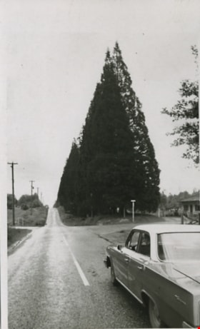
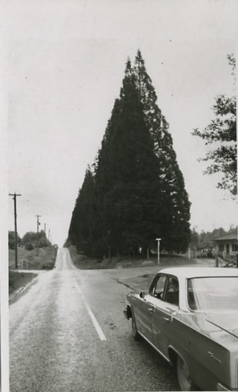
Scenic drive
https://search.heritageburnaby.ca/link/archivedescription56676
- Repository
- City of Burnaby Archives
- Date
- March 18, 1981
- Collection/Fonds
- Columbian Newspaper collection
- Description Level
- Item
- Physical Description
- 1 photograph : b&w ; 13.5 x 8.5 cm
- Scope and Content
- Photograph of a car driving down an unidentified road bordered along one side with large trees.
- Repository
- City of Burnaby Archives
- Date
- March 18, 1981
- Collection/Fonds
- Columbian Newspaper collection
- Physical Description
- 1 photograph : b&w ; 13.5 x 8.5 cm
- Description Level
- Item
- Record No.
- 480-457
- Access Restriction
- No restrictions
- Reproduction Restriction
- No restrictions
- Accession Number
- 2003-02
- Scope and Content
- Photograph of a car driving down an unidentified road bordered along one side with large trees.
- Subjects
- Geographic Features - Roads
- Media Type
- Photograph
- Photographer
- King, Basil
- Notes
- Title based on contents of photograph
- Note on verso of photograph reads: "The drive takes you" and "Scenic"
Images
![Sperling Avenue, [1987 or 1988] thumbnail](/media/hpo/_Data/_Archives_Images/_Unrestricted/204/204-805.jpg?width=280)
Sperling Avenue
https://search.heritageburnaby.ca/link/archivedescription35945
- Repository
- City of Burnaby Archives
- Date
- [1987 or 1988]
- Collection/Fonds
- Burnaby Historical Society fonds
- Description Level
- Item
- Physical Description
- 1 photograph : b&w ; 20.3 x 25.4 cm print
- Scope and Content
- Photograph of Sperling Avenue from above the hill at Deer Lake. This photograph was taken as a contemporary photograph to contrast item no. 204-749.
- Repository
- City of Burnaby Archives
- Date
- [1987 or 1988]
- Collection/Fonds
- Burnaby Historical Society fonds
- Subseries
- Pioneer Tales subseries
- Physical Description
- 1 photograph : b&w ; 20.3 x 25.4 cm print
- Description Level
- Item
- Record No.
- 204-805
- Access Restriction
- No restrictions
- Reproduction Restriction
- Reproduce for fair dealing purposes only
- Accession Number
- BHS1988-03
- Scope and Content
- Photograph of Sperling Avenue from above the hill at Deer Lake. This photograph was taken as a contemporary photograph to contrast item no. 204-749.
- Subjects
- Geographic Features - Roads
- Media Type
- Photograph
- Notes
- Title based on contents of photograph
- Geographic Access
- Sperling Avenue
- Historic Neighbourhood
- Burnaby Lake (Historic Neighbourhood)
- Planning Study Area
- Morley-Buckingham Area
Images
![Sperling Avenue, [1987 or 1988] thumbnail](/media/hpo/_Data/_Archives_Images/_Unrestricted/204/204-805.jpg)
8357 Tenth Avenue, 8350 and 8353 Eleventh Avenue
https://search.heritageburnaby.ca/link/archivedescription93724
- Repository
- City of Burnaby Archives
- Date
- 1989
- Collection/Fonds
- Grover, Elliott & Co. Ltd. fonds
- Description Level
- File
- Physical Description
- 24 photographs : col. negatives ; 35 mm
- Scope and Content
- Photographs of the exterior of the low-rise apartment complex located at 8357 10th Avenue and 8350 and 8353 11th Avenue and the laneway running between the buildings.
- Repository
- City of Burnaby Archives
- Date
- 1989
- Collection/Fonds
- Grover, Elliott & Co. Ltd. fonds
- Physical Description
- 24 photographs : col. negatives ; 35 mm
- Description Level
- File
- Record No.
- 622-013
- Access Restriction
- No restrictions
- Reproduction Restriction
- No restrictions
- Accession Number
- 2017-39
- Scope and Content
- Photographs of the exterior of the low-rise apartment complex located at 8357 10th Avenue and 8350 and 8353 11th Avenue and the laneway running between the buildings.
- Media Type
- Photograph
- Notes
- Transcribed title
- Title transcribed from original print envelope
- Geographic Access
- 10th Avenue
- 11th Avenue
- Street Address
- 8357 10th Avenue
- 8350 11th Avenue
- 8353 11th Avenue
- Historic Neighbourhood
- East Burnaby (Historic Neighbourhood)
- Planning Study Area
- Cariboo-Armstrong Area