Narrow Results By
3650 Bonneville Place
https://search.heritageburnaby.ca/link/archivedescription93737
- Repository
- City of Burnaby Archives
- Date
- March 1989
- Collection/Fonds
- Grover, Elliott & Co. Ltd. fonds
- Description Level
- File
- Physical Description
- 8 photographs : col. ; 10 cm x 15 cm
- Scope and Content
- Photographs of the commercial complex located at 3650 Bonneville Place. Phase I of the complex is complete and Phase II is under construction. Businesses visible in the photographs include Four Seasons Greenhouses and Shaw.
- Repository
- City of Burnaby Archives
- Date
- March 1989
- Collection/Fonds
- Grover, Elliott & Co. Ltd. fonds
- Physical Description
- 8 photographs : col. ; 10 cm x 15 cm
- Description Level
- File
- Record No.
- 622-022
- Access Restriction
- No restrictions
- Reproduction Restriction
- No restrictions
- Accession Number
- 2017-39
- Scope and Content
- Photographs of the commercial complex located at 3650 Bonneville Place. Phase I of the complex is complete and Phase II is under construction. Businesses visible in the photographs include Four Seasons Greenhouses and Shaw.
- Subjects
- Buildings - Commercial
- Construction
- Media Type
- Photograph
- Notes
- Transcribed title
- Title transcribed from sticky note adhered to photograph 622-022-1
- File no. 89-124-B
- Photograph 622-022-1 captions reads: "3650 Bonneville - south view"
- Photograph 622-022-2 caption reads: "North and east facade"
- Photograph 622-022-3 caption reads: "View north along Broadway Street; Note entry bridges"
- Photograph 622-022-4 caption reads: "Southern view along Broadway Street"
- Photograph 622-022-5 caption reads: "Front facade and main entry for Phase I"
- Photograph 622-022-6 caption reads: "Rear and loading facilities for Phase I"
- Photograph 622-022-7 caption reads: "View west to Phase II from entry driveway"
- Photograph 622-022-8 caption reads: "Site preparation for Phase I
- Photograph captions transcribed from the paper on which the photographs were originally adhered.
- Geographic Access
- Bonneville Place
- Street Address
- 3650 Bonneville Place
- Planning Study Area
- Lake City Area
Back yard of Mawhinney house
https://search.heritageburnaby.ca/link/museumdescription15561
- Repository
- Burnaby Village Museum
- Date
- August 1984
- Collection/Fonds
- Reverend Edward S. Gale fonds
- Description Level
- Item
- Physical Description
- 1 photograph : col. ; 10 x 15 cm
- Scope and Content
- Photograph of the back yard of the Mervin Mawhinney house looking north from the back deck before any of the subsequent landscaping was done by Reverend Gale. Tree on the right is a cherry tree. The house is located at 7667 Burris Street.
- Repository
- Burnaby Village Museum
- Collection/Fonds
- Reverend Edward S. Gale fonds
- Description Level
- Item
- Physical Description
- 1 photograph : col. ; 10 x 15 cm
- Scope and Content
- Photograph of the back yard of the Mervin Mawhinney house looking north from the back deck before any of the subsequent landscaping was done by Reverend Gale. Tree on the right is a cherry tree. The house is located at 7667 Burris Street.
- Geographic Access
- Burris Street
- Street Address
- 7667 Burris Street
- Accession Code
- BV018.9.27
- Access Restriction
- No restrictions
- Reproduction Restriction
- May be restricted by third party rights
- Date
- August 1984
- Media Type
- Photograph
- Planning Study Area
- Morley-Buckingham Area
- Scan Resolution
- 600
- Scan Date
- April 20, 2021
- Scale
- 100
- Notes
- Title based on contents of photograph
- Note in black ink on verso of photograph reads: "August '84"
Images

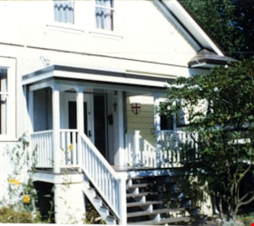
Front of Mawhinney house
https://search.heritageburnaby.ca/link/museumdescription15550
- Repository
- Burnaby Village Museum
- Date
- September 1988
- Collection/Fonds
- Reverend Edward S. Gale fonds
- Description Level
- Item
- Physical Description
- 1 photograph : col. ; 11.5 x 12.5 cm
- Scope and Content
- Photograph of the front entrance and porch of the Mawhinney house located at 7667 Burris Street in Burnaby. In 1988, the front path of the house was excavated to its original level and the porch was enlarged and altered to suit the style of the rest of the house; alterations were made to the carp…
- Repository
- Burnaby Village Museum
- Collection/Fonds
- Reverend Edward S. Gale fonds
- Description Level
- Item
- Physical Description
- 1 photograph : col. ; 11.5 x 12.5 cm
- Scope and Content
- Photograph of the front entrance and porch of the Mawhinney house located at 7667 Burris Street in Burnaby. In 1988, the front path of the house was excavated to its original level and the porch was enlarged and altered to suit the style of the rest of the house; alterations were made to the carport for the same reason. The house roof was replaced, and the exterior of the house was painted.
- Geographic Access
- Burris Street
- Street Address
- 7667 Burris Street
- Accession Code
- BV018.9.18
- Access Restriction
- No restrictions
- Reproduction Restriction
- May be restricted by third party rights
- Date
- September 1988
- Media Type
- Photograph
- Planning Study Area
- Morley-Buckingham Area
- Scan Resolution
- 600
- Scan Date
- April 15, 2021
- Scale
- 100
- Notes
- Title based on contents of photograph
- Note in black ink on verso of photograph reads: "Sept '88"
Images

![Yard at back of Mawhinney house, [1988] thumbnail](/media/hpo/_Data/_BVM_Images/2018/2018_0009_0025_001.jpg?width=280)
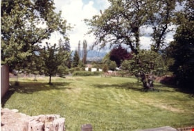
Yard at back of Mawhinney house
https://search.heritageburnaby.ca/link/museumdescription15559
- Repository
- Burnaby Village Museum
- Date
- [1988]
- Collection/Fonds
- Reverend Edward S. Gale fonds
- Description Level
- Item
- Physical Description
- 1 photograph : col. ; 9 x 11 cm
- Scope and Content
- Photograph of the back yard of the Mawhinney house located at 7667 Burris Street in Burnaby. An open grass covered area is in the foreground with gardens and trees, the house and mature trees are visible in the background.
- Repository
- Burnaby Village Museum
- Collection/Fonds
- Reverend Edward S. Gale fonds
- Description Level
- Item
- Physical Description
- 1 photograph : col. ; 9 x 11 cm
- Scope and Content
- Photograph of the back yard of the Mawhinney house located at 7667 Burris Street in Burnaby. An open grass covered area is in the foreground with gardens and trees, the house and mature trees are visible in the background.
- Geographic Access
- Burris Street
- Street Address
- 7667 Burris Street
- Accession Code
- BV018.9.25
- Access Restriction
- No restrictions
- Reproduction Restriction
- May be restricted by third party rights
- Date
- [1988]
- Media Type
- Photograph
- Planning Study Area
- Morley-Buckingham Area
- Related Material
- See also BV018.9.23 & BV018.9.24
- Scan Resolution
- 600
- Scan Date
- April 20, 2021
- Scale
- 100
- Notes
- Title based on contents of photograph
- Note in black ink on verso of photograph reads: “1990”
Images
![Yard at back of Mawhinney house, [1988] thumbnail](/media/hpo/_Data/_BVM_Images/2018/2018_0009_0025_001.jpg)