More like 'Boundary Road and Park Avenue station'
Narrow Results By
7183-7195 17th Ave and 7182-7194 18th Ave Burnaby
https://search.heritageburnaby.ca/link/archivedescription93893
- Repository
- City of Burnaby Archives
- Date
- June 1993
- Collection/Fonds
- Grover, Elliott & Co. Ltd. fonds
- Description Level
- File
- Physical Description
- 25 photographs : col. negatives ; 35 mm
- Scope and Content
- Photographs of a townhouse complex and surrounding area located at 7183-7195 17th Avenue and 7182-7194 18th Avenue - addresses that no longer exist.
- Repository
- City of Burnaby Archives
- Date
- June 1993
- Collection/Fonds
- Grover, Elliott & Co. Ltd. fonds
- Physical Description
- 25 photographs : col. negatives ; 35 mm
- Description Level
- File
- Record No.
- 622-076
- Access Restriction
- No restrictions
- Reproduction Restriction
- No restrictions
- Accession Number
- 2017-39
- Scope and Content
- Photographs of a townhouse complex and surrounding area located at 7183-7195 17th Avenue and 7182-7194 18th Avenue - addresses that no longer exist.
- Media Type
- Photograph
- Notes
- Transcribed title
- Title transcribed from envelope photographs were originally housed in
- File no. 93-291-B
- Photographer identified as "J.C."
- Geographic Access
- 17th Avenue
- 18th Avenue
- Historic Neighbourhood
- Edmonds (Historic Neighbourhood)
- Planning Study Area
- Stride Avenue Area
7641-7651 Royal Oak Ave
https://search.heritageburnaby.ca/link/archivedescription93769
- Repository
- City of Burnaby Archives
- Date
- July 30, 1992
- Collection/Fonds
- Grover, Elliott & Co. Ltd. fonds
- Description Level
- File
- Physical Description
- 25 photographs : col. negatives ; 35 mm
- Scope and Content
- Photographs of the commercial properties located between 7641 and 7651 Royal Oak Avenue. Stores visible in the photographs include: Buy Low Foods, Mega Movies, and Chevron service station.
- Repository
- City of Burnaby Archives
- Date
- July 30, 1992
- Collection/Fonds
- Grover, Elliott & Co. Ltd. fonds
- Physical Description
- 25 photographs : col. negatives ; 35 mm
- Description Level
- File
- Record No.
- 622-053
- Access Restriction
- No restrictions
- Reproduction Restriction
- No restrictions
- Accession Number
- 2017-39
- Scope and Content
- Photographs of the commercial properties located between 7641 and 7651 Royal Oak Avenue. Stores visible in the photographs include: Buy Low Foods, Mega Movies, and Chevron service station.
- Subjects
- Buildings - Commercial
- Buildings - Commercial - Service Stations
- Buildings - Commercial - Stores
- Geographic Features - Roads
- Media Type
- Photograph
- Photographer
- Young, Richard
- Notes
- Transcribed title
- Title transcribed from envelope photographs were originally housed in
- File no. 92-287-B
- Geographic Access
- Royal Oak Avenue
- Historic Neighbourhood
- Alta Vista (Historic Neighbourhood)
- Planning Study Area
- Maywood Area
7973-7993 Enterprise St
https://search.heritageburnaby.ca/link/archivedescription94296
- Repository
- City of Burnaby Archives
- Date
- December 1993
- Collection/Fonds
- Grover, Elliott & Co. Ltd. fonds
- Description Level
- File
- Physical Description
- 46 photographs : col. negatives ; 35 mm
- Scope and Content
- Photographs of the commercial complex located at 7973-7993 Enterprise Street.
- Repository
- City of Burnaby Archives
- Date
- December 1993
- Collection/Fonds
- Grover, Elliott & Co. Ltd. fonds
- Physical Description
- 46 photographs : col. negatives ; 35 mm
- Description Level
- File
- Record No.
- 622-081
- Access Restriction
- No restrictions
- Reproduction Restriction
- No restrictions
- Accession Number
- 2017-39
- Scope and Content
- Photographs of the commercial complex located at 7973-7993 Enterprise Street.
- Media Type
- Photograph
- Notes
- Transcribed title
- Title transcribed from envelope photographs were originally housed in
- File no. 93-464-B
- Photographer identified as "K.H."
- Geographic Access
- Enterprise Street
- Street Address
- 7973 Enterprise Street
- 7993 Enterprise Street
- Historic Neighbourhood
- Lozells (Historic Neighbourhood)
- Planning Study Area
- Government Road Area
8525 Baxter Place
https://search.heritageburnaby.ca/link/archivedescription93768
- Repository
- City of Burnaby Archives
- Date
- August 4, 1992
- Collection/Fonds
- Grover, Elliott & Co. Ltd. fonds
- Description Level
- File
- Physical Description
- 36 photographs : col. negatives ; 35 mm
- Scope and Content
- Photographs of the exterior of a commercial building located at 8525 Baxter Place.
- Repository
- City of Burnaby Archives
- Date
- August 4, 1992
- Collection/Fonds
- Grover, Elliott & Co. Ltd. fonds
- Physical Description
- 36 photographs : col. negatives ; 35 mm
- Description Level
- File
- Record No.
- 622-052
- Access Restriction
- No restrictions
- Reproduction Restriction
- No restrictions
- Accession Number
- 2017-39
- Scope and Content
- Photographs of the exterior of a commercial building located at 8525 Baxter Place.
- Media Type
- Photograph
- Photographer
- Young, Richard
- Notes
- Transcribed title
- Title transcribed from envelope photographs were originally housed in
- File no. 92-285-B
- Geographic Access
- Baxter Place
- Street Address
- 8525 Baxter Place
- Planning Study Area
- Lake City Area
8555 Baxter Place
https://search.heritageburnaby.ca/link/archivedescription93767
- Repository
- City of Burnaby Archives
- Date
- July 28, 1992
- Collection/Fonds
- Grover, Elliott & Co. Ltd. fonds
- Description Level
- File
- Physical Description
- 23 photographs : col. negatives ; 35 mm
- Scope and Content
- Photographs of commercial buildings along Baxter Place and an undeveloped property located at 8555 Baxter Place.
- Repository
- City of Burnaby Archives
- Date
- July 28, 1992
- Collection/Fonds
- Grover, Elliott & Co. Ltd. fonds
- Physical Description
- 23 photographs : col. negatives ; 35 mm
- Description Level
- File
- Record No.
- 622-051
- Access Restriction
- No restrictions
- Reproduction Restriction
- No restrictions
- Accession Number
- 2017-39
- Scope and Content
- Photographs of commercial buildings along Baxter Place and an undeveloped property located at 8555 Baxter Place.
- Media Type
- Photograph
- Photographer
- Young, Richard
- Notes
- Transcribed title
- Title transcribed from envelope photographs were originally housed in
- File no. 92-278-B
- Geographic Access
- Baxter Place
- Street Address
- 8555 Baxter Place
- Planning Study Area
- Lake City Area
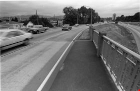
Burnaby road
https://search.heritageburnaby.ca/link/archivedescription79462
- Repository
- City of Burnaby Archives
- Date
- August 25, 1996
- Collection/Fonds
- Burnaby NewsLeader photograph collection
- Description Level
- Item
- Physical Description
- 1 photograph : b&w ; 16 x 24.5 cm
- Scope and Content
- Photograph of an unidentified road in Burnaby.
- Repository
- City of Burnaby Archives
- Date
- August 25, 1996
- Collection/Fonds
- Burnaby NewsLeader photograph collection
- Physical Description
- 1 photograph : b&w ; 16 x 24.5 cm
- Description Level
- Item
- Record No.
- 535-0394
- Access Restriction
- No restrictions
- Reproduction Restriction
- No reproduction permitted
- Accession Number
- 2012-11
- Scope and Content
- Photograph of an unidentified road in Burnaby.
- Subjects
- Geographic Features - Roads
- Media Type
- Photograph
- Photographer
- Gerein, Rob
- Notes
- Title based on contents of photograph
- Note in black ink on recto of photograph reads: "Bby Mario 2091 35% Bby p. 4"
- Trim marks and/or reproduction instructions on recto (scan is cropped)
Images
![Curtis Street, [1990] thumbnail](/media/hpo/_Data/_Archives_Images/_Unrestricted/371/439-001.jpg?width=280)
Curtis Street
https://search.heritageburnaby.ca/link/archivedescription38430
- Repository
- City of Burnaby Archives
- Date
- [1990]
- Collection/Fonds
- Burnaby Historical Society fonds
- Description Level
- Item
- Physical Description
- 1 photograph : colour ; 10 x 15.1 cm
- Scope and Content
- Photograph looking east up Curtis Street towards Burnaby Mountain.
- Repository
- City of Burnaby Archives
- Date
- [1990]
- Collection/Fonds
- Burnaby Historical Society fonds
- Subseries
- Photographs subseries
- Physical Description
- 1 photograph : colour ; 10 x 15.1 cm
- Description Level
- Item
- Record No.
- 439-001
- Access Restriction
- No restrictions
- Reproduction Restriction
- Reproduce for fair dealing purposes only
- Accession Number
- BHS2007-04
- Scope and Content
- Photograph looking east up Curtis Street towards Burnaby Mountain.
- Subjects
- Geographic Features - Roads
- Media Type
- Photograph
- Notes
- Title based on contents of photograph.
- Geographic Access
- Curtis Street
- Historic Neighbourhood
- Lochdale (Historic Neighbourhood)
- Planning Study Area
- Lochdale Area
Images
![Curtis Street, [1990] thumbnail](/media/hpo/_Data/_Archives_Images/_Unrestricted/371/439-001.jpg)
![Curtis Street, [1990] thumbnail](/media/hpo/_Data/_Archives_Images/_Unrestricted/371/439-002.jpg?width=280)
Curtis Street
https://search.heritageburnaby.ca/link/archivedescription39750
- Repository
- City of Burnaby Archives
- Date
- [1990]
- Collection/Fonds
- Burnaby Historical Society fonds
- Description Level
- Item
- Physical Description
- 1 photograph : col. ; 10 x 15.1 cm
- Scope and Content
- Photograph taken looking east on Curtis Street towards Burnaby Mountain.
- Repository
- City of Burnaby Archives
- Date
- [1990]
- Collection/Fonds
- Burnaby Historical Society fonds
- Subseries
- Photographs subseries
- Physical Description
- 1 photograph : col. ; 10 x 15.1 cm
- Description Level
- Item
- Record No.
- 439-002
- Access Restriction
- No restrictions
- Reproduction Restriction
- Reproduce for fair dealing purposes only
- Accession Number
- BHS2007-04
- Scope and Content
- Photograph taken looking east on Curtis Street towards Burnaby Mountain.
- Subjects
- Geographic Features - Roads
- Media Type
- Photograph
- Notes
- Title based on contents of photograph
- Geographic Access
- Curtis Street
- Historic Neighbourhood
- Lochdale (Historic Neighbourhood)
- Planning Study Area
- Lochdale Area
Images
![Curtis Street, [1990] thumbnail](/media/hpo/_Data/_Archives_Images/_Unrestricted/371/439-002.jpg)
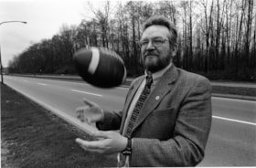
Derek Corrigan
https://search.heritageburnaby.ca/link/archivedescription80900
- Repository
- City of Burnaby Archives
- Date
- March 15, 1998
- Collection/Fonds
- Burnaby NewsLeader photograph collection
- Description Level
- Item
- Physical Description
- 1 photograph : b&w ; 15.5 x 23.5 cm
- Scope and Content
- Photograph of Burnaby Councillor (later mayor) Derek Corrigan tossing a football in the air beside Kensington Avenue.
- Repository
- City of Burnaby Archives
- Date
- March 15, 1998
- Collection/Fonds
- Burnaby NewsLeader photograph collection
- Physical Description
- 1 photograph : b&w ; 15.5 x 23.5 cm
- Description Level
- Item
- Record No.
- 535-1134
- Access Restriction
- No restrictions
- Reproduction Restriction
- No reproduction permitted
- Accession Number
- 2012-11
- Scope and Content
- Photograph of Burnaby Councillor (later mayor) Derek Corrigan tossing a football in the air beside Kensington Avenue.
- Subjects
- Officials - Alderman and Councillors
- Officials - Mayors and Reeves
- Geographic Features - Roads
- Names
- Corrigan, Derek
- Media Type
- Photograph
- Photographer
- Bartel, Mario
- Notes
- Title based on contents of photograph
- Note in blue ink on recto of photograph reads: "537 Bby Mario Bby 3 72%"
- Trim marks and/or reproduction instructions on recto (scan is cropped)
- Accompanying caption reads: "March 15, 1998 537: / Burnaby Councillor Derek Corrigan sees the Burnaby Lake sports complex as the choice for amateur sports groups in BC. The article discusses the $16.9 million outdoor complex to be completed by fall 1999."
Images
Henning dr. [sic] Burnaby
https://search.heritageburnaby.ca/link/archivedescription93838
- Repository
- City of Burnaby Archives
- Date
- January 1993
- Collection/Fonds
- Grover, Elliott & Co. Ltd. fonds
- Description Level
- File
- Physical Description
- 24 photographs : col. negatives ; 35 mm
- Scope and Content
- Photographs of the Bridge Business Park under construction. The Bridge Business Park is located between Lougheed Highway and Henning Drive and Boundary Road and Gilmore Avenue.
- Repository
- City of Burnaby Archives
- Date
- January 1993
- Collection/Fonds
- Grover, Elliott & Co. Ltd. fonds
- Physical Description
- 24 photographs : col. negatives ; 35 mm
- Description Level
- File
- Record No.
- 622-063
- Access Restriction
- No restrictions
- Reproduction Restriction
- No restrictions
- Accession Number
- 2017-39
- Scope and Content
- Photographs of the Bridge Business Park under construction. The Bridge Business Park is located between Lougheed Highway and Henning Drive and Boundary Road and Gilmore Avenue.
- Subjects
- Geographic Features - Roads
- Construction
- Media Type
- Photograph
- Notes
- Transcribed title
- Title transcribed from envelope photographs were originally housed in
- File no. 93-031-B
- Photographer identified as "K.D."
- Geographic Access
- Henning Drive
- Historic Neighbourhood
- Broadview (Historic Neighbourhood)
- Planning Study Area
- West Central Valley Area
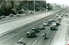
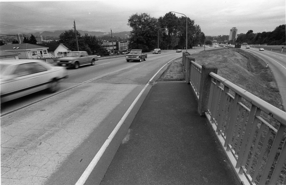
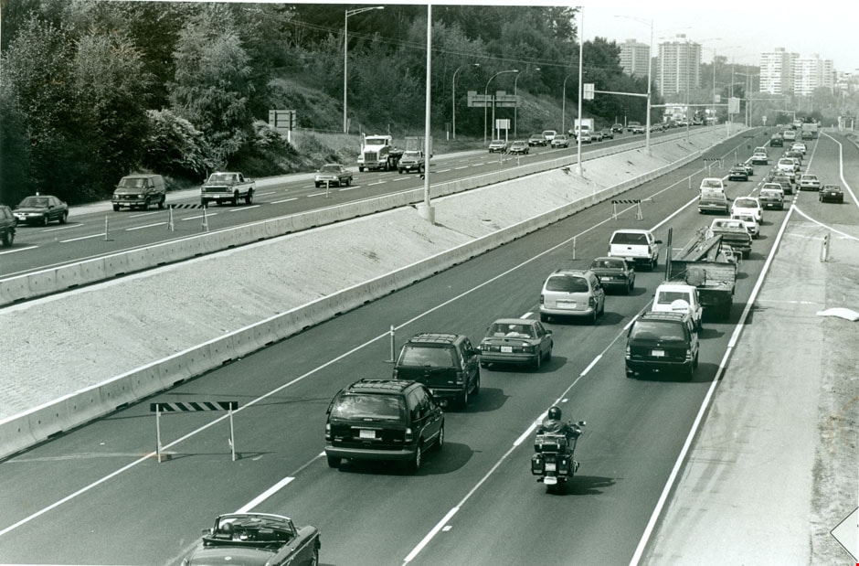
Highway 1
https://search.heritageburnaby.ca/link/archivedescription79313
- Repository
- City of Burnaby Archives
- Date
- July 7, 1996
- Collection/Fonds
- Burnaby NewsLeader photograph collection
- Description Level
- Item
- Physical Description
- 1 photograph : b&w ; 16.5 x 24.5 cm
- Scope and Content
- Photograph of traffic on Highway 1 in Burnaby.
- Repository
- City of Burnaby Archives
- Date
- July 7, 1996
- Collection/Fonds
- Burnaby NewsLeader photograph collection
- Physical Description
- 1 photograph : b&w ; 16.5 x 24.5 cm
- Description Level
- Item
- Record No.
- 535-0341
- Access Restriction
- No restrictions
- Reproduction Restriction
- No reproduction permitted
- Accession Number
- 2012-11
- Scope and Content
- Photograph of traffic on Highway 1 in Burnaby.
- Subjects
- Geographic Features - Roads
- Media Type
- Photograph
- Photographer
- Bartel, Mario
- Notes
- Title based on contents of photograph
- Note in black ink on recto of photograph reads: "1757 Bby Mario / Bby 3 - 50%"
- Trim marks and/or reproduction instructions on recto (scan is cropped)
Images
![Intersection, [1990] thumbnail](/media/hpo/_Data/_Archives_Images/_Unrestricted/371/422-023.jpg?width=280)
Intersection
https://search.heritageburnaby.ca/link/archivedescription38392
- Repository
- City of Burnaby Archives
- Date
- [1990]
- Collection/Fonds
- Burnaby Historical Society fonds
- Description Level
- Item
- Physical Description
- 1 photograph : col. ; 9 x 13 cm
- Scope and Content
- Photograph of a stop sign at an unidentified intersection - probably in the Deer Lake Park area.
- Repository
- City of Burnaby Archives
- Date
- [1990]
- Collection/Fonds
- Burnaby Historical Society fonds
- Subseries
- Municipal record subseries
- Physical Description
- 1 photograph : col. ; 9 x 13 cm
- Description Level
- Item
- Record No.
- 422-023
- Access Restriction
- No restrictions
- Reproduction Restriction
- Reproduce for fair dealing purposes only
- Accession Number
- BHS2001-09
- Scope and Content
- Photograph of a stop sign at an unidentified intersection - probably in the Deer Lake Park area.
- Subjects
- Geographic Features - Roads
- Media Type
- Photograph
- Photographer
- Wolf, Jim
- Notes
- Title based on contents of photograph.
Images
![Intersection, [1990] thumbnail](/media/hpo/_Data/_Archives_Images/_Unrestricted/371/422-023.jpg)
![Land surveyor on a road, [1999] thumbnail](/media/hpo/_Data/_Archives_Images/_Unrestricted/535/535-3313.jpg?width=280)
Land surveyor on a road
https://search.heritageburnaby.ca/link/archivedescription98246
- Repository
- City of Burnaby Archives
- Date
- [1999]
- Collection/Fonds
- Burnaby NewsLeader photograph collection
- Description Level
- Item
- Physical Description
- 1 photograph (tiff) : b&w
- Scope and Content
- Photograph of an unidentified land surveyor standing behind a land surveying total station at the curve of a road.
- Repository
- City of Burnaby Archives
- Date
- [1999]
- Collection/Fonds
- Burnaby NewsLeader photograph collection
- Physical Description
- 1 photograph (tiff) : b&w
- Description Level
- Item
- Record No.
- 535-3313
- Access Restriction
- No restrictions
- Reproduction Restriction
- No restrictions
- Accession Number
- 2018-12
- Scope and Content
- Photograph of an unidentified land surveyor standing behind a land surveying total station at the curve of a road.
- Media Type
- Photograph
- Notes
- Title based on contents of photograph
- Collected by editorial for use in a September 1999 issue of the Burnaby NewsLeader
Images
![Land surveyor on a road, [1999] thumbnail](/media/hpo/_Data/_Archives_Images/_Unrestricted/535/535-3313.jpg)

Marine Drive bypass
https://search.heritageburnaby.ca/link/archivedescription45661
- Repository
- City of Burnaby Archives
- Date
- March 18, 1981
- Collection/Fonds
- Columbian Newspaper collection
- Description Level
- Item
- Physical Description
- 1 photograph : b&w ; 24.5 x 16.5 cm
- Scope and Content
- Aerial photograph of the Marine Drive bypass into Burnaby.
- Repository
- City of Burnaby Archives
- Date
- March 18, 1981
- Collection/Fonds
- Columbian Newspaper collection
- Physical Description
- 1 photograph : b&w ; 24.5 x 16.5 cm
- Description Level
- Item
- Record No.
- 480-555
- Access Restriction
- No restrictions
- Reproduction Restriction
- Reproduce for fair dealing purposes only
- Accession Number
- 2003-02
- Scope and Content
- Aerial photograph of the Marine Drive bypass into Burnaby.
- Media Type
- Photograph
- Photographer
- Hodge, Craig
- Notes
- Title based on contents of photograph
- Geographic Access
- Marine Drive
- Historic Neighbourhood
- Fraser Arm (Historic Neighbourhood)
- Planning Study Area
- Big Bend Area
Images

North Fraser Way / Northbrook Court
https://search.heritageburnaby.ca/link/archivedescription93736
- Repository
- City of Burnaby Archives
- Date
- 1989
- Collection/Fonds
- Grover, Elliott & Co. Ltd. fonds
- Description Level
- File
- Physical Description
- 16 photographs : col. negatives ; 35 mm
- Scope and Content
- Photographs of an undeveloped property loacated at the corner of North Fraser Way and Northbrook Court.
- Repository
- City of Burnaby Archives
- Date
- 1989
- Collection/Fonds
- Grover, Elliott & Co. Ltd. fonds
- Physical Description
- 16 photographs : col. negatives ; 35 mm
- Description Level
- File
- Record No.
- 622-021
- Access Restriction
- No restrictions
- Reproduction Restriction
- No restrictions
- Accession Number
- 2017-39
- Scope and Content
- Photographs of an undeveloped property loacated at the corner of North Fraser Way and Northbrook Court.
- Subjects
- Land Clearing
- Geographic Features - Roads
- Media Type
- Photograph
- Notes
- Transcribed title
- Title transcribed from original print envelope
- File no. 89-040-B
- Geographic Access
- Northbrook Court
- North Fraser Way
- Historic Neighbourhood
- Fraser Arm (Historic Neighbourhood)
- Planning Study Area
- Big Bend Area
![Police officer at Royal Oak and Kingsway, [1999] thumbnail](/media/hpo/_Data/_Archives_Images/_Unrestricted/535/535-3258.jpg?width=280)
Police officer at Royal Oak and Kingsway
https://search.heritageburnaby.ca/link/archivedescription98180
- Repository
- City of Burnaby Archives
- Date
- [1999]
- Collection/Fonds
- Burnaby NewsLeader photograph collection
- Description Level
- Item
- Physical Description
- 1 photograph (tiff) : col.
- Scope and Content
- Photograph of a Burnaby RCMP officer wearing a reflective vest and standing on the sidewalk by a bus stop on Kingsway, across the street from a Safeway, at the intersection of Royal Oak Avenue and Kingsway.
- Repository
- City of Burnaby Archives
- Date
- [1999]
- Collection/Fonds
- Burnaby NewsLeader photograph collection
- Physical Description
- 1 photograph (tiff) : col.
- Description Level
- Item
- Record No.
- 535-3258
- Access Restriction
- No restrictions
- Reproduction Restriction
- No restrictions
- Accession Number
- 2018-12
- Scope and Content
- Photograph of a Burnaby RCMP officer wearing a reflective vest and standing on the sidewalk by a bus stop on Kingsway, across the street from a Safeway, at the intersection of Royal Oak Avenue and Kingsway.
- Subjects
- Occupations - Police Officers
- Geographic Features - Roads
- Buildings - Commercial - Grocery Stores
- Media Type
- Photograph
- Notes
- Title based on contents of photograph
- Collected by editorial for use in a July 1999 issue of the Burnaby NewsLeader
- Geographic Access
- Kingsway
- Royal Oak Avenue
- Historic Neighbourhood
- Central Park (Historic Neighbourhood)
- Planning Study Area
- Windsor Area
Images
![Police officer at Royal Oak and Kingsway, [1999] thumbnail](/media/hpo/_Data/_Archives_Images/_Unrestricted/535/535-3258.jpg)
"Prospero Centre" / 4361 Kingsway
https://search.heritageburnaby.ca/link/archivedescription93749
- Repository
- City of Burnaby Archives
- Date
- 1989
- Collection/Fonds
- Grover, Elliott & Co. Ltd. fonds
- Description Level
- File
- Physical Description
- 24 photographs : col. negatives ; 35 mm
- Scope and Content
- Photographs of Prospero Centre, a commercial complex located at 4361 Kingsway.
- Repository
- City of Burnaby Archives
- Date
- 1989
- Collection/Fonds
- Grover, Elliott & Co. Ltd. fonds
- Physical Description
- 24 photographs : col. negatives ; 35 mm
- Description Level
- File
- Record No.
- 622-034
- Access Restriction
- No restrictions
- Reproduction Restriction
- No restrictions
- Accession Number
- 2017-39
- Scope and Content
- Photographs of Prospero Centre, a commercial complex located at 4361 Kingsway.
- Media Type
- Photograph
- Notes
- Transcribed title
- Title transcribed from print envelope photographs were originally housed in
- File no. 89-554-B
- Geographic Access
- Kingsway
- Street Address
- 4361 Kingsway
- Historic Neighbourhood
- Central Park (Historic Neighbourhood)
- Planning Study Area
- Garden Village Area
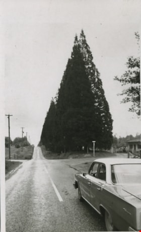
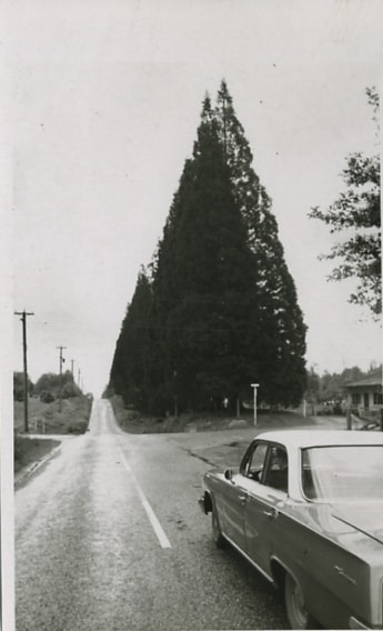
Scenic drive
https://search.heritageburnaby.ca/link/archivedescription56676
- Repository
- City of Burnaby Archives
- Date
- March 18, 1981
- Collection/Fonds
- Columbian Newspaper collection
- Description Level
- Item
- Physical Description
- 1 photograph : b&w ; 13.5 x 8.5 cm
- Scope and Content
- Photograph of a car driving down an unidentified road bordered along one side with large trees.
- Repository
- City of Burnaby Archives
- Date
- March 18, 1981
- Collection/Fonds
- Columbian Newspaper collection
- Physical Description
- 1 photograph : b&w ; 13.5 x 8.5 cm
- Description Level
- Item
- Record No.
- 480-457
- Access Restriction
- No restrictions
- Reproduction Restriction
- No restrictions
- Accession Number
- 2003-02
- Scope and Content
- Photograph of a car driving down an unidentified road bordered along one side with large trees.
- Subjects
- Geographic Features - Roads
- Media Type
- Photograph
- Photographer
- King, Basil
- Notes
- Title based on contents of photograph
- Note on verso of photograph reads: "The drive takes you" and "Scenic"
Images
![Sperling Avenue, [1987 or 1988] thumbnail](/media/hpo/_Data/_Archives_Images/_Unrestricted/204/204-805.jpg?width=280)
Sperling Avenue
https://search.heritageburnaby.ca/link/archivedescription35945
- Repository
- City of Burnaby Archives
- Date
- [1987 or 1988]
- Collection/Fonds
- Burnaby Historical Society fonds
- Description Level
- Item
- Physical Description
- 1 photograph : b&w ; 20.3 x 25.4 cm print
- Scope and Content
- Photograph of Sperling Avenue from above the hill at Deer Lake. This photograph was taken as a contemporary photograph to contrast item no. 204-749.
- Repository
- City of Burnaby Archives
- Date
- [1987 or 1988]
- Collection/Fonds
- Burnaby Historical Society fonds
- Subseries
- Pioneer Tales subseries
- Physical Description
- 1 photograph : b&w ; 20.3 x 25.4 cm print
- Description Level
- Item
- Record No.
- 204-805
- Access Restriction
- No restrictions
- Reproduction Restriction
- Reproduce for fair dealing purposes only
- Accession Number
- BHS1988-03
- Scope and Content
- Photograph of Sperling Avenue from above the hill at Deer Lake. This photograph was taken as a contemporary photograph to contrast item no. 204-749.
- Subjects
- Geographic Features - Roads
- Media Type
- Photograph
- Notes
- Title based on contents of photograph
- Geographic Access
- Sperling Avenue
- Historic Neighbourhood
- Burnaby Lake (Historic Neighbourhood)
- Planning Study Area
- Morley-Buckingham Area
Images
![Sperling Avenue, [1987 or 1988] thumbnail](/media/hpo/_Data/_Archives_Images/_Unrestricted/204/204-805.jpg)
Strata Lots 5 to 8 / 3965 Kingsway
https://search.heritageburnaby.ca/link/archivedescription93748
- Repository
- City of Burnaby Archives
- Date
- 1989
- Collection/Fonds
- Grover, Elliott & Co. Ltd. fonds
- Description Level
- File
- Physical Description
- 19 photographs : col. negatives ; 35 mm
- Scope and Content
- Photographs of the exterior of the three-storey commercial building located at 3965 Kingsway.
- Repository
- City of Burnaby Archives
- Date
- 1989
- Collection/Fonds
- Grover, Elliott & Co. Ltd. fonds
- Physical Description
- 19 photographs : col. negatives ; 35 mm
- Description Level
- File
- Record No.
- 622-033
- Access Restriction
- No restrictions
- Reproduction Restriction
- No restrictions
- Accession Number
- 2017-39
- Scope and Content
- Photographs of the exterior of the three-storey commercial building located at 3965 Kingsway.
- Media Type
- Photograph
- Notes
- Transcribed title
- Title transcribed from print envelope photographs were originally housed in
- File no. 89-542-B
- Geographic Access
- Kingsway
- Street Address
- 3965 Kingsway
- Historic Neighbourhood
- Central Park (Historic Neighbourhood)
- Planning Study Area
- Garden Village Area