Narrow Results By
Subject
- Academic Disciplines 1
- Accidents 1
- Accidents - Train Accidents
- Adminstrative Groups - Committees 4
- Adornment - Jewelry 1
- Advertising Medium 1
- Advertising Medium - Flyer 4
- Advertising Medium - Poster 15
- Advertising Medium - Signs and Signboards 73
- Aerial Photographs 46
- Agriculture 2
- Agriculture - Farms 60

Bonsor Park Pool
https://search.heritageburnaby.ca/link/archivedescription79739
- Repository
- City of Burnaby Archives
- Date
- September 13, 1976
- Collection/Fonds
- Burnaby Public Library Contemporary Visual Archive Project
- Description Level
- Item
- Physical Description
- 1 photograph : b&w ; 11 x 16 cm mounted on cardboard
- Scope and Content
- Photograph shows Bonsor Park Pool, at 4780 Brief Street (old address), between Fern Avenue and Bonsor Avenue. It was building it 1972 and 1973. The pool complex features an olympic size pool, dressing rooms, staff offices and gymnasium style bleachers that seat 250-500 spectators at pool-side.
- Repository
- City of Burnaby Archives
- Date
- September 13, 1976
- Collection/Fonds
- Burnaby Public Library Contemporary Visual Archive Project
- Physical Description
- 1 photograph : b&w ; 11 x 16 cm mounted on cardboard
- Description Level
- Item
- Record No.
- 556-411
- Access Restriction
- No restrictions
- Reproduction Restriction
- Reproduce for fair dealing purposes only
- Accession Number
- 2013-13
- Scope and Content
- Photograph shows Bonsor Park Pool, at 4780 Brief Street (old address), between Fern Avenue and Bonsor Avenue. It was building it 1972 and 1973. The pool complex features an olympic size pool, dressing rooms, staff offices and gymnasium style bleachers that seat 250-500 spectators at pool-side.
- Media Type
- Photograph
- Photographer
- McCarron, John
- Notes
- Scope note taken directly from BPL photograph description.
- 1 b&w copy negative : 10 x 12.5 cm accompanying
- Geographic Access
- Bonsor Avenue
- Street Address
- 6550 Bonsor Avenue
- Historic Neighbourhood
- Central Park (Historic Neighbourhood)
- Planning Study Area
- Marlborough Area
Images


Swimming Pool Robert Burnaby Park
https://search.heritageburnaby.ca/link/archivedescription93641
- Repository
- City of Burnaby Archives
- Date
- November 19, 1977
- Collection/Fonds
- Burnaby Public Library Contemporary Visual Archive Project
- Description Level
- Item
- Physical Description
- 1 photograph : b&w ; 12.5 x 17.5 cm
- Scope and Content
- Photograph of the swimming pool and adjacent pool building in Robert Burnaby Park. The photograph is taken facing north, from a nearby high point.
- Repository
- City of Burnaby Archives
- Date
- November 19, 1977
- Collection/Fonds
- Burnaby Public Library Contemporary Visual Archive Project
- Physical Description
- 1 photograph : b&w ; 12.5 x 17.5 cm
- Description Level
- Item
- Record No.
- 556-598
- Access Restriction
- No restrictions
- Reproduction Restriction
- Reproduce for fair dealing purposes only
- Accession Number
- 2017-57
- Scope and Content
- Photograph of the swimming pool and adjacent pool building in Robert Burnaby Park. The photograph is taken facing north, from a nearby high point.
- Subjects
- Geographic Features - Parks
- Buildings - Recreational - Outdoor Swimming Pools
- Buildings - Recreational - Swimming Pools
- Media Type
- Photograph
- Photographer
- Surridge, Jack
- Notes
- Title taken from project information form
- Accompanied by a project information form and 1 photograph (b&w negative ; 9.5 x 12.5 cm)
- BPL no. 48
- Geographic Access
- Robert Burnaby Park
- Street Address
- 8175 Wedgewood Street
- Historic Neighbourhood
- East Burnaby (Historic Neighbourhood)
- Planning Study Area
- Lakeview-Mayfield Area
Images

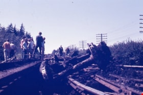
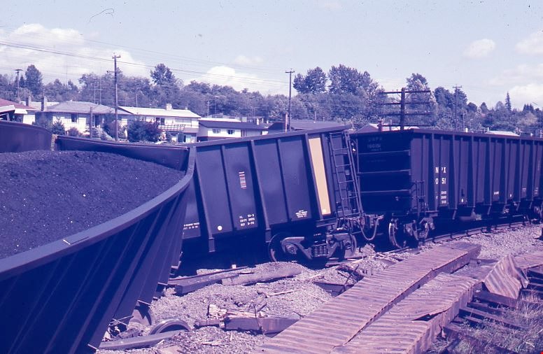
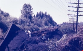
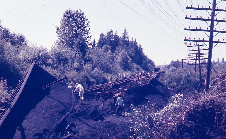
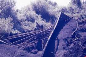
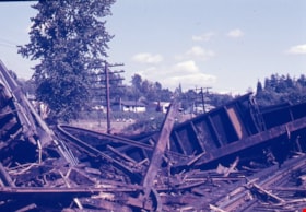
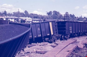
Train wreck at Kensington Avenue
https://search.heritageburnaby.ca/link/museumdescription4306
- Repository
- Burnaby Village Museum
- Date
- 16 Aug. 1970
- Collection/Fonds
- Burnaby Village Museum Photograph collection
- Description Level
- Item
- Physical Description
- 1 photograph : col. ; 35 mm
- Scope and Content
- Photograph of a train wreck at Kensington Avenue and the Lougheed Highway on Aug 16, 1970. The Farmer family was living at Buchanan Street and Holdom Avenue and they heard the train wreck when it happened.
- Repository
- Burnaby Village Museum
- Collection/Fonds
- Burnaby Village Museum Photograph collection
- Description Level
- Item
- Physical Description
- 1 photograph : col. ; 35 mm
- Material Details
- The slide was processed in Canachrome by Mortifee Munshaw.
- Handwritten text in ink on slide frame reads: "Train Wreck / Aug 16 /70".
- Scope and Content
- Photograph of a train wreck at Kensington Avenue and the Lougheed Highway on Aug 16, 1970. The Farmer family was living at Buchanan Street and Holdom Avenue and they heard the train wreck when it happened.
- Names
- Farmer, Joanne
- Geographic Access
- Kensington Avenue
- Lougheed Highway
- Accession Code
- BV017.42.1
- Access Restriction
- No restrictions
- Reproduction Restriction
- No known restrictions
- Date
- 16 Aug. 1970
- Media Type
- Photograph
- Planning Study Area
- Brentwood Area
- Scan Resolution
- 600
- Scan Date
- 05-Jun-2018
- Notes
- Title based on contents of photograph
Images

Train wreck at Kensington Avenue
https://search.heritageburnaby.ca/link/museumdescription4307
- Repository
- Burnaby Village Museum
- Date
- 16 Aug. 1970
- Collection/Fonds
- Burnaby Village Museum Photograph collection
- Description Level
- Item
- Physical Description
- 1 photograph : col. ; 35 mm
- Scope and Content
- Photograph of a train wreck at Kensington Avenue and the Lougheed Highway on Aug 16, 1970. The Farmer family was living at Buchanan Street and Holdom Avenue and they heard the train wreck when it happened.
- Repository
- Burnaby Village Museum
- Collection/Fonds
- Burnaby Village Museum Photograph collection
- Description Level
- Item
- Physical Description
- 1 photograph : col. ; 35 mm
- Material Details
- The slide was processed in Canachrome by Mortifee Munshaw.
- Handwritten text in ink on slide frame reads: "Train Wreck / Aug 16 /70".
- Scope and Content
- Photograph of a train wreck at Kensington Avenue and the Lougheed Highway on Aug 16, 1970. The Farmer family was living at Buchanan Street and Holdom Avenue and they heard the train wreck when it happened.
- Names
- Farmer, Joanne
- Geographic Access
- Kensington Avenue
- Lougheed Highway
- Accession Code
- BV017.42.2
- Access Restriction
- No restrictions
- Reproduction Restriction
- No known restrictions
- Date
- 16 Aug. 1970
- Media Type
- Photograph
- Planning Study Area
- Brentwood Area
- Scan Resolution
- 600
- Scan Date
- 05-Jun-2018
- Notes
- Title based on contents of photograph
Images
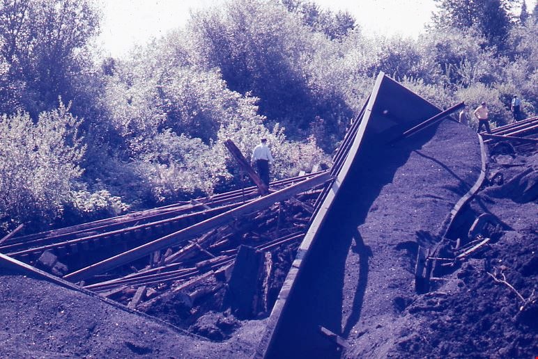
Train wreck at Kensington Avenue
https://search.heritageburnaby.ca/link/museumdescription4308
- Repository
- Burnaby Village Museum
- Date
- 16 Aug. 1970
- Collection/Fonds
- Burnaby Village Museum Photograph collection
- Description Level
- Item
- Physical Description
- 1 photograph : col. ; 35 mm
- Scope and Content
- Photograph of a train wreck at Kensington Avenue and the Lougheed Highway on Aug 16, 1970. The Farmer family was living at Buchanan Street and Holdom Avenue and they heard the train wreck when it happened.
- Repository
- Burnaby Village Museum
- Collection/Fonds
- Burnaby Village Museum Photograph collection
- Description Level
- Item
- Physical Description
- 1 photograph : col. ; 35 mm
- Material Details
- The slide was processed in Canachrome by Mortifee Munshaw.
- Handwritten text in ink on slide frame reads: "Train Wreck / Aug 16 /70 / Lougheed Hiway".
- Scope and Content
- Photograph of a train wreck at Kensington Avenue and the Lougheed Highway on Aug 16, 1970. The Farmer family was living at Buchanan Street and Holdom Avenue and they heard the train wreck when it happened.
- Names
- Farmer, Joanne
- Geographic Access
- Kensington Avenue
- Lougheed Highway
- Accession Code
- BV017.42.3
- Access Restriction
- No restrictions
- Reproduction Restriction
- No known restrictions
- Date
- 16 Aug. 1970
- Media Type
- Photograph
- Planning Study Area
- Brentwood Area
- Scan Resolution
- 600
- Scan Date
- 05-Jun-2018
- Notes
- Title based on contents of photograph
Images
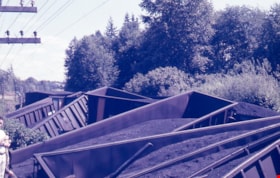
Train wreck at Kensington Avenue
https://search.heritageburnaby.ca/link/museumdescription4309
- Repository
- Burnaby Village Museum
- Date
- 16 Aug. 1970
- Collection/Fonds
- Burnaby Village Museum Photograph collection
- Description Level
- Item
- Physical Description
- 1 photograph : col. ; 35 mm
- Scope and Content
- Photograph of a train wreck at Kensington Avenue and the Lougheed Highway on Aug 16, 1970. The Farmer family was living at Buchanan Street and Holdom Avenue and they heard the train wreck when it happened.
- Repository
- Burnaby Village Museum
- Collection/Fonds
- Burnaby Village Museum Photograph collection
- Description Level
- Item
- Physical Description
- 1 photograph : col. ; 35 mm
- Material Details
- The slide was processed in Canachrome by Mortifee Munshaw.
- Handwritten text in ink on slide frame reads: "Train Wreck / Aug 16 /70".
- Scope and Content
- Photograph of a train wreck at Kensington Avenue and the Lougheed Highway on Aug 16, 1970. The Farmer family was living at Buchanan Street and Holdom Avenue and they heard the train wreck when it happened.
- Names
- Farmer, Joanne
- Geographic Access
- Kensington Avenue
- Lougheed Highway
- Accession Code
- BV017.42.4
- Access Restriction
- No restrictions
- Reproduction Restriction
- No known restrictions
- Date
- 16 Aug. 1970
- Media Type
- Photograph
- Planning Study Area
- Brentwood Area
- Scan Resolution
- 600
- Scan Date
- 05-Jun-2018
- Notes
- Title based on contents of photograph
Images
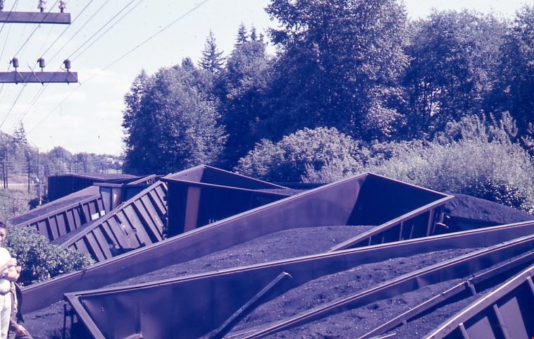
Train wreck at Kensington Avenue
https://search.heritageburnaby.ca/link/museumdescription4310
- Repository
- Burnaby Village Museum
- Date
- 16 Aug. 1970
- Collection/Fonds
- Burnaby Village Museum Photograph collection
- Description Level
- Item
- Physical Description
- 1 photograph : col. ; 35 mm
- Scope and Content
- Photograph of a train wreck at Kensington Avenue and the Lougheed Highway on Aug 16, 1970. The Farmer family was living at Buchanan Street and Holdom Avenue and they heard the train wreck when it happened.
- Repository
- Burnaby Village Museum
- Collection/Fonds
- Burnaby Village Museum Photograph collection
- Description Level
- Item
- Physical Description
- 1 photograph : col. ; 35 mm
- Material Details
- The slide was processed in Canachrome by Mortifee Munshaw.
- Handwritten text in ink on slide frame reads: "Train Wreck / Aug 16 /70".
- Scope and Content
- Photograph of a train wreck at Kensington Avenue and the Lougheed Highway on Aug 16, 1970. The Farmer family was living at Buchanan Street and Holdom Avenue and they heard the train wreck when it happened.
- Names
- Farmer, Joanne
- Geographic Access
- Kensington Avenue
- Lougheed Highway
- Accession Code
- BV017.42.5
- Access Restriction
- No restrictions
- Reproduction Restriction
- No known restrictions
- Date
- 16 Aug. 1970
- Media Type
- Photograph
- Planning Study Area
- Brentwood Area
- Scan Resolution
- 600
- Scan Date
- 05-Jun-2018
- Notes
- Title based on contents of photograph
Images

Train wreck at Kensington Avenue
https://search.heritageburnaby.ca/link/museumdescription4311
- Repository
- Burnaby Village Museum
- Date
- 16 Aug. 1970
- Collection/Fonds
- Burnaby Village Museum Photograph collection
- Description Level
- Item
- Physical Description
- 1 photograph : col. ; 35 mm
- Scope and Content
- Photograph of a train wreck at Kensington Avenue and the Lougheed Highway on Aug 16, 1970. The Farmer family was living at Buchanan Street and Holdom Avenue and they heard the train wreck when it happened.
- Repository
- Burnaby Village Museum
- Collection/Fonds
- Burnaby Village Museum Photograph collection
- Description Level
- Item
- Physical Description
- 1 photograph : col. ; 35 mm
- Material Details
- The slide was processed in Canachrome by Mortifee Munshaw.
- Handwritten text in ink on slide frame reads: "Train Wreck / Aug 16 /70".
- Scope and Content
- Photograph of a train wreck at Kensington Avenue and the Lougheed Highway on Aug 16, 1970. The Farmer family was living at Buchanan Street and Holdom Avenue and they heard the train wreck when it happened.
- Names
- Farmer, Joanne
- Geographic Access
- Kensington Avenue
- Lougheed Highway
- Accession Code
- BV017.42.6
- Access Restriction
- No restrictions
- Reproduction Restriction
- No known restrictions
- Date
- 16 Aug. 1970
- Media Type
- Photograph
- Planning Study Area
- Brentwood Area
- Scan Resolution
- 600
- Scan Date
- 05-Jun-2018
- Notes
- Title based on contents of photograph
Images