More like 'Fall leaves in Deer Lake Park'
Narrow Results By
Subject
- Advertising Medium - Signs and Signboards 3
- Aerial Photographs 2
- Animals 2
- Animals - Birds 5
- Arts - Paintings 5
- Buildings - Civic 3
- Buildings - Civic - City Halls 1
- Buildings - Commercial 3
- Buildings - Commercial - Restaurants 1
- Buildings - Commercial - Service Stations 3
- Buildings - Commercial - Stores 2
- Buildings - Heritage 1
Person / Organization
- Admiral Hotel 1
- Ast, Gerald D. 8
- Bancroft, Rose 4
- Barrington, James Alfred "Jim" 1
- Bayntun, Charmaine "Sherrie" Yanko 1
- Beattie, Jessie 3
- British Columbia Hydro and Power Authority 1
- British Columbia Institute of Technology 1
- British Columbia Vocational School 1
- Burnaby City Hall 1
- Burnaby Lake Nature House 2
- Burnaby Lake Riding Academy 1
![Snow Owl / Burnaby Lake Snow Pictures, [between 1970 and 2001] thumbnail](/media/hpo/_Data/_Archives_Images/_Unrestricted/600/618-020-9.jpg?width=280)
Snow Owl / Burnaby Lake Snow Pictures
https://search.heritageburnaby.ca/link/archivedescription91702
- Repository
- City of Burnaby Archives
- Date
- [between 1970 and 2001]
- Collection/Fonds
- Doreen Lawson fonds
- Description Level
- File
- Physical Description
- 25 photographs : col. negatives ; 35 mm
- Scope and Content
- File consists photographs of a snow-covered Burnaby Lake and a snowy owl perched on a large tree stump.
- Repository
- City of Burnaby Archives
- Date
- [between 1970 and 2001]
- Collection/Fonds
- Doreen Lawson fonds
- Physical Description
- 25 photographs : col. negatives ; 35 mm
- Description Level
- File
- Record No.
- 618-020
- Access Restriction
- No restrictions
- Reproduction Restriction
- No restrictions
- Accession Number
- 2015-15
- Scope and Content
- File consists photographs of a snow-covered Burnaby Lake and a snowy owl perched on a large tree stump.
- Subjects
- Geographic Features - Lakes and Ponds
- Animals - Birds
- Plants - Trees
- Natural Phenomena - Snow
- Media Type
- Photograph
- Photographer
- Lawson, Doreen A.
- Notes
- Transcribed title
- Title transcribed from negative envelope
- Geographic Access
- Burnaby Lake
- Historic Neighbourhood
- Burnaby Lake (Historic Neighbourhood)
- Planning Study Area
- Burnaby Lake Area
Images
![Snow Owl / Burnaby Lake Snow Pictures, [between 1970 and 2001] thumbnail](/media/hpo/_Data/_Archives_Images/_Unrestricted/600/618-020-9.jpg)

Burnaby Mountain Park
https://search.heritageburnaby.ca/link/archivedescription93639
- Repository
- City of Burnaby Archives
- Date
- November 19, 1977
- Collection/Fonds
- Burnaby Public Library Contemporary Visual Archive Project
- Description Level
- Item
- Physical Description
- 1 photograph : b&w ; 12.5 x 17.5 cm
- Scope and Content
- Photograph of the hillside on the top of Burnaby Mountain Park, with a person in the foreground looking out to the view. The photograph is taken facing northwest and shows the view over the the Burrard Inlet. Capitol Hill, the North Shore Mountains, and downtown Vancouver are visible in the distanc…
- Repository
- City of Burnaby Archives
- Date
- November 19, 1977
- Collection/Fonds
- Burnaby Public Library Contemporary Visual Archive Project
- Physical Description
- 1 photograph : b&w ; 12.5 x 17.5 cm
- Description Level
- Item
- Record No.
- 556-596
- Access Restriction
- No restrictions
- Reproduction Restriction
- Reproduce for fair dealing purposes only
- Accession Number
- 2017-57
- Scope and Content
- Photograph of the hillside on the top of Burnaby Mountain Park, with a person in the foreground looking out to the view. The photograph is taken facing northwest and shows the view over the the Burrard Inlet. Capitol Hill, the North Shore Mountains, and downtown Vancouver are visible in the distance.
- Names
- Burnaby Mountain Park
- Media Type
- Photograph
- Photographer
- van Mannen, Mark
- Notes
- Title taken from project information form
- Accompanied by a project information form and 1 photograph (b&w negative ; 9.5 x 12.5 cm)
- BPL no. 45
- Geographic Access
- Burnaby Mountain Conservation Area
- Planning Study Area
- Burnaby Mountain Area
Images


Burnaby Mountain Park
https://search.heritageburnaby.ca/link/archivedescription93640
- Repository
- City of Burnaby Archives
- Date
- November 19, 1977
- Collection/Fonds
- Burnaby Public Library Contemporary Visual Archive Project
- Description Level
- Item
- Physical Description
- 1 photograph : b&w ; 12.5 x 17.5 cm
- Scope and Content
- Photograph of the top of Burnaby Mountain Park and the view of Vancouver from the hillside, with a man standing in the foreground. The photograph is taken facing west of southwest. Capitol Hill, the Burrard Inlet, the North Shore Mountains, Vancouver, and Stanley Park are visible in the distance.
- Repository
- City of Burnaby Archives
- Date
- November 19, 1977
- Collection/Fonds
- Burnaby Public Library Contemporary Visual Archive Project
- Physical Description
- 1 photograph : b&w ; 12.5 x 17.5 cm
- Description Level
- Item
- Record No.
- 556-597
- Access Restriction
- No restrictions
- Reproduction Restriction
- Reproduce for fair dealing purposes only
- Accession Number
- 2017-57
- Scope and Content
- Photograph of the top of Burnaby Mountain Park and the view of Vancouver from the hillside, with a man standing in the foreground. The photograph is taken facing west of southwest. Capitol Hill, the Burrard Inlet, the North Shore Mountains, Vancouver, and Stanley Park are visible in the distance.
- Names
- Burnaby Mountain Park
- Media Type
- Photograph
- Photographer
- McGillivray, Don
- Notes
- Title taken from project information form
- Accompanied by a project information form and 1 photograph (b&w negative ; 9.5 x 12.5 cm)
- BPL no. 46
- Geographic Access
- Burnaby Mountain Conservation Area
- Planning Study Area
- Burnaby Mountain Area
Images


Burnaby Mountain Park
https://search.heritageburnaby.ca/link/archivedescription93645
- Repository
- City of Burnaby Archives
- Date
- November 19, 1977
- Collection/Fonds
- Burnaby Public Library Contemporary Visual Archive Project
- Description Level
- Item
- Physical Description
- 1 photograph : b&w ; 12.5 x 17.5 cm
- Scope and Content
- Photograph of the view from Burnaby Mountain of the Burrard Inlet, the oil refinery, and the mountains. The photograph is taken from Burnaby Mountain Park, facing north.
- Repository
- City of Burnaby Archives
- Date
- November 19, 1977
- Collection/Fonds
- Burnaby Public Library Contemporary Visual Archive Project
- Physical Description
- 1 photograph : b&w ; 12.5 x 17.5 cm
- Description Level
- Item
- Record No.
- 556-602
- Access Restriction
- No restrictions
- Reproduction Restriction
- Reproduce for fair dealing purposes only
- Accession Number
- 2017-57
- Scope and Content
- Photograph of the view from Burnaby Mountain of the Burrard Inlet, the oil refinery, and the mountains. The photograph is taken from Burnaby Mountain Park, facing north.
- Subjects
- Geographic Features - Inlets
- Geographic Features - Parks
- Geographic Features - Mountains
- Buildings - Industrial - Refineries
- Names
- Burnaby Mountain Park
- Media Type
- Photograph
- Photographer
- van Mannen, Mark
- Notes
- Title taken from project information form
- Accompanied by a project information form and 1 photograph (b&w negative ; 9.5 x 12.5 cm)
- BPL no. 52
- Geographic Access
- Burnaby Mountain Conservation Area
- Burrard Inlet
- Planning Study Area
- Burnaby Mountain Area
Images


Burnaby Mountain Park Looking West
https://search.heritageburnaby.ca/link/archivedescription93707
- Repository
- City of Burnaby Archives
- Date
- February 15, 1978
- Collection/Fonds
- Burnaby Public Library Contemporary Visual Archive Project
- Description Level
- Item
- Physical Description
- 1 photograph : b&w ; 12.5 x 17.5 cm
- Scope and Content
- Photograph of the view from Burnaby Mountain Park. The photograph is taken facing west and shows the park, part of the parking lot at the Burnaby Centennial Pavilion, and Capitol Hill and the mountains in the distance.
- Repository
- City of Burnaby Archives
- Date
- February 15, 1978
- Collection/Fonds
- Burnaby Public Library Contemporary Visual Archive Project
- Physical Description
- 1 photograph : b&w ; 12.5 x 17.5 cm
- Description Level
- Item
- Record No.
- 556-664
- Access Restriction
- No restrictions
- Reproduction Restriction
- Reproduce for fair dealing purposes only
- Accession Number
- 2017-57
- Scope and Content
- Photograph of the view from Burnaby Mountain Park. The photograph is taken facing west and shows the park, part of the parking lot at the Burnaby Centennial Pavilion, and Capitol Hill and the mountains in the distance.
- Subjects
- Geographic Features - Parks
- Geographic Features - Mountains
- Geographic Features - Automobile Parking Lots
- Names
- Burnaby Mountain Park
- Media Type
- Photograph
- Photographer
- Surridge, Jack
- Notes
- Title taken from project information form
- Accompanied by a project information form and 1 photograph (b&w negative ; 9.5 x 12.5 cm)
- BPL no. 112
- Geographic Access
- Burnaby Mountain Conservation Area
- Street Address
- 100 Centennial Way
- Planning Study Area
- Burnaby Mountain Area
Images


Burnaby Mountain Parking Lot & Restaurant
https://search.heritageburnaby.ca/link/archivedescription93706
- Repository
- City of Burnaby Archives
- Date
- February 15, 1978
- Collection/Fonds
- Burnaby Public Library Contemporary Visual Archive Project
- Description Level
- Item
- Physical Description
- 1 photograph : b&w ; 12.5 x 17.5 cm
- Scope and Content
- Photograph of the view of the mountains and park from a hill on Burnaby Mountain Park. The photograph is taken facing north. The photograph shows the parking lot and the Burnaby Mountain Centennial Pavilion.
- Repository
- City of Burnaby Archives
- Date
- February 15, 1978
- Collection/Fonds
- Burnaby Public Library Contemporary Visual Archive Project
- Physical Description
- 1 photograph : b&w ; 12.5 x 17.5 cm
- Description Level
- Item
- Record No.
- 556-663
- Access Restriction
- No restrictions
- Reproduction Restriction
- Reproduce for fair dealing purposes only
- Accession Number
- 2017-57
- Scope and Content
- Photograph of the view of the mountains and park from a hill on Burnaby Mountain Park. The photograph is taken facing north. The photograph shows the parking lot and the Burnaby Mountain Centennial Pavilion.
- Subjects
- Buildings - Commercial - Restaurants
- Buildings - Civic
- Buildings - Recreational
- Geographic Features - Automobile Parking Lots
- Geographic Features - Parks
- Names
- Burnaby Mountain Park
- Media Type
- Photograph
- Photographer
- Surridge, Jack
- Notes
- Title taken from project information form
- Accompanied by a project information form and 1 photograph (b&w negative ; 9.5 x 12.5 cm)
- BPL no. 111
- Geographic Access
- Burnaby Lake Regional Nature Park
- Burnaby Mountain Conservation Area
- Street Address
- 100 Centennial Way
- Planning Study Area
- Burnaby Mountain Area
Images

![Interview with Ellen and Bill Schwartz, [1969-2023] (interview content), interviewed 15 May 2023 thumbnail](/media/hpo/_Data/_BVM_Sound_Recordings/Oral_Histories/2023_0016_0006_001.jpg?width=280)
Interview with Ellen and Bill Schwartz
https://search.heritageburnaby.ca/link/museumdescription19602
- Repository
- Burnaby Village Museum
- Date
- [1969-2023] (interview content), interviewed 15 May 2023
- Collection/Fonds
- Burnaby Village Museum fonds
- Description Level
- Item
- Physical Description
- 2 sound recordings (wav) (68 min., 52 sec.) + 1 sound recording (mp3) (68 min., 53 sec.)
- Scope and Content
- Item consists of a recording of an oral history interview with Ellen and Bill Schwartz conducted by Burnaby Village Museum Registrar and Researcher, Eric Damer. 00:00-16:47 Bill and Ellen share where they were born, grew up and went to school as citizens of the United States and how they met in Pe…
- Repository
- Burnaby Village Museum
- Collection/Fonds
- Burnaby Village Museum fonds
- Series
- Museum Oral Histories series
- Subseries
- Many Voices Project Interviews subseries
- Description Level
- Item
- Physical Description
- 2 sound recordings (wav) (68 min., 52 sec.) + 1 sound recording (mp3) (68 min., 53 sec.)
- Material Details
- Interviewer: Eric Damer Interviewees: Ellen and Bill Schwartz Location of Interview: Burnaby Village Museum Interview Date: May 15, 2023 Total Number of tracks: 2 Total Length of all Tracks: 01:08:52 Digital master recordings (wav) were recorded onto two separate audio tracks, edited and merged together and converted to mp3 for access on Heritage Burnaby Photograph information: Bill and Ellen Schwartz.
- Scope and Content
- Item consists of a recording of an oral history interview with Ellen and Bill Schwartz conducted by Burnaby Village Museum Registrar and Researcher, Eric Damer. 00:00-16:47 Bill and Ellen share where they were born, grew up and went to school as citizens of the United States and how they met in Pennsylvania the 1970s. Bill and Ellen explain how in the 1970s, they were discouraged about the current politics in the United States under the Nixon administration and how they were inspired by the “back to the land” ideals, rejecting materialism and wanting an alternative lifestyle. With these ideals in mind, they recall how in 1972 they and a few other friends decided to leave the United States, move to British Columbia with the goal of buying land in the Okanagan or Kootenay region and starting a new lifestyle for themselves. Bill and Ellen recollect how they purchased 20 acres of land in Galena Bay in the Kootenays and how they lived in the area off and on until the early 1980s. They describe how they cleared three acres of land, built a cabin, put in a garden, chicken coop and honey bees. With the challenges of the isolated location and no access to electricity they explain how they decided that they had to live elsewhere in order to make a living. Ellen talks about working as a special education teacher in Revelstoke and Slocan and how Bill obtained his teaching certificate while they lived in Nelson. Bill and Ellen describe themselves as environmentalists and of how they both became active Provincial environmentalists during the construction of the Revelstoke Dam. Bill talks about getting work with the “Energy Van” program talking about energy conservation, renewable energy and recycling. They explain how after their first child was born in 1980, they returned to Galena Bay for about a year and a half until Bill was offered a job with the Department of Energy Conservation which lead them to move to Vancouver. 16:48 – 22:46 Bill and Ellen describe their first few years of living in Vancouver and at University of British Columbia while Ellen completed her master’s degree in creative writing. During this time, they had their second child. They recall how in 1988 how they purchased a house in Burnaby, selecting to live in the Deer Lake neighbourhood. They talk about the benefits of the neighbourhood including; a French immersion school for their children, proximity to the trails around Deer Lake and having transit close by. 22:47 – 33:55 Bill and Ellen talk about their consulting business “Polestar Communications”. A Burnaby based communications consulting firm composed of three people, Ellen and Bill and colleague Richard Banner. They describe how their business got started and some of the projects that they’ve worked on including; BC Hydro’s Power Smart Program, financial literacy curriculum that was introduced in B.C. schools and reports for the Province of British Columbia. Ellen and Bill convey how Bill has been a very active member with the City of Burnaby Environment Committee, the Steering Committee to develop a sustainable environmental strategy for Burnaby, how he’s been awarded for his contributions in coaching youth sports and other areas in which they have both volunteered. 33:56 – 43:07 Ellen describes how she got started in writing educational resources about the environment and how since she completed grad school in 1984, she’s published nineteen books. Ellen conveys how her first book was published and sold to the Province of British Columbia as part of the B.C. educational curriculum on the environment. Ellen talks about some of the children’s books that she’s written and published with themes including; social justice, the labour movement and racism in sports. Ellen describes some of her books and the research that she’s done. 43:08 – 51:04 Ellen and Bill Schwartz reflect on what they like about living in Burnaby. They talk about the benefits of their neighbourhood including; performances at the Shadbolt Centre for the Arts, the Burnaby Blues and Roots Festival, the Burnaby Art Gallery and Deer Lake as well as having access to parks and community centres in Burnaby. 51:05-56:36 Bill and Ellen reflect on their involvement in the Jewish community, considering themselves non-secular Jews. Ellen talks about how they were involved with “Burquest” a Jewish Community Association and how they often observe some of the Jewish holidays including Hanukah and traditions including the Jewish coming of age ritual, bar mitzvah (masc.) and bat mistvah (fem.). Ellen mentions her involvement with the “Jone Betty Stuchner Oy Vey! Funniest Children’s book Award” where she acts a judge and her involvement with the Jewish Book festival and that she is a recipient of the Jewish Book award. 56:37 – 1:08:53 Bill and Ellen reflect on their 35 years living in Burnaby and how they’ve seen it change. They talk about the increased development and density in the city, how they are troubled by a lack of low income housing, the benefits and importance of public transportation and preservation of green space including Burnaby parks.
- History
- Interviewees' biographies: Ellen Schwartz was born in Washington, DC, (1950) but grew up in New Jersey. She attended the Universities of Chicago and Wisconsin before moving to a farm in Pennsylvania, where she met her future husband Bill Schwartz. Bill Schwartz grew up in and around Philadelphia (b. 1947), and attended Pennsylvania State University. After travelling, and discouraged with life in eastern America, he and Ellen decided that British Columbia held better prospects. Bill and Ellen quit their jobs in 1972 and moved to the Kootenay region where they adopted a “back to the land” lifestyle, a very new experience for both of them. After eight years of modest success, and occasional work in nearby towns, they opted to return to Vancouver where Bill had work and where they could raise a family more easily. They rented in Vancouver for a few years before moving to family housing at UBC, while Ellen studied creative writing. Bill founded a communications and writing company, and in 1988 they purchased a home in Burnaby. Ellen launched a new career as a writer, mainly for children young adults. Both were active in their careers, raising a family, and participating in local social and political activities. Interviewer biography: Eric Damer is a Burnaby Village Museum Interpreter, Museum Registrar, Researcher and Blacksmith. Eric pounded hot steel for the first time in 1977 in junior high. Fifteen years later, he joined Burnaby Village Museum where he has smithed for three decades. He also provides historical research for museum exhibits and special projects. Outside the museum, Eric is a social historian with a special interest in educational history.
- Creator
- Burnaby Village Museum
- Subjects
- Education
- Environmental Issues
- Environmental Issues - Environmental Protection
- Geographic Features
- Geographic Features - Parks
- Housing
- Occupations
- Occupations - Entrepreneurs
- Occupations - Writers
- Persons - Volunteers
- Persons - Jewish Canadians
- Social Issues
- Social Issues - Racism
- Religions
- Religions - Judaism
- Names
- Schwartz, William "Bill"
- Schwartz, Ellen
- City of Burnaby
- Polestar Communications
- British Columbia Hydro and Power Authority
- Responsibility
- Damer, Eric
- Accession Code
- BV023.16.6
- Access Restriction
- No restrictions
- Reproduction Restriction
- No known restrictions
- Date
- [1969-2023] (interview content), interviewed 15 May 2023
- Media Type
- Sound Recording
- Historic Neighbourhood
- Burnaby Lake (Historic Neighbourhood)
- Planning Study Area
- Burnaby Lake Area
- Notes
- Title based on contents of item
- Transcription available on Heritage Burnaby
Images
![Interview with Ellen and Bill Schwartz, [1969-2023] (interview content), interviewed 15 May 2023 thumbnail](/media/hpo/_Data/_BVM_Sound_Recordings/Oral_Histories/2023_0016_0006_001.jpg)
Documents
Audio Tracks
Interview with Ellen and Bill Schwartz, [1969-2023] (interview content), interviewed 15 May 2023
Interview with Ellen and Bill Schwartz, [1969-2023] (interview content), interviewed 15 May 2023
https://search.heritageburnaby.ca/media/hpo/_Data/_BVM_Sound_Recordings/Oral_Histories/2023_0016_0006_003.mp3![Tony Fabian relaxing at a picnic table, [1970]. Item no. 549-026. thumbnail](/media/hpo/_Data/_Archives_Images/_Unrestricted/540/549-026.jpg?width=280)
Interview with Tony Fabian by Eric Damer October 10, 2012 - Track 5
https://search.heritageburnaby.ca/link/oralhistory326
- Repository
- City of Burnaby Archives
- Date Range
- 1971-2012
- Length
- 0:09:30
- Summary
- This portion of the recording pertains to Tony Fabian's memories of the development of the Fraser River Foreshore and the Confederation Community Centre (previously named Confederation House).
- Repository
- City of Burnaby Archives
- Summary
- This portion of the recording pertains to Tony Fabian's memories of the development of the Fraser River Foreshore and the Confederation Community Centre (previously named Confederation House).
- Date Range
- 1971-2012
- Photo Info
- Tony Fabian relaxing at a picnic table, [1970]. Item no. 549-026.
- Length
- 0:09:30
- Interviewer
- Damer, Eric
- Interview Date
- October 10, 2012
- Scope and Content
- Recording is an interview with Tony Fabian conducted by Burnaby Village Museum employee Eric Damer, October 10, 2012. Major theme discussed: environmental conservation practices in Burnaby.
- Biographical Notes
- Tony Fabian was born and raised in rural Saskatchewan in 1934. He and his wife moved to Burnaby in 1957, where he worked for the telephone company and raised a family. Tony has been an advocate for preservation of parklands and watercourses, helping to protect Burnaby and Deer Lake Parks and to create the Burnaby Fraser Foreshore and Barnet Marine Parks in the early nineteen-seventies, serving as a member of Burnaby’s Parks and Recreation Commission. Tony Fabian was presented with the 2008 City of Burnaby Environment Award for Community Stewardship.
- Total Tracks
- 5
- Total Length
- 0:47:48
- Interviewee Name
- Fabian, Tony
- Interview Location
- Burnaby Village Museum
- Interviewer Bio
- Eric Damer is a lifelong British Columbian born in Victoria, raised in Kamloops, and currently residing in Burnaby. After studying philosophy at the University of Victoria, he became interested in the educational forces that had shaped his own life. He completed master’s and doctoral degrees in educational studies at the University of British Columbia with a particular interest in the history of adult and higher education in the province. In 2012, Eric worked for the City of Burnaby as a field researcher and writer, conducting interviews for the City Archives and Museum Oral History Program.
- Collection/Fonds
- Community Heritage Commission Special Projects fonds
- Transcript Available
- None
- Media Type
- Sound Recording
Images
![Tony Fabian relaxing at a picnic table, [1970]. Item no. 549-026. thumbnail](/media/hpo/_Data/_Archives_Images/_Unrestricted/540/549-026.jpg)
Audio Tracks
Track five of recording of interview with Tony Fabian
Track five of recording of interview with Tony Fabian
https://search.heritageburnaby.ca/media/hpo/_Data/_Archives_Oral_Histories/_Unrestricted/MSS171-009/MSS171-009_Track_5.mp3
Stream in Robert Burnaby Park
https://search.heritageburnaby.ca/link/archivedescription93668
- Repository
- City of Burnaby Archives
- Date
- January 15, 1978
- Collection/Fonds
- Burnaby Public Library Contemporary Visual Archive Project
- Description Level
- Item
- Physical Description
- 1 photograph : b&w ; 12.5 x 17.5 cm
- Scope and Content
- Photograph of a mostly dry stream in Robert Burnaby Park. The stream is surrounded by a forested area and the photograph shows a footbridge in the background. The photograph is taken in front of the stream, facing south.
- Repository
- City of Burnaby Archives
- Date
- January 15, 1978
- Collection/Fonds
- Burnaby Public Library Contemporary Visual Archive Project
- Physical Description
- 1 photograph : b&w ; 12.5 x 17.5 cm
- Description Level
- Item
- Record No.
- 556-625
- Access Restriction
- No restrictions
- Reproduction Restriction
- Reproduce for fair dealing purposes only
- Accession Number
- 2017-57
- Scope and Content
- Photograph of a mostly dry stream in Robert Burnaby Park. The stream is surrounded by a forested area and the photograph shows a footbridge in the background. The photograph is taken in front of the stream, facing south.
- Media Type
- Photograph
- Photographer
- Surridge, Jack
- Notes
- Title taken from project information form
- Accompanied by a project information form and 1 photograph (b&w negative ; 9.5 x 12.5 cm)
- BPL no. 74
- Geographic Access
- Robert Burnaby Park
- Historic Neighbourhood
- Burnaby Lake (Historic Neighbourhood)
- Planning Study Area
- Lakeview-Mayfield Area
Images


Burnaby Lake Sign (Nature House)
https://search.heritageburnaby.ca/link/archivedescription93629
- Repository
- City of Burnaby Archives
- Date
- October 22, 1977
- Collection/Fonds
- Burnaby Public Library Contemporary Visual Archive Project
- Description Level
- Item
- Physical Description
- 1 photograph : b&w ; 12.5 x 17.5 cm
- Scope and Content
- Photograph of the sign welcoming the public to the Nature House and Burnaby Lake. The sign depicts a map of Burnaby Lake and points of interest, including the rowing complex, pool, ice rink, and Old Mill Site. A smaller sign shows the address of 4519 Piper and a small footbridge is in the backgroun…
- Repository
- City of Burnaby Archives
- Date
- October 22, 1977
- Collection/Fonds
- Burnaby Public Library Contemporary Visual Archive Project
- Physical Description
- 1 photograph : b&w ; 12.5 x 17.5 cm
- Description Level
- Item
- Record No.
- 556-586
- Access Restriction
- No restrictions
- Reproduction Restriction
- Reproduce for fair dealing purposes only
- Accession Number
- 2017-57
- Scope and Content
- Photograph of the sign welcoming the public to the Nature House and Burnaby Lake. The sign depicts a map of Burnaby Lake and points of interest, including the rowing complex, pool, ice rink, and Old Mill Site. A smaller sign shows the address of 4519 Piper and a small footbridge is in the background. The photograph is taken facing southwest.
- Media Type
- Photograph
- Photographer
- Surridge, Jack
- Notes
- Title taken from project information form
- Accompanied by a project information form and 1 photograph (b&w negative ; 9.5 x 12.5 cm)
- BPL no. 35
- Geographic Access
- Burnaby Lake Regional Nature Park
- Street Address
- 4519 Piper Avenue
- Historic Neighbourhood
- Lozells (Historic Neighbourhood)
- Planning Study Area
- Burnaby Lake Area
Images


Burnaby Mountain Park
https://search.heritageburnaby.ca/link/archivedescription37403
- Repository
- City of Burnaby Archives
- Date
- 1970
- Collection/Fonds
- Burnaby Historical Society fonds
- Description Level
- Item
- Physical Description
- 1 photograph : col. postcard ; 9 x 14 cm
- Scope and Content
- Photograph of Burnaby Mountain Park looking west towards Vancouver. The caption on the back of the postcard reads: "This view was taken from Burnaby Mountain Park, which is adjacent to Simon Fraser University. Some of the most spectacular views can be seen from this high elevation."
- Repository
- City of Burnaby Archives
- Date
- 1970
- Collection/Fonds
- Burnaby Historical Society fonds
- Subseries
- Robert Prittie subseries
- Physical Description
- 1 photograph : col. postcard ; 9 x 14 cm
- Description Level
- Item
- Record No.
- 369-002
- Access Restriction
- No restrictions
- Reproduction Restriction
- Reproduce for fair dealing purposes only
- Accession Number
- BHS1999-01
- Scope and Content
- Photograph of Burnaby Mountain Park looking west towards Vancouver. The caption on the back of the postcard reads: "This view was taken from Burnaby Mountain Park, which is adjacent to Simon Fraser University. Some of the most spectacular views can be seen from this high elevation."
- Media Type
- Photograph
- Photographer
- Weinhaupl, George
- Notes
- Title based on contents of photograph
- Geographic Access
- Burnaby Mountain Conservation Area
- Centennial Way
- Street Address
- 100 Centennial Way
- Planning Study Area
- Burnaby Mountain Area
Images


Cape Burnaby Rocket Club
https://search.heritageburnaby.ca/link/archivedescription93675
- Repository
- City of Burnaby Archives
- Date
- February 5, 1978
- Collection/Fonds
- Burnaby Public Library Contemporary Visual Archive Project
- Description Level
- Item
- Physical Description
- 1 photograph : b&w ; 12.5 x 17.5 cm
- Scope and Content
- Photograph of a sign for "Cape Burnaby," posted on park grounds near Sperling Avenue, with a building in the background that appears to be the Burnaby Lake Clubhouse. The sign reads: "Cape Burnaby Launch Site of Burnaby Model Rocket Club in Cooperation with Burnaby Parks & Recreation Comm." The ph…
- Repository
- City of Burnaby Archives
- Date
- February 5, 1978
- Collection/Fonds
- Burnaby Public Library Contemporary Visual Archive Project
- Physical Description
- 1 photograph : b&w ; 12.5 x 17.5 cm
- Description Level
- Item
- Record No.
- 556-632
- Access Restriction
- No restrictions
- Reproduction Restriction
- Reproduce for fair dealing purposes only
- Accession Number
- 2017-57
- Scope and Content
- Photograph of a sign for "Cape Burnaby," posted on park grounds near Sperling Avenue, with a building in the background that appears to be the Burnaby Lake Clubhouse. The sign reads: "Cape Burnaby Launch Site of Burnaby Model Rocket Club in Cooperation with Burnaby Parks & Recreation Comm." The photograph is taken from the sidewalk, facing east.
- Media Type
- Photograph
- Photographer
- Surridge, Jack
- Notes
- Title taken from project information form
- Accompanied by a project information form and 1 photograph (b&w negative ; 9.5 x 12.5 cm)
- BPL no. 81
- Geographic Access
- Burnaby Lake Regional Nature Park
- Historic Neighbourhood
- Burnaby Lake (Historic Neighbourhood)
- Planning Study Area
- Burnaby Lake Area
Images


Centennial Pavilion and Burnaby Mountain Park
https://search.heritageburnaby.ca/link/archivedescription37410
- Repository
- City of Burnaby Archives
- Date
- 1970
- Collection/Fonds
- Burnaby Historical Society fonds
- Description Level
- Item
- Physical Description
- 1 photograph : col. postcard ; 9 x 14 cm
- Scope and Content
- Photographic postcard of the rear portion of the Centennial Pavilion along with a view of some of the landscaping at Burnaby Mountain Park. The caption on the back of the photograph reads: "This park is situated on the western portion of Burnaby Mountain. Numerous view points throughout beautiful…
- Repository
- City of Burnaby Archives
- Date
- 1970
- Collection/Fonds
- Burnaby Historical Society fonds
- Subseries
- Robert Prittie subseries
- Physical Description
- 1 photograph : col. postcard ; 9 x 14 cm
- Description Level
- Item
- Record No.
- 369-009
- Access Restriction
- No restrictions
- Reproduction Restriction
- Reproduce for fair dealing purposes only
- Accession Number
- BHS1999-01
- Scope and Content
- Photographic postcard of the rear portion of the Centennial Pavilion along with a view of some of the landscaping at Burnaby Mountain Park. The caption on the back of the photograph reads: "This park is situated on the western portion of Burnaby Mountain. Numerous view points throughout beautifully landscaped grounds provide magnificent views of Burrard Inlet, Coast Range Mountains, City of Vancouver and surrounding Municipalities."
- Media Type
- Photograph
- Photographer
- George Allen Aerial Photos Limited
- Notes
- Title based on caption
- Geographic Access
- Burnaby Mountain Conservation Area
- Centennial Way
- Street Address
- 100 Centennial Way
- Planning Study Area
- Burnaby Mountain Area
Images

![Central Park Pitch 'n Putt, [between 1968 and 1988] thumbnail](/media/hpo/_Data/_Archives_Images/_Unrestricted/205/222-028.jpg?width=280)
Central Park Pitch 'n Putt
https://search.heritageburnaby.ca/link/archivedescription36105
- Repository
- City of Burnaby Archives
- Date
- [between 1968 and 1988]
- Collection/Fonds
- Burnaby Historical Society fonds
- Description Level
- Item
- Physical Description
- 1 photograph : b&w ; 19 x 24 cm
- Scope and Content
- Photograph of a man crouching down to watch as a young girl aims her puttter at the Central Park Pitch n' Putt golf course.
- Repository
- City of Burnaby Archives
- Date
- [between 1968 and 1988]
- Collection/Fonds
- Burnaby Historical Society fonds
- Subseries
- Columbian Newspaper subseries
- Physical Description
- 1 photograph : b&w ; 19 x 24 cm
- Description Level
- Item
- Record No.
- 222-028
- Access Restriction
- No restrictions
- Reproduction Restriction
- Reproduce for fair dealing purposes only
- Accession Number
- BHS1989-19
- Scope and Content
- Photograph of a man crouching down to watch as a young girl aims her puttter at the Central Park Pitch n' Putt golf course.
- Subjects
- Geographic Features - Parks
- Media Type
- Photograph
- Photographer
- King, Basil
- Notes
- Title based on contents of photograph
- Geographic Access
- Central Park
- Imperial Street
- Street Address
- 3883 Imperial Street
- Historic Neighbourhood
- Central Park (Historic Neighbourhood)
- Planning Study Area
- Maywood Area
Images
![Central Park Pitch 'n Putt, [between 1968 and 1988] thumbnail](/media/hpo/_Data/_Archives_Images/_Unrestricted/205/222-028.jpg)

Central Park Tennis Courts
https://search.heritageburnaby.ca/link/archivedescription93684
- Repository
- City of Burnaby Archives
- Date
- May 27, 1978
- Collection/Fonds
- Burnaby Public Library Contemporary Visual Archive Project
- Description Level
- Item
- Physical Description
- 1 photograph : b&w ; 12.5 x 17.5 cm
- Scope and Content
- Photograph of tennis players playing in the tennis courts in Central Park, on Patterson Avenue. The photograph is taken from outside the fence around the courts, facing south.
- Repository
- City of Burnaby Archives
- Date
- May 27, 1978
- Collection/Fonds
- Burnaby Public Library Contemporary Visual Archive Project
- Physical Description
- 1 photograph : b&w ; 12.5 x 17.5 cm
- Description Level
- Item
- Record No.
- 556-641
- Access Restriction
- No restrictions
- Reproduction Restriction
- Reproduce for fair dealing purposes only
- Accession Number
- 2017-57
- Scope and Content
- Photograph of tennis players playing in the tennis courts in Central Park, on Patterson Avenue. The photograph is taken from outside the fence around the courts, facing south.
- Media Type
- Photograph
- Photographer
- Surridge, Jack
- Notes
- Title taken from project information form
- Accompanied by a project information form and 1 photograph (b&w negative ; 9.5 x 12.5 cm)
- BPL no. 89
- Geographic Access
- Central Park
- Patterson Avenue
- Historic Neighbourhood
- Central Park (Historic Neighbourhood)
- Planning Study Area
- Maywood Area
Images


Central Park Tennis Courts
https://search.heritageburnaby.ca/link/archivedescription93685
- Repository
- City of Burnaby Archives
- Date
- May 27, 1978
- Collection/Fonds
- Burnaby Public Library Contemporary Visual Archive Project
- Description Level
- Item
- Physical Description
- 1 photograph : b&w ; 12.5 x 17.5 cm
- Scope and Content
- Photograph of the tennis courts in Central Park, on Patterson Avenue. The photograph is taken from across one of the sets of courts, facing north. Tennis players are visible in the far set of courts, on the other side of a fence.
- Repository
- City of Burnaby Archives
- Date
- May 27, 1978
- Collection/Fonds
- Burnaby Public Library Contemporary Visual Archive Project
- Physical Description
- 1 photograph : b&w ; 12.5 x 17.5 cm
- Description Level
- Item
- Record No.
- 556-642
- Access Restriction
- No restrictions
- Reproduction Restriction
- Reproduce for fair dealing purposes only
- Accession Number
- 2017-57
- Scope and Content
- Photograph of the tennis courts in Central Park, on Patterson Avenue. The photograph is taken from across one of the sets of courts, facing north. Tennis players are visible in the far set of courts, on the other side of a fence.
- Media Type
- Photograph
- Photographer
- Surridge, Jack
- Notes
- Title taken from project information form
- Accompanied by a project information form and 1 photograph (b&w negative ; 9.5 x 12.5 cm)
- BPL no. 90
- Geographic Access
- Central Park
- Patterson Avenue
- Historic Neighbourhood
- Central Park (Historic Neighbourhood)
- Planning Study Area
- Maywood Area
Images

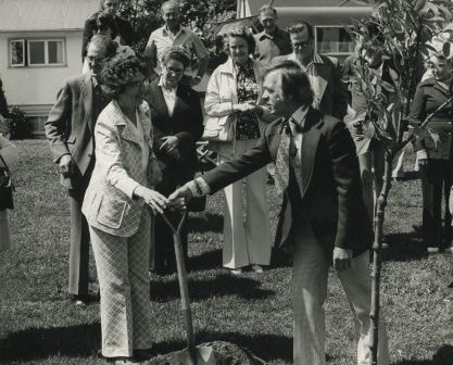
Eastburn Park tree planting
https://search.heritageburnaby.ca/link/archivedescription38626
- Repository
- City of Burnaby Archives
- Date
- June 8, 1976
- Collection/Fonds
- Burnaby Historical Society fonds
- Description Level
- Item
- Physical Description
- 1 photograph : b&w ; 20.5 x 25.5 cm pasted on cardboard backing
- Scope and Content
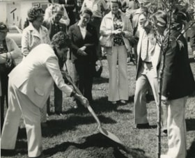
- Photograph of Jessie Beattie and Burnaby Mayor Tom Constable shoveling dirt onto a tree at a tree planting ceremony at Eastburn Park. Also identified in the photograph is Susan Dunn, who can be seen standing to the far left.
- Repository
- City of Burnaby Archives
- Date
- June 8, 1976
- Collection/Fonds
- Burnaby Historical Society fonds
- Subseries
- Municipal record subseries
- Physical Description
- 1 photograph : b&w ; 20.5 x 25.5 cm pasted on cardboard backing
- Description Level
- Item
- Record No.
- 467-002
- Access Restriction
- No restrictions
- Reproduction Restriction
- No restrictions
- Accession Number
- BHS2004-5
- Scope and Content
- Photograph of Jessie Beattie and Burnaby Mayor Tom Constable shoveling dirt onto a tree at a tree planting ceremony at Eastburn Park. Also identified in the photograph is Susan Dunn, who can be seen standing to the far left.
- Subjects
- Ceremonies
- Officials - Alderman and Councillors
- Officials - Mayors and Reeves
- Geographic Features - Parks
- Media Type
- Photograph
- Notes
- Title based on contents of photograph
- Geographic Access
- Eastburn Park
- 13th Avenue
- Street Address
- 7944 13th Avenue
- Historic Neighbourhood
- East Burnaby (Historic Neighbourhood)
- Planning Study Area
- Second Street Area
Images
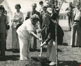
Eastburn Park tree planting
https://search.heritageburnaby.ca/link/archivedescription38627
- Repository
- City of Burnaby Archives
- Date
- June 8, 1976
- Collection/Fonds
- Burnaby Historical Society fonds
- Description Level
- Item
- Physical Description
- 1 photograph : b&w ; 20.5 x 25.5 cm pasted on cardboard backing.
- Scope and Content
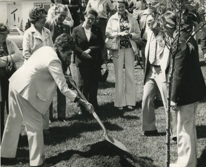
- Photograph of Jessie Beattie holding the shovel during the ceremonial tree planting at Eastburn Park. Burnaby Mayor Tom Constable is standing next to her, reaching for the shovel while Burnaby Council member Gerry Ast is visible to the far right (wearing light coloured suit). Standing in the crow…
- Repository
- City of Burnaby Archives
- Date
- June 8, 1976
- Collection/Fonds
- Burnaby Historical Society fonds
- Subseries
- Municipal record subseries
- Physical Description
- 1 photograph : b&w ; 20.5 x 25.5 cm pasted on cardboard backing.
- Description Level
- Item
- Record No.
- 467-003
- Access Restriction
- No restrictions
- Reproduction Restriction
- No restrictions
- Accession Number
- BHS2004-5
- Scope and Content
- Photograph of Jessie Beattie holding the shovel during the ceremonial tree planting at Eastburn Park. Burnaby Mayor Tom Constable is standing next to her, reaching for the shovel while Burnaby Council member Gerry Ast is visible to the far right (wearing light coloured suit). Standing in the crowd, behind Jessie and wearing a light coloured jacket is Ethel Widmen. The remainder of the people are unidentified.
- Subjects
- Ceremonies
- Officials - Alderman and Councillors
- Officials - Mayors and Reeves
- Geographic Features - Parks
- Media Type
- Photograph
- Notes
- Title based on contents of photograph
- Geographic Access
- Eastburn Park
- 13th Avenue
- Street Address
- 7944 13th Avenue
- Historic Neighbourhood
- East Burnaby (Historic Neighbourhood)
- Planning Study Area
- Second Street Area
Images

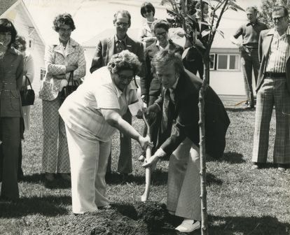
Eastburn Park tree planting ceremony
https://search.heritageburnaby.ca/link/archivedescription38628
- Repository
- City of Burnaby Archives
- Date
- June 8, 1976
- Collection/Fonds
- Burnaby Historical Society fonds
- Description Level
- Item
- Physical Description
- 1 photograph : b&w ; 20.5 x 25.5 cm pasted on cardboard backing
- Scope and Content
- Photograph of a woman shoveling dirt onto the base of a tree during the ceremonial tree planting at Eastburn Park. To the right of the photograph (turned away from the camera) is Burnaby Mayor Tom Constable and next to him (wearing light coloured suit) is Burnaby Council member Gerry Ast. In the …
- Repository
- City of Burnaby Archives
- Date
- June 8, 1976
- Collection/Fonds
- Burnaby Historical Society fonds
- Subseries
- Municipal record subseries
- Physical Description
- 1 photograph : b&w ; 20.5 x 25.5 cm pasted on cardboard backing
- Description Level
- Item
- Record No.
- 467-004
- Access Restriction
- No restrictions
- Reproduction Restriction
- No restrictions
- Accession Number
- BHS2004-5
- Scope and Content
- Photograph of a woman shoveling dirt onto the base of a tree during the ceremonial tree planting at Eastburn Park. To the right of the photograph (turned away from the camera) is Burnaby Mayor Tom Constable and next to him (wearing light coloured suit) is Burnaby Council member Gerry Ast. In the centre of the photograph (wearing light coloured jacket and holding a purse) is Ethel Widmen.
- Subjects
- Ceremonies
- Officials - Alderman and Councillors
- Officials - Mayors and Reeves
- Geographic Features - Parks
- Media Type
- Photograph
- Notes
- Title based on contents of photograph
- Geographic Access
- Eastburn Park
- 13th Avenue
- Street Address
- 7944 13th Avenue
- Historic Neighbourhood
- East Burnaby (Historic Neighbourhood)
- Planning Study Area
- Second Street Area
Images
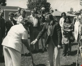
Eastburn Park tree planting ceremony
https://search.heritageburnaby.ca/link/archivedescription38629
- Repository
- City of Burnaby Archives
- Date
- June 8, 1976
- Collection/Fonds
- Burnaby Historical Society fonds
- Description Level
- Item
- Physical Description
- 1 photograph : b&w ; 20.5 x 25.5 cm pasted on cardboard backing
- Scope and Content
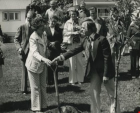
- Photograph of Burnaby Mayor Tom Constable handing a shovel to Robin Sanders as part of the tree planting ceremony at Eastburn Park. Standing behind them, wearing a light coloured jacket is Ethel Widmen.
- Repository
- City of Burnaby Archives
- Date
- June 8, 1976
- Collection/Fonds
- Burnaby Historical Society fonds
- Subseries
- Municipal record subseries
- Physical Description
- 1 photograph : b&w ; 20.5 x 25.5 cm pasted on cardboard backing
- Description Level
- Item
- Record No.
- 467-005
- Access Restriction
- No restrictions
- Reproduction Restriction
- No restrictions
- Accession Number
- BHS2004-5
- Scope and Content
- Photograph of Burnaby Mayor Tom Constable handing a shovel to Robin Sanders as part of the tree planting ceremony at Eastburn Park. Standing behind them, wearing a light coloured jacket is Ethel Widmen.
- Subjects
- Ceremonies
- Officials - Alderman and Councillors
- Officials - Mayors and Reeves
- Geographic Features - Parks
- Media Type
- Photograph
- Notes
- Title based on contents of photograph
- Geographic Access
- Eastburn Park
- 13th Avenue
- Street Address
- 7944 13th Avenue
- Historic Neighbourhood
- East Burnaby (Historic Neighbourhood)
- Planning Study Area
- Second Street Area
Images