More like 'Burnaby's COVID-19 drive thru testing site'
Narrow Results By

Crossing Royal Oak & Rumble Street
https://search.heritageburnaby.ca/link/archivedescription93686
- Repository
- City of Burnaby Archives
- Date
- May 19, 1978
- Collection/Fonds
- Burnaby Public Library Contemporary Visual Archive Project
- Description Level
- Item
- Physical Description
- 1 photograph : b&w ; 12.5 x 17.5 cm
- Scope and Content
- Photograph of the intersection of Royal Oak Avenue and Rumble Street. Cars and pedestrians are crossing the intersection, and the signs for businesses TD Bank, Standard Oil/Chevron gas station, Gulf gas station, and Baxter's Market are visible. The photograph is taken from a corner of the intersect…
- Repository
- City of Burnaby Archives
- Date
- May 19, 1978
- Collection/Fonds
- Burnaby Public Library Contemporary Visual Archive Project
- Physical Description
- 1 photograph : b&w ; 12.5 x 17.5 cm
- Description Level
- Item
- Record No.
- 556-643
- Access Restriction
- No restrictions
- Reproduction Restriction
- Reproduce for fair dealing purposes only
- Accession Number
- 2017-57
- Scope and Content
- Photograph of the intersection of Royal Oak Avenue and Rumble Street. Cars and pedestrians are crossing the intersection, and the signs for businesses TD Bank, Standard Oil/Chevron gas station, Gulf gas station, and Baxter's Market are visible. The photograph is taken from a corner of the intersection, facing southeast.
- Subjects
- Geographic Features - Roads
- Advertising Medium - Signs and Signboards
- Buildings - Commercial - Service Stations
- Transportation - Automobiles
- Buildings - Commercial
- Media Type
- Photograph
- Photographer
- van Mannen, Mark
- Notes
- Title taken from project information form
- Accompanied by a project information form and 1 photograph (b&w negative ; 9.5 x 12.5 cm)
- BPL no. 91
- Geographic Access
- Royal Oak Avenue
- Rumble Street
- Historic Neighbourhood
- Alta Vista (Historic Neighbourhood)
- Planning Study Area
- Sussex-Nelson Area
Images


Crossing Royal Oak & Rumble Street
https://search.heritageburnaby.ca/link/archivedescription93687
- Repository
- City of Burnaby Archives
- Date
- May 19, 1978
- Collection/Fonds
- Burnaby Public Library Contemporary Visual Archive Project
- Description Level
- Item
- Physical Description
- 1 photograph : b&w ; 12.5 x 17.5 cm
- Scope and Content
- Photograph of the intersection of Royal Oak Avenue and Rumble Street. Cars and pedestrians are crossing the intersection, and the signs for businesses Grace United Pharmacy, Standard Oil/Chevron gas station, Gulf gas station, and Royal Meats are visible. The photograph is taken from the Gulf gas st…
- Repository
- City of Burnaby Archives
- Date
- May 19, 1978
- Collection/Fonds
- Burnaby Public Library Contemporary Visual Archive Project
- Physical Description
- 1 photograph : b&w ; 12.5 x 17.5 cm
- Description Level
- Item
- Record No.
- 556-644
- Access Restriction
- No restrictions
- Reproduction Restriction
- Reproduce for fair dealing purposes only
- Accession Number
- 2017-57
- Scope and Content
- Photograph of the intersection of Royal Oak Avenue and Rumble Street. Cars and pedestrians are crossing the intersection, and the signs for businesses Grace United Pharmacy, Standard Oil/Chevron gas station, Gulf gas station, and Royal Meats are visible. The photograph is taken from the Gulf gas station parking lot, facing northwest.
- Subjects
- Advertising Medium - Signs and Signboards
- Geographic Features - Roads
- Transportation - Automobiles
- Buildings - Commercial
- Buildings - Commercial - Service Stations
- Media Type
- Photograph
- Photographer
- van Mannen, Mark
- Notes
- Title taken from project information form
- Accompanied by a project information form and 1 photograph (b&w negative ; 9.5 x 12.5 cm)
- BPL no. 92
- Geographic Access
- Royal Oak Avenue
- Rumble Street
- Historic Neighbourhood
- Alta Vista (Historic Neighbourhood)
- Planning Study Area
- Sussex-Nelson Area
Images

![Highway Improvement Project signage, [1972] thumbnail](/media/hpo/_Data/_Archives_Images/_Unrestricted/480/480-280.jpg?width=280)
Highway Improvement Project signage
https://search.heritageburnaby.ca/link/archivedescription45385
- Repository
- City of Burnaby Archives
- Date
- [1972]
- Collection/Fonds
- Columbian Newspaper collection
- Description Level
- Item
- Physical Description
- 1 photograph : b&w ; 14 x 21 cm
- Scope and Content
- Photograph of Highway Improvement Project signage (developed by the British Columbian Government under W.A.C. Bennett) along the Trans Canada Highway.
- Repository
- City of Burnaby Archives
- Date
- [1972]
- Collection/Fonds
- Columbian Newspaper collection
- Physical Description
- 1 photograph : b&w ; 14 x 21 cm
- Description Level
- Item
- Record No.
- 480-280
- Access Restriction
- No restrictions
- Reproduction Restriction
- No restrictions
- Accession Number
- 2003-02
- Scope and Content
- Photograph of Highway Improvement Project signage (developed by the British Columbian Government under W.A.C. Bennett) along the Trans Canada Highway.
- Media Type
- Photograph
- Photographer
- King, Basil
- Notes
- Title based on contents of photograph
Images
![Highway Improvement Project signage, [1972] thumbnail](/media/hpo/_Data/_Archives_Images/_Unrestricted/480/480-280.jpg)
Interview with Basil Luksun and Jack Belhouse by Kathy Bossort November 24, 2015 - Track 3
https://search.heritageburnaby.ca/link/oralhistory629
- Repository
- City of Burnaby Archives
- Date Range
- 1970-1990
- Length
- 0:15:10
- Summary
- This portion of the interview is about Basil Luksun and Jack Belhouse talking about the background to the creation of their 1974 report “The Public Meetings - Phase One” which made recommendations for long range planning policies for the City of Burnaby, including the creation of the conservation a…
- Repository
- City of Burnaby Archives
- Summary
- This portion of the interview is about Basil Luksun and Jack Belhouse talking about the background to the creation of their 1974 report “The Public Meetings - Phase One” which made recommendations for long range planning policies for the City of Burnaby, including the creation of the conservation area on Burnaby Mountain. They talk about meeting with the public as a strategy for refreshing policy, the shift in public attitudes for saving green spaces, and the City’s strong policy base for making decisions.
- Date Range
- 1970-1990
- Length
- 0:15:10
- Geographic Access
- Burnaby Mountain Conservation Area
- Interviewer
- Bossort, Kathy
- Interview Date
- November 24, 2015
- Scope and Content
- Recording is of an interview with Basil Luksun and Jack Belhouse conducted by Kathy Bossort. Basil Luksun and Jack Belhouse were two of 23 participants interviewed as part of the Community Heritage Commission’s Burnaby Mountain Oral History Project. The interview is mainly about the history of setting aside parkland by dedication on Burnaby Mountain, the 1974/76 delineation of the conservation area on Burnaby Mountain, and the dispute between Burnaby and Simon Fraser University over land ownership and control on Burnaby Mountain, as discussed by two retired participants in these events from the City of Burnaby’s Planning and Building Department, Basil Luksun and Jack Belhouse. They also talk about their interaction with the public in developing policies, particularly for the 1974 report “The Public Meetings - Phase One”, and the importance of a strong policy base for long range planning and the patience needed to assemble land for large parks. They talk as well about their careers, their close working relationship in the department, and the cooperation between City and SFU staff in the development of UniverCity.
- Biographical Notes
- Basil Luksun was born and educated in South Africa, immigrating to Canada and Burnaby in 1972 to escape the harmful effects of apartheid. He holds a BSc degree from the University of Cape Town and a Post-Graduate Diploma in Town Planning from the University of Witwatersrand. He joined the City of Burnaby’s Planning and Building Department in 1973, working his way up through the organization to Director of the department before retiring after 39 years in 2012. When he started work in the 1970s, the City of Burnaby was focusing on green space planning projects and he takes great pride in these projects as well as the city’s focus on long-term planning. Basil lived in the Capital Hill area from 1972 to 1990. He currently resides in Vancouver and has two sons, Warren and Derek. Jack Belhouse was born in 1946 in Vancouver and attended UBC, York University and SFU (1965-1972), majoring in urban geography. He began working in Burnaby’s planning department as a summer student in 1968, and was offered a full-time position when he graduated from university. He became Director of the Planning and Building Department before retiring after 38 years with the city in 2006. He and Basil Luksun worked closely together in long range planning in the department. Jack lives in Coquitlam with his wife Linda and has two children, Brad and Lori.
- Total Tracks
- 8
- Total Length
- 1:58:23
- Interviewee Name
- Luksun, Basil
- Belhouse, Jack
- Interview Location
- Basil Luksun's home in Vancouver
- Interviewer Bio
- Kathy Bossort is a retired archivist living in Ladner, BC. She worked at the Delta Museum and Archives after graduating from SLAIS (UBC) in 2001 with Masters degrees in library science and archival studies. Kathy grew up in Calgary, Alberta, and, prior to this career change, she lived in the West Kootenays, earning her living as a cook for BC tourist lodges and work camps. She continues to be interested in oral histories as a way to fill the gaps in the written record and bring richer meaning to history.
- Collection/Fonds
- Community Heritage Commission Special Projects fonds
- Media Type
- Sound Recording
Audio Tracks
Track three of interview with Basil Luksun and Jack Belhouse
Track three of interview with Basil Luksun and Jack Belhouse
https://search.heritageburnaby.ca/media/hpo/_Data/_Archives_Oral_Histories/_Unrestricted/MSS196-012/MSS196-012_Track_3.mp3
Interview with Sev Morin by Rod Fowler April 4, 1990 - Track 10
https://search.heritageburnaby.ca/link/oralhistory546
- Repository
- City of Burnaby Archives
- Date Range
- 1950-1990
- Length
- 00:09:22
- Summary
- This portion of the interview is about Sev Morin’s views about Burnaby’s identity and the irrelevance of municipal boundary lines for many functions; his identification of Burnaby’s heritage, ecological and educational “gems”; and musings about the next development phases for Burnaby
- Repository
- City of Burnaby Archives
- Summary
- This portion of the interview is about Sev Morin’s views about Burnaby’s identity and the irrelevance of municipal boundary lines for many functions; his identification of Burnaby’s heritage, ecological and educational “gems”; and musings about the next development phases for Burnaby
- Date Range
- 1950-1990
- Photo Info
- Sev Morin (left) of Severin's in Burnaby (formerly the Gai Paree) hosting a gala New Year's celebration, 1979. Item no. 480-712
- Length
- 00:09:22
- Subjects
- Public Services - Municipal Services
- Planning
- Industries
- Geographic Features - Parks
- Buildings - Recreational
- Interviewer
- Fowler, Rod
- Interview Date
- April 4, 1990
- Scope and Content
- Recording is of an interview with Severin "Sev" Morin, conducted by Rod Fowler. Sev Morin was one of eleven participants interviewed as part of the SFU/Burnaby Centennial Committee's oral history series titled, "Voices of Burnaby". The interview is mainly about Sev Morin’s banquet hall, restaurant and night club business on Kingsway, originally named the “Gai Paree Supper Club” (1947-1976) and later “Severin’s” (1976-1985) and “Diego’s” (1985-1994), its function as a Burnaby landmark, and the entertainment and political people he met through his business. He also describes his many volunteer activities in Burnaby, including member of the SFU Senate, Rotary Club, Variety Club and Telethon, fund raising for Burnaby Hospital, and tourism related groups, and his political work for the federal Liberal party. He talks about his parents’ origins, the lives of his brothers Rudy and Rene, and the family’s involvement in establishing the “Gai Paree”. He also shares his views about the business and cultural development of Burnaby. To view “Narrow By” terms for each track expand this description and see “Notes”.
- Biographical Notes
- Severin “Sev” Rene Morin was born September 21, 1927, in Bonneville, Alberta, to Rene Pierre Morin (1878-1963) and Anne Marie (nee Lachiver) Morin (1886-1956). Mr. and Mrs. R. P. Morin and their son Rene Francois (1905-1954) immigrated to Edmonton, Alberta, from France in 1913, where Rene Pierre Morin worked for the C.N.R. and a second son Adolphe “Rudy” Ferdinand (1922-1969) was born, followed by their third son Severin. In 1943, after R.P. Morin retired, the family moved to Burnaby to a house on Sperling Avenue. Sometime earlier the two older Morin brothers found work in Trail at the smelter and developed musical careers. In 1946/47 the Morin family purchased property on Kingsway and built a banquet hall, the “Gai Paree Supper Club”. Sev and Rudy Morin managed the club and Rene F. Morin moved to Burnaby to join them with his band. The supper club, with its live music and dance floor, became a popular meeting place and wedding venue, eventually expanding into a restaurant and nightclub in the 1970s. The “Gai Paree” was renamed “Severin’s” in 1976 and “Diego’s” in 1985, closing finally in 1994. Sev Morin’s business life included three record stores which he owned with his friend Jack Cullen. Through these businesses Sev Morin was well known in the entertainment and hospitality industry. He and his restaurant also hosted political and social events that made the restaurant a community landmark. Sev Morin contributed many volunteer hours to community and charitable organizations, including an appointment to the SFU Senate, fundraising for the Burnaby Hospital, Director of the Variety Club and Rotary Club, and consultant for a variety of tourism related ventures. He also was active in the federal Liberal Party. Sev Morin and his wife Pauline married in 1950 and had three children. Sev Morin died at age 86 on March 28, 2014.
- Total Tracks
- 10
- Total Length
- 00:56:44
- Interviewee Name
- Morin, Severin "Sev"
- Interviewer Bio
- Rod Fowler returned to university as a mature student in the 1980s after working about twenty years in the field of economics and computerization in business in England, Europe and Western Canada. He graduated with a BA from SFU in both History and Sociology in 1987, his MA degree in Geography in 1989, and his PhD in Cultural Geography at SFU. He taught courses in Geography, Sociology, History and Canadian Studies at several Lower Mainland colleges, before becoming a full time member of the Geography Department at Kwantlen University College.
- Collection/Fonds
- SFU/Burnaby Centennial Committee fonds
- Transcript Available
- Transcript available
- Media Type
- Sound Recording
- Web Notes
- Interviews were digitized in 2015 allowing them to be accessible on Heritage Burnaby. The digitization project was initiated by the Community Heritage Commission with support from City of Burnaby Council.
Images

Audio Tracks
Track ten of interview with Sev Morin
Track ten of interview with Sev Morin
https://search.heritageburnaby.ca/media/hpo/_Data/_Archives_Oral_Histories/_Unrestricted/MSS187-021/MSS187-021_Track%2010.mp3
123 Cinema sign
https://search.heritageburnaby.ca/link/archivedescription46283
- Repository
- City of Burnaby Archives
- Date
- November 15, 1979
- Collection/Fonds
- Columbian Newspaper collection
- Description Level
- Item
- Physical Description
- 1 photograph : b&w ; 24 x 9.5 cm
- Scope and Content
- Photograph of the 123 Cinema sign at Lougheed Mall which reads; "VOTE NOV 17 / DAVE MERCIER BVA / MAYOR".
- Repository
- City of Burnaby Archives
- Date
- November 15, 1979
- Collection/Fonds
- Columbian Newspaper collection
- Physical Description
- 1 photograph : b&w ; 24 x 9.5 cm
- Description Level
- Item
- Record No.
- 480-1171
- Access Restriction
- No restrictions
- Reproduction Restriction
- Reproduce for fair dealing purposes only
- Accession Number
- 2003-02
- Scope and Content
- Photograph of the 123 Cinema sign at Lougheed Mall which reads; "VOTE NOV 17 / DAVE MERCIER BVA / MAYOR".
- Names
- Lougheed Town Centre
- Media Type
- Photograph
- Photographer
- Hodge, Craig
- Notes
- Title based on contents of photograph
- Newspaper clipping attached to verso of photograph reads: "Now showing: Strong support for Mercier."
- Geographic Access
- Austin Road
- Historic Neighbourhood
- Burquitlam (Historic Neighbourhood)
- Planning Study Area
- Cameron Area
Images


5486 Dominion Street
https://search.heritageburnaby.ca/link/archivedescription91871
- Repository
- City of Burnaby Archives
- Date
- 1971
- Collection/Fonds
- Small family fonds
- Description Level
- Item
- Physical Description
- 1 photograph : b&w ; 9 cm x 9 cm
- Scope and Content
- Photograph of the Small family's house at 5486 Dominion Street with a "For Sale" sign on the lawn. The house was put up for sale by Lauretta Small after she inherited the Roberts' house at 5538 Dominion Street in 1969. Lauretta, by then a widow, relocated back into the Roberts' house which was th…
- Repository
- City of Burnaby Archives
- Date
- 1971
- Collection/Fonds
- Small family fonds
- Physical Description
- 1 photograph : b&w ; 9 cm x 9 cm
- Description Level
- Item
- Record No.
- 620-052
- Access Restriction
- No restrictions
- Reproduction Restriction
- No reproduction permitted
- Accession Number
- 2017-01
- Scope and Content
- Photograph of the Small family's house at 5486 Dominion Street with a "For Sale" sign on the lawn. The house was put up for sale by Lauretta Small after she inherited the Roberts' house at 5538 Dominion Street in 1969. Lauretta, by then a widow, relocated back into the Roberts' house which was the house she grew up in as a child.
- Media Type
- Photograph
- Notes
- Transcribed title
- Title transcribed from donor's notes
- Note in blue ink on verso of photograph reads: "P.14"
- Note in blue ink on verso of photograph reads: "5486 Dominion St / Burnaby, B.C. / Fall '71"
- 5486 Dominion Street later subdivided into two lots: 5480 and 5488 Dominion Street
- Street Address
- 5486 Dominion Street
- Historic Neighbourhood
- Burnaby Lake (Historic Neighbourhood)
- Planning Study Area
- Ardingley-Sprott Area
Images


A & Aero Trading Salvage
https://search.heritageburnaby.ca/link/archivedescription79166
- Repository
- City of Burnaby Archives
- Date
- October 16, 1976
- Collection/Fonds
- Burnaby Public Library Contemporary Visual Archive Project
- Description Level
- Item
- Physical Description
- 1 photograph : b&w ; 11 x 16 cm mounted on cardboard
- Scope and Content
- Photograph shows a large sign advertising lawn mower sharpening over A & Aero Trading Salvage at 6147 Hastings Street.
- Repository
- City of Burnaby Archives
- Date
- October 16, 1976
- Collection/Fonds
- Burnaby Public Library Contemporary Visual Archive Project
- Physical Description
- 1 photograph : b&w ; 11 x 16 cm mounted on cardboard
- Description Level
- Item
- Record No.
- 556-184
- Access Restriction
- No restrictions
- Reproduction Restriction
- Reproduce for fair dealing purposes only
- Accession Number
- 2013-13
- Scope and Content
- Photograph shows a large sign advertising lawn mower sharpening over A & Aero Trading Salvage at 6147 Hastings Street.
- Names
- A & Aero Trading Salvage
- Media Type
- Photograph
- Notes
- Scope note taken directly from BPL photograph description.
- 1 b&w copy negative : 10 x 12.5 cm accompanying
- Photographers identified by surnames only: Carr and Vardeman
- Geographic Access
- Hastings Street
- Street Address
- 6147 Hastings Street
- Historic Neighbourhood
- Lochdale (Historic Neighbourhood)
- Planning Study Area
- Westridge Area
Images


Admiral Hotel
https://search.heritageburnaby.ca/link/archivedescription93660
- Repository
- City of Burnaby Archives
- Date
- November 13, 1977
- Collection/Fonds
- Burnaby Public Library Contemporary Visual Archive Project
- Description Level
- Item
- Physical Description
- 1 photograph : b&w ; 12.5 x 17.5 cm
- Scope and Content
- Photograph of the front exterior of the Admiral Hotel, located on the 4100 block of Hastings Street. The photograph is taken from across the street, facing northwest, and shows the mural on the front of the hotel and the hotel's sign.
- Repository
- City of Burnaby Archives
- Date
- November 13, 1977
- Collection/Fonds
- Burnaby Public Library Contemporary Visual Archive Project
- Physical Description
- 1 photograph : b&w ; 12.5 x 17.5 cm
- Description Level
- Item
- Record No.
- 556-617
- Access Restriction
- No restrictions
- Reproduction Restriction
- Reproduce for fair dealing purposes only
- Accession Number
- 2017-57
- Scope and Content
- Photograph of the front exterior of the Admiral Hotel, located on the 4100 block of Hastings Street. The photograph is taken from across the street, facing northwest, and shows the mural on the front of the hotel and the hotel's sign.
- Names
- Admiral Hotel
- Media Type
- Photograph
- Photographer
- Chapman, Fred
- Notes
- Title taken from project information form
- Accompanied by a project information form and 1 photograph (b&w negative ; 9.5 x 12.5 cm)
- BPL no. 67
- Geographic Access
- Hastings Street
- Street Address
- 4125 Hastings Street
- Historic Neighbourhood
- Vancouver Heights (Historic Neighbourhood)
- Planning Study Area
- Burnaby Heights Area
Images


Advertising adjacent Jan's Grocery Store
https://search.heritageburnaby.ca/link/archivedescription79082
- Repository
- City of Burnaby Archives
- Date
- October, 1976
- Collection/Fonds
- Burnaby Public Library Contemporary Visual Archive Project
- Description Level
- Item
- Physical Description
- 1 photograph : b&w ; 11 x 16 cm mounted on cardboard
- Scope and Content
- Photograph shows large billboard advertising the PNE, beside Jan's Grocery store located at 4759 Hastings Street.
- Repository
- City of Burnaby Archives
- Date
- October, 1976
- Collection/Fonds
- Burnaby Public Library Contemporary Visual Archive Project
- Physical Description
- 1 photograph : b&w ; 11 x 16 cm mounted on cardboard
- Description Level
- Item
- Record No.
- 556-141
- Access Restriction
- No restrictions
- Reproduction Restriction
- Reproduce for fair dealing purposes only
- Accession Number
- 2013-13
- Scope and Content
- Photograph shows large billboard advertising the PNE, beside Jan's Grocery store located at 4759 Hastings Street.
- Media Type
- Photograph
- Photographer
- Cook, Alan
- Notes
- Scope note taken directly from BPL photograph description.
- 1 b&w copy negative : 10 x 12.5 cm accompanying
- Geographic Access
- Hastings Street
- Street Address
- 4759 Hastings Street
- Historic Neighbourhood
- Capitol Hill (Historic Neighbourhood)
- Planning Study Area
- Capitol Hill Area
Images


Advertising Medium - Signs and Signboards Circus Posters
https://search.heritageburnaby.ca/link/archivedescription79711
- Repository
- City of Burnaby Archives
- Date
- September 20, 1976
- Collection/Fonds
- Burnaby Public Library Contemporary Visual Archive Project
- Description Level
- Item
- Physical Description
- 1 photograph : b&w ; 11 x 16 cm mounted on cardboard
- Scope and Content
- Photograph shows circus posters on a tree in the 6200 Block of Hastings Street.
- Repository
- City of Burnaby Archives
- Date
- September 20, 1976
- Collection/Fonds
- Burnaby Public Library Contemporary Visual Archive Project
- Physical Description
- 1 photograph : b&w ; 11 x 16 cm mounted on cardboard
- Description Level
- Item
- Record No.
- 556-395
- Access Restriction
- No restrictions
- Reproduction Restriction
- Reproduce for fair dealing purposes only
- Accession Number
- 2013-13
- Scope and Content
- Photograph shows circus posters on a tree in the 6200 Block of Hastings Street.
- Media Type
- Photograph
- Photographer
- Born, A. J.
- Notes
- Scope note taken directly from BPL photograph description.
- 1 b&w copy negative : 10 x 12.5 cm accompanying
- Geographic Access
- Hastings Street
- Planning Study Area
- Parkcrest-Aubrey Area
Images


Advertising Signs
https://search.heritageburnaby.ca/link/archivedescription79154
- Repository
- City of Burnaby Archives
- Date
- November 1, 1976
- Collection/Fonds
- Burnaby Public Library Contemporary Visual Archive Project
- Description Level
- Item
- Physical Description
- 1 photograph : b&w ; 11 x 16 cm mounted on cardboard
- Scope and Content
- Photograph shows signs advertising Musgrove Ford Ltd. and Burnaby Cleaners on top of the building which housed Burnaby Cleaners at 4429 Hastings Street.
- Repository
- City of Burnaby Archives
- Date
- November 1, 1976
- Collection/Fonds
- Burnaby Public Library Contemporary Visual Archive Project
- Physical Description
- 1 photograph : b&w ; 11 x 16 cm mounted on cardboard
- Description Level
- Item
- Record No.
- 556-178
- Access Restriction
- No restrictions
- Reproduction Restriction
- Reproduce for fair dealing purposes only
- Accession Number
- 2013-13
- Scope and Content
- Photograph shows signs advertising Musgrove Ford Ltd. and Burnaby Cleaners on top of the building which housed Burnaby Cleaners at 4429 Hastings Street.
- Names
- Burnaby Cleaners
- Media Type
- Photograph
- Notes
- Scope note taken directly from BPL photograph description.
- 1 b&w copy negative : 10 x 12.5 cm accompanying
- Photographers identified by surnames only: Carr and Vardeman
- Geographic Access
- Hastings Street
- Street Address
- 4429 Hastings Street
- Historic Neighbourhood
- Vancouver Heights (Historic Neighbourhood)
- Planning Study Area
- Burnaby Heights Area
Images


Apartment at Albert and Ingleton
https://search.heritageburnaby.ca/link/archivedescription79031
- Repository
- City of Burnaby Archives
- Date
- September 12, 1976
- Collection/Fonds
- Burnaby Public Library Contemporary Visual Archive Project
- Description Level
- Item
- Physical Description
- 1 photograph : b&w ; 11 x 16 cm mounted on cardboard
- Scope and Content
- Photograph shows a sign on an apartment building on Albert Street near Ingleton Avenue.
- Repository
- City of Burnaby Archives
- Date
- September 12, 1976
- Collection/Fonds
- Burnaby Public Library Contemporary Visual Archive Project
- Physical Description
- 1 photograph : b&w ; 11 x 16 cm mounted on cardboard
- Description Level
- Item
- Record No.
- 556-102
- Access Restriction
- No restrictions
- Reproduction Restriction
- Reproduce for fair dealing purposes only
- Accession Number
- 2013-13
- Scope and Content
- Photograph shows a sign on an apartment building on Albert Street near Ingleton Avenue.
- Media Type
- Photograph
- Notes
- Scope note taken directly from BPL photograph description.
- 1 b&w copy negative : 10 x 12.5 cm accompanying
- Photographers identified by surnames only: Carr and Vardeman
- Geographic Access
- Albert Street
- Ingleton Avenue
- Historic Neighbourhood
- Vancouver Heights (Historic Neighbourhood)
- Planning Study Area
- Burnaby Heights Area
Images


Astor Hotel
https://search.heritageburnaby.ca/link/archivedescription93657
- Repository
- City of Burnaby Archives
- Date
- November 13, 1977
- Collection/Fonds
- Burnaby Public Library Contemporary Visual Archive Project
- Description Level
- Item
- Physical Description
- 1 photograph : b&w ; 12.5 x 17.5 cm
- Scope and Content
- Photograph of the exterior of the Astor Motor Hotel and its hotel sign, located on the 4500 block of Kingsway. The photograph is taken facing northeast.
- Repository
- City of Burnaby Archives
- Date
- November 13, 1977
- Collection/Fonds
- Burnaby Public Library Contemporary Visual Archive Project
- Physical Description
- 1 photograph : b&w ; 12.5 x 17.5 cm
- Description Level
- Item
- Record No.
- 556-614
- Access Restriction
- No restrictions
- Reproduction Restriction
- Reproduce for fair dealing purposes only
- Accession Number
- 2017-57
- Scope and Content
- Photograph of the exterior of the Astor Motor Hotel and its hotel sign, located on the 4500 block of Kingsway. The photograph is taken facing northeast.
- Names
- Astor Hotel
- Media Type
- Photograph
- Photographer
- Chapman, Fred
- Notes
- Title taken from project information form
- Accompanied by a project information form and 1 photograph (b&w negative ; 9.5 x 12.5 cm)
- BPL no. 64
- Geographic Access
- Kingsway
- Street Address
- 4561 Kingsway
- Historic Neighbourhood
- Central Park (Historic Neighbourhood)
- Planning Study Area
- Marlborough Area
Images


Astor Motor Hotel
https://search.heritageburnaby.ca/link/archivedescription79333
- Repository
- City of Burnaby Archives
- Date
- November 1, 1976
- Collection/Fonds
- Burnaby Public Library Contemporary Visual Archive Project
- Description Level
- Item
- Physical Description
- 1 photograph : b&w ; 11 x 16 cm mounted on cardboard
- Scope and Content
- Photograph shows the Astor Motor Hotel at 4561 Kingsway. Its prominent sign describes its facilities and directs people to the parking lot in the rear.
- Repository
- City of Burnaby Archives
- Date
- November 1, 1976
- Collection/Fonds
- Burnaby Public Library Contemporary Visual Archive Project
- Physical Description
- 1 photograph : b&w ; 11 x 16 cm mounted on cardboard
- Description Level
- Item
- Record No.
- 556-247
- Access Restriction
- No restrictions
- Reproduction Restriction
- Reproduce for fair dealing purposes only
- Accession Number
- 2013-13
- Scope and Content
- Photograph shows the Astor Motor Hotel at 4561 Kingsway. Its prominent sign describes its facilities and directs people to the parking lot in the rear.
- Names
- Astor Hotel
- Media Type
- Photograph
- Notes
- Scope note taken directly from BPL photograph description.
- 1 b&w copy negative : 10 x 12.5 cm accompanying
- Photographers identified by surnames only: Carr and Vardeman
- Geographic Access
- Kingsway
- Street Address
- 4561 Kingsway
- Historic Neighbourhood
- Central Park (Historic Neighbourhood)
- Planning Study Area
- Marlborough Area
Images


BCGEU Protestors
https://search.heritageburnaby.ca/link/archivedescription79500
- Repository
- City of Burnaby Archives
- Date
- October 14, 1976
- Collection/Fonds
- Burnaby Public Library Contemporary Visual Archive Project
- Description Level
- Item
- Physical Description
- 1 photograph : b&w ; 11 x 16 cm mounted on cardboard
- Scope and Content
- Photograph shows two members of the BC Government Employees Union, holding a large sign protesting wage and price controls outside the gates of the Lower Mainland Regional Correctional Centre at 5700 Royal Oak Avenue (later 5220 Oakmount Crescent).
- Repository
- City of Burnaby Archives
- Date
- October 14, 1976
- Collection/Fonds
- Burnaby Public Library Contemporary Visual Archive Project
- Physical Description
- 1 photograph : b&w ; 11 x 16 cm mounted on cardboard
- Description Level
- Item
- Record No.
- 556-329
- Access Restriction
- No restrictions
- Reproduction Restriction
- Reproduce for fair dealing purposes only
- Accession Number
- 2013-13
- Scope and Content
- Photograph shows two members of the BC Government Employees Union, holding a large sign protesting wage and price controls outside the gates of the Lower Mainland Regional Correctional Centre at 5700 Royal Oak Avenue (later 5220 Oakmount Crescent).
- Media Type
- Photograph
- Photographer
- Norton, Paul
- Notes
- Scope note taken directly from BPL photograph description.
- 1 b&w copy negative : 10 x 12.5 cm accompanying
- Geographic Access
- Oakmount Crescent
- Street Address
- 5220 Oakmount Crescent
- 5700 Royal Oak Avenue
- Historic Neighbourhood
- Burnaby Lake (Historic Neighbourhood)
- Planning Study Area
- Oakalla Area
Images


BC Hydro Railway Crossing
https://search.heritageburnaby.ca/link/archivedescription79487
- Repository
- City of Burnaby Archives
- Date
- September 22, 1976
- Collection/Fonds
- Burnaby Public Library Contemporary Visual Archive Project
- Description Level
- Item
- Physical Description
- 1 photograph : b&w ; 11 x 16 cm mounted on cardboard
- Scope and Content
- Photograph shows BC Hydro railroad tracks and crossing near Beresford Street and Griffiths Avenue.
- Repository
- City of Burnaby Archives
- Date
- September 22, 1976
- Collection/Fonds
- Burnaby Public Library Contemporary Visual Archive Project
- Physical Description
- 1 photograph : b&w ; 11 x 16 cm mounted on cardboard
- Description Level
- Item
- Record No.
- 556-319
- Access Restriction
- No restrictions
- Reproduction Restriction
- Reproduce for fair dealing purposes only
- Accession Number
- 2013-13
- Scope and Content
- Photograph shows BC Hydro railroad tracks and crossing near Beresford Street and Griffiths Avenue.
- Media Type
- Photograph
- Photographer
- Ross, Martha
- Notes
- Scope note taken directly from BPL photograph description.
- 1 b&w copy negative : 10 x 12.5 cm accompanying
- Historic Neighbourhood
- Edmonds (Historic Neighbourhood)
- Planning Study Area
- Stride Avenue Area
Images

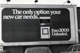
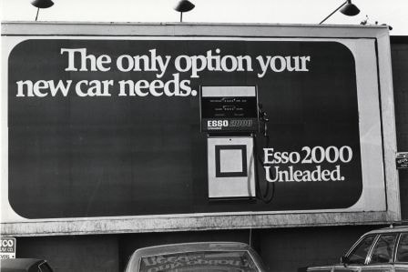
Billboard
https://search.heritageburnaby.ca/link/archivedescription79927
- Repository
- City of Burnaby Archives
- Date
- October 20, 1976
- Collection/Fonds
- Burnaby Public Library Contemporary Visual Archive Project
- Description Level
- Item
- Physical Description
- 1 photograph : b&w ; 11 x 16 cm mounted on cardboard
- Scope and Content
- Photograph shows a large billboard advertising Esso Gas in a parking lot off Edmonds, near Kingsway.
- Repository
- City of Burnaby Archives
- Date
- October 20, 1976
- Collection/Fonds
- Burnaby Public Library Contemporary Visual Archive Project
- Physical Description
- 1 photograph : b&w ; 11 x 16 cm mounted on cardboard
- Description Level
- Item
- Record No.
- 556-498
- Access Restriction
- No restrictions
- Reproduction Restriction
- Reproduce for fair dealing purposes only
- Accession Number
- 2013-13
- Scope and Content
- Photograph shows a large billboard advertising Esso Gas in a parking lot off Edmonds, near Kingsway.
- Media Type
- Photograph
- Photographer
- Ross, Martha
- Notes
- Scope note taken directly from BPL photograph description.
- 1 b&w copy negative : 10 x 12.5 cm accompanying
- Historic Neighbourhood
- Edmonds (Historic Neighbourhood)
Images
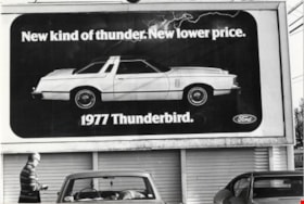
Billboard
https://search.heritageburnaby.ca/link/archivedescription79928
- Repository
- City of Burnaby Archives
- Date
- October 20, 1976
- Collection/Fonds
- Burnaby Public Library Contemporary Visual Archive Project
- Description Level
- Item
- Physical Description
- 1 photograph : b&w ; 11 x 16 cm mounted on cardboard
- Scope and Content
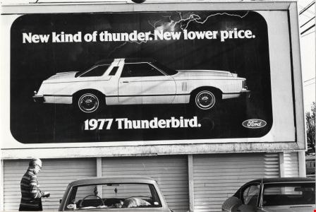
- Photograph shows a large billboard advertising the 1977 Thunderbird car. The sign is attached to the side of a building in a parking lot on Edmonds Street near Kingsway.
- Repository
- City of Burnaby Archives
- Date
- October 20, 1976
- Collection/Fonds
- Burnaby Public Library Contemporary Visual Archive Project
- Physical Description
- 1 photograph : b&w ; 11 x 16 cm mounted on cardboard
- Description Level
- Item
- Record No.
- 556-499
- Access Restriction
- No restrictions
- Reproduction Restriction
- Reproduce for fair dealing purposes only
- Accession Number
- 2013-13
- Scope and Content
- Photograph shows a large billboard advertising the 1977 Thunderbird car. The sign is attached to the side of a building in a parking lot on Edmonds Street near Kingsway.
- Media Type
- Photograph
- Photographer
- Ross, Martha
- Notes
- Scope note taken directly from BPL photograph description.
- 1 b&w copy negative : 10 x 12.5 cm accompanying
- Historic Neighbourhood
- Edmonds (Historic Neighbourhood)
Images
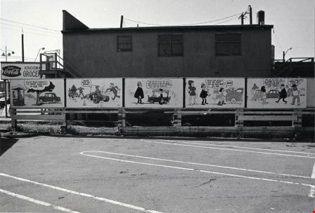
Billboards
https://search.heritageburnaby.ca/link/archivedescription79931
- Repository
- City of Burnaby Archives
- Date
- September 10, 1976
- Collection/Fonds
- Burnaby Public Library Contemporary Visual Archive Project
- Description Level
- Item
- Physical Description
- 1 photograph : b&w ; 11 x 16 cm mounted on cardboard
- Scope and Content
- Photograph shows humorous billboards advertising Kingsgate Auto Ltd. at 5775 Kingsway.
- Repository
- City of Burnaby Archives
- Date
- September 10, 1976
- Collection/Fonds
- Burnaby Public Library Contemporary Visual Archive Project
- Physical Description
- 1 photograph : b&w ; 11 x 16 cm mounted on cardboard
- Description Level
- Item
- Record No.
- 556-502
- Access Restriction
- No restrictions
- Reproduction Restriction
- Reproduce for fair dealing purposes only
- Accession Number
- 2013-13
- Scope and Content
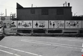
- Photograph shows humorous billboards advertising Kingsgate Auto Ltd. at 5775 Kingsway.
- Media Type
- Photograph
- Photographer
- Norton, Paul
- Notes
- Scope note taken directly from BPL photograph description.
- 1 b&w copy negative : 10 x 12.5 cm accompanying
- Geographic Access
- Kingsway
- Street Address
- 5775 Kingsway
- Planning Study Area
- Windsor Area
Images