More like 'Beach at Yellow Point'
Narrow Results By
Subject
- Advertising Medium - Signs and Signboards 3
- Aerial Photographs 2
- Animals 2
- Animals - Birds 5
- Arts - Paintings 5
- Buildings - Civic 3
- Buildings - Civic - City Halls 1
- Buildings - Commercial 3
- Buildings - Commercial - Restaurants 1
- Buildings - Commercial - Service Stations 3
- Buildings - Commercial - Stores 1
- Buildings - Heritage 1
Person / Organization
- Admiral Hotel 1
- Ast, Gerald D. 6
- Beattie, Jessie 3
- British Columbia Institute of Technology 1
- British Columbia Vocational School 1
- Burnaby City Hall 1
- Burnaby Lake Nature House 2
- Burnaby Lake Riding Academy 1
- Burnaby Lake Rowing Pavilion 1
- Burnaby Lake Saddle Club 1
- Burnaby Mountain Park 5
- Burnaby Village Museum 4

Barnet Beach
https://search.heritageburnaby.ca/link/archivedescription93650
- Repository
- City of Burnaby Archives
- Date
- November 20, 1977
- Collection/Fonds
- Burnaby Public Library Contemporary Visual Archive Project
- Description Level
- Item
- Physical Description
- 1 photograph : b&w ; 12.5 x 17.5 cm
- Scope and Content
- Photograph of Burrard Inlet, taken facing west from Barnet Beach. Capitol Hill and the Second Narrows Bridge are visible in the distance.
- Repository
- City of Burnaby Archives
- Date
- November 20, 1977
- Collection/Fonds
- Burnaby Public Library Contemporary Visual Archive Project
- Physical Description
- 1 photograph : b&w ; 12.5 x 17.5 cm
- Description Level
- Item
- Record No.
- 556-607
- Access Restriction
- No restrictions
- Reproduction Restriction
- Reproduce for fair dealing purposes only
- Accession Number
- 2017-57
- Scope and Content
- Photograph of Burrard Inlet, taken facing west from Barnet Beach. Capitol Hill and the Second Narrows Bridge are visible in the distance.
- Media Type
- Photograph
- Photographer
- Chapman, Fred
- Notes
- Title taken from project information form
- Accompanied by a project information form and 1 photograph (b&w negative ; 9.5 x 12.5 cm)
- BPL no. 57
- Geographic Access
- Barnet Marine Park
- Historic Neighbourhood
- Barnet (Historic Neighbourhood)
- Planning Study Area
- Burnaby Mountain Area
Images

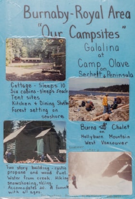
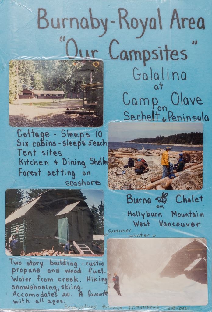
Burnaby - Royal Area "Our Campsites"
https://search.heritageburnaby.ca/link/museumdescription4944
- Repository
- Burnaby Village Museum
- Date
- [ca. 1975]
- Collection/Fonds
- Burnaby Girl Guides fonds
- Description Level
- Item
- Physical Description
- 1 poster : 4 photographs : col. + textual record mounted on board 28 x 40.5 cm and laminated
- Scope and Content
- Item consists of a handwritten poster titled "Burnaby - Royal Area / "Our Campsites"" with four colour photographs of Girl Guide campsites in Sechelt and West Vancouver. Handwritten annotations describe each photograph from the top right to left "Galalina / at / Camp Olave / on / Sechelt Peninsu…
- Repository
- Burnaby Village Museum
- Collection/Fonds
- Burnaby Girl Guides fonds
- Description Level
- Item
- Physical Description
- 1 poster : 4 photographs : col. + textual record mounted on board 28 x 40.5 cm and laminated
- Scope and Content
- Item consists of a handwritten poster titled "Burnaby - Royal Area / "Our Campsites"" with four colour photographs of Girl Guide campsites in Sechelt and West Vancouver. Handwritten annotations describe each photograph from the top right to left "Galalina / at / Camp Olave / on / Sechelt Peninsula" "Cottage - sleeps 10 / Six cabins - sleeps 5each / Tent sites / Kitchen & Dining Shelter / Forest setting on / seashore" "Burna [bee] Chalet / on / Hollyburn Mountain / West Vancouver / Summer / Winter" "Two story building - rustic / propane and wood fuel / Water from creek. Hiking / snowshoeing, skiing. / Accomodates 20. A favourite / with all ages" "Reservations through M. Matthews ___-____"
- Subjects
- Organizations - Girls' Societies and Clubs
- Recreational Activities - Camping
- Natural Phenomena - Snow
- Geographic Features - Beaches
- Names
- Girl Guides of Canada
- Accession Code
- BV015.35.213
- Access Restriction
- No restrictions
- Reproduction Restriction
- May be restricted by third party rights
- Date
- [ca. 1975]
- Media Type
- Photograph
- Textual Record
- Notes
- Transcribed title
Images
Campsite Collection
https://search.heritageburnaby.ca/link/museumdescription4589
- Repository
- Burnaby Village Museum
- Date
- [between 1958 and 2002]
- Collection/Fonds
- Burnaby Girl Guides fonds
- Description Level
- File
- Physical Description
- 1 file : 33 photographs + textual records + other material
- Scope and Content
- File consists of photographs, an illustration, ephemera and histories about Burnaby Guiding Camps including Burnaby Chalet on Cypress Mountain, Galalina Camp at Camp Olave near Sechelt B.C., Burnaby Guide Camp at Wilson Creek and a few postcards of Camp Tsoona, Rosedale B.C. A collection of written…
- Repository
- Burnaby Village Museum
- Collection/Fonds
- Burnaby Girl Guides fonds
- Description Level
- File
- Physical Description
- 1 file : 33 photographs + textual records + other material
- Scope and Content
- File consists of photographs, an illustration, ephemera and histories about Burnaby Guiding Camps including Burnaby Chalet on Cypress Mountain, Galalina Camp at Camp Olave near Sechelt B.C., Burnaby Guide Camp at Wilson Creek and a few postcards of Camp Tsoona, Rosedale B.C. A collection of written material provides historical background regarding the two storey cabin on Hollyburn Mountain. The cabin was purchased by Burnaby Girl Guides in 1964 and appropriately named Burnaby Chalet. A Chalet Committee was formed with representatives from each Division appointing a Chalet Manageress to handle reservations. This typical ski cabin can accomodate up to 40 people. The file also includes a "Campsite Log Book" for the Hollyburn Chalet with handwritten notes from 1981 and 1982, an embroidered triangular shaped badge "Burnaby Royal / Girl Guides / Hollyburn Chalet" and a dedication ceremony program for "Burnaby Guide Camp / June 8, 1958" (Wilson Creek).
- Subjects
- Organizations - Girls' Societies and Clubs
- Recreational Activities - Camping
- Natural Phenomena - Snow
- Geographic Features - Beaches
- Names
- Girl Guides of Canada
- Accession Code
- BV015.35.161
- Access Restriction
- No restrictions
- Reproduction Restriction
- May be restricted by third party rights
- Date
- [between 1958 and 2002]
- Media Type
- Photograph
- Textual Record
- Notes
- Transcribed title

Burnaby Mountain Park
https://search.heritageburnaby.ca/link/archivedescription93639
- Repository
- City of Burnaby Archives
- Date
- November 19, 1977
- Collection/Fonds
- Burnaby Public Library Contemporary Visual Archive Project
- Description Level
- Item
- Physical Description
- 1 photograph : b&w ; 12.5 x 17.5 cm
- Scope and Content
- Photograph of the hillside on the top of Burnaby Mountain Park, with a person in the foreground looking out to the view. The photograph is taken facing northwest and shows the view over the the Burrard Inlet. Capitol Hill, the North Shore Mountains, and downtown Vancouver are visible in the distanc…
- Repository
- City of Burnaby Archives
- Date
- November 19, 1977
- Collection/Fonds
- Burnaby Public Library Contemporary Visual Archive Project
- Physical Description
- 1 photograph : b&w ; 12.5 x 17.5 cm
- Description Level
- Item
- Record No.
- 556-596
- Access Restriction
- No restrictions
- Reproduction Restriction
- Reproduce for fair dealing purposes only
- Accession Number
- 2017-57
- Scope and Content
- Photograph of the hillside on the top of Burnaby Mountain Park, with a person in the foreground looking out to the view. The photograph is taken facing northwest and shows the view over the the Burrard Inlet. Capitol Hill, the North Shore Mountains, and downtown Vancouver are visible in the distance.
- Names
- Burnaby Mountain Park
- Media Type
- Photograph
- Photographer
- van Mannen, Mark
- Notes
- Title taken from project information form
- Accompanied by a project information form and 1 photograph (b&w negative ; 9.5 x 12.5 cm)
- BPL no. 45
- Geographic Access
- Burnaby Mountain Conservation Area
- Planning Study Area
- Burnaby Mountain Area
Images


Burnaby Mountain Park
https://search.heritageburnaby.ca/link/archivedescription93640
- Repository
- City of Burnaby Archives
- Date
- November 19, 1977
- Collection/Fonds
- Burnaby Public Library Contemporary Visual Archive Project
- Description Level
- Item
- Physical Description
- 1 photograph : b&w ; 12.5 x 17.5 cm
- Scope and Content
- Photograph of the top of Burnaby Mountain Park and the view of Vancouver from the hillside, with a man standing in the foreground. The photograph is taken facing west of southwest. Capitol Hill, the Burrard Inlet, the North Shore Mountains, Vancouver, and Stanley Park are visible in the distance.
- Repository
- City of Burnaby Archives
- Date
- November 19, 1977
- Collection/Fonds
- Burnaby Public Library Contemporary Visual Archive Project
- Physical Description
- 1 photograph : b&w ; 12.5 x 17.5 cm
- Description Level
- Item
- Record No.
- 556-597
- Access Restriction
- No restrictions
- Reproduction Restriction
- Reproduce for fair dealing purposes only
- Accession Number
- 2017-57
- Scope and Content
- Photograph of the top of Burnaby Mountain Park and the view of Vancouver from the hillside, with a man standing in the foreground. The photograph is taken facing west of southwest. Capitol Hill, the Burrard Inlet, the North Shore Mountains, Vancouver, and Stanley Park are visible in the distance.
- Names
- Burnaby Mountain Park
- Media Type
- Photograph
- Photographer
- McGillivray, Don
- Notes
- Title taken from project information form
- Accompanied by a project information form and 1 photograph (b&w negative ; 9.5 x 12.5 cm)
- BPL no. 46
- Geographic Access
- Burnaby Mountain Conservation Area
- Planning Study Area
- Burnaby Mountain Area
Images


Burnaby Mountain Park
https://search.heritageburnaby.ca/link/archivedescription93645
- Repository
- City of Burnaby Archives
- Date
- November 19, 1977
- Collection/Fonds
- Burnaby Public Library Contemporary Visual Archive Project
- Description Level
- Item
- Physical Description
- 1 photograph : b&w ; 12.5 x 17.5 cm
- Scope and Content
- Photograph of the view from Burnaby Mountain of the Burrard Inlet, the oil refinery, and the mountains. The photograph is taken from Burnaby Mountain Park, facing north.
- Repository
- City of Burnaby Archives
- Date
- November 19, 1977
- Collection/Fonds
- Burnaby Public Library Contemporary Visual Archive Project
- Physical Description
- 1 photograph : b&w ; 12.5 x 17.5 cm
- Description Level
- Item
- Record No.
- 556-602
- Access Restriction
- No restrictions
- Reproduction Restriction
- Reproduce for fair dealing purposes only
- Accession Number
- 2017-57
- Scope and Content
- Photograph of the view from Burnaby Mountain of the Burrard Inlet, the oil refinery, and the mountains. The photograph is taken from Burnaby Mountain Park, facing north.
- Subjects
- Geographic Features - Inlets
- Geographic Features - Parks
- Geographic Features - Mountains
- Buildings - Industrial - Refineries
- Names
- Burnaby Mountain Park
- Media Type
- Photograph
- Photographer
- van Mannen, Mark
- Notes
- Title taken from project information form
- Accompanied by a project information form and 1 photograph (b&w negative ; 9.5 x 12.5 cm)
- BPL no. 52
- Geographic Access
- Burnaby Mountain Conservation Area
- Burrard Inlet
- Planning Study Area
- Burnaby Mountain Area
Images


Burnaby Mountain Park Looking West
https://search.heritageburnaby.ca/link/archivedescription93707
- Repository
- City of Burnaby Archives
- Date
- February 15, 1978
- Collection/Fonds
- Burnaby Public Library Contemporary Visual Archive Project
- Description Level
- Item
- Physical Description
- 1 photograph : b&w ; 12.5 x 17.5 cm
- Scope and Content
- Photograph of the view from Burnaby Mountain Park. The photograph is taken facing west and shows the park, part of the parking lot at the Burnaby Centennial Pavilion, and Capitol Hill and the mountains in the distance.
- Repository
- City of Burnaby Archives
- Date
- February 15, 1978
- Collection/Fonds
- Burnaby Public Library Contemporary Visual Archive Project
- Physical Description
- 1 photograph : b&w ; 12.5 x 17.5 cm
- Description Level
- Item
- Record No.
- 556-664
- Access Restriction
- No restrictions
- Reproduction Restriction
- Reproduce for fair dealing purposes only
- Accession Number
- 2017-57
- Scope and Content
- Photograph of the view from Burnaby Mountain Park. The photograph is taken facing west and shows the park, part of the parking lot at the Burnaby Centennial Pavilion, and Capitol Hill and the mountains in the distance.
- Subjects
- Geographic Features - Parks
- Geographic Features - Mountains
- Geographic Features - Automobile Parking Lots
- Names
- Burnaby Mountain Park
- Media Type
- Photograph
- Photographer
- Surridge, Jack
- Notes
- Title taken from project information form
- Accompanied by a project information form and 1 photograph (b&w negative ; 9.5 x 12.5 cm)
- BPL no. 112
- Geographic Access
- Burnaby Mountain Conservation Area
- Street Address
- 100 Centennial Way
- Planning Study Area
- Burnaby Mountain Area
Images


Burnaby Lake Show / originals
https://search.heritageburnaby.ca/link/archivedescription91683
- Repository
- City of Burnaby Archives
- Date
- 1962-1995
- Collection/Fonds
- Doreen Lawson fonds
- Description Level
- File
- Physical Description
- 71 photographs : col. slides ; 35 mm
- Scope and Content
- File consists of photographs compiled by Doreen Lawson for a slideshow presentation about Burnaby Lake. Slideshow primarily depicts the wildlife and foliage of Burnaby Lake, including: the American coot, green-winged teal, bufflehead, heron, american bittern, barn swallow, barn owl, painted turtle,…
- Repository
- City of Burnaby Archives
- Date
- 1962-1995
- Collection/Fonds
- Doreen Lawson fonds
- Physical Description
- 71 photographs : col. slides ; 35 mm
- Description Level
- File
- Record No.
- 618-001
- Access Restriction
- No restrictions
- Reproduction Restriction
- May be restricted by third party rights
- Accession Number
- 2015-15
- Scope and Content
- File consists of photographs compiled by Doreen Lawson for a slideshow presentation about Burnaby Lake. Slideshow primarily depicts the wildlife and foliage of Burnaby Lake, including: the American coot, green-winged teal, bufflehead, heron, american bittern, barn swallow, barn owl, painted turtle, muskrat, Canadian goose, beaver, wood duck, bullrushes, yellow and white waterlilies, yellow iris, and loosestrife. Also included in the slideshow are photographs of the BC Wildlife rescue and fisherman working in the Brunette River.
- Subjects
- Geographic Features - Lakes and Ponds
- Animals - Birds
- Animals
- Geographic Features - Forests
- Media Type
- Photograph
- Photographer
- Lawson, Doreen A.
- Chapman, Fred
- Notes
- Transcribed title
- Title transcribed from sheets slides
- Photographs contents are identified on many of the slide cases within the file.
- Historic Neighbourhood
- Burnaby Lake (Historic Neighbourhood)
- Planning Study Area
- Burnaby Lake Area
Images


Burnaby Lake slide show
https://search.heritageburnaby.ca/link/archivedescription91684
- Repository
- City of Burnaby Archives
- Date
- 1976-1999
- Collection/Fonds
- Doreen Lawson fonds
- Description Level
- File
- Physical Description
- 85 photographs : col. slides ; 35 mm
- Scope and Content
- File consists of photographs compiled by Doreen Lawson for slideshow presentations about Burnaby Lake. Slideshow primarily depicts the wildlife and foliage of Burnaby Lake, including: the painted turtle, heron, American coot, coyote, barn owl, rainbow fry, Canadian goose, and beaver, as well as a v…
- Repository
- City of Burnaby Archives
- Date
- 1976-1999
- Collection/Fonds
- Doreen Lawson fonds
- Physical Description
- 85 photographs : col. slides ; 35 mm
- Description Level
- File
- Record No.
- 618-002
- Access Restriction
- No restrictions
- Reproduction Restriction
- May be restricted by third party rights
- Accession Number
- 2015-15
- Scope and Content
- File consists of photographs compiled by Doreen Lawson for slideshow presentations about Burnaby Lake. Slideshow primarily depicts the wildlife and foliage of Burnaby Lake, including: the painted turtle, heron, American coot, coyote, barn owl, rainbow fry, Canadian goose, and beaver, as well as a variety of scenic photographs of the Burnaby Lake shoreline with mountains and the Metrotown skyline in distance. Also included in file are photographs of people canoeing, kayaking, feeding geese, and participating in conservation activities including fencing trees and testing water levels. Photographs also depict the pipeline leading into Burnaby Lake, lake dredging equipment, and an oil slick.
- Subjects
- Geographic Features - Lakes and Ponds
- Animals - Birds
- Animals
- Geographic Features - Forests
- Media Type
- Photograph
- Photographer
- Lawson, Doreen A.
- Notes
- Title based on contents of photographs
- Note in black ink on recto of slide sheet photographs 618-002-1 : 618-002-9 originally housed in read: "Burnby Lake Slideshow"
- Note in black ink on recto of slide sheet photographs 618-002-10 : 608-002-19 originally housed in read: "Burnaby Lake / Rejects (My Fav!)"
- Photographs contents are identified on many of the slide cases within the file.
- Historic Neighbourhood
- Burnaby Lake (Historic Neighbourhood)
- Planning Study Area
- Burnaby Lake Area
Images


Burnaby Mountain Parking Lot & Restaurant
https://search.heritageburnaby.ca/link/archivedescription93706
- Repository
- City of Burnaby Archives
- Date
- February 15, 1978
- Collection/Fonds
- Burnaby Public Library Contemporary Visual Archive Project
- Description Level
- Item
- Physical Description
- 1 photograph : b&w ; 12.5 x 17.5 cm
- Scope and Content
- Photograph of the view of the mountains and park from a hill on Burnaby Mountain Park. The photograph is taken facing north. The photograph shows the parking lot and the Burnaby Mountain Centennial Pavilion.
- Repository
- City of Burnaby Archives
- Date
- February 15, 1978
- Collection/Fonds
- Burnaby Public Library Contemporary Visual Archive Project
- Physical Description
- 1 photograph : b&w ; 12.5 x 17.5 cm
- Description Level
- Item
- Record No.
- 556-663
- Access Restriction
- No restrictions
- Reproduction Restriction
- Reproduce for fair dealing purposes only
- Accession Number
- 2017-57
- Scope and Content
- Photograph of the view of the mountains and park from a hill on Burnaby Mountain Park. The photograph is taken facing north. The photograph shows the parking lot and the Burnaby Mountain Centennial Pavilion.
- Subjects
- Buildings - Commercial - Restaurants
- Buildings - Civic
- Buildings - Recreational
- Geographic Features - Automobile Parking Lots
- Geographic Features - Parks
- Names
- Burnaby Mountain Park
- Media Type
- Photograph
- Photographer
- Surridge, Jack
- Notes
- Title taken from project information form
- Accompanied by a project information form and 1 photograph (b&w negative ; 9.5 x 12.5 cm)
- BPL no. 111
- Geographic Access
- Burnaby Lake Regional Nature Park
- Burnaby Mountain Conservation Area
- Street Address
- 100 Centennial Way
- Planning Study Area
- Burnaby Mountain Area
Images


Byrne Creek
https://search.heritageburnaby.ca/link/archivedescription36107
- Repository
- City of Burnaby Archives
- Date
- February 7, 1979
- Collection/Fonds
- Burnaby Historical Society fonds
- Description Level
- Item
- Physical Description
- 1 photograph : b&w ; 15 x 19.5 cm
- Scope and Content
- Photograph of Byrne Creek at a road's edge.
- Repository
- City of Burnaby Archives
- Date
- February 7, 1979
- Collection/Fonds
- Burnaby Historical Society fonds
- Subseries
- Columbian Newspaper subseries
- Physical Description
- 1 photograph : b&w ; 15 x 19.5 cm
- Description Level
- Item
- Record No.
- 222-030
- Access Restriction
- No restrictions
- Reproduction Restriction
- Reproduce for fair dealing purposes only
- Accession Number
- BHS1989-19
- Scope and Content
- Photograph of Byrne Creek at a road's edge.
- Media Type
- Photograph
- Photographer
- King, Basil
- Notes
- Title based on contents of photograph
- Newspaper clipping glued to verso of photograph reads: "Byrne Creek...fish habitat and a problem for developers."
- Geographic Access
- Byrne Creek
- Historic Neighbourhood
- Fraser Arm (Historic Neighbourhood)
- Planning Study Area
- Big Bend Area
Images


Stream in Robert Burnaby Park
https://search.heritageburnaby.ca/link/archivedescription93668
- Repository
- City of Burnaby Archives
- Date
- January 15, 1978
- Collection/Fonds
- Burnaby Public Library Contemporary Visual Archive Project
- Description Level
- Item
- Physical Description
- 1 photograph : b&w ; 12.5 x 17.5 cm
- Scope and Content
- Photograph of a mostly dry stream in Robert Burnaby Park. The stream is surrounded by a forested area and the photograph shows a footbridge in the background. The photograph is taken in front of the stream, facing south.
- Repository
- City of Burnaby Archives
- Date
- January 15, 1978
- Collection/Fonds
- Burnaby Public Library Contemporary Visual Archive Project
- Physical Description
- 1 photograph : b&w ; 12.5 x 17.5 cm
- Description Level
- Item
- Record No.
- 556-625
- Access Restriction
- No restrictions
- Reproduction Restriction
- Reproduce for fair dealing purposes only
- Accession Number
- 2017-57
- Scope and Content
- Photograph of a mostly dry stream in Robert Burnaby Park. The stream is surrounded by a forested area and the photograph shows a footbridge in the background. The photograph is taken in front of the stream, facing south.
- Media Type
- Photograph
- Photographer
- Surridge, Jack
- Notes
- Title taken from project information form
- Accompanied by a project information form and 1 photograph (b&w negative ; 9.5 x 12.5 cm)
- BPL no. 74
- Geographic Access
- Robert Burnaby Park
- Historic Neighbourhood
- Burnaby Lake (Historic Neighbourhood)
- Planning Study Area
- Lakeview-Mayfield Area
Images

![300 block of Esmonds, [between 1965 and 1970] thumbnail](/media/hpo/_Data/_Archives_Images/_Unrestricted/316/366-017.jpg?width=280)
300 block of Esmonds
https://search.heritageburnaby.ca/link/archivedescription37388
- Repository
- City of Burnaby Archives
- Date
- [between 1965 and 1970]
- Collection/Fonds
- Burnaby Historical Society fonds
- Description Level
- Item
- Physical Description
- 1 photograph : b&w negative
- Scope and Content
- Photograph taken looking south along the 300 block of Esmonds Avenue.
- Repository
- City of Burnaby Archives
- Date
- [between 1965 and 1970]
- Collection/Fonds
- Burnaby Historical Society fonds
- Subseries
- Municipal record subseries
- Physical Description
- 1 photograph : b&w negative
- Description Level
- Item
- Record No.
- 366-017
- Access Restriction
- No restrictions
- Reproduction Restriction
- Reproduce for fair dealing purposes only
- Accession Number
- BHS1998-12
- Scope and Content
- Photograph taken looking south along the 300 block of Esmonds Avenue.
- Subjects
- Geographic Features - Roads
- Media Type
- Photograph
- Notes
- Title based on contents of photograph
- Geographic Access
- Esmond Avenue
- Historic Neighbourhood
- Vancouver Heights (Historic Neighbourhood)
- Planning Study Area
- Burnaby Heights Area
Images
![300 block of Esmonds, [between 1965 and 1970] thumbnail](/media/hpo/_Data/_Archives_Images/_Unrestricted/316/366-017.jpg)
![3900 Albert Street, [between 1965 and 1970] thumbnail](/media/hpo/_Data/_Archives_Images/_Unrestricted/316/366-018.jpg?width=280)
3900 Albert Street
https://search.heritageburnaby.ca/link/archivedescription37389
- Repository
- City of Burnaby Archives
- Date
- [between 1965 and 1970]
- Collection/Fonds
- Burnaby Historical Society fonds
- Description Level
- Item
- Physical Description
- 1 photograph : b&w negative
- Scope and Content
- Photograph of the north side of 3900 Albert Street, looking west. The Vancouver Heights Baptist Church can be seen to the far right (at the corner of Albert Street and Ingleton Avenue).
- Repository
- City of Burnaby Archives
- Date
- [between 1965 and 1970]
- Collection/Fonds
- Burnaby Historical Society fonds
- Subseries
- Municipal record subseries
- Physical Description
- 1 photograph : b&w negative
- Description Level
- Item
- Record No.
- 366-018
- Access Restriction
- No restrictions
- Reproduction Restriction
- Reproduce for fair dealing purposes only
- Accession Number
- BHS1998-12
- Scope and Content
- Photograph of the north side of 3900 Albert Street, looking west. The Vancouver Heights Baptist Church can be seen to the far right (at the corner of Albert Street and Ingleton Avenue).
- Media Type
- Photograph
- Notes
- Title based on contents of photograph
- Geographic Access
- Ingleton Avenue
- Albert Street
- Street Address
- 3900 Albert Street
- 271 Ingleton Avenue
- 3977 Albert Street
- Historic Neighbourhood
- Vancouver Heights (Historic Neighbourhood)
- Planning Study Area
- Burnaby Heights Area
Images
![3900 Albert Street, [between 1965 and 1970] thumbnail](/media/hpo/_Data/_Archives_Images/_Unrestricted/316/366-018.jpg)
![3900 Albert Street at Ingleton Avenue, [between 1965 and 1970] thumbnail](/media/hpo/_Data/_Archives_Images/_Unrestricted/316/366-019.jpg?width=280)
3900 Albert Street at Ingleton Avenue
https://search.heritageburnaby.ca/link/archivedescription37390
- Repository
- City of Burnaby Archives
- Date
- [between 1965 and 1970]
- Collection/Fonds
- Burnaby Historical Society fonds
- Description Level
- Item
- Physical Description
- 1 photograph : b&w negative
- Scope and Content
- Photograph looking west along the north side of Albert Street from the 3900 Block. At the far right can be seen the Vancouver Heights Baptist Church, at the intersection of Albert and Ingleton Avenue.
- Repository
- City of Burnaby Archives
- Date
- [between 1965 and 1970]
- Collection/Fonds
- Burnaby Historical Society fonds
- Subseries
- Municipal record subseries
- Physical Description
- 1 photograph : b&w negative
- Description Level
- Item
- Record No.
- 366-019
- Access Restriction
- No restrictions
- Reproduction Restriction
- Reproduce for fair dealing purposes only
- Accession Number
- BHS1998-12
- Scope and Content
- Photograph looking west along the north side of Albert Street from the 3900 Block. At the far right can be seen the Vancouver Heights Baptist Church, at the intersection of Albert and Ingleton Avenue.
- Media Type
- Photograph
- Notes
- Title based on contents of photograph.
- Geographic Access
- Albert Street
- Ingleton Avenue
- Street Address
- 3900 Albert Street
- 271 Ingleton Avenue
- Historic Neighbourhood
- Vancouver Heights (Historic Neighbourhood)
- Planning Study Area
- Burnaby Heights Area
Images
![3900 Albert Street at Ingleton Avenue, [between 1965 and 1970] thumbnail](/media/hpo/_Data/_Archives_Images/_Unrestricted/316/366-019.jpg)
![3900 Block of Hastings Street, [between 1965 and 1970] thumbnail](/media/hpo/_Data/_Archives_Images/_Unrestricted/316/366-009.jpg?width=280)
3900 Block of Hastings Street
https://search.heritageburnaby.ca/link/archivedescription37380
- Repository
- City of Burnaby Archives
- Date
- [between 1965 and 1970]
- Collection/Fonds
- Burnaby Historical Society fonds
- Description Level
- Item
- Physical Description
- 1 photograph : b&w negative
- Scope and Content
- Photograph looking west along the lane between the 3900 block of Hastings Street and Albert Street. An unidentified man is walking down the lane.
- Repository
- City of Burnaby Archives
- Date
- [between 1965 and 1970]
- Collection/Fonds
- Burnaby Historical Society fonds
- Subseries
- Municipal record subseries
- Physical Description
- 1 photograph : b&w negative
- Description Level
- Item
- Record No.
- 366-009
- Access Restriction
- No restrictions
- Reproduction Restriction
- Reproduce for fair dealing purposes only
- Accession Number
- BHS1998-12
- Scope and Content
- Photograph looking west along the lane between the 3900 block of Hastings Street and Albert Street. An unidentified man is walking down the lane.
- Subjects
- Geographic Features - Lanes
- Media Type
- Photograph
- Notes
- Title based on contents of photograph
- Geographic Access
- Hastings Street
- Historic Neighbourhood
- Vancouver Heights (Historic Neighbourhood)
- Planning Study Area
- Burnaby Heights Area
Images
![3900 Block of Hastings Street, [between 1965 and 1970] thumbnail](/media/hpo/_Data/_Archives_Images/_Unrestricted/316/366-009.jpg)
![3900 Hastings Street, [between 1965 and 1970] thumbnail](/media/hpo/_Data/_Archives_Images/_Unrestricted/316/366-010.jpg?width=280)
3900 Hastings Street
https://search.heritageburnaby.ca/link/archivedescription37381
- Repository
- City of Burnaby Archives
- Date
- [between 1965 and 1970]
- Collection/Fonds
- Burnaby Historical Society fonds
- Description Level
- Item
- Physical Description
- 1 photograph : b&w negative
- Scope and Content
- Photograph taken looking west along Hastings Street, in front of the 3900 Block.
- Repository
- City of Burnaby Archives
- Date
- [between 1965 and 1970]
- Collection/Fonds
- Burnaby Historical Society fonds
- Subseries
- Municipal record subseries
- Physical Description
- 1 photograph : b&w negative
- Description Level
- Item
- Record No.
- 366-010
- Access Restriction
- No restrictions
- Reproduction Restriction
- Reproduce for fair dealing purposes only
- Accession Number
- BHS1998-12
- Scope and Content
- Photograph taken looking west along Hastings Street, in front of the 3900 Block.
- Media Type
- Photograph
- Notes
- Title based on contents of photograph
- Geographic Access
- Hastings Street
- Historic Neighbourhood
- Vancouver Heights (Historic Neighbourhood)
- Planning Study Area
- Burnaby Heights Area
Images
![3900 Hastings Street, [between 1965 and 1970] thumbnail](/media/hpo/_Data/_Archives_Images/_Unrestricted/316/366-010.jpg)
![3951 and 3953 Hastings Street, [between 1965 and 1970] thumbnail](/media/hpo/_Data/_Archives_Images/_Unrestricted/316/366-013.jpg?width=280)
3951 and 3953 Hastings Street
https://search.heritageburnaby.ca/link/archivedescription37384
- Repository
- City of Burnaby Archives
- Date
- [between 1965 and 1970]
- Collection/Fonds
- Burnaby Historical Society fonds
- Description Level
- Item
- Physical Description
- 1 photograph : b&w negative
- Scope and Content
- Photograph of the driveway and lane between 3951 and 3953 Hastings Street. A note on the back of the photograph reads: "3951-53 Hastings Street from lane."
- Repository
- City of Burnaby Archives
- Date
- [between 1965 and 1970]
- Collection/Fonds
- Burnaby Historical Society fonds
- Subseries
- Municipal record subseries
- Physical Description
- 1 photograph : b&w negative
- Description Level
- Item
- Record No.
- 366-013
- Access Restriction
- No restrictions
- Reproduction Restriction
- Reproduce for fair dealing purposes only
- Accession Number
- BHS1998-12
- Scope and Content
- Photograph of the driveway and lane between 3951 and 3953 Hastings Street. A note on the back of the photograph reads: "3951-53 Hastings Street from lane."
- Subjects
- Geographic Features - Lanes
- Media Type
- Photograph
- Notes
- Title based on caption
- Geographic Access
- Hastings Street
- Street Address
- 3951 Hastings Street
- 3953 Hastings Street
- Historic Neighbourhood
- Vancouver Heights (Historic Neighbourhood)
- Planning Study Area
- Burnaby Heights Area
Images
![3951 and 3953 Hastings Street, [between 1965 and 1970] thumbnail](/media/hpo/_Data/_Archives_Images/_Unrestricted/316/366-013.jpg)

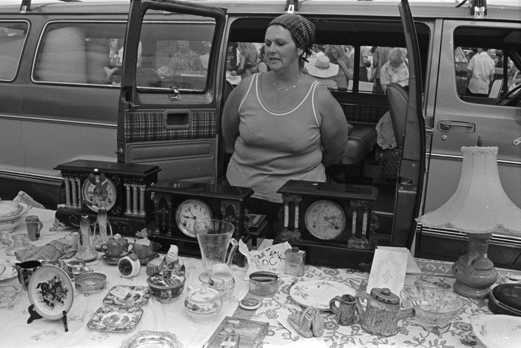
Antique clocks and flatware
https://search.heritageburnaby.ca/link/archivedescription70349
- Repository
- City of Burnaby Archives
- Date
- 1978
- Collection/Fonds
- Bill Jeffries fonds
- Description Level
- Item
- Physical Description
- 1 photograph : b&w negative ; 35 mm
- Scope and Content
- Photograph of a table of antique clocks and flatware at the Lougheed Drive-in swap meet in the summer of 1978. An unidentified vendor is standing behind the table with her hands behind her back.
- Repository
- City of Burnaby Archives
- Date
- 1978
- Collection/Fonds
- Bill Jeffries fonds
- Physical Description
- 1 photograph : b&w negative ; 35 mm
- Description Level
- Item
- Record No.
- 528-045
- Access Restriction
- No restrictions
- Reproduction Restriction
- No restrictions
- Accession Number
- 2011-01
- Scope and Content
- Photograph of a table of antique clocks and flatware at the Lougheed Drive-in swap meet in the summer of 1978. An unidentified vendor is standing behind the table with her hands behind her back.
- Media Type
- Photograph
- Photographer
- Jeffries, Bill
- Notes
- Title based on contents of item
- Geographic Access
- Lougheed Highway
- Historic Neighbourhood
- Broadview (Historic Neighbourhood)
- Planning Study Area
- West Central Valley Area
Images
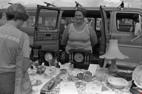
Antique clocks and flatware
https://search.heritageburnaby.ca/link/archivedescription70423
- Repository
- City of Burnaby Archives
- Date
- 1978
- Collection/Fonds
- Bill Jeffries fonds
- Description Level
- Item
- Physical Description
- 1 photograph : b&w negative ; 35 mm
- Scope and Content
- Photograph of a table of antique clocks and flatware at the Lougheed Drive-in swap meet in the summer of 1978. An unidentified vendor is standing behind the table, smiling at a potential customer.
- Repository
- City of Burnaby Archives
- Date
- 1978
- Collection/Fonds
- Bill Jeffries fonds
- Physical Description
- 1 photograph : b&w negative ; 35 mm
- Description Level
- Item
- Record No.
- 528-119
- Access Restriction
- No restrictions
- Reproduction Restriction
- No restrictions
- Accession Number
- 2011-01
- Scope and Content
- Photograph of a table of antique clocks and flatware at the Lougheed Drive-in swap meet in the summer of 1978. An unidentified vendor is standing behind the table, smiling at a potential customer.
- Media Type
- Photograph
- Photographer
- Jeffries, Bill
- Notes
- Title based on contents of item
- Geographic Access
- Lougheed Highway
- Historic Neighbourhood
- Broadview (Historic Neighbourhood)
- Planning Study Area
- West Central Valley Area
Images
