Narrow Results By
Subject
- Advertising Medium - Signs and Signboards 1
- Buildings - Civic - Hospitals 5
- Buildings - Civic - Libraries 2
- Buildings - Commercial - Grocery Stores 1
- Buildings - Commercial - Hardware Stores 15
- Buildings - Heritage 39
- Buildings - Recreational - Community Halls 1
- Buildings - Recreational - Outdoor Swimming Pools 1
- Buildings - Recreational - Swimming Pools 1
- Buildings - Religious - Churches 1
- Buildings - Residential - Houses 12
- Buildings - Schools 4
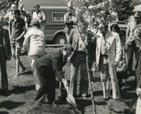
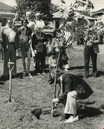
Eastburn Park tree planting ceremony
https://search.heritageburnaby.ca/link/archivedescription38629
- Repository
- City of Burnaby Archives
- Date
- June 8, 1976
- Collection/Fonds
- Burnaby Historical Society fonds
- Description Level
- Item
- Physical Description
- 1 photograph : b&w ; 20.5 x 25.5 cm pasted on cardboard backing
- Scope and Content
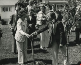
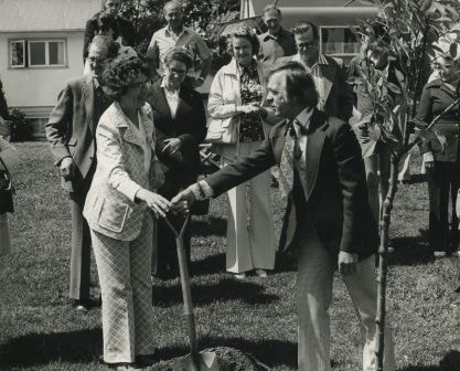
- Photograph of Burnaby Mayor Tom Constable handing a shovel to Robin Sanders as part of the tree planting ceremony at Eastburn Park. Standing behind them, wearing a light coloured jacket is Ethel Widmen.
- Repository
- City of Burnaby Archives
- Date
- June 8, 1976
- Collection/Fonds
- Burnaby Historical Society fonds
- Subseries
- Municipal record subseries
- Physical Description
- 1 photograph : b&w ; 20.5 x 25.5 cm pasted on cardboard backing
- Description Level
- Item
- Record No.
- 467-005
- Access Restriction
- No restrictions
- Reproduction Restriction
- No restrictions
- Accession Number
- BHS2004-5
- Scope and Content
- Photograph of Burnaby Mayor Tom Constable handing a shovel to Robin Sanders as part of the tree planting ceremony at Eastburn Park. Standing behind them, wearing a light coloured jacket is Ethel Widmen.
- Subjects
- Ceremonies
- Officials - Alderman and Councillors
- Officials - Mayors and Reeves
- Geographic Features - Parks
- Media Type
- Photograph
- Notes
- Title based on contents of photograph
- Geographic Access
- Eastburn Park
- 13th Avenue
- Street Address
- 7944 13th Avenue
- Historic Neighbourhood
- East Burnaby (Historic Neighbourhood)
- Planning Study Area
- Second Street Area
Images
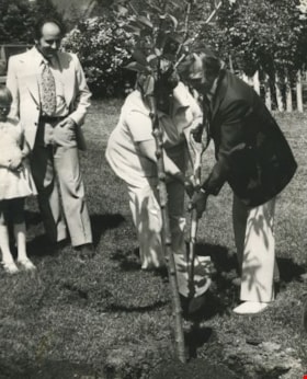
Eastburn Park tree planting ceremony
https://search.heritageburnaby.ca/link/archivedescription38630
- Repository
- City of Burnaby Archives
- Date
- June 8, 1976
- Collection/Fonds
- Burnaby Historical Society fonds
- Description Level
- Item
- Physical Description
- 1 photograph : b&w ; 20.5 x 25.5 cm pasted on cardboard backing
- Scope and Content
- Photograph of Mayor Tom Constable holding a tree at the ceremonial tree planting at Eastburn Park. Standing in the centre of the photograph (wearing light coloured suit) is Burnaby Council member Gerry Ast.
- Repository
- City of Burnaby Archives
- Date
- June 8, 1976
- Collection/Fonds
- Burnaby Historical Society fonds
- Subseries
- Municipal record subseries
- Physical Description
- 1 photograph : b&w ; 20.5 x 25.5 cm pasted on cardboard backing
- Description Level
- Item
- Record No.
- 467-006
- Access Restriction
- No restrictions
- Reproduction Restriction
- No restrictions
- Accession Number
- BHS2004-5
- Scope and Content
- Photograph of Mayor Tom Constable holding a tree at the ceremonial tree planting at Eastburn Park. Standing in the centre of the photograph (wearing light coloured suit) is Burnaby Council member Gerry Ast.
- Subjects
- Ceremonies
- Officials - Alderman and Councillors
- Officials - Mayors and Reeves
- Geographic Features - Parks
- Media Type
- Photograph
- Notes
- Title based on contents of photograph
- Geographic Access
- Eastburn Park
- 13th Avenue
- Street Address
- 7944 13th Avenue
- Historic Neighbourhood
- East Burnaby (Historic Neighbourhood)
- Planning Study Area
- Second Street Area
Images

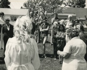
Eastburn Park tree planting ceremony
https://search.heritageburnaby.ca/link/archivedescription38633
- Repository
- City of Burnaby Archives
- Date
- June 8, 1976
- Collection/Fonds
- Burnaby Historical Society fonds
- Description Level
- Item
- Physical Description
- 1 photograph : b&w ; 20.5 x 25 cm pasted on cardboard backing
- Scope and Content
- Photograph of a crowd gathered for a ceremonial tree planting at Eastburn Park. Burnaby Mayor Tom Constable can be seen to the far right (partially obscurred) and to the immediate left of him is Burnaby Council member Gerald Ast. The rest of the crowd is unidenitified.
- Repository
- City of Burnaby Archives
- Date
- June 8, 1976
- Collection/Fonds
- Burnaby Historical Society fonds
- Subseries
- Municipal record subseries
- Physical Description
- 1 photograph : b&w ; 20.5 x 25 cm pasted on cardboard backing
- Description Level
- Item
- Record No.
- 467-009
- Access Restriction
- No restrictions
- Reproduction Restriction
- No restrictions
- Accession Number
- BHS2004-5
- Scope and Content
- Photograph of a crowd gathered for a ceremonial tree planting at Eastburn Park. Burnaby Mayor Tom Constable can be seen to the far right (partially obscurred) and to the immediate left of him is Burnaby Council member Gerald Ast. The rest of the crowd is unidenitified.
- Subjects
- Ceremonies
- Officials - Alderman and Councillors
- Officials - Mayors and Reeves
- Geographic Features - Parks
- Media Type
- Photograph
- Notes
- Title based on contents of photograph
- Geographic Access
- Eastburn Park
- 13th Avenue
- Street Address
- 7944 13th Avenue
- Historic Neighbourhood
- East Burnaby (Historic Neighbourhood)
- Planning Study Area
- Second Street Area
Images

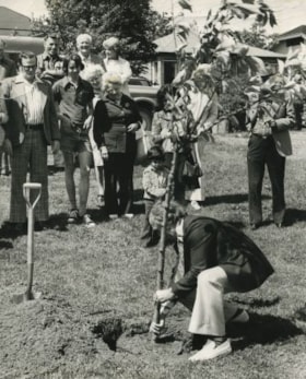
Eastburn Park tree planting ceremony
https://search.heritageburnaby.ca/link/archivedescription38634
- Repository
- City of Burnaby Archives
- Date
- June 8, 1976
- Collection/Fonds
- Burnaby Historical Society fonds
- Description Level
- Item
- Physical Description
- 1 photograph : b&w ; 20.5 x 25.5 cm pasted on cardboard backing
- Scope and Content
- Photograph of a tree planting ceremony at Eastburn Park. Beth Chobotuck is shown holding the shovel at the centre of the picture and Burnaby Mayor Tom Constable is visible at the far right of the photograph (with his side to the camera). To the left of Mayor Constable (wearing light coloured suit…
- Repository
- City of Burnaby Archives
- Date
- June 8, 1976
- Collection/Fonds
- Burnaby Historical Society fonds
- Subseries
- Municipal record subseries
- Physical Description
- 1 photograph : b&w ; 20.5 x 25.5 cm pasted on cardboard backing
- Description Level
- Item
- Record No.
- 467-010
- Access Restriction
- No restrictions
- Reproduction Restriction
- No restrictions
- Accession Number
- BHS2004-5
- Scope and Content
- Photograph of a tree planting ceremony at Eastburn Park. Beth Chobotuck is shown holding the shovel at the centre of the picture and Burnaby Mayor Tom Constable is visible at the far right of the photograph (with his side to the camera). To the left of Mayor Constable (wearing light coloured suit) is Burnaby Council member Gerald Ast. The rest of the people are unidentified.
- Subjects
- Ceremonies
- Officials - Alderman and Councillors
- Officials - Mayors and Reeves
- Geographic Features - Parks
- Media Type
- Photograph
- Notes
- Title based on contents of photograph
- Geographic Access
- Eastburn Park
- 13th Avenue
- Street Address
- 7944 13th Avenue
- Historic Neighbourhood
- East Burnaby (Historic Neighbourhood)
- Planning Study Area
- Second Street Area
Images
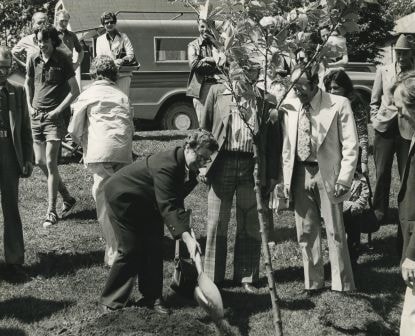
Eastburn Park tree planting ceremony
https://search.heritageburnaby.ca/link/archivedescription38635
- Repository
- City of Burnaby Archives
- Date
- June 8, 1976
- Collection/Fonds
- Burnaby Historical Society fonds
- Description Level
- Item
- Physical Description
- 1 photograph : b&w ; 20.5 x 25.5 cm pasted on cardboard backing
- Scope and Content
- Photograph of Burnaby Mayor Thomas Constable planting a tree at a ceremonial tree planting event at Eastburn Park. None of the members of the crowd gathered behind him are identified.
- Repository
- City of Burnaby Archives
- Date
- June 8, 1976
- Collection/Fonds
- Burnaby Historical Society fonds
- Subseries
- Municipal record subseries
- Physical Description
- 1 photograph : b&w ; 20.5 x 25.5 cm pasted on cardboard backing
- Description Level
- Item
- Record No.
- 467-011
- Access Restriction
- No restrictions
- Reproduction Restriction
- No restrictions
- Accession Number
- BHS2004-5
- Scope and Content
- Photograph of Burnaby Mayor Thomas Constable planting a tree at a ceremonial tree planting event at Eastburn Park. None of the members of the crowd gathered behind him are identified.
- Subjects
- Ceremonies
- Officials - Alderman and Councillors
- Officials - Mayors and Reeves
- Geographic Features - Parks
- Media Type
- Photograph
- Notes
- Title based on contents of photograph
- Geographic Access
- Eastburn Park
- 13th Avenue
- Street Address
- 7944 13th Avenue
- Historic Neighbourhood
- East Burnaby (Historic Neighbourhood)
- Planning Study Area
- Second Street Area
Images
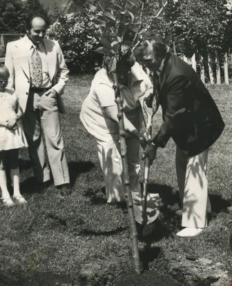
Eastburn Park tree planting ceremony
https://search.heritageburnaby.ca/link/archivedescription38636
- Repository
- City of Burnaby Archives
- Date
- June 8, 1976
- Collection/Fonds
- Burnaby Historical Society fonds
- Description Level
- Item
- Physical Description
- 1 photograph : b&w ; 20.5 x 25 cm pasted on cardboard backing
- Scope and Content
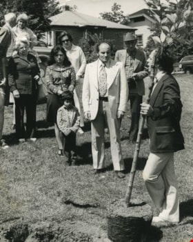
- Photograph of a ceremonial tree planting at Eastburn Park. Pictured are Burnaby Councillor Gerry Ast (standing to the left next to an unidentified child), Jessie Beattie (centre) and Mayor Tom Constable.
- Repository
- City of Burnaby Archives
- Date
- June 8, 1976
- Collection/Fonds
- Burnaby Historical Society fonds
- Subseries
- Municipal record subseries
- Physical Description
- 1 photograph : b&w ; 20.5 x 25 cm pasted on cardboard backing
- Description Level
- Item
- Record No.
- 467-012
- Access Restriction
- No restrictions
- Reproduction Restriction
- No restrictions
- Accession Number
- BHS2004-5
- Scope and Content
- Photograph of a ceremonial tree planting at Eastburn Park. Pictured are Burnaby Councillor Gerry Ast (standing to the left next to an unidentified child), Jessie Beattie (centre) and Mayor Tom Constable.
- Subjects
- Ceremonies
- Officials - Alderman and Councillors
- Officials - Mayors and Reeves
- Geographic Features - Parks
- Media Type
- Photograph
- Notes
- Title based on contents of photograph
- Geographic Access
- Eastburn Park
- 13th Avenue
- Street Address
- 7944 13th Avenue
- Historic Neighbourhood
- East Burnaby (Historic Neighbourhood)
- Planning Study Area
- Second Street Area
Images
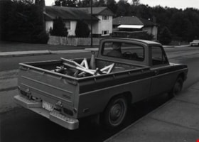
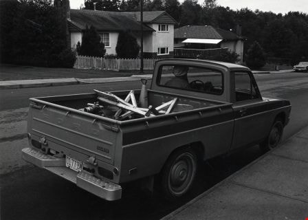
Engineering Department Truck
https://search.heritageburnaby.ca/link/archivedescription79440
- Repository
- City of Burnaby Archives
- Date
- October, 1976
- Collection/Fonds
- Burnaby Public Library Contemporary Visual Archive Project
- Description Level
- Item
- Physical Description
- 1 photograph : b&w ; 11 x 16 cm mounted on cardboard
- Scope and Content
- Photograph shows a District of Burnaby Engineering Department truck with the driver inside, parked on Cumberland Street near 17th Avenue.
- Repository
- City of Burnaby Archives
- Date
- October, 1976
- Collection/Fonds
- Burnaby Public Library Contemporary Visual Archive Project
- Physical Description
- 1 photograph : b&w ; 11 x 16 cm mounted on cardboard
- Description Level
- Item
- Record No.
- 556-292
- Access Restriction
- No restrictions
- Reproduction Restriction
- Reproduce for fair dealing purposes only
- Accession Number
- 2013-13
- Scope and Content
- Photograph shows a District of Burnaby Engineering Department truck with the driver inside, parked on Cumberland Street near 17th Avenue.
- Media Type
- Photograph
- Photographer
- Ross, Martha
- Notes
- Scope note taken directly from BPL photograph description.
- 1 b&w copy negative : 10 x 12.5 cm accompanying
- Geographic Access
- Cumberland Street
- 17th Avenue
- Historic Neighbourhood
- East Burnaby (Historic Neighbourhood)
- Planning Study Area
- Cariboo-Armstrong Area
Images

Exterior of Love farmhouse
https://search.heritageburnaby.ca/link/museumdescription1129
- Repository
- Burnaby Village Museum
- Date
- 1971 (date of original), copied 1990
- Collection/Fonds
- Love family fonds
- Description Level
- Item
- Physical Description
- 1 photograph : col. ; 10 x 15 cm print
- Scope and Content
- Photograph of the northern exterior of the Love farmhouse while Elsie (nee Love) Hughes, her husband John and son Brent lived in the house. The one storey section housed the kitchen which was added in 1903 to the original house which was built in 1893. The house is located at 7651 Cumberland Stree…
- Repository
- Burnaby Village Museum
- Collection/Fonds
- Love family fonds
- Description Level
- Item
- Physical Description
- 1 photograph : col. ; 10 x 15 cm print
- Material Details
- Copy print was made from re-photographing an original colour slide
- Scope and Content
- Photograph of the northern exterior of the Love farmhouse while Elsie (nee Love) Hughes, her husband John and son Brent lived in the house. The one storey section housed the kitchen which was added in 1903 to the original house which was built in 1893. The house is located at 7651 Cumberland Street (Address pre 1960: 1390 Cumberland Road) and was moved from its original site to the Burnaby Village Museum in 1988 and designated a Municipal Heritage Landmark in 1992.
- Geographic Access
- Cumberland Street
- Street Address
- 7651 Cumberland Street
- Accession Code
- BV992.15.10
- Access Restriction
- Restricted access
- Reproduction Restriction
- May be restricted by third party rights
- Date
- 1971 (date of original), copied 1990
- Media Type
- Photograph
- Historic Neighbourhood
- East Burnaby (Historic Neighbourhood)
- Planning Study Area
- Cariboo-Armstrong Area
- Scan Resolution
- 600
- Scan Date
- 01-Jun-09
- Scale
- 100
- Photographer
- Parker, Albert "Bert"
- Notes
- Title based on contents of photograph
Images


Exterior of Love farmhouse
https://search.heritageburnaby.ca/link/museumdescription1130
- Repository
- Burnaby Village Museum
- Date
- 1971 (date of original), copied 1990
- Collection/Fonds
- Love family fonds
- Description Level
- Item
- Physical Description
- 1 photograph : col. ; 10 x 15 cm print
- Scope and Content
- Photograph of the exterior of the west side of the Love farnhouse while Elsie (nee Love) Hughes, her husband John and son Brent lived in the house.The one storey section housed the kitchen which was attached to the main house in 1903. The house was located at 7651 Cumberland Street (Address pre 196…
- Repository
- Burnaby Village Museum
- Collection/Fonds
- Love family fonds
- Description Level
- Item
- Physical Description
- 1 photograph : col. ; 10 x 15 cm print
- Material Details
- Copy print was made from re-photographing an original colour slide
- Scope and Content
- Photograph of the exterior of the west side of the Love farnhouse while Elsie (nee Love) Hughes, her husband John and son Brent lived in the house.The one storey section housed the kitchen which was attached to the main house in 1903. The house was located at 7651 Cumberland Street (Address pre 1960: 1390 Cumberland Road) and was moved from its original site to the Burnaby Village Museum in 1988 and designated a Municipal Heritage Landmark in 1992.
- Geographic Access
- Cumberland Street
- Street Address
- 7651 Cumberland Street
- Accession Code
- BV992.15.11
- Access Restriction
- Restricted access
- Reproduction Restriction
- May be restricted by third party rights
- Date
- 1971 (date of original), copied 1990
- Media Type
- Photograph
- Historic Neighbourhood
- East Burnaby (Historic Neighbourhood)
- Planning Study Area
- Cariboo-Armstrong Area
- Scan Resolution
- 600
- Scan Date
- 01-Jun-09
- Scale
- 100
- Photographer
- Parker, Albert "Bert"
- Notes
- Title based on contents of photograph
Images


Exterior of Love farmhouse
https://search.heritageburnaby.ca/link/museumdescription1131
- Repository
- Burnaby Village Museum
- Date
- 1971 (date of original), copied 1990
- Collection/Fonds
- Love family fonds
- Description Level
- Item
- Physical Description
- 1 photograph : col. ; 10 x 15 cm print
- Scope and Content
- Photograph of the exterior of the Love farmhouse taken from the corner of Fourteenth Avenue and Cumberland Street while Elsie (nee Love) Hughes, her husband John and son Brent lived in the house. The house was located at 7651 Cumberland Street (Address pre 1960: 1390 Cumberland Road) and was moved …
- Repository
- Burnaby Village Museum
- Collection/Fonds
- Love family fonds
- Description Level
- Item
- Physical Description
- 1 photograph : col. ; 10 x 15 cm print
- Material Details
- Copy print was made from re-photographing an original colour slide
- Scope and Content
- Photograph of the exterior of the Love farmhouse taken from the corner of Fourteenth Avenue and Cumberland Street while Elsie (nee Love) Hughes, her husband John and son Brent lived in the house. The house was located at 7651 Cumberland Street (Address pre 1960: 1390 Cumberland Road) and was moved from its original site to the Burnaby Village Museum in 1988 and designated a Municipal Heritage Landmark in 1992.
- Geographic Access
- Cumberland Street
- 14th Avenue
- Street Address
- 7651 Cumberland Street
- Accession Code
- BV992.15.12
- Access Restriction
- Restricted access
- Reproduction Restriction
- May be restricted by third party rights
- Date
- 1971 (date of original), copied 1990
- Media Type
- Photograph
- Historic Neighbourhood
- East Burnaby (Historic Neighbourhood)
- Planning Study Area
- Cariboo-Armstrong Area
- Scan Resolution
- 600
- Scan Date
- 01-Jun-09
- Scale
- 100
- Photographer
- Parker, Albert "Bert"
- Notes
- Title based on contents of photograph
Images

![Exterior view of Love farmhouse, [between 1966 and 1971] thumbnail](/media/hpo/_Data/_BVM_Images/2019/2019_0003_0001_001.jpg?width=280)
Exterior view of Love farmhouse
https://search.heritageburnaby.ca/link/museumdescription9915
- Repository
- Burnaby Village Museum
- Date
- [between 1966 and 1971]
- Collection/Fonds
- Love family fonds
- Description Level
- Item
- Physical Description
- 1 photograph : col. ; 10 x 15 cm print
- Scope and Content
- Photograph of the exterior of the Love farmhouse located at 7651 Cumberland Street (Address pre 1960: 1390 Cumberland Road) with trees and bushes in the front yard and the driveway to the right. This photograph was taken while Elsie Hughes (nee Love), her husband John Hughes and son Brent Hughes li…
- Repository
- Burnaby Village Museum
- Collection/Fonds
- Love family fonds
- Description Level
- Item
- Physical Description
- 1 photograph : col. ; 10 x 15 cm print
- Material Details
- Copy print was made from re-photographing an original colour slide
- Scope and Content
- Photograph of the exterior of the Love farmhouse located at 7651 Cumberland Street (Address pre 1960: 1390 Cumberland Road) with trees and bushes in the front yard and the driveway to the right. This photograph was taken while Elsie Hughes (nee Love), her husband John Hughes and son Brent Hughes lived in the house.
- History
- Elsie is the daughter of Sarah (nee Love) and William Parker. Sarah and William purchased the Love farmhouse in 1928, shortly after the death of Sarah's father, Jesse Love. Sarah and William Parker lived in the house with their three children, Albert, Bill and Elsie. William Parker died in 1961 and Sarah continued to live in the house until 1966 before selling it to her daughter Elsie and son in law John Hughes. Elsie and John lived in the house with their son Brent until 1971.
- Subjects
- Buildings - Heritage
- Geographic Access
- Cumberland Street
- Street Address
- 7651 Cumberland Street
- Accession Code
- BV019.3.1
- Access Restriction
- No restrictions
- Reproduction Restriction
- No known restrictions
- Date
- [between 1966 and 1971]
- Media Type
- Photograph
- Historic Neighbourhood
- East Burnaby (Historic Neighbourhood)
- Planning Study Area
- Cariboo-Armstrong Area
- Scan Resolution
- 300
- Scan Date
- 31-Jan-2019
- Scale
- 96
- Photographer
- Parker, Albert "Bert"
- Notes
- Title based on contents of photograph.
Images
![Exterior view of Love farmhouse, [between 1966 and 1971] thumbnail](/media/hpo/_Data/_BVM_Images/2019/2019_0003_0001_001.jpg)
![Exterior view of Love farmhouse, [between 1966 and 1970] thumbnail](/media/hpo/_Data/_BVM_Images/2019/2019_0003_0003_001.jpg?width=280)
Exterior view of Love farmhouse
https://search.heritageburnaby.ca/link/museumdescription9917
- Repository
- Burnaby Village Museum
- Date
- [between 1966 and 1970]
- Collection/Fonds
- Love family fonds
- Description Level
- Item
- Physical Description
- 1 photograph : col. ; 10 x 15 cm print
- Scope and Content
- Photograph of a side view of the exterior of the Love farmhouse located at 7651 Cumberland Street (Address pre 1960: 1390 Cumberland Road) with trees and bushes along the side of the house and a gravel driveway. In this side view of the house, you can see the kitchen addition and verandah. This pho…
- Repository
- Burnaby Village Museum
- Collection/Fonds
- Love family fonds
- Description Level
- Item
- Physical Description
- 1 photograph : col. ; 10 x 15 cm print
- Material Details
- Copy print was made from re-photographing an original colour slide
- Scope and Content
- Photograph of a side view of the exterior of the Love farmhouse located at 7651 Cumberland Street (Address pre 1960: 1390 Cumberland Road) with trees and bushes along the side of the house and a gravel driveway. In this side view of the house, you can see the kitchen addition and verandah. This photograph was taken while Elsie Hughes (nee Love), her husband John Hughes and son Brent Hughes lived in the house. Elsie is the daughter of Sarah (nee Love) and William Parker. Sarah and William purchased the house in 1928, shortly after the death of Sarah's father, Jesse Love. Sarah and William Parker lived in the house with their three children, Albert, Bill and Elsie. William Parker died in 1961 and Sarah continued to live in the house until 1966 before selling it to her daughter Elsie and son in law John Hughes. Elsie and John lived in the house with their son Brent until 1971.
- Subjects
- Buildings - Heritage
- Geographic Access
- Cumberland Street
- Street Address
- 7651 Cumberland Street
- Accession Code
- BV019.3.3
- Access Restriction
- No restrictions
- Reproduction Restriction
- No known restrictions
- Date
- [between 1966 and 1970]
- Media Type
- Photograph
- Historic Neighbourhood
- East Burnaby (Historic Neighbourhood)
- Planning Study Area
- Cariboo-Armstrong Area
- Scan Resolution
- 600
- Scan Date
- 31-Jan-2019
- Scale
- 96
- Photographer
- Parker, Albert "Bert"
- Notes
- Title based on contents of photograph
Images
![Exterior view of Love farmhouse, [between 1966 and 1970] thumbnail](/media/hpo/_Data/_BVM_Images/2019/2019_0003_0003_001.jpg)
![Exterior view of Love farmhouse, [between 1966 and 1970] thumbnail](/media/hpo/_Data/_BVM_Images/2019/2019_0003_0004_001.jpg?width=280)
Exterior view of Love farmhouse
https://search.heritageburnaby.ca/link/museumdescription9918
- Repository
- Burnaby Village Museum
- Date
- [between 1966 and 1970]
- Collection/Fonds
- Love family fonds
- Description Level
- Item
- Physical Description
- 1 photograph : col. ; 10 x 15 cm print
- Scope and Content
- Photograph of the south east side of the Love farmhouse located at 7651 Cumberland Street (Address pre 1960: 1390 Cumberland Road). Flowers grow on trellises against the verandah and a dog sits on the lawn alongside gardens, trees, wooden chairs and a picnic table. This photograph was taken while E…
- Repository
- Burnaby Village Museum
- Collection/Fonds
- Love family fonds
- Description Level
- Item
- Physical Description
- 1 photograph : col. ; 10 x 15 cm print
- Material Details
- Copy print was made from re-photographing an original colour slide
- Scope and Content
- Photograph of the south east side of the Love farmhouse located at 7651 Cumberland Street (Address pre 1960: 1390 Cumberland Road). Flowers grow on trellises against the verandah and a dog sits on the lawn alongside gardens, trees, wooden chairs and a picnic table. This photograph was taken while Elsie Hughes (nee Love), her husband John Hughes and son Brent Hughes lived in the house. Elsie is the daughter of Sarah (nee Love) and William Parker. Sarah and William purchased the house in 1928, shortly after the death of Sarah's father, Jesse Love. Sarah and William Parker lived in the house with their three children, Albert, Bill and Elsie. William Parker died in 1961 and Sarah continued to live in the house until 1966 before selling it to her daughter Elsie and son in law John Hughes. Elsie and John lived in the house with their son Brent until 1971.
- Subjects
- Buildings - Heritage
- Geographic Access
- Cumberland Street
- Street Address
- 7651 Cumberland Street
- Accession Code
- BV019.3.4
- Access Restriction
- No restrictions
- Reproduction Restriction
- No known restrictions
- Date
- [between 1966 and 1970]
- Media Type
- Photograph
- Historic Neighbourhood
- East Burnaby (Historic Neighbourhood)
- Planning Study Area
- Cariboo-Armstrong Area
- Scan Resolution
- 600
- Scan Date
- 31-Jan-2019
- Scale
- 96
- Photographer
- Parker, Albert "Bert"
- Notes
- Title based on contents of photograph
Images
![Exterior view of Love farmhouse, [between 1966 and 1970] thumbnail](/media/hpo/_Data/_BVM_Images/2019/2019_0003_0004_001.jpg)
![Exterior view of Love farmhouse, [between 1966 and 1970] thumbnail](/media/hpo/_Data/_BVM_Images/2019/2019_0003_0011_001.jpg?width=280)
Exterior view of Love farmhouse
https://search.heritageburnaby.ca/link/museumdescription9921
- Repository
- Burnaby Village Museum
- Date
- [between 1966 and 1970]
- Collection/Fonds
- Love family fonds
- Description Level
- Item
- Physical Description
- 1 photograph : col. ; 10 x 15 cm print
- Scope and Content
- Photograph of the south east side of the Love farmhouse located at 7651 Cumberland Street (Address pre 1960: 1390 Cumberland Road). Flowers are growing on trellises against the pillars of the verandah and there are two wooden lawn chairs and a picnic table on the lawn under a large tree. This photo…
- Repository
- Burnaby Village Museum
- Collection/Fonds
- Love family fonds
- Description Level
- Item
- Physical Description
- 1 photograph : col. ; 10 x 15 cm print
- Material Details
- Copy print was made from re-photographing an original colour slide
- Scope and Content
- Photograph of the south east side of the Love farmhouse located at 7651 Cumberland Street (Address pre 1960: 1390 Cumberland Road). Flowers are growing on trellises against the pillars of the verandah and there are two wooden lawn chairs and a picnic table on the lawn under a large tree. This photograph was taken while Elsie Hughes (nee Love), her husband John Hughes and son Brent Hughes lived in the house. Elsie is the daughter of Sarah (nee Love) and William Parker. Sarah and William purchased the house in 1928, shortly after the death of Sarah's father, Jesse Love. Sarah and William Parker lived in the house with their three children, Albert, Bill and Elsie. William Parker died in 1961 and Sarah continued to live in the house until 1966 before selling it to her daughter Elsie and son in law John Hughes. Elsie and John lived in the house with their son Brent until 1971.
- Subjects
- Buildings - Heritage
- Geographic Access
- Cumberland Street
- Street Address
- 7651 Cumberland Street
- Accession Code
- BV019.3.11
- Access Restriction
- No restrictions
- Reproduction Restriction
- No known restrictions
- Date
- [between 1966 and 1970]
- Media Type
- Photograph
- Historic Neighbourhood
- East Burnaby (Historic Neighbourhood)
- Planning Study Area
- Cariboo-Armstrong Area
- Scan Resolution
- 600
- Scan Date
- 31-Jan-2019
- Scale
- 96
- Photographer
- Parker, Albert "Bert"
- Notes
- Title based on contents of photograph
Images
![Exterior view of Love farmhouse, [between 1966 and 1970] thumbnail](/media/hpo/_Data/_BVM_Images/2019/2019_0003_0011_001.jpg)
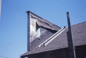
False front and roof of Whitechurch Hardware
https://search.heritageburnaby.ca/link/museumdescription16895
- Repository
- Burnaby Village Museum
- Date
- Aug. 1974
- Collection/Fonds
- Burnaby Village Museum fonds
- Description Level
- Item
- Physical Description
- 1 photograph : col. slide ; 35 mm
- Scope and Content
- Photograph of a portion of the roof with ladder and back of the false front of the Whitechurch Hardware building located at 7685 Sixth Street. The building was being prepared to be moved by the Nickel Brothers house moving company to Heritage Village (Burnaby Village Museum).
- Repository
- Burnaby Village Museum
- Collection/Fonds
- Burnaby Village Museum fonds
- Subseries
- Bell's building photographs subseries
- Description Level
- Item
- Physical Description
- 1 photograph : col. slide ; 35 mm
- Scope and Content
- Photograph of a portion of the roof with ladder and back of the false front of the Whitechurch Hardware building located at 7685 Sixth Street. The building was being prepared to be moved by the Nickel Brothers house moving company to Heritage Village (Burnaby Village Museum).
- Geographic Access
- 6th Street
- Street Address
- 7685 6th Street
- Accession Code
- BV020.5.1865
- Access Restriction
- No restrictions
- Reproduction Restriction
- No known restrictions
- Date
- Aug. 1974
- Media Type
- Photograph
- Historic Neighbourhood
- East Burnaby (Historic Neighbourhood)
- Planning Study Area
- Second Street Area
- Scan Resolution
- 2400
- Scale
- 100
- Notes
- Title based on contents of photograph
- Note in blue ink on slide frame reads: "Whitechurch Hrdwr. / Back of Original / False Front"
Images

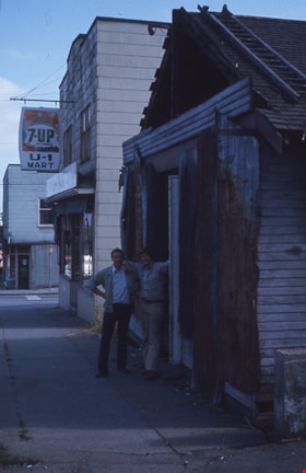
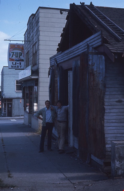
False front removal from Whitechurch Hardware
https://search.heritageburnaby.ca/link/museumdescription16886
- Repository
- Burnaby Village Museum
- Date
- Aug. 1974
- Collection/Fonds
- Burnaby Village Museum fonds
- Description Level
- Item
- Physical Description
- 1 photograph : col. slide ; 35 mm
- Scope and Content
- Photograph of Peter Otten (left) and Gysberton (right) standing in the doorway of the old Whitechurch Hardware building located at 7685 Sixth Street in Burnaby. The building was being prepared to be moved to the Heritage Village (Burnaby Village Museum) and the false front was removed. The Whitech…
- Repository
- Burnaby Village Museum
- Collection/Fonds
- Burnaby Village Museum fonds
- Subseries
- Bell's building photographs subseries
- Description Level
- Item
- Physical Description
- 1 photograph : col. slide ; 35 mm
- Scope and Content
- Photograph of Peter Otten (left) and Gysberton (right) standing in the doorway of the old Whitechurch Hardware building located at 7685 Sixth Street in Burnaby. The building was being prepared to be moved to the Heritage Village (Burnaby Village Museum) and the false front was removed. The Whitechurch Hardware business operated out of this building between 1937 and 1973 and Bell's Dry Goods operated out of this building between 1925 and 1937. A two storey building is visible in the background with a grocery convenience store on the ground level with sign "7-Up / U-1 / Mart" hanging above the entrance way. The two storey building was built in 1938 and operated as Bell's Dry Goods between 1937 and 1941.
- Geographic Access
- 6th Street
- Street Address
- 7695 6th Street
- 7685 6th Street
- Accession Code
- BV020.5.1856
- Access Restriction
- No restrictions
- Reproduction Restriction
- No known restrictions
- Date
- Aug. 1974
- Media Type
- Photograph
- Historic Neighbourhood
- East Burnaby (Historic Neighbourhood)
- Planning Study Area
- Second Street Area
- Scan Resolution
- 2400
- Scale
- 100
- Notes
- Title based on contents of photograph
- Note in blue ink on slide frame reads: "(FRONT) / VIEW FROM THIS SIDE / WRONG SIDE / Whitechurch Hardware / FalseFront Removal / Peter Otten (l) + co. / Gysbertson(r) in front"
- 1 col. copy print accompanying
Images

Front hallway entrance of Love farmhouse
https://search.heritageburnaby.ca/link/museumdescription1122
- Repository
- Burnaby Village Museum
- Date
- 1971 (date of original), copied 1990
- Collection/Fonds
- Love family fonds
- Description Level
- Item
- Physical Description
- 1 photograph : col. ; 15 x 10 cm print
- Scope and Content
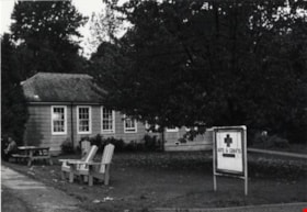
- Photograph of the front hallway and entrance door of the Love farmhouse while Elsie (nee Love) Hughes, her husband John and son Brent lived in the house. The house was located at 7651 Cumberland Street (Address pre 1960: 1390 Cumberland Road) and was moved from its original site to the Burnaby Vill…
- Repository
- Burnaby Village Museum
- Collection/Fonds
- Love family fonds
- Description Level
- Item
- Physical Description
- 1 photograph : col. ; 15 x 10 cm print
- Material Details
- Copy print was made from re-photographing an original colour slide
- Scope and Content
- Photograph of the front hallway and entrance door of the Love farmhouse while Elsie (nee Love) Hughes, her husband John and son Brent lived in the house. The house was located at 7651 Cumberland Street (Address pre 1960: 1390 Cumberland Road) and was moved from its original site to the Burnaby Village Museum in 1988 and designated a Municipal Heritage Landmark in 1992.
- Geographic Access
- Cumberland Street
- Street Address
- 7651 Cumberland Street
- Accession Code
- BV992.15.3
- Access Restriction
- Restricted access
- Reproduction Restriction
- May be restricted by third party rights
- Date
- 1971 (date of original), copied 1990
- Media Type
- Photograph
- Historic Neighbourhood
- East Burnaby (Historic Neighbourhood)
- Planning Study Area
- Cariboo-Armstrong Area
- Scan Resolution
- 600
- Scan Date
- 01-Jun-09
- Scale
- 100
- Photographer
- Parker, Albert "Bert"
- Notes
- Title based on contents of photograph
Images

George Derby Hospital
https://search.heritageburnaby.ca/link/archivedescription79505
- Repository
- City of Burnaby Archives
- Date
- October, 1976
- Collection/Fonds
- Burnaby Public Library Contemporary Visual Archive Project
- Description Level
- Item
- Physical Description
- 1 photograph : b&w ; 11 x 16 cm mounted on cardboard
- Scope and Content
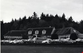
- Photograph of the administration building at George Derby Hospital. George Derby Health and Occupation Centre was constructed during the years 1946/1947. It was officially opened on April 10, 1947 at 7502 Cumberland Street (later 7550 Cumberland), on the corner of 17th Avenue. Its prime function wa…
- Repository
- City of Burnaby Archives
- Date
- October, 1976
- Collection/Fonds
- Burnaby Public Library Contemporary Visual Archive Project
- Physical Description
- 1 photograph : b&w ; 11 x 16 cm mounted on cardboard
- Description Level
- Item
- Record No.
- 556-332
- Access Restriction
- No restrictions
- Reproduction Restriction
- Reproduce for fair dealing purposes only
- Accession Number
- 2013-13
- Scope and Content
- Photograph of the administration building at George Derby Hospital. George Derby Health and Occupation Centre was constructed during the years 1946/1947. It was officially opened on April 10, 1947 at 7502 Cumberland Street (later 7550 Cumberland), on the corner of 17th Avenue. Its prime function was a rehabilitation centre for returning World War II veterans. In the fall of 1962 the Centre was amalgamated with Shaughnessy Hospital (Vancouver) and became the George Derby Wing.
- Subjects
- Buildings - Civic - Hospitals
- Media Type
- Photograph
- Photographer
- Salmon, Stu
- Notes
- Scope note taken directly from BPL photograph description
- 1 b&w copy negative : 10 x 12.5 cm accompanying
- Geographic Access
- Cumberland Street
- Street Address
- 7550 Cumberland Street
- Historic Neighbourhood
- East Burnaby (Historic Neighbourhood)
- Planning Study Area
- Cariboo-Armstrong Area
Images

George Derby Hospital
https://search.heritageburnaby.ca/link/archivedescription79506
- Repository
- City of Burnaby Archives
- Date
- October, 1976
- Collection/Fonds
- Burnaby Public Library Contemporary Visual Archive Project
- Description Level
- Item
- Physical Description
- 1 photograph : b&w ; 11 x 16 cm mounted on cardboard
- Scope and Content
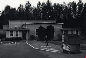
- Photograph shows the treatment building at the George Derby Hospital.
- Repository
- City of Burnaby Archives
- Date
- October, 1976
- Collection/Fonds
- Burnaby Public Library Contemporary Visual Archive Project
- Physical Description
- 1 photograph : b&w ; 11 x 16 cm mounted on cardboard
- Description Level
- Item
- Record No.
- 556-333
- Access Restriction
- No restrictions
- Reproduction Restriction
- Reproduce for fair dealing purposes only
- Accession Number
- 2013-13
- Scope and Content
- Photograph shows the treatment building at the George Derby Hospital.
- Subjects
- Buildings - Civic - Hospitals
- Media Type
- Photograph
- Photographer
- Salmon, Stu
- Notes
- Scope note taken directly from BPL photograph description.
- 1 b&w copy negative : 10 x 12.5 cm accompanying
- Geographic Access
- Cumberland Street
- Street Address
- 7550 Cumberland Street
- Historic Neighbourhood
- East Burnaby (Historic Neighbourhood)
- Planning Study Area
- Cariboo-Armstrong Area
Images
George Derby Hospital
https://search.heritageburnaby.ca/link/archivedescription79507
- Repository
- City of Burnaby Archives
- Date
- October, 1976
- Collection/Fonds
- Burnaby Public Library Contemporary Visual Archive Project
- Description Level
- Item
- Physical Description
- 1 photograph : b&w ; 11 x 16 cm mounted on cardboard
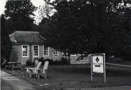
- Scope and Content
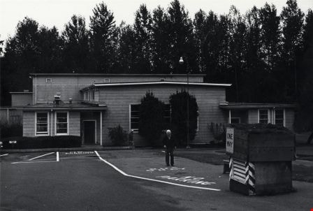
- Photograph shows the arts and crafts building at the George Derby Hospital.
- Repository
- City of Burnaby Archives
- Date
- October, 1976
- Collection/Fonds
- Burnaby Public Library Contemporary Visual Archive Project
- Physical Description
- 1 photograph : b&w ; 11 x 16 cm mounted on cardboard
- Description Level
- Item
- Record No.
- 556-334
- Access Restriction
- No restrictions
- Reproduction Restriction
- Reproduce for fair dealing purposes only
- Accession Number
- 2013-13
- Scope and Content
- Photograph shows the arts and crafts building at the George Derby Hospital.
- Subjects
- Buildings - Civic - Hospitals
- Media Type
- Photograph
- Photographer
- Salmon, Stu
- Notes
- Scope note taken directly from BPL photograph description.
- 1 b&w copy negative : 10 x 12.5 cm accompanying
- Geographic Access
- Cumberland Street
- Street Address
- 7550 Cumberland Street
- Historic Neighbourhood
- East Burnaby (Historic Neighbourhood)
- Planning Study Area
- Cariboo-Armstrong Area
Images