Narrow Results By
Subject
- Advertising Medium - Signs and Signboards
- Aerial Photographs 1
- Animals - Dogs 1
- Buildings - Civic - Archives 1
- Buildings - Civic - City Halls 1
- Buildings - Civic - Fire Halls 1
- Buildings - Civic - Hospitals 2
- Buildings - Commercial 5
- Buildings - Commercial - Offices 1
- Buildings - Commercial - Stores 3
- Buildings - Heritage 5
- Buildings - Industrial 1
7018-7092 Lougheed Hwy [at] SW intersection w/ Bainbridge Ave
https://search.heritageburnaby.ca/link/archivedescription93715
- Repository
- City of Burnaby Archives
- Date
- 1987
- Collection/Fonds
- Grover, Elliott & Co. Ltd. fonds
- Description Level
- File
- Physical Description
- 17 photographs : col. ; 10 cm x 15 cm
- Scope and Content
- Photographs of the commercial properties located at 7018-7092 Lougheed Highway and the surrounding area. Photographs depict the buildings' exteriors, interiors, and roof. Also included in the file is one photograph of a map of Sechelt being marked up.
- Repository
- City of Burnaby Archives
- Date
- 1987
- Collection/Fonds
- Grover, Elliott & Co. Ltd. fonds
- Physical Description
- 17 photographs : col. ; 10 cm x 15 cm
- Description Level
- File
- Record No.
- 622-004
- Access Restriction
- No restrictions
- Reproduction Restriction
- No restrictions
- Accession Number
- 2017-39
- Scope and Content
- Photographs of the commercial properties located at 7018-7092 Lougheed Highway and the surrounding area. Photographs depict the buildings' exteriors, interiors, and roof. Also included in the file is one photograph of a map of Sechelt being marked up.
- Media Type
- Photograph
- Notes
- Transcribed title
- Title transcribed from original print envelope
- File no. 87-201-B
- Geographic Access
- Lougheed Highway
- Street Address
- 7018 Lougheed Highway
- Planning Study Area
- Government Road Area

Foster's Kennels
https://search.heritageburnaby.ca/link/archivedescription79237
- Repository
- City of Burnaby Archives
- Date
- October, 1976
- Collection/Fonds
- Burnaby Public Library Contemporary Visual Archive Project
- Description Level
- Item
- Physical Description
- 1 photograph : b&w ; 11 x 16 cm mounted on cardboard
- Scope and Content
- Photograph shows a guard dog sign at Foster's Kennels, 7287 Lougheed Highway, Foster's Kennels specialized in training attack dogs, both German shepherds and Doberman pinschers. Shortly after the photograph was taken, the kennel relocated to Langley.
- Repository
- City of Burnaby Archives
- Date
- October, 1976
- Collection/Fonds
- Burnaby Public Library Contemporary Visual Archive Project
- Physical Description
- 1 photograph : b&w ; 11 x 16 cm mounted on cardboard
- Description Level
- Item
- Record No.
- 556-216
- Access Restriction
- No restrictions
- Reproduction Restriction
- Reproduce for fair dealing purposes only
- Accession Number
- 2013-13
- Scope and Content
- Photograph shows a guard dog sign at Foster's Kennels, 7287 Lougheed Highway, Foster's Kennels specialized in training attack dogs, both German shepherds and Doberman pinschers. Shortly after the photograph was taken, the kennel relocated to Langley.
- Names
- Foster's Kennels
- Media Type
- Photograph
- Photographer
- McCarron, John
- Notes
- Scope note taken directly from BPL photograph description.
- 1 b&w copy negative : 10 x 12.5 cm accompanying
- Geographic Access
- Lougheed Highway
- Street Address
- 7287 Lougheed Highway
- Historic Neighbourhood
- Lozells (Historic Neighbourhood)
- Planning Study Area
- Government Road Area
Images


BCGEU Protestors
https://search.heritageburnaby.ca/link/archivedescription79500
- Repository
- City of Burnaby Archives
- Date
- October 14, 1976
- Collection/Fonds
- Burnaby Public Library Contemporary Visual Archive Project
- Description Level
- Item
- Physical Description
- 1 photograph : b&w ; 11 x 16 cm mounted on cardboard
- Scope and Content
- Photograph shows two members of the BC Government Employees Union, holding a large sign protesting wage and price controls outside the gates of the Lower Mainland Regional Correctional Centre at 5700 Royal Oak Avenue (later 5220 Oakmount Crescent).
- Repository
- City of Burnaby Archives
- Date
- October 14, 1976
- Collection/Fonds
- Burnaby Public Library Contemporary Visual Archive Project
- Physical Description
- 1 photograph : b&w ; 11 x 16 cm mounted on cardboard
- Description Level
- Item
- Record No.
- 556-329
- Access Restriction
- No restrictions
- Reproduction Restriction
- Reproduce for fair dealing purposes only
- Accession Number
- 2013-13
- Scope and Content
- Photograph shows two members of the BC Government Employees Union, holding a large sign protesting wage and price controls outside the gates of the Lower Mainland Regional Correctional Centre at 5700 Royal Oak Avenue (later 5220 Oakmount Crescent).
- Media Type
- Photograph
- Photographer
- Norton, Paul
- Notes
- Scope note taken directly from BPL photograph description.
- 1 b&w copy negative : 10 x 12.5 cm accompanying
- Geographic Access
- Oakmount Crescent
- Street Address
- 5220 Oakmount Crescent
- 5700 Royal Oak Avenue
- Historic Neighbourhood
- Burnaby Lake (Historic Neighbourhood)
- Planning Study Area
- Oakalla Area
Images

![Highway Improvement Project signage, [1972] thumbnail](/media/hpo/_Data/_Archives_Images/_Unrestricted/480/480-280.jpg?width=280)
Highway Improvement Project signage
https://search.heritageburnaby.ca/link/archivedescription45385
- Repository
- City of Burnaby Archives
- Date
- [1972]
- Collection/Fonds
- Columbian Newspaper collection
- Description Level
- Item
- Physical Description
- 1 photograph : b&w ; 14 x 21 cm
- Scope and Content
- Photograph of Highway Improvement Project signage (developed by the British Columbian Government under W.A.C. Bennett) along the Trans Canada Highway.
- Repository
- City of Burnaby Archives
- Date
- [1972]
- Collection/Fonds
- Columbian Newspaper collection
- Physical Description
- 1 photograph : b&w ; 14 x 21 cm
- Description Level
- Item
- Record No.
- 480-280
- Access Restriction
- No restrictions
- Reproduction Restriction
- No restrictions
- Accession Number
- 2003-02
- Scope and Content
- Photograph of Highway Improvement Project signage (developed by the British Columbian Government under W.A.C. Bennett) along the Trans Canada Highway.
- Media Type
- Photograph
- Photographer
- King, Basil
- Notes
- Title based on contents of photograph
Images
![Highway Improvement Project signage, [1972] thumbnail](/media/hpo/_Data/_Archives_Images/_Unrestricted/480/480-280.jpg)

Quesnel Greene Construction
https://search.heritageburnaby.ca/link/archivedescription79014
- Repository
- City of Burnaby Archives
- Date
- October 23, 1976
- Collection/Fonds
- Burnaby Public Library Contemporary Visual Archive Project
- Description Level
- Item
- Physical Description
- 1 photograph : b&w ; 11 x 16 cm mounted on cardboard
- Scope and Content
- Photograph shows Quesnel Greene construction sign located at the corner of Aquarius Drive and Centaurus Circle. The Quesnel Green Co-operative Housing project was designed by Neinhaker/Irwin Associates and was built by Dunhill Development Corporation Ltd. It was owned by the Government of British…
- Repository
- City of Burnaby Archives
- Date
- October 23, 1976
- Collection/Fonds
- Burnaby Public Library Contemporary Visual Archive Project
- Physical Description
- 1 photograph : b&w ; 11 x 16 cm mounted on cardboard
- Description Level
- Item
- Record No.
- 556-091
- Access Restriction
- No restrictions
- Reproduction Restriction
- Reproduce for fair dealing purposes only
- Accession Number
- 2013-13
- Scope and Content
- Photograph shows Quesnel Greene construction sign located at the corner of Aquarius Drive and Centaurus Circle. The Quesnel Green Co-operative Housing project was designed by Neinhaker/Irwin Associates and was built by Dunhill Development Corporation Ltd. It was owned by the Government of British Columbia.
- Media Type
- Photograph
- Photographer
- Campbell, Peg
- Notes
- Scope note taken directly from BPL photograph description.
- 1 b&w copy negative : 10 x 12.5 cm accompanying
- Geographic Access
- Centaurus Circle
- Aquarius Drive
- Historic Neighbourhood
- Burquitlam (Historic Neighbourhood)
- Planning Study Area
- Lyndhurst Area
Images

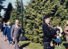
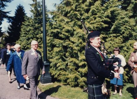
Seaforth School dedication
https://search.heritageburnaby.ca/link/archivedescription35124
- Repository
- City of Burnaby Archives
- Date
- April 1987
- Collection/Fonds
- Burnaby Historical Society fonds
- Description Level
- Item
- Physical Description
- 1 photograph : col. ; 12.6 x 17.4 cm print
- Scope and Content
- Photograph of the opening of Seaforth School at the Burnaby Village Museum, with a piper leading the procession. The school was moved from its original location at 7881 Government Road to Burnaby Village Museum in 1983, and was opened to the public in 1987.
- Repository
- City of Burnaby Archives
- Date
- April 1987
- Collection/Fonds
- Burnaby Historical Society fonds
- Subseries
- Donald N. Brown subseries
- Physical Description
- 1 photograph : col. ; 12.6 x 17.4 cm print
- Description Level
- Item
- Record No.
- 194-001
- Access Restriction
- No restrictions
- Reproduction Restriction
- Reproduce for fair dealing purposes only
- Accession Number
- BHS1987-03
- Scope and Content
- Photograph of the opening of Seaforth School at the Burnaby Village Museum, with a piper leading the procession. The school was moved from its original location at 7881 Government Road to Burnaby Village Museum in 1983, and was opened to the public in 1987.
- Media Type
- Photograph
- Notes
- Title based on contents of photograph
- An annotation on the back of the photograph reads; "Bell Irving, Brig. / Honourary Colonel Seaforths / Dedication of Seaforth School / Burnaby Heritage Village / April, 1987 / Being "Piped" in followed by x-students."
- Geographic Access
- Deer Lake Drive
- Street Address
- 6501 Deer Lake Avenue
- Historic Neighbourhood
- Burnaby Lake (Historic Neighbourhood)
- Planning Study Area
- Morley-Buckingham Area
Images