Narrow Results By
Subject
- Academic Disciplines 3
- Accidents - Train Accidents 1
- Adornment - Jewelry 1
- Advertising Medium
- Advertising Medium - Signs and Signboards 9
- Aerial Photographs 49
- Agricultural Tools and Equipment 4
- Agricultural Tools and Equipment - Gardening Equipment 1
- Agricultural Tools and Equipment - Plows 3
- Agriculture 5
- Agriculture - Dairy 2
- Agriculture - Farms 18
![3900 Block of Hastings Street, [between 1965 and 1970] thumbnail](/media/hpo/_Data/_Archives_Images/_Unrestricted/316/366-009.jpg?width=280)
3900 Block of Hastings Street
https://search.heritageburnaby.ca/link/archivedescription37380
- Repository
- City of Burnaby Archives
- Date
- [between 1965 and 1970]
- Collection/Fonds
- Burnaby Historical Society fonds
- Description Level
- Item
- Physical Description
- 1 photograph : b&w negative
- Scope and Content
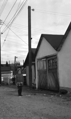
- Photograph looking west along the lane between the 3900 block of Hastings Street and Albert Street. An unidentified man is walking down the lane.
- Repository
- City of Burnaby Archives
- Date
- [between 1965 and 1970]
- Collection/Fonds
- Burnaby Historical Society fonds
- Subseries
- Municipal record subseries
- Physical Description
- 1 photograph : b&w negative
- Description Level
- Item
- Record No.
- 366-009
- Access Restriction
- No restrictions
- Reproduction Restriction
- Reproduce for fair dealing purposes only
- Accession Number
- BHS1998-12
- Scope and Content
- Photograph looking west along the lane between the 3900 block of Hastings Street and Albert Street. An unidentified man is walking down the lane.
- Subjects
- Geographic Features - Lanes
- Media Type
- Photograph
- Notes
- Title based on contents of photograph
- Geographic Access
- Hastings Street
- Historic Neighbourhood
- Vancouver Heights (Historic Neighbourhood)
- Planning Study Area
- Burnaby Heights Area
Images
![3900 Block of Hastings Street, [between 1965 and 1970] thumbnail](/media/hpo/_Data/_Archives_Images/_Unrestricted/316/366-009.jpg)
![3951 and 3953 Hastings Street, [between 1965 and 1970] thumbnail](/media/hpo/_Data/_Archives_Images/_Unrestricted/316/366-013.jpg?width=280)
3951 and 3953 Hastings Street
https://search.heritageburnaby.ca/link/archivedescription37384
- Repository
- City of Burnaby Archives
- Date
- [between 1965 and 1970]
- Collection/Fonds
- Burnaby Historical Society fonds
- Description Level
- Item
- Physical Description
- 1 photograph : b&w negative
- Scope and Content
- Photograph of the driveway and lane between 3951 and 3953 Hastings Street. A note on the back of the photograph reads: "3951-53 Hastings Street from lane."
- Repository
- City of Burnaby Archives
- Date
- [between 1965 and 1970]
- Collection/Fonds
- Burnaby Historical Society fonds
- Subseries
- Municipal record subseries
- Physical Description
- 1 photograph : b&w negative
- Description Level
- Item
- Record No.
- 366-013
- Access Restriction
- No restrictions
- Reproduction Restriction
- Reproduce for fair dealing purposes only
- Accession Number
- BHS1998-12
- Scope and Content
- Photograph of the driveway and lane between 3951 and 3953 Hastings Street. A note on the back of the photograph reads: "3951-53 Hastings Street from lane."
- Subjects
- Geographic Features - Lanes
- Media Type
- Photograph
- Notes
- Title based on caption
- Geographic Access
- Hastings Street
- Street Address
- 3951 Hastings Street
- 3953 Hastings Street
- Historic Neighbourhood
- Vancouver Heights (Historic Neighbourhood)
- Planning Study Area
- Burnaby Heights Area
Images
![3951 and 3953 Hastings Street, [between 1965 and 1970] thumbnail](/media/hpo/_Data/_Archives_Images/_Unrestricted/316/366-013.jpg)

The "Back Lane"
https://search.heritageburnaby.ca/link/archivedescription91858
- Repository
- City of Burnaby Archives
- Date
- 1965
- Collection/Fonds
- Small family fonds
- Description Level
- Item
- Physical Description
- 1 photograph : b&w ; 9.5 cm x 9.5 cm
- Scope and Content
- Photograph of the back lane between Dominion Street and Norfolk Street. The lane is filled with trees, including a large cedar tree (centre) and cherry tree (left). The photograph was taken looking east along the lane. In 1965-66 the lane was put through from Douglas Road to Royal Oak and the tr…
- Repository
- City of Burnaby Archives
- Date
- 1965
- Collection/Fonds
- Small family fonds
- Physical Description
- 1 photograph : b&w ; 9.5 cm x 9.5 cm
- Description Level
- Item
- Record No.
- 620-039
- Access Restriction
- No restrictions
- Reproduction Restriction
- No reproduction permitted
- Accession Number
- 2017-01
- Scope and Content
- Photograph of the back lane between Dominion Street and Norfolk Street. The lane is filled with trees, including a large cedar tree (centre) and cherry tree (left). The photograph was taken looking east along the lane. In 1965-66 the lane was put through from Douglas Road to Royal Oak and the trees and undergrowth were removed.
- Media Type
- Photograph
- Notes
- Transcribed title
- Title transcribed from donor's notes
- Note in blue ink on verso of photograph reads: "P.2"
- Note in blue ink on verso of photograph reads: "Old Cedar Tree - chopped down for alley - Fall - 1965"
- Caption on border of recto of photograph reads: "Dec"
- Geographic Access
- Dominion Street
- Historic Neighbourhood
- Burnaby Lake (Historic Neighbourhood)
- Planning Study Area
- Ardingley-Sprott Area
Images

George Peoples
https://search.heritageburnaby.ca/link/archivedescription46129
- Repository
- City of Burnaby Archives
- Date
- June 1967, published June 8, 1967
- Collection/Fonds
- Columbian Newspaper collection
- Description Level
- Item
- Physical Description
- 1 photograph : b&w ; 20 x 13.5 cm
- Scope and Content
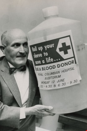
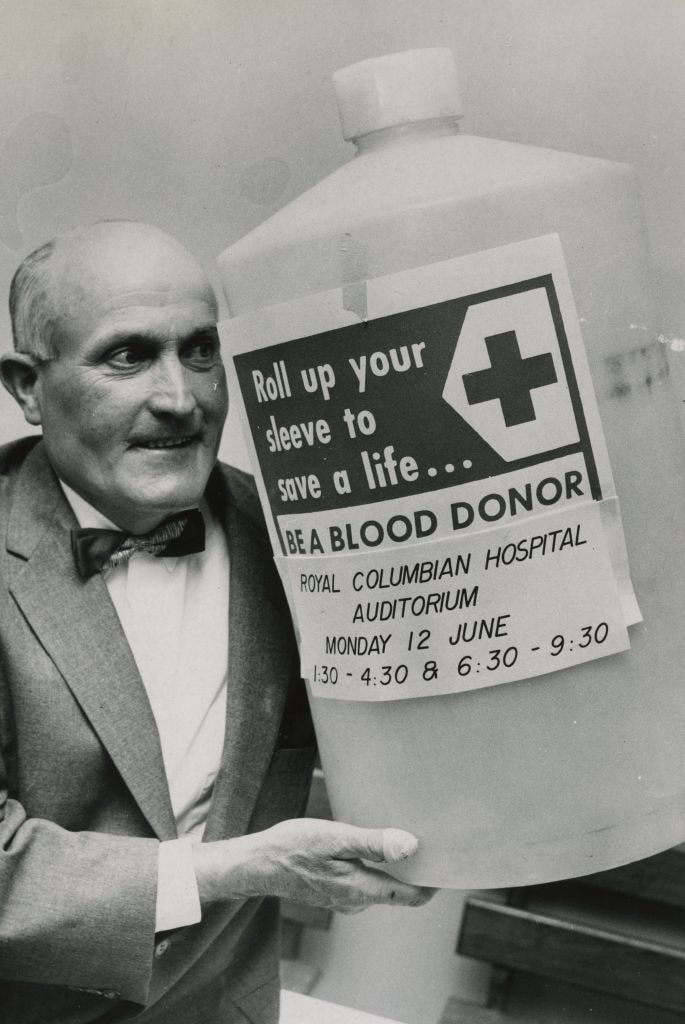
- Photograph of George Peoples holding up a 10 gallon bottle which is labeled; "Roll up your sleeve to save a life ... BE A BLOOD DONOR / ROYAL COLUMBIAN HOSPITAL AUDITORIUM / MONDAY 12 JUNE / 1:30 - 4:30 & 6:30 - 9:30". At the time this photograph was taken, George A. Peoples had already donated 89 …
- Repository
- City of Burnaby Archives
- Date
- June 1967, published June 8, 1967
- Collection/Fonds
- Columbian Newspaper collection
- Physical Description
- 1 photograph : b&w ; 20 x 13.5 cm
- Description Level
- Item
- Record No.
- 480-1017
- Access Restriction
- No restrictions
- Reproduction Restriction
- Reproduce for fair dealing purposes only
- Accession Number
- 2003-02
- Scope and Content
- Photograph of George Peoples holding up a 10 gallon bottle which is labeled; "Roll up your sleeve to save a life ... BE A BLOOD DONOR / ROYAL COLUMBIAN HOSPITAL AUDITORIUM / MONDAY 12 JUNE / 1:30 - 4:30 & 6:30 - 9:30". At the time this photograph was taken, George A. Peoples had already donated 89 pints of blood, and planned to donate another pint that month.
- Subjects
- Advertising Medium
- Media Type
- Photograph
- Photographer
- Timbrell, Don
- Notes
- Title based on contents of photograph
Images
![Hotel Burnaby Ltd., [1955] thumbnail](/media/hpo/_Data/_Archives_Images/_Unrestricted/371/474-001.jpg?width=280)
Hotel Burnaby Ltd.
https://search.heritageburnaby.ca/link/archivedescription38656
- Repository
- City of Burnaby Archives
- Date
- [1955]
- Collection/Fonds
- Burnaby Historical Society fonds
- Description Level
- Item
- Physical Description
- 1 photograph : col. postcard ; 9 x 14 cm
- Scope and Content
- Photographic postcard of Burnaby Hotel located at 1385 Kingsway (old street numbering system). Printed at the bottom of the postcard is the following: Hotel Burnaby Ltd. / 1385 Kingsway at 14th Avenue / Burnaby 3, New Westminster, B.C., Telephone LA 1-8891. On the reverse is written: "Hotel Burna…
- Repository
- City of Burnaby Archives
- Date
- [1955]
- Collection/Fonds
- Burnaby Historical Society fonds
- Subseries
- Jim Wolf subseries
- Physical Description
- 1 photograph : col. postcard ; 9 x 14 cm
- Description Level
- Item
- Record No.
- 474-001
- Access Restriction
- No restrictions
- Reproduction Restriction
- Reproduce for fair dealing purposes only
- Accession Number
- BHS2005-6
- Scope and Content
- Photographic postcard of Burnaby Hotel located at 1385 Kingsway (old street numbering system). Printed at the bottom of the postcard is the following: Hotel Burnaby Ltd. / 1385 Kingsway at 14th Avenue / Burnaby 3, New Westminster, B.C., Telephone LA 1-8891. On the reverse is written: "Hotel Burnaby: Located between new Simpson-Sears and new Woodwards shopping centres. You will remember Hotel Burnaby for the rest of your life."
- Subjects
- Buildings - Commercial - Hotels and Motels
- Documentary Artifacts - Postcards
- Advertising Medium
- Names
- Hotel Burnaby Limited
- Media Type
- Photograph
- Photographer
- Grant-Mann Lithographers Limited
- Notes
- Title based on caption of postcard
- Made by Grant-Mann Lithographers Ltd. "Colour Card" Division, Vancouver British Columbia
- Geographic Access
- Kingsway
- Historic Neighbourhood
- Edmonds (Historic Neighbourhood)
- Planning Study Area
- Stride Avenue Area
Images
![Hotel Burnaby Ltd., [1955] thumbnail](/media/hpo/_Data/_Archives_Images/_Unrestricted/371/474-001.jpg)
Wendy Jonhston
https://search.heritageburnaby.ca/link/archivedescription51400
- Repository
- City of Burnaby Archives
- Date
- 1964
- Collection/Fonds
- Harold H. Johnston fonds
- Description Level
- Item
- Physical Description
- 1 photograph (jpeg) : b&w
- Scope and Content
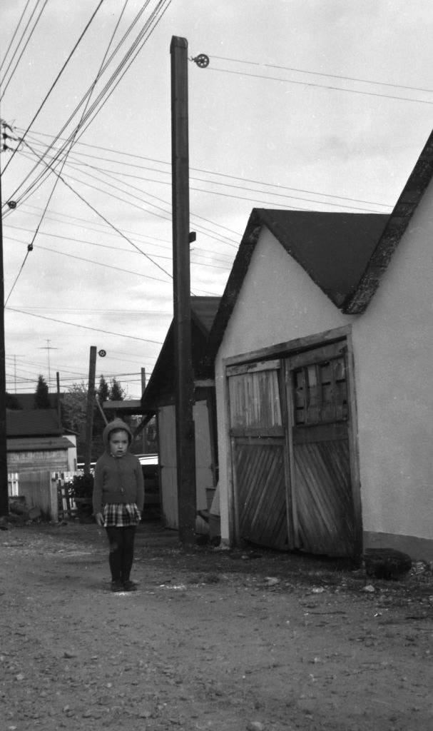
- Photograph of Wendy Johnston standing outside in the lane near the Johnston family home in the 4400 Block of Venables Street.
- Repository
- City of Burnaby Archives
- Date
- 1964
- Collection/Fonds
- Harold H. Johnston fonds
- Physical Description
- 1 photograph (jpeg) : b&w
- Description Level
- Item
- Record No.
- 483-034
- Access Restriction
- No restrictions
- Reproduction Restriction
- No reproduction permitted
- Accession Number
- 2008-08
- Scope and Content
- Photograph of Wendy Johnston standing outside in the lane near the Johnston family home in the 4400 Block of Venables Street.
- Subjects
- Geographic Features - Lanes
- Names
- Johnston, Dr. Wendy
- Media Type
- Photograph
- Photographer
- Johnston, Harold H.
- Notes
- Title based on contents of photograph
- Geographic Access
- Venables Street
- Street Address
- 4447 Venables Street
- Historic Neighbourhood
- Vancouver Heights (Historic Neighbourhood)
- Planning Study Area
- Willingdon Heights Area
Images