Narrow Results By
Subject
- Advertising Medium - Signs and Signboards 1
- Animals - Horses 1
- Buildings - Commercial - Drive-in Theatres 7
- Buildings - Commercial - Hotels and Motels 1
- Buildings - Commercial - Malls 3
- Buildings - Industrial 1
- Buildings - Religious - Churches 2
- Buildings - Residential - Houses 7
- Documentary Artifacts - Postcards 1
- Fountains 1
- Geographic Features - Automobile Parking Lots 1
- Geographic Features - Roads 4
![3900 Albert Street, [between 1965 and 1970] thumbnail](/media/hpo/_Data/_Archives_Images/_Unrestricted/316/366-018.jpg?width=280)
3900 Albert Street
https://search.heritageburnaby.ca/link/archivedescription37389
- Repository
- City of Burnaby Archives
- Date
- [between 1965 and 1970]
- Collection/Fonds
- Burnaby Historical Society fonds
- Description Level
- Item
- Physical Description
- 1 photograph : b&w negative
- Scope and Content
- Photograph of the north side of 3900 Albert Street, looking west. The Vancouver Heights Baptist Church can be seen to the far right (at the corner of Albert Street and Ingleton Avenue).
- Repository
- City of Burnaby Archives
- Date
- [between 1965 and 1970]
- Collection/Fonds
- Burnaby Historical Society fonds
- Subseries
- Municipal record subseries
- Physical Description
- 1 photograph : b&w negative
- Description Level
- Item
- Record No.
- 366-018
- Access Restriction
- No restrictions
- Reproduction Restriction
- Reproduce for fair dealing purposes only
- Accession Number
- BHS1998-12
- Scope and Content
- Photograph of the north side of 3900 Albert Street, looking west. The Vancouver Heights Baptist Church can be seen to the far right (at the corner of Albert Street and Ingleton Avenue).
- Media Type
- Photograph
- Notes
- Title based on contents of photograph
- Geographic Access
- Ingleton Avenue
- Albert Street
- Street Address
- 3900 Albert Street
- 271 Ingleton Avenue
- 3977 Albert Street
- Historic Neighbourhood
- Vancouver Heights (Historic Neighbourhood)
- Planning Study Area
- Burnaby Heights Area
Images
![3900 Albert Street, [between 1965 and 1970] thumbnail](/media/hpo/_Data/_Archives_Images/_Unrestricted/316/366-018.jpg)
![3900 Albert Street at Ingleton Avenue, [between 1965 and 1970] thumbnail](/media/hpo/_Data/_Archives_Images/_Unrestricted/316/366-019.jpg?width=280)
3900 Albert Street at Ingleton Avenue
https://search.heritageburnaby.ca/link/archivedescription37390
- Repository
- City of Burnaby Archives
- Date
- [between 1965 and 1970]
- Collection/Fonds
- Burnaby Historical Society fonds
- Description Level
- Item
- Physical Description
- 1 photograph : b&w negative
- Scope and Content
- Photograph looking west along the north side of Albert Street from the 3900 Block. At the far right can be seen the Vancouver Heights Baptist Church, at the intersection of Albert and Ingleton Avenue.
- Repository
- City of Burnaby Archives
- Date
- [between 1965 and 1970]
- Collection/Fonds
- Burnaby Historical Society fonds
- Subseries
- Municipal record subseries
- Physical Description
- 1 photograph : b&w negative
- Description Level
- Item
- Record No.
- 366-019
- Access Restriction
- No restrictions
- Reproduction Restriction
- Reproduce for fair dealing purposes only
- Accession Number
- BHS1998-12
- Scope and Content
- Photograph looking west along the north side of Albert Street from the 3900 Block. At the far right can be seen the Vancouver Heights Baptist Church, at the intersection of Albert and Ingleton Avenue.
- Media Type
- Photograph
- Notes
- Title based on contents of photograph.
- Geographic Access
- Albert Street
- Ingleton Avenue
- Street Address
- 3900 Albert Street
- 271 Ingleton Avenue
- Historic Neighbourhood
- Vancouver Heights (Historic Neighbourhood)
- Planning Study Area
- Burnaby Heights Area
Images
![3900 Albert Street at Ingleton Avenue, [between 1965 and 1970] thumbnail](/media/hpo/_Data/_Archives_Images/_Unrestricted/316/366-019.jpg)
![3900 Albert Street - South Side, [196-] thumbnail](/media/hpo/_Data/_Archives_Images/_Unrestricted/316/366-027.jpg?width=280)
3900 Albert Street - South Side
https://search.heritageburnaby.ca/link/archivedescription97610
- Repository
- City of Burnaby Archives
- Date
- [196-]
- Collection/Fonds
- Burnaby Historical Society fonds
- Description Level
- Item
- Physical Description
- 1 photograph : b&w negative
- Scope and Content
- Photograph of two houses on the south corner of Albert Street and Ingleton Avenue at 3900 Albert Street.
- Repository
- City of Burnaby Archives
- Date
- [196-]
- Collection/Fonds
- Burnaby Historical Society fonds
- Subseries
- Municipal record subseries
- Physical Description
- 1 photograph : b&w negative
- Description Level
- Item
- Record No.
- 366-027
- Access Restriction
- No restrictions
- Reproduction Restriction
- Reproduce for fair dealing purposes only
- Accession Number
- BHS1998-12
- Scope and Content
- Photograph of two houses on the south corner of Albert Street and Ingleton Avenue at 3900 Albert Street.
- Subjects
- Buildings - Residential - Houses
- Media Type
- Photograph
- Notes
- Transcribed title
- Note on verso of photograph in black ink reads: "3900 Albert - South Side - Two Houses at East End of Block"
- Geographic Access
- Albert Street
- Street Address
- 3900 Albert Street
- Historic Neighbourhood
- Vancouver Heights (Historic Neighbourhood)
- Planning Study Area
- Burnaby Heights Area
Images
![3900 Albert Street - South Side, [196-] thumbnail](/media/hpo/_Data/_Archives_Images/_Unrestricted/316/366-027.jpg)
![3980 Albert Street, [between 1965 and 1970] thumbnail](/media/hpo/_Data/_Archives_Images/_Unrestricted/316/366-024.jpg?width=280)
3980 Albert Street
https://search.heritageburnaby.ca/link/archivedescription37395
- Repository
- City of Burnaby Archives
- Date
- [between 1965 and 1970]
- Collection/Fonds
- Burnaby Historical Society fonds
- Description Level
- Item
- Physical Description
- 1 photograph : b&w negative
- Scope and Content
- Photograph of the home located at 3980 Albert Street (old street number).
- Repository
- City of Burnaby Archives
- Date
- [between 1965 and 1970]
- Collection/Fonds
- Burnaby Historical Society fonds
- Subseries
- Municipal record subseries
- Physical Description
- 1 photograph : b&w negative
- Description Level
- Item
- Record No.
- 366-024
- Access Restriction
- No restrictions
- Reproduction Restriction
- Reproduce for fair dealing purposes only
- Accession Number
- BHS1998-12
- Scope and Content
- Photograph of the home located at 3980 Albert Street (old street number).
- Subjects
- Buildings - Residential - Houses
- Media Type
- Photograph
- Notes
- Title based on contents of photograph
- Geographic Access
- Albert Street
- Historic Neighbourhood
- Vancouver Heights (Historic Neighbourhood)
- Planning Study Area
- Burnaby Heights Area
Images
![3980 Albert Street, [between 1965 and 1970] thumbnail](/media/hpo/_Data/_Archives_Images/_Unrestricted/316/366-024.jpg)
![3980 Albert Street, [between 1965 and 1970] thumbnail](/media/hpo/_Data/_Archives_Images/_Unrestricted/316/366-025.jpg?width=280)
3980 Albert Street
https://search.heritageburnaby.ca/link/archivedescription37396
- Repository
- City of Burnaby Archives
- Date
- [between 1965 and 1970]
- Collection/Fonds
- Burnaby Historical Society fonds
- Description Level
- Item
- Physical Description
- 1 photograph : b&w negative
- Scope and Content
- Photograph of a house located at 3980 Albert Street (old street number).
- Repository
- City of Burnaby Archives
- Date
- [between 1965 and 1970]
- Collection/Fonds
- Burnaby Historical Society fonds
- Subseries
- Municipal record subseries
- Physical Description
- 1 photograph : b&w negative
- Description Level
- Item
- Record No.
- 366-025
- Access Restriction
- No restrictions
- Reproduction Restriction
- Reproduce for fair dealing purposes only
- Accession Number
- BHS1998-12
- Scope and Content
- Photograph of a house located at 3980 Albert Street (old street number).
- Subjects
- Buildings - Residential - Houses
- Media Type
- Photograph
- Notes
- Title based on contents of photograph
- Geographic Access
- Albert Street
- Historic Neighbourhood
- Vancouver Heights (Historic Neighbourhood)
- Planning Study Area
- Burnaby Heights Area
Images
![3980 Albert Street, [between 1965 and 1970] thumbnail](/media/hpo/_Data/_Archives_Images/_Unrestricted/316/366-025.jpg)

Brentwood
https://search.heritageburnaby.ca/link/archivedescription51415
- Repository
- City of Burnaby Archives
- Date
- 1966
- Collection/Fonds
- Harold H. Johnston fonds
- Description Level
- Item
- Physical Description
- 1 photograph (jpeg) : b&w
- Scope and Content
- Photograph is a panoramic view of the Brentwood Shopping Centre, taken from the parking lot.
- Repository
- City of Burnaby Archives
- Date
- 1966
- Collection/Fonds
- Harold H. Johnston fonds
- Physical Description
- 1 photograph (jpeg) : b&w
- Description Level
- Item
- Record No.
- 483-049
- Access Restriction
- No restrictions
- Reproduction Restriction
- No reproduction permitted
- Accession Number
- 2008-08
- Scope and Content
- Photograph is a panoramic view of the Brentwood Shopping Centre, taken from the parking lot.
- Media Type
- Photograph
- Photographer
- Johnston, Harold H.
- Notes
- Title based on contents of photograph
- Geographic Access
- Lougheed Highway
- Street Address
- 4567 Lougheed Highway
- Planning Study Area
- Brentwood Area
Images

![Brentwood Shopping Centre, [196-] thumbnail](/media/hpo/_Data/_Archives_Images/_Unrestricted/126/195-002.jpg?width=280)
Brentwood Shopping Centre
https://search.heritageburnaby.ca/link/archivedescription35132
- Repository
- City of Burnaby Archives
- Date
- [196-]
- Collection/Fonds
- Burnaby Historical Society fonds
- Description Level
- Item
- Physical Description
- 1 photograph : col. postcard ; 8.9 x 14.0 cm
- Scope and Content
- Postcard cosisting of four photographs of Brentwood Shopping Centre. The description printed on the back of the postcard reads, "Brentwood Shopping Centre / Lougheed and Willingdon, Burnaby, B.C. Free parking for 2500 cars. Eaton's of Canada - three floors of air-conditioned shopping comfort. Fo…
- Repository
- City of Burnaby Archives
- Date
- [196-]
- Collection/Fonds
- Burnaby Historical Society fonds
- Subseries
- Evelyn Salisbury subseries
- Physical Description
- 1 photograph : col. postcard ; 8.9 x 14.0 cm
- Description Level
- Item
- Record No.
- 195-002
- Access Restriction
- No restrictions
- Reproduction Restriction
- Reproduce for fair dealing purposes only
- Accession Number
- BHS1987-04
- Scope and Content
- Postcard cosisting of four photographs of Brentwood Shopping Centre. The description printed on the back of the postcard reads, "Brentwood Shopping Centre / Lougheed and Willingdon, Burnaby, B.C. Free parking for 2500 cars. Eaton's of Canada - three floors of air-conditioned shopping comfort. Fountain Square. Loblaw's ... B.C.'s Largest Supermarket." The cost to mail the postcard is listed as four cents. Some of the stores visible are: Bank of Montreal, Heywood Floors, The Doll House Restaurant, Eaton's of Canada, Loblaws, Fields, and Zeller's.
- Subjects
- Geographic Features - Automobile Parking Lots
- Fountains
- Documentary Artifacts - Postcards
- Buildings - Commercial - Malls
- Media Type
- Photograph
- Photographer
- Ford, Rolly
- Notes
- Title based on contents of photograph
- Geographic Access
- Lougheed Highway
- Street Address
- 4567 Lougheed Highway
- Planning Study Area
- Brentwood Area
Images
![Brentwood Shopping Centre, [196-] thumbnail](/media/hpo/_Data/_Archives_Images/_Unrestricted/126/195-002.jpg)
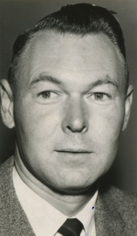
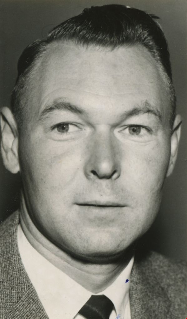
Clifton G. Brown
https://search.heritageburnaby.ca/link/archivedescription45169
- Repository
- City of Burnaby Archives
- Date
- 1961, published August 15, 1961
- Collection/Fonds
- Columbian Newspaper collection
- Description Level
- Item
- Physical Description
- 1 photograph : b&w ; 7.5 x 4.5 cm
- Scope and Content
- Photograph of Clifton G. Brown, bank manager for the then newly built Bank of Montreal at Brentwood shopping centre.
- Repository
- City of Burnaby Archives
- Date
- 1961, published August 15, 1961
- Collection/Fonds
- Columbian Newspaper collection
- Physical Description
- 1 photograph : b&w ; 7.5 x 4.5 cm
- Description Level
- Item
- Record No.
- 480-065
- Access Restriction
- No restrictions
- Reproduction Restriction
- Reproduce for fair dealing purposes only
- Accession Number
- 2003-02
- Scope and Content
- Photograph of Clifton G. Brown, bank manager for the then newly built Bank of Montreal at Brentwood shopping centre.
- Subjects
- Occupations
- Media Type
- Photograph
- Notes
- Title based on contents of photograph
- Geographic Access
- Lougheed Highway
- Street Address
- 4567 Lougheed Highway
- Planning Study Area
- Brentwood Area
Images
![Cypress Equipment building, [1965] thumbnail](/media/hpo/_Data/_Archives_Images/_Unrestricted/001/075-001.jpg?width=280)
Cypress Equipment building
https://search.heritageburnaby.ca/link/archivedescription34641
- Repository
- City of Burnaby Archives
- Date
- [1965]
- Collection/Fonds
- Burnaby Historical Society fonds
- Description Level
- Item
- Physical Description
- 1 photograph : b&w ; 20.5 x 25.7 cm
- Scope and Content
- Photograph of the exterior of the Cypress Equipment building at Lougheed Highway and Holdom Avenue.
- Repository
- City of Burnaby Archives
- Date
- [1965]
- Collection/Fonds
- Burnaby Historical Society fonds
- Subseries
- Photographs subseries
- Physical Description
- 1 photograph : b&w ; 20.5 x 25.7 cm
- Description Level
- Item
- Record No.
- 075-001
- Access Restriction
- No restrictions
- Reproduction Restriction
- Reproduce for fair dealing purposes only
- Accession Number
- BHS2007-04
- Scope and Content
- Photograph of the exterior of the Cypress Equipment building at Lougheed Highway and Holdom Avenue.
- Subjects
- Buildings - Industrial
- Names
- Cypress Equipment
- Media Type
- Photograph
- Notes
- Title based on contents of photograph
- Geographic Access
- Lougheed Highway
- Holdom Avenue
Images
![Cypress Equipment building, [1965] thumbnail](/media/hpo/_Data/_Archives_Images/_Unrestricted/001/075-001.jpg)
![Digney film 1 - Digney's at Brentwood mall, [between 1961 and 1963] (date of original), copied 2019 thumbnail](/media/hpo/_Data/_BVM_Moving_Images/2019_0018_0003_004.jpg?width=280)
Digney film 1 - Digney's at Brentwood mall
https://search.heritageburnaby.ca/link/museumdescription10601
- Repository
- Burnaby Village Museum
- Date
- [between 1961 and 1963] (date of original), copied 2019
- Collection/Fonds
- Digney Family fonds
- Description Level
- Item
- Physical Description
- 1 video recording (mp4) (12 sec.) : digital, 24 fps, col., si.
- Scope and Content
- Film clip of Andy Digney, Alice Digney and Joyce Digney walking along a sidewalk outside stores at Brentwood mall in Burnaby. The Brentwood Shopping Centre opened in August 1961.
- Repository
- Burnaby Village Museum
- Collection/Fonds
- Digney Family fonds
- Description Level
- Item
- Physical Description
- 1 video recording (mp4) (12 sec.) : digital, 24 fps, col., si.
- Scope and Content
- Film clip of Andy Digney, Alice Digney and Joyce Digney walking along a sidewalk outside stores at Brentwood mall in Burnaby. The Brentwood Shopping Centre opened in August 1961.
- Creator
- Digney, Andy
- Subjects
- Buildings - Commercial - Malls
- Geographic Access
- Lougheed Highway
- Street Address
- 4567 Lougheed Highway
- Accession Code
- BV019.18.3.4
- Access Restriction
- No restrictions
- Reproduction Restriction
- No known restrictions
- Date
- [between 1961 and 1963] (date of original), copied 2019
- Media Type
- Moving Images
- Planning Study Area
- Brentwood Area
- Notes
- Title based on contents of film segment
- Film segment originates from digitized version of original 8 mm film (See BV019.18.3)
Images
![Digney film 1 - Digney's at Brentwood mall, [between 1961 and 1963] (date of original), copied 2019 thumbnail](/media/hpo/_Data/_BVM_Moving_Images/2019_0018_0003_004.jpg)
Video
Digney film 1 - Digney's at Brentwood mall, [between 1961 and 1963] (date of original), copied 2019
Digney film 1 - Digney's at Brentwood mall, [between 1961 and 1963] (date of original), copied 2019
https://search.heritageburnaby.ca/media/hpo/_Data/_BVM_Moving_Images/2019_0018_0003_004.mp4![Houses at the east end of Albert Street, [1965] thumbnail](/media/hpo/_Data/_Archives_Images/_Unrestricted/316/366-021.jpg?width=280)
Houses at the east end of Albert Street
https://search.heritageburnaby.ca/link/archivedescription37392
- Repository
- City of Burnaby Archives
- Date
- [1965]
- Collection/Fonds
- Burnaby Historical Society fonds
- Description Level
- Item
- Physical Description
- 1 photograph : b&w negative
- Scope and Content
- Photograph of two houses located at the east end of the 3900 block of Albert Street.
- Repository
- City of Burnaby Archives
- Date
- [1965]
- Collection/Fonds
- Burnaby Historical Society fonds
- Subseries
- Municipal record subseries
- Physical Description
- 1 photograph : b&w negative
- Description Level
- Item
- Record No.
- 366-021
- Access Restriction
- No restrictions
- Reproduction Restriction
- Reproduce for fair dealing purposes only
- Accession Number
- BHS1998-12
- Scope and Content
- Photograph of two houses located at the east end of the 3900 block of Albert Street.
- Subjects
- Buildings - Residential - Houses
- Media Type
- Photograph
- Notes
- Title based on contents of photograph
- Geographic Access
- Albert Street
- Street Address
- 3900 Albert Street
- Historic Neighbourhood
- Vancouver Heights (Historic Neighbourhood)
- Planning Study Area
- Burnaby Heights Area
Images
![Houses at the east end of Albert Street, [1965] thumbnail](/media/hpo/_Data/_Archives_Images/_Unrestricted/316/366-021.jpg)
![Houses at the south side of 3900 Albert Street, [1965] thumbnail](/media/hpo/_Data/_Archives_Images/_Unrestricted/316/366-023.jpg?width=280)
Houses at the south side of 3900 Albert Street
https://search.heritageburnaby.ca/link/archivedescription37394
- Repository
- City of Burnaby Archives
- Date
- [1965]
- Collection/Fonds
- Burnaby Historical Society fonds
- Description Level
- Item
- Physical Description
- 1 photograph : b&w negative
- Scope and Content
- Photograph taken looking east along the south side of 3900 Albert Street.
- Repository
- City of Burnaby Archives
- Date
- [1965]
- Collection/Fonds
- Burnaby Historical Society fonds
- Subseries
- Municipal record subseries
- Physical Description
- 1 photograph : b&w negative
- Description Level
- Item
- Record No.
- 366-023
- Access Restriction
- No restrictions
- Reproduction Restriction
- Reproduce for fair dealing purposes only
- Accession Number
- BHS1998-12
- Scope and Content
- Photograph taken looking east along the south side of 3900 Albert Street.
- Media Type
- Photograph
- Notes
- Title based on contents of photograph.
- Geographic Access
- Albert Street
- Street Address
- 3900 Albert Street
- Historic Neighbourhood
- Vancouver Heights (Historic Neighbourhood)
- Planning Study Area
- Burnaby Heights Area
Images
![Houses at the south side of 3900 Albert Street, [1965] thumbnail](/media/hpo/_Data/_Archives_Images/_Unrestricted/316/366-023.jpg)
![Lane Between Albert Street and Hastings Street, [196-] thumbnail](/media/hpo/_Data/_Archives_Images/_Unrestricted/316/366-026.jpg?width=280)
Lane Between Albert Street and Hastings Street
https://search.heritageburnaby.ca/link/archivedescription37397
- Repository
- City of Burnaby Archives
- Date
- [196-]
- Collection/Fonds
- Burnaby Historical Society fonds
- Description Level
- Item
- Physical Description
- 1 photograph : b&w negative
- Scope and Content
- Photograph shows three cars parked in the lane at 3900 Albert Street, between Albert and Hastings Street, looking north.
- Repository
- City of Burnaby Archives
- Date
- [196-]
- Collection/Fonds
- Burnaby Historical Society fonds
- Subseries
- Municipal record subseries
- Physical Description
- 1 photograph : b&w negative
- Description Level
- Item
- Record No.
- 366-026
- Access Restriction
- No restrictions
- Reproduction Restriction
- Reproduce for fair dealing purposes only
- Accession Number
- BHS1998-12
- Scope and Content
- Photograph shows three cars parked in the lane at 3900 Albert Street, between Albert and Hastings Street, looking north.
- Media Type
- Photograph
- Notes
- Title based on contents of photograph
- Geographic Access
- Albert Street
- Street Address
- 3900 Albert Street
- Historic Neighbourhood
- Vancouver Heights (Historic Neighbourhood)
- Planning Study Area
- Burnaby Heights Area
Images
![Lane Between Albert Street and Hastings Street, [196-] thumbnail](/media/hpo/_Data/_Archives_Images/_Unrestricted/316/366-026.jpg)
![Lindsay Johnson at the Lougheed Drive-In Theatre, [1964] (date of original), copied 1991 thumbnail](/media/hpo/_Data/_Archives_Images/_Unrestricted/370/370-477.jpg?width=280)
Lindsay Johnson at the Lougheed Drive-In Theatre
https://search.heritageburnaby.ca/link/archivedescription37889
- Repository
- City of Burnaby Archives
- Date
- [1964] (date of original), copied 1991
- Collection/Fonds
- Burnaby Historical Society fonds
- Description Level
- Item
- Physical Description
- 1 photograph : b&w ; 2.9 x 4.4 cm print on contact sheet 20.4 x 26.9 cm
- Scope and Content
- Photograph of Lindsay Johnson at the Lougheed Drive-In Theatre on the 4200 block of Lougheed Highway at Gilmore Avenue, in the snow.
- Repository
- City of Burnaby Archives
- Date
- [1964] (date of original), copied 1991
- Collection/Fonds
- Burnaby Historical Society fonds
- Subseries
- Burnaby Image Bank subseries
- Physical Description
- 1 photograph : b&w ; 2.9 x 4.4 cm print on contact sheet 20.4 x 26.9 cm
- Description Level
- Item
- Record No.
- 370-477
- Access Restriction
- No restrictions
- Reproduction Restriction
- No restrictions
- Accession Number
- BHS1999-03
- Scope and Content
- Photograph of Lindsay Johnson at the Lougheed Drive-In Theatre on the 4200 block of Lougheed Highway at Gilmore Avenue, in the snow.
- Names
- Johnson, Lindsay
- Media Type
- Photograph
- Notes
- Title based on contents of photograph
- 1 b&w copy negative accompanying
- Negative has a pink cast
- Copied from col. photograph
- Geographic Access
- Lougheed Highway
- Historic Neighbourhood
- Broadview (Historic Neighbourhood)
- Planning Study Area
- West Central Valley Area
Images
![Lindsay Johnson at the Lougheed Drive-In Theatre, [1964] (date of original), copied 1991 thumbnail](/media/hpo/_Data/_Archives_Images/_Unrestricted/370/370-477.jpg)
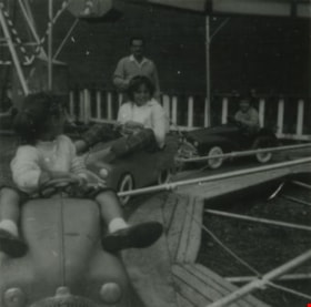
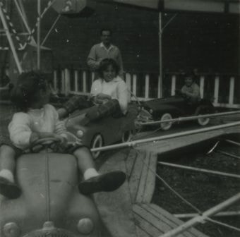
Lougheed Drive-In Theatre children's ride
https://search.heritageburnaby.ca/link/archivedescription37896
- Repository
- City of Burnaby Archives
- Date
- 1960 (date of original), copied 1991
- Collection/Fonds
- Burnaby Historical Society fonds
- Description Level
- Item
- Physical Description
- 1 photograph : b&w ; 3.0 x 3.0 cm print on contact sheet 20.4 x 26.9 cm
- Scope and Content
- Photograph of a children's ride at the Lougheed Drive-In Theatre on the 4200 block of Lougheed Highway at Gilmore Avenue.
- Repository
- City of Burnaby Archives
- Date
- 1960 (date of original), copied 1991
- Collection/Fonds
- Burnaby Historical Society fonds
- Subseries
- Burnaby Image Bank subseries
- Physical Description
- 1 photograph : b&w ; 3.0 x 3.0 cm print on contact sheet 20.4 x 26.9 cm
- Description Level
- Item
- Record No.
- 370-484
- Access Restriction
- No restrictions
- Reproduction Restriction
- No restrictions
- Accession Number
- BHS1999-03
- Scope and Content
- Photograph of a children's ride at the Lougheed Drive-In Theatre on the 4200 block of Lougheed Highway at Gilmore Avenue.
- Media Type
- Photograph
- Notes
- Title based on contents of photograph
- 1 b&w copy negative accompanying
- Negative has a pink cast
- Geographic Access
- Lougheed Highway
- Historic Neighbourhood
- Broadview (Historic Neighbourhood)
- Planning Study Area
- West Central Valley Area
Images
![Lougheed Drive-In Theatre storm damage, [1962] (date of original), copied 1991 thumbnail](/media/hpo/_Data/_Archives_Images/_Unrestricted/370/370-469.jpg?width=280)
Lougheed Drive-In Theatre storm damage
https://search.heritageburnaby.ca/link/archivedescription37881
- Repository
- City of Burnaby Archives
- Date
- [1962] (date of original), copied 1991
- Collection/Fonds
- Burnaby Historical Society fonds
- Description Level
- Item
- Physical Description
- 1 photograph : b&w ; 3.0 x 3.0 cm print on contact sheet 20.1 x 26.7 cm
- Scope and Content
- Photograph of the damage caused by Typhoon "Freda" on October 12, 1962 to the tower and screen of the Lougheed Drive-In Theatre on the 4200 block of Lougheed Highway at Gilmore Avenue.
- Repository
- City of Burnaby Archives
- Date
- [1962] (date of original), copied 1991
- Collection/Fonds
- Burnaby Historical Society fonds
- Subseries
- Burnaby Image Bank subseries
- Physical Description
- 1 photograph : b&w ; 3.0 x 3.0 cm print on contact sheet 20.1 x 26.7 cm
- Description Level
- Item
- Record No.
- 370-469
- Access Restriction
- No restrictions
- Reproduction Restriction
- No restrictions
- Accession Number
- BHS1999-03
- Scope and Content
- Photograph of the damage caused by Typhoon "Freda" on October 12, 1962 to the tower and screen of the Lougheed Drive-In Theatre on the 4200 block of Lougheed Highway at Gilmore Avenue.
- Media Type
- Photograph
- Notes
- Title based on contents of photograph
- 1 b&w copy negative accompanying
- Copy negative has a pink cast
- 2 b&w copy prints accompanying
- Geographic Access
- Lougheed Highway
- Historic Neighbourhood
- Broadview (Historic Neighbourhood)
- Planning Study Area
- West Central Valley Area
Images
![Lougheed Drive-In Theatre storm damage, [1962] (date of original), copied 1991 thumbnail](/media/hpo/_Data/_Archives_Images/_Unrestricted/370/370-469.jpg)
![Lougheed Drive-In Theatre storm damage, [1962] (date of original), copied 1991 thumbnail](/media/hpo/_Data/_Archives_Images/_Unrestricted/370/370-470.jpg?width=280)
Lougheed Drive-In Theatre storm damage
https://search.heritageburnaby.ca/link/archivedescription37882
- Repository
- City of Burnaby Archives
- Date
- [1962] (date of original), copied 1991
- Collection/Fonds
- Burnaby Historical Society fonds
- Description Level
- Item
- Physical Description
- 1 photograph : b&w ; 2.9 x 3.0 cm print on contact sheet 20.1 x 26.7 cm
- Scope and Content
- Photograph of damage caused by Typhoon "Freda" on October 12, 1962 to the screen of the Lougheed Drive-In Theatre on the 4200 block of Lougheed Highway at Gilmore Avenue.
- Repository
- City of Burnaby Archives
- Date
- [1962] (date of original), copied 1991
- Collection/Fonds
- Burnaby Historical Society fonds
- Subseries
- Burnaby Image Bank subseries
- Physical Description
- 1 photograph : b&w ; 2.9 x 3.0 cm print on contact sheet 20.1 x 26.7 cm
- Description Level
- Item
- Record No.
- 370-470
- Access Restriction
- No restrictions
- Reproduction Restriction
- No restrictions
- Accession Number
- BHS1999-03
- Scope and Content
- Photograph of damage caused by Typhoon "Freda" on October 12, 1962 to the screen of the Lougheed Drive-In Theatre on the 4200 block of Lougheed Highway at Gilmore Avenue.
- Media Type
- Photograph
- Notes
- Title based on contents of photograph
- 1 b&w copy negative accompanying
- Negative has a pink cast
- Geographic Access
- Lougheed Highway
- Historic Neighbourhood
- Broadview (Historic Neighbourhood)
- Planning Study Area
- West Central Valley Area
Images
![Lougheed Drive-In Theatre storm damage, [1962] (date of original), copied 1991 thumbnail](/media/hpo/_Data/_Archives_Images/_Unrestricted/370/370-470.jpg)
![Lougheed Drive-In Theatre storm damage, [1962] (date of original), copied 1991 thumbnail](/media/hpo/_Data/_Archives_Images/_Unrestricted/370/370-471.jpg?width=280)
Lougheed Drive-In Theatre storm damage
https://search.heritageburnaby.ca/link/archivedescription37883
- Repository
- City of Burnaby Archives
- Date
- [1962] (date of original), copied 1991
- Collection/Fonds
- Burnaby Historical Society fonds
- Description Level
- Item
- Physical Description
- 1 photograph : b&w ; 3.0 x 2.9 cm print on contact sheet 20.1 x 26.7 cm
- Scope and Content
- Photograph of damage caused by Typhoon "Freda" on October 12, 1962 to the fence at the Lougheed Drive-In Theatre on the 4200 block of Lougheed Highway at Gilmore Avenue. This photograph was taken looking down Lougheed Highway.
- Repository
- City of Burnaby Archives
- Date
- [1962] (date of original), copied 1991
- Collection/Fonds
- Burnaby Historical Society fonds
- Subseries
- Burnaby Image Bank subseries
- Physical Description
- 1 photograph : b&w ; 3.0 x 2.9 cm print on contact sheet 20.1 x 26.7 cm
- Description Level
- Item
- Record No.
- 370-471
- Access Restriction
- No restrictions
- Reproduction Restriction
- No restrictions
- Accession Number
- BHS1999-03
- Scope and Content
- Photograph of damage caused by Typhoon "Freda" on October 12, 1962 to the fence at the Lougheed Drive-In Theatre on the 4200 block of Lougheed Highway at Gilmore Avenue. This photograph was taken looking down Lougheed Highway.
- Media Type
- Photograph
- Notes
- Title based on contents of photograph
- 1 b&w copy negative accompanying
- Negative has a pink cast
- Geographic Access
- Lougheed Highway
- Historic Neighbourhood
- Broadview (Historic Neighbourhood)
- Planning Study Area
- West Central Valley Area
Images
![Lougheed Drive-In Theatre storm damage, [1962] (date of original), copied 1991 thumbnail](/media/hpo/_Data/_Archives_Images/_Unrestricted/370/370-471.jpg)
![Lougheed Hotel, [1960] thumbnail](/media/hpo/_Data/_Archives_Images/_Unrestricted/001/078-001.jpg?width=280)
Lougheed Hotel
https://search.heritageburnaby.ca/link/archivedescription34644
- Repository
- City of Burnaby Archives
- Date
- [1960]
- Collection/Fonds
- Burnaby Historical Society fonds
- Description Level
- Item
- Physical Description
- 1 photograph : b&w ; 18.3 x 24.2 cm
- Scope and Content
- Photograph of the Lougheed Hotel on Lougheed Highway. Electric "Hotel" and "Vacancy" signs can be seen. A board advertises, "Smorgasbord Fri & Sat April 4th On, Ph GL 0221." "TV" is also advertised.
- Repository
- City of Burnaby Archives
- Date
- [1960]
- Collection/Fonds
- Burnaby Historical Society fonds
- Subseries
- Photographs subseries
- Physical Description
- 1 photograph : b&w ; 18.3 x 24.2 cm
- Description Level
- Item
- Record No.
- 078-001
- Access Restriction
- No restrictions
- Reproduction Restriction
- Reproduce for fair dealing purposes only
- Accession Number
- BHS2007-04
- Scope and Content
- Photograph of the Lougheed Hotel on Lougheed Highway. Electric "Hotel" and "Vacancy" signs can be seen. A board advertises, "Smorgasbord Fri & Sat April 4th On, Ph GL 0221." "TV" is also advertised.
- Names
- Lougheed Hotel
- Media Type
- Photograph
- Notes
- Title based on contents of photograph
- Geographic Access
- Lougheed Highway
- Street Address
- 4343 Lougheed Highway
- Historic Neighbourhood
- Vancouver Heights (Historic Neighbourhood)
- Planning Study Area
- Willingdon Heights Area
Images
![Lougheed Hotel, [1960] thumbnail](/media/hpo/_Data/_Archives_Images/_Unrestricted/001/078-001.jpg)
![Men at Lougheed Drive-In Theatre, [between 1960 and 1964] (date of original), copied 1991 thumbnail](/media/hpo/_Data/_Archives_Images/_Unrestricted/370/370-474.jpg?width=280)
Men at Lougheed Drive-In Theatre
https://search.heritageburnaby.ca/link/archivedescription37886
- Repository
- City of Burnaby Archives
- Date
- [between 1960 and 1964] (date of original), copied 1991
- Collection/Fonds
- Burnaby Historical Society fonds
- Description Level
- Item
- Physical Description
- 1 photograph : b&w ; 2.9 x 2.9 cm print on contact sheet 20.4 x 26.9 cm
- Scope and Content
- Photograph of (left to right) Joe Johnston, Walter Griffiths, Terry Dodd, and Jim Dean standing at the Lougheed Drive-In Theatre on the 4200 block of Lougheed Highway at Gilmore Avenue.
- Repository
- City of Burnaby Archives
- Date
- [between 1960 and 1964] (date of original), copied 1991
- Collection/Fonds
- Burnaby Historical Society fonds
- Subseries
- Burnaby Image Bank subseries
- Physical Description
- 1 photograph : b&w ; 2.9 x 2.9 cm print on contact sheet 20.4 x 26.9 cm
- Description Level
- Item
- Record No.
- 370-474
- Access Restriction
- No restrictions
- Reproduction Restriction
- No restrictions
- Accession Number
- BHS1999-03
- Scope and Content
- Photograph of (left to right) Joe Johnston, Walter Griffiths, Terry Dodd, and Jim Dean standing at the Lougheed Drive-In Theatre on the 4200 block of Lougheed Highway at Gilmore Avenue.
- Media Type
- Photograph
- Notes
- Title based on contents of photograph
- 1 b&w copy negative accompanying
- Negative has a pink cast
- Geographic Access
- Lougheed Highway
- Historic Neighbourhood
- Broadview (Historic Neighbourhood)
- Planning Study Area
- West Central Valley Area
Images
![Men at Lougheed Drive-In Theatre, [between 1960 and 1964] (date of original), copied 1991 thumbnail](/media/hpo/_Data/_Archives_Images/_Unrestricted/370/370-474.jpg)