Narrow Results By
Subject
- Advertising Medium - Signs and Signboards 15
- Animals - Dogs 1
- Buildings - Civic - Community Centres 1
- Buildings - Civic - Fire Halls 1
- Buildings - Commercial - Restaurants 1
- Buildings - Recreational 1
- Buildings - Recreational - Sports 1
- Buildings - Recreational - Swimming Pools 1
- Buildings - Residential - Houses 3
- Geographic Features - Parks 15
- Organizations - Adolescents' Societies and Clubs 1
- Organizations - Choirs 1
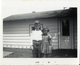
Bob and Colleen Rogers
https://search.heritageburnaby.ca/link/museumdescription21392
- Repository
- Burnaby Village Museum
- Date
- Jun. 1961
- Collection/Fonds
- Robert Rogers fonds
- Description Level
- Item
- Physical Description
- 1 photograph : b&w ; 8.5 x 6.5 cm
- Scope and Content
- Photograph of Robert "Bob" Rogers and sister Collen Rogers standing in the backyard of their house at 6458 Willingdon Avenue.
- Repository
- Burnaby Village Museum
- Collection/Fonds
- Robert Rogers fonds
- Description Level
- Item
- Physical Description
- 1 photograph : b&w ; 8.5 x 6.5 cm
- Scope and Content
- Photograph of Robert "Bob" Rogers and sister Collen Rogers standing in the backyard of their house at 6458 Willingdon Avenue.
- Geographic Access
- Willingdon Avenue
- Street Address
- 6458 Willingdon Avenue
- Accession Code
- BV024.8.6
- Access Restriction
- No restrictions
- Reproduction Restriction
- May be restricted by third party rights
- Date
- Jun. 1961
- Media Type
- Photograph
- Historic Neighbourhood
- Central Park (Historic Neighbourhood)
- Planning Study Area
- Maywood Area
- Scan Resolution
- 600
- Scan Date
- 2024-03-26
- Notes
- Title based on contents of photograph
- Date stamp on recto of photograph reads: "JUN_61"
- Note in black ink on verso of photograph reads:"BOB ROGERS & SISTER / COLLEEN ROGERS / TAKEN IN BACK YARD OF / 6458 WILLINGDON AVENUE"
Images
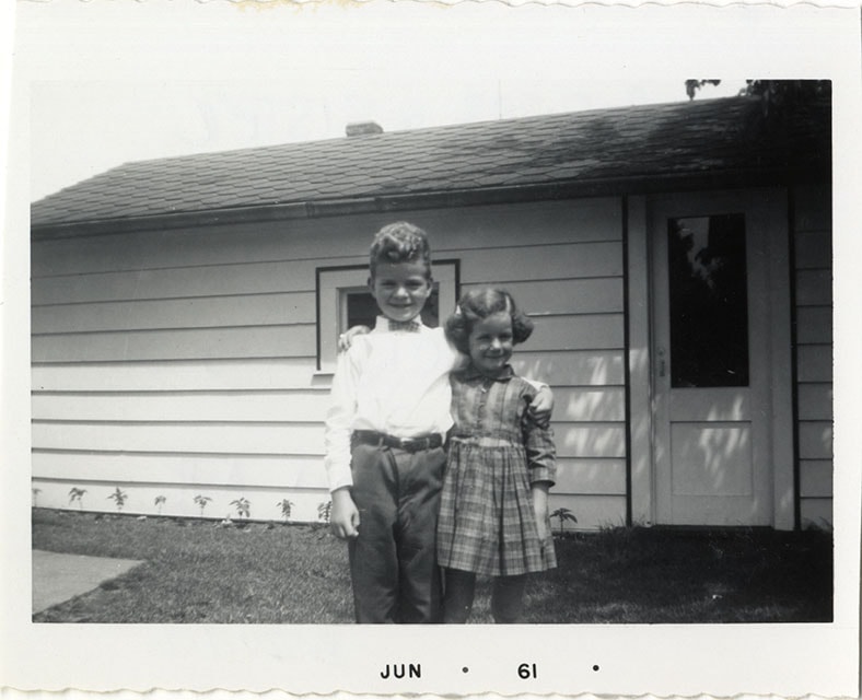
Bob and Colleen Rogers
https://search.heritageburnaby.ca/link/museumdescription21398
- Repository
- Burnaby Village Museum
- Collection/Fonds
- Robert Rogers fonds
- Description Level
- Item
- Physical Description
- 1 photograph : b&w ; 9 x 13 cm
- Scope and Content
- Photograph of Bob and Colleen Rogers standing in the backyard outside of their childhood family home located at 6458 Willingdon Avenue.
- Geographic Access
- Willingdon Avenue
- Street Address
- 6458 Willingdon Avenue
- Accession Code
- BV024.8.12
- Access Restriction
- No restrictions
- Reproduction Restriction
- May be restricted by third party rights
- Media Type
- Photograph
- Historic Neighbourhood
- Central Park (Historic Neighbourhood)
- Planning Study Area
- Maywood Area
- Scan Resolution
- 600
- Scan Date
- 2024-03-26
- Notes
- Title based on contents of photograph
- Note in black ink on verso of photograph reads: "BOB & COLLEEN ROGERS / TAKEN IN BACKYARD AT / 6458 WILLINGDON AVE."
Images

Burnaby's COVID-19 drive thru testing site
https://search.heritageburnaby.ca/link/museumdescription15374
- Repository
- Burnaby Village Museum
- Date
- 5 Apr. 2020
- Collection/Fonds
- Burnaby Village Museum COVID-19 collection
- Description Level
- Item
- Physical Description
- 1 photograph (jpg)
- Scope and Content
- Photograph of the COVID-19 drive thru testing site in Central Park parking lot in Burnaby. Orange traffic posts and wayfinding signs are set up in the parking lot.
- Repository
- Burnaby Village Museum
- Collection/Fonds
- Burnaby Village Museum COVID-19 collection
- Description Level
- Item
- Physical Description
- 1 photograph (jpg)
- Scope and Content
- Photograph of the COVID-19 drive thru testing site in Central Park parking lot in Burnaby. Orange traffic posts and wayfinding signs are set up in the parking lot.
- Subjects
- Advertising Medium - Signs and Signboards
- Geographic Features - Parks
- Public Services - Health Services
- Pandemics - COVID-19
- Geographic Access
- Central Park
- Imperial Street
- Accession Code
- BV021.2.39
- Access Restriction
- No restrictions
- Reproduction Restriction
- May be restricted by third party rights
- Date
- 5 Apr. 2020
- Media Type
- Photograph
- Historic Neighbourhood
- Central Park (Historic Neighbourhood)
- Planning Study Area
- Maywood Area
- Notes
- Title based on contents of photograph
Images


Burnaby's COVID-19 drive thru testing site
https://search.heritageburnaby.ca/link/museumdescription15375
- Repository
- Burnaby Village Museum
- Date
- 5 Apr. 2020
- Collection/Fonds
- Burnaby Village Museum COVID-19 collection
- Description Level
- Item
- Physical Description
- 1 photograph (jpg)
- Scope and Content
- Photograph of the COVID-19 drive thru testing site in Central Park parking lot in Burnaby. Orange traffic posts, wayfinding signs and white tents are set up in the parking lot.
- Repository
- Burnaby Village Museum
- Collection/Fonds
- Burnaby Village Museum COVID-19 collection
- Description Level
- Item
- Physical Description
- 1 photograph (jpg)
- Scope and Content
- Photograph of the COVID-19 drive thru testing site in Central Park parking lot in Burnaby. Orange traffic posts, wayfinding signs and white tents are set up in the parking lot.
- Subjects
- Advertising Medium - Signs and Signboards
- Geographic Features - Parks
- Public Services - Health Services
- Pandemics - COVID-19
- Geographic Access
- Central Park
- Imperial Street
- Accession Code
- BV021.2.40
- Access Restriction
- No restrictions
- Reproduction Restriction
- May be restricted by third party rights
- Date
- 5 Apr. 2020
- Media Type
- Photograph
- Historic Neighbourhood
- Central Park (Historic Neighbourhood)
- Planning Study Area
- Maywood Area
- Notes
- Title based on contents of photograph
Images


Burnaby's COVID-19 drive thru testing site
https://search.heritageburnaby.ca/link/museumdescription15376
- Repository
- Burnaby Village Museum
- Date
- 5 Apr. 2020
- Collection/Fonds
- Burnaby Village Museum COVID-19 collection
- Description Level
- Item
- Physical Description
- 1 photograph (jpg)
- Scope and Content
- Photograph of the COVID-19 drive thru testing site in Central Park parking lot in Burnaby. Orange traffic posts, wayfinding signs and white tents are set up in the parking lot.
- Repository
- Burnaby Village Museum
- Collection/Fonds
- Burnaby Village Museum COVID-19 collection
- Description Level
- Item
- Physical Description
- 1 photograph (jpg)
- Scope and Content
- Photograph of the COVID-19 drive thru testing site in Central Park parking lot in Burnaby. Orange traffic posts, wayfinding signs and white tents are set up in the parking lot.
- Subjects
- Advertising Medium - Signs and Signboards
- Geographic Features - Parks
- Public Services - Health Services
- Pandemics - COVID-19
- Geographic Access
- Central Park
- Imperial Street
- Accession Code
- BV021.2.41
- Access Restriction
- No restrictions
- Reproduction Restriction
- May be restricted by third party rights
- Date
- 5 Apr. 2020
- Media Type
- Photograph
- Historic Neighbourhood
- Central Park (Historic Neighbourhood)
- Planning Study Area
- Maywood Area
- Notes
- Title based on contents of photograph
Images


Burnaby's COVID-19 drive thru testing site
https://search.heritageburnaby.ca/link/museumdescription15377
- Repository
- Burnaby Village Museum
- Date
- 5 Apr. 2020
- Collection/Fonds
- Burnaby Village Museum COVID-19 collection
- Description Level
- Item
- Physical Description
- 1 photograph (jpg)
- Scope and Content
- Photograph of the COVID-19 drive thru testing site in Central Park parking lot in Burnaby. Orange traffic posts, wayfinding signs and white tents are set up in the parking lot.
- Repository
- Burnaby Village Museum
- Collection/Fonds
- Burnaby Village Museum COVID-19 collection
- Description Level
- Item
- Physical Description
- 1 photograph (jpg)
- Scope and Content
- Photograph of the COVID-19 drive thru testing site in Central Park parking lot in Burnaby. Orange traffic posts, wayfinding signs and white tents are set up in the parking lot.
- Subjects
- Advertising Medium - Signs and Signboards
- Geographic Features - Parks
- Public Services - Health Services
- Pandemics - COVID-19
- Geographic Access
- Central Park
- Imperial Street
- Accession Code
- BV021.2.42
- Access Restriction
- No restrictions
- Reproduction Restriction
- May be restricted by third party rights
- Date
- 5 Apr. 2020
- Media Type
- Photograph
- Historic Neighbourhood
- Central Park (Historic Neighbourhood)
- Planning Study Area
- Maywood Area
- Notes
- Title based on contents of photograph
Images


Burnaby's COVID-19 drive thru testing site
https://search.heritageburnaby.ca/link/museumdescription15378
- Repository
- Burnaby Village Museum
- Date
- 5 Apr. 2020
- Collection/Fonds
- Burnaby Village Museum COVID-19 collection
- Description Level
- Item
- Physical Description
- 1 photograph (jpg)
- Scope and Content
- Photograph of the COVID-19 drive thru testing site in Central Park parking lot in Burnaby. Orange traffic posts, wayfinding signs and white tents are set up in the parking lot.
- Repository
- Burnaby Village Museum
- Collection/Fonds
- Burnaby Village Museum COVID-19 collection
- Description Level
- Item
- Physical Description
- 1 photograph (jpg)
- Scope and Content
- Photograph of the COVID-19 drive thru testing site in Central Park parking lot in Burnaby. Orange traffic posts, wayfinding signs and white tents are set up in the parking lot.
- Subjects
- Advertising Medium - Signs and Signboards
- Geographic Features - Parks
- Public Services - Health Services
- Pandemics - COVID-19
- Geographic Access
- Central Park
- Imperial Street
- Accession Code
- BV021.2.43
- Access Restriction
- No restrictions
- Reproduction Restriction
- May be restricted by third party rights
- Date
- 5 Apr. 2020
- Media Type
- Photograph
- Historic Neighbourhood
- Central Park (Historic Neighbourhood)
- Planning Study Area
- Maywood Area
- Notes
- Title based on contents of photograph
Images


Burnaby's COVID-19 drive thru testing site
https://search.heritageburnaby.ca/link/museumdescription15379
- Repository
- Burnaby Village Museum
- Date
- 5 Apr. 2020
- Collection/Fonds
- Burnaby Village Museum COVID-19 collection
- Description Level
- Item
- Physical Description
- 1 photograph (jpg)
- Scope and Content
- Photograph of the COVID-19 drive thru testing site in Central Park parking lot in Burnaby. Orange traffic posts, wayfinding signs, white tents and white buildings converted from shipping containers are set up in the parking lot.
- Repository
- Burnaby Village Museum
- Collection/Fonds
- Burnaby Village Museum COVID-19 collection
- Description Level
- Item
- Physical Description
- 1 photograph (jpg)
- Scope and Content
- Photograph of the COVID-19 drive thru testing site in Central Park parking lot in Burnaby. Orange traffic posts, wayfinding signs, white tents and white buildings converted from shipping containers are set up in the parking lot.
- Subjects
- Advertising Medium - Signs and Signboards
- Geographic Features - Parks
- Public Services - Health Services
- Pandemics - COVID-19
- Geographic Access
- Central Park
- Imperial Street
- Accession Code
- BV021.2.44
- Access Restriction
- No restrictions
- Reproduction Restriction
- May be restricted by third party rights
- Date
- 5 Apr. 2020
- Media Type
- Photograph
- Historic Neighbourhood
- Central Park (Historic Neighbourhood)
- Planning Study Area
- Maywood Area
- Notes
- Title based on contents of photograph
Images


Burnaby's COVID-19 drive thru testing site
https://search.heritageburnaby.ca/link/museumdescription15380
- Repository
- Burnaby Village Museum
- Date
- 5 Apr. 2020
- Collection/Fonds
- Burnaby Village Museum COVID-19 collection
- Description Level
- Item
- Physical Description
- 1 photograph (jpg)
- Scope and Content
- Photograph of the COVID-19 drive thru testing site in Central Park parking lot in Burnaby. Orange traffic posts, wayfinding signs and white tents are set up in the parking lot.
- Repository
- Burnaby Village Museum
- Collection/Fonds
- Burnaby Village Museum COVID-19 collection
- Description Level
- Item
- Physical Description
- 1 photograph (jpg)
- Scope and Content
- Photograph of the COVID-19 drive thru testing site in Central Park parking lot in Burnaby. Orange traffic posts, wayfinding signs and white tents are set up in the parking lot.
- Subjects
- Advertising Medium - Signs and Signboards
- Geographic Features - Parks
- Public Services - Health Services
- Pandemics - COVID-19
- Geographic Access
- Central Park
- Imperial Street
- Accession Code
- BV021.2.45
- Access Restriction
- No restrictions
- Reproduction Restriction
- May be restricted by third party rights
- Date
- 5 Apr. 2020
- Media Type
- Photograph
- Historic Neighbourhood
- Central Park (Historic Neighbourhood)
- Planning Study Area
- Maywood Area
- Notes
- Title based on contents of photograph
Images


Burnaby's COVID-19 drive thru testing site
https://search.heritageburnaby.ca/link/museumdescription15381
- Repository
- Burnaby Village Museum
- Date
- 5 Apr. 2020
- Collection/Fonds
- Burnaby Village Museum COVID-19 collection
- Description Level
- Item
- Physical Description
- 1 photograph (jpg)
- Scope and Content
- Photograph of the COVID-19 drive thru testing site in Central Park parking lot in Burnaby. Orange traffic posts, wayfinding signs and white tents are set up in the parking lot.
- Repository
- Burnaby Village Museum
- Collection/Fonds
- Burnaby Village Museum COVID-19 collection
- Description Level
- Item
- Physical Description
- 1 photograph (jpg)
- Scope and Content
- Photograph of the COVID-19 drive thru testing site in Central Park parking lot in Burnaby. Orange traffic posts, wayfinding signs and white tents are set up in the parking lot.
- Subjects
- Advertising Medium - Signs and Signboards
- Geographic Features - Parks
- Public Services - Health Services
- Pandemics - COVID-19
- Geographic Access
- Central Park
- Imperial Street
- Accession Code
- BV021.2.46
- Access Restriction
- No restrictions
- Reproduction Restriction
- May be restricted by third party rights
- Date
- 5 Apr. 2020
- Media Type
- Photograph
- Historic Neighbourhood
- Central Park (Historic Neighbourhood)
- Planning Study Area
- Maywood Area
- Notes
- Title based on contents of photograph
Images


Burnaby's COVID-19 drive thru testing site
https://search.heritageburnaby.ca/link/museumdescription15382
- Repository
- Burnaby Village Museum
- Date
- 5 Apr. 2020
- Collection/Fonds
- Burnaby Village Museum COVID-19 collection
- Description Level
- Item
- Physical Description
- 1 photograph (jpg)
- Scope and Content
- Photograph of the COVID-19 drive thru testing site in Central Park parking lot in Burnaby. White shipping container buildings have been set up in the parking lot.
- Repository
- Burnaby Village Museum
- Collection/Fonds
- Burnaby Village Museum COVID-19 collection
- Description Level
- Item
- Physical Description
- 1 photograph (jpg)
- Scope and Content
- Photograph of the COVID-19 drive thru testing site in Central Park parking lot in Burnaby. White shipping container buildings have been set up in the parking lot.
- Subjects
- Advertising Medium - Signs and Signboards
- Geographic Features - Parks
- Public Services - Health Services
- Pandemics - COVID-19
- Geographic Access
- Central Park
- Imperial Street
- Accession Code
- BV021.2.47
- Access Restriction
- No restrictions
- Reproduction Restriction
- May be restricted by third party rights
- Date
- 5 Apr. 2020
- Media Type
- Photograph
- Historic Neighbourhood
- Central Park (Historic Neighbourhood)
- Planning Study Area
- Maywood Area
- Notes
- Title based on contents of photograph
Images


Burnaby's COVID-19 drive thru testing site
https://search.heritageburnaby.ca/link/museumdescription15383
- Repository
- Burnaby Village Museum
- Date
- 5 Apr. 2020
- Collection/Fonds
- Burnaby Village Museum COVID-19 collection
- Description Level
- Item
- Physical Description
- 1 photograph (jpg)
- Scope and Content
- Photograph of the COVID-19 drive thru testing site in Central Park parking lot in Burnaby. White shipping container buildings have been set up in the parking lot.
- Repository
- Burnaby Village Museum
- Collection/Fonds
- Burnaby Village Museum COVID-19 collection
- Description Level
- Item
- Physical Description
- 1 photograph (jpg)
- Scope and Content
- Photograph of the COVID-19 drive thru testing site in Central Park parking lot in Burnaby. White shipping container buildings have been set up in the parking lot.
- Subjects
- Advertising Medium - Signs and Signboards
- Geographic Features - Parks
- Public Services - Health Services
- Pandemics - COVID-19
- Geographic Access
- Central Park
- Imperial Street
- Accession Code
- BV021.2.48
- Access Restriction
- No restrictions
- Reproduction Restriction
- May be restricted by third party rights
- Date
- 5 Apr. 2020
- Media Type
- Photograph
- Historic Neighbourhood
- Central Park (Historic Neighbourhood)
- Planning Study Area
- Maywood Area
- Notes
- Title based on contents of photograph
Images


Burnaby's COVID-19 drive thru testing site
https://search.heritageburnaby.ca/link/museumdescription15391
- Repository
- Burnaby Village Museum
- Date
- 27 Apr. 2020
- Collection/Fonds
- Burnaby Village Museum COVID-19 collection
- Description Level
- Item
- Physical Description
- 1 video recording (mp4) (17 sec.) : digital, 24 fps, col., si.
- Scope and Content
- Film clip (no sound) of the COVID-19 drive thru testing site in Central Park parking lot in Burnaby. Orange traffic posts, wayfinding signs and white tents are set up in the parking lot and staff are wearing protective face masks.
- Repository
- Burnaby Village Museum
- Collection/Fonds
- Burnaby Village Museum COVID-19 collection
- Description Level
- Item
- Physical Description
- 1 video recording (mp4) (17 sec.) : digital, 24 fps, col., si.
- Scope and Content
- Film clip (no sound) of the COVID-19 drive thru testing site in Central Park parking lot in Burnaby. Orange traffic posts, wayfinding signs and white tents are set up in the parking lot and staff are wearing protective face masks.
- Subjects
- Advertising Medium - Signs and Signboards
- Geographic Features - Parks
- Public Services - Health Services
- Pandemics - COVID-19
- Geographic Access
- Central Park
- Imperial Street
- Accession Code
- BV021.2.8
- Access Restriction
- No restrictions
- Reproduction Restriction
- May be restricted by third party rights
- Date
- 27 Apr. 2020
- Media Type
- Moving Images
- Historic Neighbourhood
- Central Park (Historic Neighbourhood)
- Planning Study Area
- Maywood Area
- Notes
- Title based on contents of photograph
Images

Video
Burnaby's COVID-19 drive thru testing site, 27 Apr. 2020
Burnaby's COVID-19 drive thru testing site, 27 Apr. 2020
https://search.heritageburnaby.ca/media/hpo/_Data/_BVM_Moving_Images/2021_0002_0008_001.mp4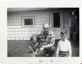
Charlie Rogers with Bob and Colleen Rogers
https://search.heritageburnaby.ca/link/museumdescription21395
- Repository
- Burnaby Village Museum
- Date
- Jun. 1961
- Collection/Fonds
- Robert Rogers fonds
- Description Level
- Item
- Physical Description
- 1 photograph : b&w ; 7 x 9 cm
- Scope and Content
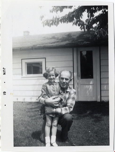
- Photograph of Laurence "Charlie" Rogers with his children, Colleen and Bob Rogers in the backyard of their home at 6458 Willingdon Avenue.
- Repository
- Burnaby Village Museum
- Collection/Fonds
- Robert Rogers fonds
- Description Level
- Item
- Physical Description
- 1 photograph : b&w ; 7 x 9 cm
- Scope and Content
- Photograph of Laurence "Charlie" Rogers with his children, Colleen and Bob Rogers in the backyard of their home at 6458 Willingdon Avenue.
- Geographic Access
- Willingdon Avenue
- Street Address
- 6458 Willingdon Avenue
- Accession Code
- BV024.8.9
- Access Restriction
- No restrictions
- Reproduction Restriction
- May be restricted by third party rights
- Date
- Jun. 1961
- Media Type
- Photograph
- Historic Neighbourhood
- Central Park (Historic Neighbourhood)
- Planning Study Area
- Maywood Area
- Scan Resolution
- 600
- Scan Date
- 2024-03-26
- Notes
- Title based on contents of photograph
- Date stamp on recto of photograph reads: "JUN_61"
- Note in black ink on verso of photograph reads:"COLLEEN ROGERS, CHARLIE / ROGERS & BOB ROGERS AT / 6458 WILLINGDON AVENUE"
Images

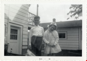
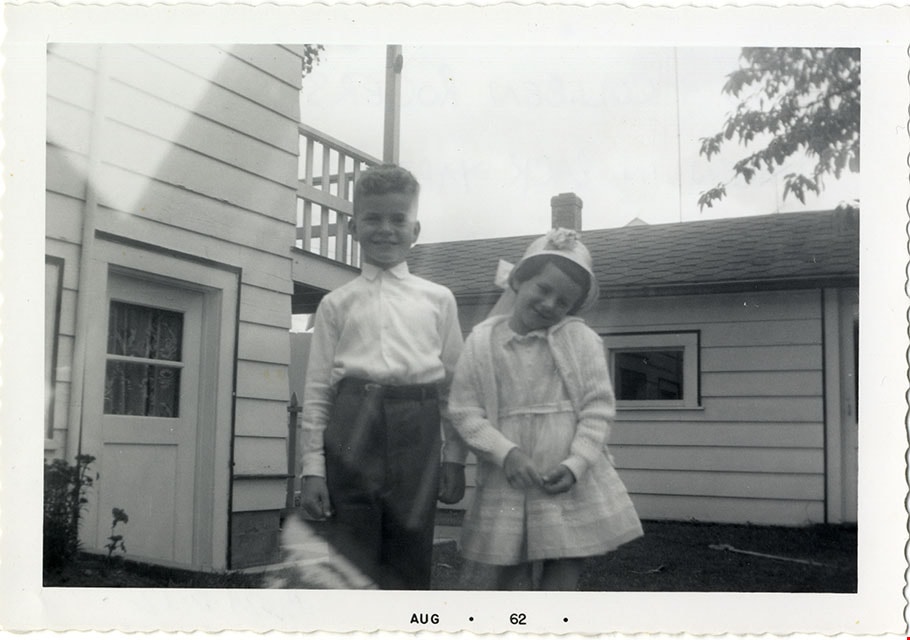
Charlie Rogers with daughter Colleen
https://search.heritageburnaby.ca/link/museumdescription21393
- Repository
- Burnaby Village Museum
- Date
- Aug. 1961
- Collection/Fonds
- Robert Rogers fonds
- Description Level
- Item
- Physical Description
- 1 photograph : b&w ; 8.5 x 7 cm
- Scope and Content
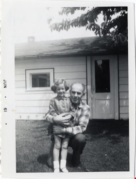
- Photograph of Charlie Rogers with his young daughter, Colleeen Rogers in the backyard of their home at 6458 Willingdon Avenue.
- Repository
- Burnaby Village Museum
- Collection/Fonds
- Robert Rogers fonds
- Description Level
- Item
- Physical Description
- 1 photograph : b&w ; 8.5 x 7 cm
- Scope and Content
- Photograph of Charlie Rogers with his young daughter, Colleeen Rogers in the backyard of their home at 6458 Willingdon Avenue.
- Geographic Access
- Willingdon Avenue
- Street Address
- 6458 Willingdon Avenue
- Accession Code
- BV024.8.7
- Access Restriction
- No restrictions
- Reproduction Restriction
- May be restricted by third party rights
- Date
- Aug. 1961
- Media Type
- Photograph
- Historic Neighbourhood
- Central Park (Historic Neighbourhood)
- Planning Study Area
- Maywood Area
- Scan Resolution
- 600
- Scan Date
- 2024-03-26
- Notes
- Title based on contents of photograph
- Date stamp on recto of photograph reads: "JUN_61"
- Note in black ink on verso of photograph reads:"COLLEEN ROGERS AND / DAD, CHARLIE ROGERS / IN BACKYARD OF / OUR HOUSE AT / 6458 WILLINGDON AVENUE"
Images

Coe family house
https://search.heritageburnaby.ca/link/museumdescription3130
- Repository
- Burnaby Village Museum
- Date
- July 1965
- Collection/Fonds
- Burnaby Village Museum Photograph collection
- Description Level
- Item
- Physical Description
- 1 photograph : col. slide (Kodachrome) ; 2.5 x 3.5 cm
- Scope and Content
- Photograph of the northeast portion of the Coe family house at 2684 (renumbered in the 6300 block) Fern Avenue. The house is two stories high with front steps that lead up to a large veranda.
- Repository
- Burnaby Village Museum
- Collection/Fonds
- Burnaby Village Museum Photograph collection
- Description Level
- Item
- Physical Description
- 1 photograph : col. slide (Kodachrome) ; 2.5 x 3.5 cm
- Scope and Content
- Photograph of the northeast portion of the Coe family house at 2684 (renumbered in the 6300 block) Fern Avenue. The house is two stories high with front steps that lead up to a large veranda.
- Subjects
- Buildings - Residential - Houses
- Geographic Access
- Fern Avenue
- Accession Code
- BV995.13.2
- Access Restriction
- Restricted access
- Reproduction Restriction
- May be restricted by third party rights
- Date
- July 1965
- Media Type
- Photograph
- Historic Neighbourhood
- Central Park (Historic Neighbourhood)
- Planning Study Area
- Marlborough Area
- Scan Resolution
- 600
- Scan Date
- 07-May-24
- Notes
- Title based on contents of photograph
- Note on recto of slide mount reads: "COE Residence/ North East View / Fern Ave Burnaby"
- Date stamp on recto of slide mount reads: "JUL 65V."
Images


Coe family house
https://search.heritageburnaby.ca/link/museumdescription3131
- Repository
- Burnaby Village Museum
- Date
- July 1965
- Collection/Fonds
- Burnaby Village Museum Photograph collection
- Description Level
- Item
- Physical Description
- 1 photograph : col. slide (Kodachrome) ; 2.5 x 3.5 cm
- Scope and Content
- Photograph of the southeast portion of the Coe family house at 2684 (renumbered in the 6300 block) Fern Avenue. The house is two stories high with front steps that lead up to a large veranda.
- Repository
- Burnaby Village Museum
- Collection/Fonds
- Burnaby Village Museum Photograph collection
- Description Level
- Item
- Physical Description
- 1 photograph : col. slide (Kodachrome) ; 2.5 x 3.5 cm
- Scope and Content
- Photograph of the southeast portion of the Coe family house at 2684 (renumbered in the 6300 block) Fern Avenue. The house is two stories high with front steps that lead up to a large veranda.
- Subjects
- Buildings - Residential - Houses
- Geographic Access
- Fern Avenue
- Accession Code
- BV995.13.3
- Access Restriction
- Restricted access
- Reproduction Restriction
- May be restricted by third party rights
- Date
- July 1965
- Media Type
- Photograph
- Historic Neighbourhood
- Central Park (Historic Neighbourhood)
- Planning Study Area
- Marlborough Area
- Scan Resolution
- 600
- Scan Date
- 07-May-24
- Notes
- Title based on contents of photograph
- Note on recto of slide mount reads: "COE Residence/ South East View / Fern Ave Burnaby"
- Date stamp on recto of slide mount reads: "JUL 65V."
Images


Coe family house
https://search.heritageburnaby.ca/link/museumdescription3132
- Repository
- Burnaby Village Museum
- Date
- July 1965
- Collection/Fonds
- Burnaby Village Museum Photograph collection
- Description Level
- Item
- Physical Description
- 1 photograph : col. slide (Kodachrome) ; 2.5 x 3.5 cm
- Scope and Content
- Photograph of the southwest portion of the Coe family house at 2684 (renumbered in the 6300 block) Fern Avenue. The house is two stories high with front steps that lead up to a large veranda.
- Repository
- Burnaby Village Museum
- Collection/Fonds
- Burnaby Village Museum Photograph collection
- Description Level
- Item
- Physical Description
- 1 photograph : col. slide (Kodachrome) ; 2.5 x 3.5 cm
- Scope and Content
- Photograph of the southwest portion of the Coe family house at 2684 (renumbered in the 6300 block) Fern Avenue. The house is two stories high with front steps that lead up to a large veranda.
- Subjects
- Buildings - Residential - Houses
- Geographic Access
- Fern Avenue
- Accession Code
- BV995.13.4
- Access Restriction
- Restricted access
- Reproduction Restriction
- May be restricted by third party rights
- Date
- July 1965
- Media Type
- Photograph
- Historic Neighbourhood
- Central Park (Historic Neighbourhood)
- Planning Study Area
- Marlborough Area
- Scan Resolution
- 600
- Scan Date
- 07-May-24
- Notes
- Title based on contents of photograph
- Note on recto of slide mount reads: "COE Residence/ South West View / Fern Ave Burnaby"
- Date stamp on recto of slide mount reads: "JUL 65V."
Images

![Colleen, Bob and Edith Rogers with two women, [between 1959 and 1961] thumbnail](/media/hpo/_Data/_BVM_Images/2024/2024_0008_0011_001.jpg?width=280)
Colleen, Bob and Edith Rogers with two women
https://search.heritageburnaby.ca/link/museumdescription21397
- Repository
- Burnaby Village Museum
- Date
- [between 1959 and 1961]
- Collection/Fonds
- Robert Rogers fonds
- Description Level
- Item
- Physical Description
- 1 photograph : b&w ; 13 x 9 cm
- Scope and Content
- Photograph of Colleen and Bob Rogers (in front) standing together with Mary Steele (left), their grandmother Edith Rogers and Mabel McKenzie (far right). The group are standing beneath a cherry tree in the backyard of the home of Charlie and Ethel Rogers at 6458 Willingdon Avenue.
- Repository
- Burnaby Village Museum
- Collection/Fonds
- Robert Rogers fonds
- Description Level
- Item
- Physical Description
- 1 photograph : b&w ; 13 x 9 cm
- Scope and Content
- Photograph of Colleen and Bob Rogers (in front) standing together with Mary Steele (left), their grandmother Edith Rogers and Mabel McKenzie (far right). The group are standing beneath a cherry tree in the backyard of the home of Charlie and Ethel Rogers at 6458 Willingdon Avenue.
- Names
- Rogers, Colleen
- Rogers, Robert "Bob"
- Rogers, Edith Eleanor Trimmer
- Steele, Mary Gibson
- McKenzie, Mabel Steel
- Geographic Access
- Willingdon Avenue
- Street Address
- 6458 Willingdon Avenue
- Accession Code
- BV024.8.11
- Access Restriction
- No restrictions
- Reproduction Restriction
- May be restricted by third party rights
- Date
- [between 1959 and 1961]
- Media Type
- Photograph
- Historic Neighbourhood
- Central Park (Historic Neighbourhood)
- Planning Study Area
- Maywood Area
- Scan Resolution
- 600
- Scan Date
- 2024-03-26
- Notes
- Title based on contents of photograph
- Note in black ink on verso of photograph reads: "FRONT ROW: COLLEEN ROGERS / BOB ROGERS / BACK ROW: OUR GRANDMOTHER, / EDITH ROGERS IN CENTER. / MARY STEELE WITH HANDON COLLEEN'S SHOULDERE. OTHER / LADY MABEL MCKENZIE. / LARGE CHERRY TREE IN BACK / YARD OF 6458 WILLINGDON"
Images
![Colleen, Bob and Edith Rogers with two women, [between 1959 and 1961] thumbnail](/media/hpo/_Data/_BVM_Images/2024/2024_0008_0011_001.jpg)
![Digney film 1 - Playing badminton, [1960] (date of original), copied 2019 thumbnail](/media/hpo/_Data/_BVM_Moving_Images/2019_0018_0003_012.jpg?width=280)
Digney film 1 - Playing badminton
https://search.heritageburnaby.ca/link/museumdescription10615
- Repository
- Burnaby Village Museum
- Date
- [1960] (date of original), copied 2019
- Collection/Fonds
- Digney Family fonds
- Description Level
- Item
- Physical Description
- 1 video recording (mp4) (53 sec.) : digital, 23 fps, col., si.
- Scope and Content
- Film segment taken from the front yard of Digney home at 6521 Bonsor Street. Joyce Digney is in the front yard playing badminton with her son Bruce while son Paul Digney is holding a hose and filling a pool in the driveway. Bonsor Park can be seen across the road along with houses.
- Repository
- Burnaby Village Museum
- Collection/Fonds
- Digney Family fonds
- Description Level
- Item
- Physical Description
- 1 video recording (mp4) (53 sec.) : digital, 23 fps, col., si.
- Scope and Content
- Film segment taken from the front yard of Digney home at 6521 Bonsor Street. Joyce Digney is in the front yard playing badminton with her son Bruce while son Paul Digney is holding a hose and filling a pool in the driveway. Bonsor Park can be seen across the road along with houses.
- Creator
- Digney, Andy
- Subjects
- Sports - Badminton
- Geographic Access
- Bonsor Avenue
- Street Address
- 6521 Bonsor Avenue
- Accession Code
- BV019.18.3.12
- Access Restriction
- No restrictions
- Reproduction Restriction
- No known restrictions
- Date
- [1960] (date of original), copied 2019
- Media Type
- Moving Images
- Historic Neighbourhood
- Central Park (Historic Neighbourhood)
- Planning Study Area
- Maywood Area
- Photographer
- Digney, Ernest Frank "Dig"
- Notes
- Title based on contents of film segment
- Film segment originates from digitized version of original 8 mm film (See BV019.18.3)
Images
![Digney film 1 - Playing badminton, [1960] (date of original), copied 2019 thumbnail](/media/hpo/_Data/_BVM_Moving_Images/2019_0018_0003_012.jpg)
Video
Digney film 1 - Playing badminton, [1960] (date of original), copied 2019
Digney film 1 - Playing badminton, [1960] (date of original), copied 2019
https://search.heritageburnaby.ca/media/hpo/_Data/_BVM_Moving_Images/2019_0018_0003_012.mp4