Narrow Results By
In the shadow by the sea : recollections of Burnaby's Barnet Village
https://search.heritageburnaby.ca/link/museumlibrary5173
- Repository
- Burnaby Village Museum
- Publication Date
- c2004
- Call Number
- 971.133 PRI Copy 2
Burrard
Inlet to the mill.
An experienced mill man will be struck
immediately by the general economy of
labor due to the mechanical devices which
take the place ofmanual labor in many of
the less modern plants. Insteadofthe usual
Oriental, who carries away the waste ma-
terial in a cart or basket
- Repository
- Burnaby Village Museum
- Collection
- Digital Reference Collection
- Reference Collection
- Material Type
- Book
- ISBN
- 0969282885
- Call Number
- 971.133 PRI Copy 2
- Contributor
- Wolf, Jim
- Pride, Harry, 1925-
- Place of Publication
- Burnaby, B.C.
- Publisher
- City of Burnaby
- Publication Date
- c2004
- Physical Description
- 246 p. : ill., maps, ports. ; 28 cm.
- Library Subject (LOC)
- Burnaby (B.C.)--History
- Industries--British Columbia--Burnaby--History
- Barnet Marine Park--Burnaby, B.C.
- Geographic Access
- Barnet Road
- Burrard Inlet
- Notes
- Includes bibliographical references (p. 246) and index.
- "edited by Harry Pride and Jim Wolf"
- Copy 2 of 2
Digital Books
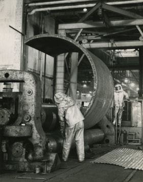
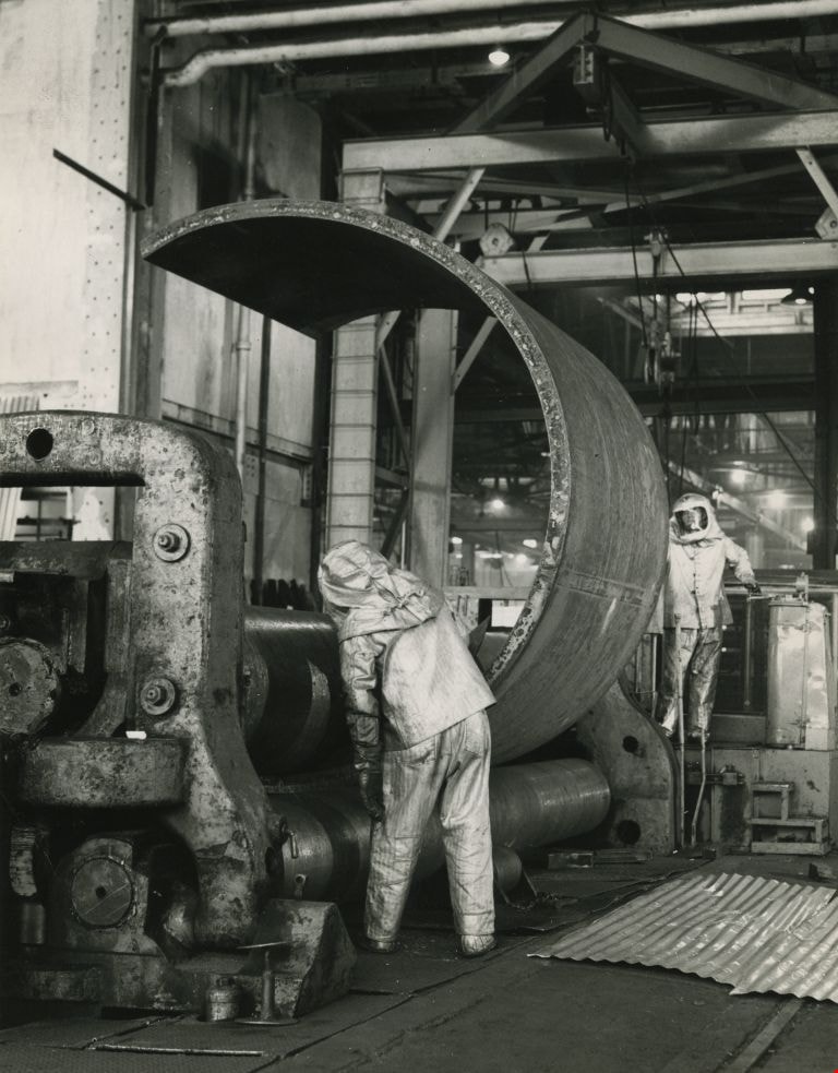
Working at the Dominion Bridge Co.'s Burnaby plant
https://search.heritageburnaby.ca/link/archivedescription45613
- Repository
- City of Burnaby Archives
- Date
- April 1966, published April 18, 1966
- Collection/Fonds
- Columbian Newspaper collection
- Description Level
- Item
- Physical Description
- 1 photograph : b&w ; 24 x 18.5 cm
- Scope and Content
- Photograph of workmen at the Dominion Bridge Co.'s Burnaby plant. They are feeding a flat steel plate, more than three inches think inot a pyramind roll for fabrication in the making of a sulfinol vessel for the petroleum industry in Alberta. The workmen are wearing asbestos aluminum suits to withs…
- Repository
- City of Burnaby Archives
- Date
- April 1966, published April 18, 1966
- Collection/Fonds
- Columbian Newspaper collection
- Physical Description
- 1 photograph : b&w ; 24 x 18.5 cm
- Description Level
- Item
- Record No.
- 480-507
- Access Restriction
- No restrictions
- Reproduction Restriction
- Reproduce for fair dealing purposes only
- Accession Number
- 2003-02
- Scope and Content
- Photograph of workmen at the Dominion Bridge Co.'s Burnaby plant. They are feeding a flat steel plate, more than three inches think inot a pyramind roll for fabrication in the making of a sulfinol vessel for the petroleum industry in Alberta. The workmen are wearing asbestos aluminum suits to withstand the intense heat reflected from the heated plate (the plate was heated in a furnace before being fed into the pyramid roll).
- Names
- Dominion Bridge Company
- Media Type
- Photograph
- Photographer
- Henry Tregillas Photography Ltd.
- Notes
- Title based on contents of photograph
- Geographic Access
- Boundary Road
- Street Address
- 2400 Boundary Road
- Historic Neighbourhood
- Broadview (Historic Neighbourhood)
- Planning Study Area
- West Central Valley Area
Images

Nichols Chemical Co. Ltd. - Drawing No. 511726
https://search.heritageburnaby.ca/link/museumdescription11393
- Repository
- Burnaby Village Museum
- Date
- 26 Jan. 1962
- Collection/Fonds
- Nichols Chemical Company fonds
- Description Level
- Item
- Physical Description
- 1 technical drawing : blueline print ; 87.5 x 111 cm
- Scope and Content
- Item consists of technical drawing titled "Assy. Det. No. 3 Ore Burner", "No. 511726" of Nichol's Chemical Plant. Includes "Parts Lists" index.
- Repository
- Burnaby Village Museum
- Collection/Fonds
- Nichols Chemical Company fonds
- Description Level
- Item
- Physical Description
- 1 technical drawing : blueline print ; 87.5 x 111 cm
- Material Details
- Scale 1:.25
- Scope and Content
- Item consists of technical drawing titled "Assy. Det. No. 3 Ore Burner", "No. 511726" of Nichol's Chemical Plant. Includes "Parts Lists" index.
- Subjects
- Buildings - Industrial - Factories
- Responsibility
- General Chemical Company
- Geographic Access
- Barnet Road
- Street Address
- 8655 Barnet Road
- Accession Code
- BV998.23.15
- Access Restriction
- No restrictions
- Reproduction Restriction
- No known restrictions
- Date
- 26 Jan. 1962
- Media Type
- Technical Drawing
- Historic Neighbourhood
- Barnet (Historic Neighbourhood)
- Planning Study Area
- Burnaby Mountain Area
- Scan Resolution
- 300
- Scan Date
- 2022-05-10
- Notes
- Title based on contents of item
- "Scale 1/4" = 1'
- Stamped with Print Date: "Jan 26 1962"
Images

![Pond at former Barnet Rifle Range, [2000] thumbnail](/media/hpo/_Data/_Archives_Images/_Unrestricted/535/535-2629.jpg?width=280)
Pond at former Barnet Rifle Range
https://search.heritageburnaby.ca/link/archivedescription97102
- Repository
- City of Burnaby Archives
- Date
- [2000]
- Collection/Fonds
- Burnaby NewsLeader photograph collection
- Description Level
- Item
- Physical Description
- 1 photograph (tiff) : col.
- Scope and Content
- Photograph of Dipak Datlami next to the pond at the former Barnet Rifle Range that was created to settle out contaminants from the site heading for Simon Creek. The pond is surrounded by tall grasses and forest in the background.
- Repository
- City of Burnaby Archives
- Date
- [2000]
- Collection/Fonds
- Burnaby NewsLeader photograph collection
- Physical Description
- 1 photograph (tiff) : col.
- Description Level
- Item
- Record No.
- 535-2629
- Access Restriction
- No restrictions
- Reproduction Restriction
- No restrictions
- Accession Number
- 2018-12
- Scope and Content
- Photograph of Dipak Datlami next to the pond at the former Barnet Rifle Range that was created to settle out contaminants from the site heading for Simon Creek. The pond is surrounded by tall grasses and forest in the background.
- Names
- Barnet Rifle Club
- Media Type
- Photograph
- Photographer
- Bartel, Mario
- Notes
- Title based on caption
- Collected by editorial for use in a July 2000 issue of the Burnaby NewsLeader
- Caption from metadata: "Dipak Datlami looks out over a pond at the former Barnet Rifle Range, created to settle out solid contaminants from the site heading for Simon Creek. The tall grasses around the pond were also hydro-planted to prevent contaminated soil from migrating."
- Geographic Access
- Barnet Road
- Street Address
- 8550 Barnet Road
- Historic Neighbourhood
- Barnet (Historic Neighbourhood)
- Planning Study Area
- Burnaby Mountain Area
Images
![Pond at former Barnet Rifle Range, [2000] thumbnail](/media/hpo/_Data/_Archives_Images/_Unrestricted/535/535-2629.jpg)