Narrow Results By
Subject
- Accidents - Automobile Accidents 1
- Advertising Medium 2
- Advertising Medium - Signs and Signboards 8
- Aerial Photographs
- Agricultural Tools and Equipment 1
- Agriculture - Farms 23
- Agriculture - Fruit and Berries 3
- Animals - Birds 1
- Animals - Dogs
- Animals - Horses 14
- Animals - Poultry 1
- Arts - Paintings 1
Aerial photograph of Burnaby Mountain
https://search.heritageburnaby.ca/link/archivedescription64460
- Repository
- City of Burnaby Archives
- Date
- [1957 or 1958]
- Collection/Fonds
- Burnaby Historical Society fonds
- Description Level
- Item
- Physical Description
- 1 photograph : b&w ; 14 x 14 cm
- Scope and Content
- Aerial photograph of the Burnaby Mountain park and Centennial Pavilion, under construction.
- Repository
- City of Burnaby Archives
- Date
- [1957 or 1958]
- Collection/Fonds
- Burnaby Historical Society fonds
- Subseries
- North Burnaby Board of Trade subseries
- Physical Description
- 1 photograph : b&w ; 14 x 14 cm
- Description Level
- Item
- Record No.
- 476-026
- Access Restriction
- No restrictions
- Reproduction Restriction
- Reproduce for fair dealing purposes only
- Accession Number
- BHS2005-8
- Scope and Content
- Aerial photograph of the Burnaby Mountain park and Centennial Pavilion, under construction.
- Subjects
- Aerial Photographs
- Land Clearing
- Media Type
- Photograph
- Photographer
- Hunting Survey Corporation Limited
- Notes
- Title based on contents of photograph
- Geographic Access
- Burnaby Mountain Conservation Area
- Centennial Way
- Street Address
- 100 Centennial Way
- Planning Study Area
- Burnaby Mountain Area
![Aerial photograph of Burnaby Mountain, [1957 or 1958] thumbnail](/media/hpo/_Data/_Archives_Images/_Unrestricted/371/476-024.jpg?width=280)
Aerial photograph of Burnaby Mountain
https://search.heritageburnaby.ca/link/archivedescription38681
- Repository
- City of Burnaby Archives
- Date
- [1957 or 1958]
- Collection/Fonds
- Burnaby Historical Society fonds
- Description Level
- Item
- Physical Description
- 1 photograph : b&w ; 19 x 24 cm
- Scope and Content
- Aerial photograph of Burnaby Mountain and the Centennial Pavilion, built to mark the 1958 centennial.
- Repository
- City of Burnaby Archives
- Date
- [1957 or 1958]
- Collection/Fonds
- Burnaby Historical Society fonds
- Subseries
- North Burnaby Board of Trade subseries
- Physical Description
- 1 photograph : b&w ; 19 x 24 cm
- Description Level
- Item
- Record No.
- 476-024
- Access Restriction
- No restrictions
- Reproduction Restriction
- Reproduce for fair dealing purposes only
- Accession Number
- BHS2005-8
- Scope and Content
- Aerial photograph of Burnaby Mountain and the Centennial Pavilion, built to mark the 1958 centennial.
- Subjects
- Aerial Photographs
- Media Type
- Photograph
- Photographer
- Rossmo, Nicholas
- Notes
- Title based on contents of photograph
- Geographic Access
- Burnaby Mountain Conservation Area
- Centennial Way
- Street Address
- 100 Centennial Way
- Planning Study Area
- Burnaby Mountain Area
Images
![Aerial photograph of Burnaby Mountain, [1957 or 1958] thumbnail](/media/hpo/_Data/_Archives_Images/_Unrestricted/371/476-024.jpg)
![Aerial photograph of Burnaby Mountain, [1957 or 1958] thumbnail](/media/hpo/_Data/_Archives_Images/_Unrestricted/371/476-025.jpg?width=280)
Aerial photograph of Burnaby Mountain
https://search.heritageburnaby.ca/link/archivedescription39742
- Repository
- City of Burnaby Archives
- Date
- [1957 or 1958]
- Collection/Fonds
- Burnaby Historical Society fonds
- Description Level
- Item
- Physical Description
- 1 photograph : b&w ; 14 x 14 cm
- Scope and Content
- Aerial photograph of the Burnaby Mountain park and Centennial Pavilion, under construction.
- Repository
- City of Burnaby Archives
- Date
- [1957 or 1958]
- Collection/Fonds
- Burnaby Historical Society fonds
- Subseries
- North Burnaby Board of Trade subseries
- Physical Description
- 1 photograph : b&w ; 14 x 14 cm
- Description Level
- Item
- Record No.
- 476-025
- Access Restriction
- No restrictions
- Reproduction Restriction
- Reproduce for fair dealing purposes only
- Accession Number
- BHS2005-8
- Scope and Content
- Aerial photograph of the Burnaby Mountain park and Centennial Pavilion, under construction.
- Subjects
- Aerial Photographs
- Land Clearing
- Media Type
- Photograph
- Photographer
- Hunting Survey Corporation Limited
- Notes
- Title based on contents of photograph.
- Geographic Access
- Burnaby Mountain Conservation Area
- Centennial Way
- Street Address
- 100 Centennial Way
- Planning Study Area
- Burnaby Mountain Area
Images
![Aerial photograph of Burnaby Mountain, [1957 or 1958] thumbnail](/media/hpo/_Data/_Archives_Images/_Unrestricted/371/476-025.jpg)

Aerial photograph of Grandview Highway
https://search.heritageburnaby.ca/link/archivedescription37876
- Repository
- City of Burnaby Archives
- Date
- July 1952 (date of original), copied 1991
- Collection/Fonds
- Burnaby Historical Society fonds
- Description Level
- Item
- Physical Description
- 1 photograph : b&w ; 3.4 x 4.3 cm print on contact sheet 20.1 x 26.7 cm
- Scope and Content
- Aerial photograph of Cascade Drive-In Theatre at 4050 Grandview Highway and the surrounding area. Note: Burnaby General Hospital under construction can be seen on the left.
- Repository
- City of Burnaby Archives
- Date
- July 1952 (date of original), copied 1991
- Collection/Fonds
- Burnaby Historical Society fonds
- Subseries
- Burnaby Image Bank subseries
- Physical Description
- 1 photograph : b&w ; 3.4 x 4.3 cm print on contact sheet 20.1 x 26.7 cm
- Description Level
- Item
- Record No.
- 370-464
- Access Restriction
- No restrictions
- Reproduction Restriction
- No restrictions
- Accession Number
- BHS1999-03
- Scope and Content
- Aerial photograph of Cascade Drive-In Theatre at 4050 Grandview Highway and the surrounding area. Note: Burnaby General Hospital under construction can be seen on the left.
- Subjects
- Aerial Photographs
- Media Type
- Photograph
- Photographer
- Cunningham, W.
- Notes
- Title based on contents of photograph
- 1 b&w copy negative accompanying
- Negative has a pink cast
- Geographic Access
- Grandview Highway
- Street Address
- 4050 Grandview Highway
- Historic Neighbourhood
- Broadview (Historic Neighbourhood)
- Planning Study Area
- Cascade-Schou Area
- West Central Valley Area
Images


Aerial photograph of Timber Preservers Ltd.
https://search.heritageburnaby.ca/link/archivedescription34686
- Repository
- City of Burnaby Archives
- Date
- 1957
- Collection/Fonds
- Burnaby Historical Society fonds
- Description Level
- Item
- Physical Description
- 1 photograph : b&w ; 20.2 x 24.8 cm
- Scope and Content
- Aerial photograph of Timber Preservers Ltd. and the Fraser River at the foot of Trapp Avenue.
- Repository
- City of Burnaby Archives
- Date
- 1957
- Collection/Fonds
- Burnaby Historical Society fonds
- Subseries
- Photographs subseries
- Physical Description
- 1 photograph : b&w ; 20.2 x 24.8 cm
- Description Level
- Item
- Record No.
- 095-001
- Access Restriction
- No restrictions
- Reproduction Restriction
- Reproduce for fair dealing purposes only
- Accession Number
- BHS2007-04
- Scope and Content
- Aerial photograph of Timber Preservers Ltd. and the Fraser River at the foot of Trapp Avenue.
- Media Type
- Photograph
- Photographer
- Campbell Studios Limited
- Notes
- Title based on contents of photograph
- Stamp and annotation on back of photograph reads, "Your Negative Number: 86/[7 or 4]0 / Re-orders any size always obtainable at Campbell Studio / 581 Granville Street, Vancouver, B.C."
- Geographic Access
- Trapp Avenue
- Historic Neighbourhood
- Fraser Arm (Historic Neighbourhood)
- Planning Study Area
- Big Bend Area
Images

![Alastair Macdonald and Clara Macdonald, [1952] (date of original), copied 1991 thumbnail](/media/hpo/_Data/_Archives_Images/_Unrestricted/370/370-392.jpg?width=280)
Alastair Macdonald and Clara Macdonald
https://search.heritageburnaby.ca/link/archivedescription37804
- Repository
- City of Burnaby Archives
- Date
- [1952] (date of original), copied 1991
- Collection/Fonds
- Burnaby Historical Society fonds
- Description Level
- Item
- Physical Description
- 1 photograph : b&w ; 2.8 x 4.1 cm print on contact sheet 20.7 x 26.7 cm
- Scope and Content
- Photograph of Alastair Macdonald and Clara Macdonald with a dog in front of 3424 Olive Avenue (later renumbered 5827 Olive Avenue).
- Repository
- City of Burnaby Archives
- Date
- [1952] (date of original), copied 1991
- Collection/Fonds
- Burnaby Historical Society fonds
- Subseries
- Burnaby Image Bank subseries
- Physical Description
- 1 photograph : b&w ; 2.8 x 4.1 cm print on contact sheet 20.7 x 26.7 cm
- Description Level
- Item
- Record No.
- 370-392
- Access Restriction
- No restrictions
- Reproduction Restriction
- No restrictions
- Accession Number
- BHS1999-03
- Scope and Content
- Photograph of Alastair Macdonald and Clara Macdonald with a dog in front of 3424 Olive Avenue (later renumbered 5827 Olive Avenue).
- Subjects
- Animals - Dogs
- Media Type
- Photograph
- Notes
- Title based on contents of photograph
- 1 b&w copy negative accompanying
- Negative has a pink cast
- Geographic Access
- Olive Avenue
- Street Address
- 5827 Olive Avenue
- Historic Neighbourhood
- Central Park (Historic Neighbourhood)
- Planning Study Area
- Maywood Area
Images
![Alastair Macdonald and Clara Macdonald, [1952] (date of original), copied 1991 thumbnail](/media/hpo/_Data/_Archives_Images/_Unrestricted/370/370-392.jpg)
![Alpha Secondary School, [1950 or 1951] thumbnail](/media/hpo/_Data/_Archives_Images/_Unrestricted/370/370-813.jpg?width=280)
Alpha Secondary School
https://search.heritageburnaby.ca/link/archivedescription62709
- Repository
- City of Burnaby Archives
- Date
- [1950 or 1951]
- Collection/Fonds
- Burnaby Historical Society fonds
- Description Level
- Item
- Physical Description
- 1 photograph : b&w negative ; 5.5 x 7.5 cm
- Scope and Content
- Aerial photograph of Alpha Secondary School.
- Repository
- City of Burnaby Archives
- Date
- [1950 or 1951]
- Collection/Fonds
- Burnaby Historical Society fonds
- Subseries
- Burnaby Image Bank subseries
- Physical Description
- 1 photograph : b&w negative ; 5.5 x 7.5 cm
- Description Level
- Item
- Record No.
- 370-813
- Access Restriction
- No restrictions
- Reproduction Restriction
- Reproduce for fair dealing purposes only
- Accession Number
- BHS1999-03
- Scope and Content
- Aerial photograph of Alpha Secondary School.
- Subjects
- Aerial Photographs
- Buildings - Schools
- Names
- Alpha Secondary School
- Media Type
- Photograph
- Photographer
- Pride, A.H. "Harry"
- Notes
- Title based on contents of photograph
- 1 b&w original photograph accompanying
- Geographic Access
- Parker Street
- Street Address
- 4600 Parker Street
- Planning Study Area
- Brentwood Area
Images
![Alpha Secondary School, [1950 or 1951] thumbnail](/media/hpo/_Data/_Archives_Images/_Unrestricted/370/370-813.jpg)
![Burnaby Mountain, [between 1958 and 1965] (date of original), copied 1991 thumbnail](/media/hpo/_Data/_Archives_Images/_Unrestricted/370/370-797.jpg?width=280)
Burnaby Mountain
https://search.heritageburnaby.ca/link/archivedescription38210
- Repository
- City of Burnaby Archives
- Date
- [between 1958 and 1965] (date of original), copied 1991
- Collection/Fonds
- Burnaby Historical Society fonds
- Description Level
- Item
- Physical Description
- 1 photograph : b&w ; 3.2 x 5.1 cm print on contact sheet 20.5 x 26.8 cm
- Scope and Content
- Aerial photograph of Centennial Park, Burnaby Mountain and Burrard Inlet looking east.
- Repository
- City of Burnaby Archives
- Date
- [between 1958 and 1965] (date of original), copied 1991
- Collection/Fonds
- Burnaby Historical Society fonds
- Subseries
- Burnaby Image Bank subseries
- Physical Description
- 1 photograph : b&w ; 3.2 x 5.1 cm print on contact sheet 20.5 x 26.8 cm
- Description Level
- Item
- Record No.
- 370-797
- Access Restriction
- No restrictions
- Reproduction Restriction
- No restrictions
- Accession Number
- BHS1999-03
- Scope and Content
- Aerial photograph of Centennial Park, Burnaby Mountain and Burrard Inlet looking east.
- Subjects
- Aerial Photographs
- Geographic Features - Inlets
- Geographic Features - Mountains
- Geographic Features - Parks
- Media Type
- Photograph
- Notes
- Title based on contents of photograph
- 1 b&w copy negative accompanying
- Geographic Access
- Burnaby Mountain Conservation Area
- Planning Study Area
- Burnaby Mountain Area
Images
![Burnaby Mountain, [between 1958 and 1965] (date of original), copied 1991 thumbnail](/media/hpo/_Data/_Archives_Images/_Unrestricted/370/370-797.jpg)

Cascades Drive-In Theatre
https://search.heritageburnaby.ca/link/archivedescription37877
- Repository
- City of Burnaby Archives
- Date
- July 1952 (date of original), copied 1991
- Collection/Fonds
- Burnaby Historical Society fonds
- Description Level
- Item
- Physical Description
- 1 photograph : b&w ; 3.3 x 4.1 cm print on contact sheet 20.1 x 26.7 cm
- Scope and Content
- Aerial photograph of the Cascade Drive-In Theatre at 4050 Grandview Highway.
- Repository
- City of Burnaby Archives
- Date
- July 1952 (date of original), copied 1991
- Collection/Fonds
- Burnaby Historical Society fonds
- Subseries
- Burnaby Image Bank subseries
- Physical Description
- 1 photograph : b&w ; 3.3 x 4.1 cm print on contact sheet 20.1 x 26.7 cm
- Description Level
- Item
- Record No.
- 370-465
- Access Restriction
- No restrictions
- Reproduction Restriction
- No restrictions
- Accession Number
- BHS1999-03
- Scope and Content
- Aerial photograph of the Cascade Drive-In Theatre at 4050 Grandview Highway.
- Names
- Cascade Drive-In Theatre
- Media Type
- Photograph
- Photographer
- Cunningham, W.
- Notes
- Title based on contents of photograph
- 1 b&w copy negative accompanying
- Negative has a pink cast
- Geographic Access
- Grandview Highway
- Street Address
- 4050 Grandview Highway
- Historic Neighbourhood
- Broadview (Historic Neighbourhood)
- Planning Study Area
- West Central Valley Area
Images

![Dominion Day parade float, [between 1950 and 1954] (date of original), copied 1991 thumbnail](/media/hpo/_Data/_Archives_Images/_Unrestricted/370/370-407.jpg?width=280)
Dominion Day parade float
https://search.heritageburnaby.ca/link/archivedescription37819
- Repository
- City of Burnaby Archives
- Date
- [between 1950 and 1954] (date of original), copied 1991
- Collection/Fonds
- Burnaby Historical Society fonds
- Description Level
- Item
- Physical Description
- 1 photograph : b&w ; 3.8 x 2.6 cm print on contact sheet 20.3 x 26.4 cm
- Scope and Content
- Photograph of a children's parade float shaped like a boat for Dominion Day celebrations at Confederation Park. A dog is lying on the grass in the foreground.
- Repository
- City of Burnaby Archives
- Date
- [between 1950 and 1954] (date of original), copied 1991
- Collection/Fonds
- Burnaby Historical Society fonds
- Subseries
- Burnaby Image Bank subseries
- Physical Description
- 1 photograph : b&w ; 3.8 x 2.6 cm print on contact sheet 20.3 x 26.4 cm
- Description Level
- Item
- Record No.
- 370-407
- Access Restriction
- No restrictions
- Reproduction Restriction
- No restrictions
- Accession Number
- BHS1999-03
- Scope and Content
- Photograph of a children's parade float shaped like a boat for Dominion Day celebrations at Confederation Park. A dog is lying on the grass in the foreground.
- Media Type
- Photograph
- Notes
- Title based on contents of photograph
- 1 b&w copy negative accompanying
- Negative has a pink cast
- Geographic Access
- Confederation Park
- Willingdon Avenue
- Street Address
- 250 Willingdon Avenue
- Historic Neighbourhood
- Capitol Hill (Historic Neighbourhood)
- Planning Study Area
- Capitol Hill Area
Images
![Dominion Day parade float, [between 1950 and 1954] (date of original), copied 1991 thumbnail](/media/hpo/_Data/_Archives_Images/_Unrestricted/370/370-407.jpg)
![The Fair Haven, [between 1950 and 1957] thumbnail](/media/Hpo/_Data/_Archives_Images/_Unrestricted/251/305-001.jpg?width=280)
The Fair Haven
https://search.heritageburnaby.ca/link/archivedescription36597
- Repository
- City of Burnaby Archives
- Date
- [between 1950 and 1957]
- Collection/Fonds
- Burnaby Historical Society fonds
- Description Level
- Item
- Physical Description
- 1 photograph : col. postcard ; 9 x 14 cm
- Scope and Content
- Aerial photographic postcard of "the Fair Haven," a group of United Church homes for Senior Citizens. The road in the foreground is Rumble Street, and the long road to the right is Sussex Avenue. The small forest behind "the Fair Haven" is the David Gary Park.
- Repository
- City of Burnaby Archives
- Date
- [between 1950 and 1957]
- Collection/Fonds
- Burnaby Historical Society fonds
- Subseries
- Vera Jackson Pel subseries
- Physical Description
- 1 photograph : col. postcard ; 9 x 14 cm
- Description Level
- Item
- Record No.
- 305-001
- Access Restriction
- No restrictions
- Reproduction Restriction
- Reproduce for fair dealing purposes only
- Accession Number
- BHS1992-46
- Scope and Content
- Aerial photographic postcard of "the Fair Haven," a group of United Church homes for Senior Citizens. The road in the foreground is Rumble Street, and the long road to the right is Sussex Avenue. The small forest behind "the Fair Haven" is the David Gary Park.
- Subjects
- Aerial Photographs
- Documentary Artifacts - Postcards
- Buildings - Residential - Seniors Housing
- Names
- Fair Haven
- Media Type
- Photograph
- Notes
- Typewritten note on verso of postcard reads: "AERIAL VIEW/ 'The Fairhaven', Burnaby BC / United Church Homes for Senior Citizens / 4341 Rumble St., Burnaby, BC"
- Handwritten note on verso of postcard reads: ""The road in the foreground is Rumble Street. The long road to the right is Sussex Avenue. The road, going up, on the left, barely visible is McKay Avenue = lower corner. Behind Fair Haven is the future David Gary Park cleared in the late 1950's - then more trees were felled in October 1962 with Hurricane Freda (blown over, uprooted trees) that left the park as it is today in 1993. The top row of little (5) white cottages were moved from the N.W. corner of Willingdon and Kingsway where Old Orchard Mall is now - they were part of Old Orchard Auto Villas, the first Fair Havens. Note: All cottages on right side of Lodge have been moved to Vancouver Island in 1991 for Motel units - by barge."
- Printed on verso of postcard: "Traveltime product, made in Vancouver, Canada, by Grant-Mann Lithographers Ltd."
- Geographic Access
- Rumble Street
- Street Address
- 4341 Rumble Street
- Historic Neighbourhood
- Alta-Vista (Historic Neighbourhood)
- Planning Study Area
- Sussex-Nelson Area
Images
![The Fair Haven, [between 1950 and 1957] thumbnail](/media/Hpo/_Data/_Archives_Images/_Unrestricted/251/305-001.jpg)
![George Derby Health Centre, [between 1950 and 1954] (date of original), copied 1991 thumbnail](/media/hpo/_Data/_Archives_Images/_Unrestricted/370/370-127.jpg?width=280)
George Derby Health Centre
https://search.heritageburnaby.ca/link/archivedescription37539
- Repository
- City of Burnaby Archives
- Date
- [between 1950 and 1954] (date of original), copied 1991
- Collection/Fonds
- Burnaby Historical Society fonds
- Description Level
- Item
- Physical Description
- 1 photograph : b&w ; 3.4 x 5.0 cm print on contact sheet 20.2 x 25.3 cm
- Scope and Content
- Aerial photograph of the George Derby Health Centre, copied from a postcard.
- Repository
- City of Burnaby Archives
- Date
- [between 1950 and 1954] (date of original), copied 1991
- Collection/Fonds
- Burnaby Historical Society fonds
- Subseries
- Burnaby Image Bank subseries
- Physical Description
- 1 photograph : b&w ; 3.4 x 5.0 cm print on contact sheet 20.2 x 25.3 cm
- Description Level
- Item
- Record No.
- 370-127
- Access Restriction
- No restrictions
- Reproduction Restriction
- No restrictions
- Accession Number
- BHS1999-03
- Scope and Content
- Aerial photograph of the George Derby Health Centre, copied from a postcard.
- Media Type
- Photograph
- Notes
- Title based on caption on photograph
- 1 b&w copy negative accompanying
- Caption on photograph reads, "George Derby Health Centre, Burnaby B.C."
- Geographic Access
- Cumberland Street
- Street Address
- 7550 Cumberland Street
- Historic Neighbourhood
- East Burnaby (Historic Neighbourhood)
- Planning Study Area
- Cariboo-Armstrong Area
Images
![George Derby Health Centre, [between 1950 and 1954] (date of original), copied 1991 thumbnail](/media/hpo/_Data/_Archives_Images/_Unrestricted/370/370-127.jpg)
![John and Elizabeth Lubbock, [1955] thumbnail](/media/hpo/_Data/_Archives_Images/_Unrestricted/316/342-009.jpg?width=280)
John and Elizabeth Lubbock
https://search.heritageburnaby.ca/link/archivedescription37235
- Repository
- City of Burnaby Archives
- Date
- [1955]
- Collection/Fonds
- Burnaby Historical Society fonds
- Description Level
- Item
- Physical Description
- 1 photograph : b&w hand-tinted into col. ; 15.5 x 20.5 cm
- Scope and Content
- Photograph of John Barker Lubbock driving in horse-drawn buggy with his wife Elizabeth Lubbock. A dalmatian dog has come to sniff the buggy, while it is stopped at the side of the road.
- Repository
- City of Burnaby Archives
- Date
- [1955]
- Collection/Fonds
- Burnaby Historical Society fonds
- Subseries
- Lubbock family subseries
- Physical Description
- 1 photograph : b&w hand-tinted into col. ; 15.5 x 20.5 cm
- Description Level
- Item
- Record No.
- 342-009
- Access Restriction
- No restrictions
- Reproduction Restriction
- Reproduce for fair dealing purposes only
- Accession Number
- BHS1994-02
- Scope and Content
- Photograph of John Barker Lubbock driving in horse-drawn buggy with his wife Elizabeth Lubbock. A dalmatian dog has come to sniff the buggy, while it is stopped at the side of the road.
- Media Type
- Photograph
- Notes
- Title based on contents of photograph
Images
![John and Elizabeth Lubbock, [1955] thumbnail](/media/hpo/_Data/_Archives_Images/_Unrestricted/316/342-009.jpg)

Knight family photographs
https://search.heritageburnaby.ca/link/archivedescription64501
- Repository
- City of Burnaby Archives
- Date
- 1948-1971
- Collection/Fonds
- Burnaby Historical Society fonds
- Description Level
- File
- Physical Description
- 49 photographs (35 prints : b&w and col. and 14 negatives : b&w)
- Scope and Content
- Photographs of "the Bird Doctor" Virginia Knight and her husband Milton and their properties, avaries, and pets. File also includes the couple's travel photographs, photograph's of Milton's antique clock and watch collection, and images of Lakeview Aviaries in Burnaby.
- Repository
- City of Burnaby Archives
- Date
- 1948-1971
- Collection/Fonds
- Burnaby Historical Society fonds
- Subseries
- Knight family subseries
- Physical Description
- 49 photographs (35 prints : b&w and col. and 14 negatives : b&w)
- Description Level
- File
- Record No.
- 510-001
- Access Restriction
- No restrictions
- Reproduction Restriction
- May be restricted by third party rights
- Accession Number
- BHS1992-53
- Scope and Content
- Photographs of "the Bird Doctor" Virginia Knight and her husband Milton and their properties, avaries, and pets. File also includes the couple's travel photographs, photograph's of Milton's antique clock and watch collection, and images of Lakeview Aviaries in Burnaby.
- Media Type
- Photograph
- Notes
- Title based on contents of photographs
- Stamp on verso of 510-001 reads: "Woodward's Advertising Photography"
- Note on verso of 510-003 reads: "Taken at San Juan Capistrano. The minute you enter the place these pigeons light all over you and they sell you small bags of wheat to feed them." Other notes and date stamp on verso.
- Note on verso of 510-010 reads: "Virgie + Sheila Joan (Easton) Mulliner / New Year's Eve / 1970-71"
- 510-008, 510-009, 510-011, 510-012: Date stamp on verso reads "Jan 12, 1962"
- Note on verso of 510-022 reads: "My little Saw-Whet Owl who was one of my patients. Fully recovered and hand tame."
- 510-024 is five small photographs glued to a black paper album page
- Handwritten notes on recto of 510-032, describing the clocks in the photograph.
- Geographic Access
- Deer Lake
- Street Address
- 5255 Sperling Avenue
- Historic Neighbourhood
- Burnaby Lake (Historic Neighbourhood)
- Planning Study Area
- Burnaby Lake Area
Images

![Lenkurt Electric Company, [1957] thumbnail](/media/Hpo/_Data/_Archives_Images/_Unrestricted/001/099-001.jpg?width=280)
Lenkurt Electric Company
https://search.heritageburnaby.ca/link/archivedescription34690
- Repository
- City of Burnaby Archives
- Date
- [1957]
- Collection/Fonds
- Burnaby Historical Society fonds
- Description Level
- Item
- Physical Description
- 1 photograph : b&w ; 20.3 x 25.3 cm
- Scope and Content
- Photograph of aerial view of the Lenkurt Electric Company at 6960 Lougheed Highway (later renumbered 7018 Lougheed Highway). A sign on the top of the building reads, "Lenkurt." An information sheet from the Company Relation Division of Lenkurt attached to the back of the photograph reads, "Aerial…
- Repository
- City of Burnaby Archives
- Date
- [1957]
- Collection/Fonds
- Burnaby Historical Society fonds
- Subseries
- Photographs subseries
- Physical Description
- 1 photograph : b&w ; 20.3 x 25.3 cm
- Description Level
- Item
- Record No.
- 099-001
- Access Restriction
- No restrictions
- Reproduction Restriction
- Reproduce for fair dealing purposes only
- Accession Number
- BHS2007-04
- Scope and Content
- Photograph of aerial view of the Lenkurt Electric Company at 6960 Lougheed Highway (later renumbered 7018 Lougheed Highway). A sign on the top of the building reads, "Lenkurt." An information sheet from the Company Relation Division of Lenkurt attached to the back of the photograph reads, "Aerial view of a 34,000 square foot building including a 19,000 square foot extension to the existing 15,000 square foot plant of Lenkurt Electric Co. of Canada Ltd. in North Burnaby, B.C., as at May 10th, 1957. / The building is situated on 20 acres of land and faces north onto Lougheed Highway."
- Names
- Lenkurt Electric Company
- Media Type
- Photograph
- Photographer
- Commercial Illustrators Industrial Photographers
- Notes
- Title based on contents of photograph
- Stamp and annotation on back of photograph reads, "TA. 8817 / Commerical Illustrators / Industrial Photographers / 601 Denman St., Vancouver 5, B.C. / File No. 1080-1"
- Geographic Access
- Lougheed Highway
- Street Address
- 7018 Lougheed Highway
- Historic Neighbourhood
- Lozells (Historic Neighbourhood)
- Planning Study Area
- Government Road Area
Images
![Lenkurt Electric Company, [1957] thumbnail](/media/Hpo/_Data/_Archives_Images/_Unrestricted/001/099-001.jpg)
![North Burnaby, [1959] thumbnail](/media/hpo/_Data/_Archives_Images/_Unrestricted/001/106-001.jpg?width=280)
North Burnaby
https://search.heritageburnaby.ca/link/archivedescription34701
- Repository
- City of Burnaby Archives
- Date
- [1959]
- Collection/Fonds
- Burnaby Historical Society fonds
- Description Level
- Item
- Physical Description
- 1 photograph : b&w ; 16.6 x 20.5 cm
- Scope and Content
- Aerial photograph of North Burnaby and Burrard Inlet looking west.
- Repository
- City of Burnaby Archives
- Date
- [1959]
- Collection/Fonds
- Burnaby Historical Society fonds
- Subseries
- Photographs subseries
- Physical Description
- 1 photograph : b&w ; 16.6 x 20.5 cm
- Description Level
- Item
- Record No.
- 106-001
- Access Restriction
- No restrictions
- Reproduction Restriction
- Reproduce for fair dealing purposes only
- Accession Number
- BHS2007-04
- Scope and Content
- Aerial photograph of North Burnaby and Burrard Inlet looking west.
- Media Type
- Photograph
- Notes
- Title based on contents of photograph
- Historic Neighbourhood
- Vancouver Heights (Historic Neighbourhood)
- Capitol Hill (Historic Neighbourhood)
- Lochdale (Historic Neighbourhood)
- Planning Study Area
- Burnaby Heights Area
- Capitol Hill Area
- Westridge Area
- Willingdon Heights Area
- Brentwood Area
- Parkcrest-Aubrey Area
- Lochdale Area
Images
![North Burnaby, [1959] thumbnail](/media/hpo/_Data/_Archives_Images/_Unrestricted/001/106-001.jpg)
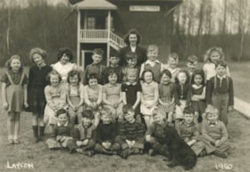
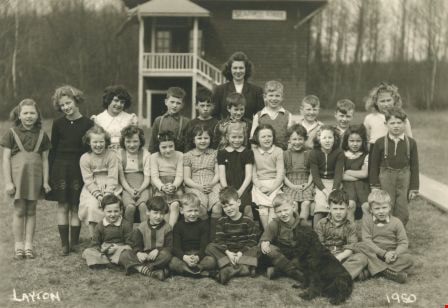
Seaforth School Class
https://search.heritageburnaby.ca/link/archivedescription37341
- Repository
- City of Burnaby Archives
- Date
- 1950
- Collection/Fonds
- Burnaby Historical Society fonds
- Description Level
- Item
- Physical Description
- 1 photograph : b&w ; 12.5 x 17.7 cm
- Scope and Content
- Photograph of twenty-seven students and their teacher seated and standing in rows in front of the school building. A black dog is sitting in the front, facing the rows of children. A label on the back of the photograph states that the students are from Seaforth School. Identified in the photograp…
- Repository
- City of Burnaby Archives
- Date
- 1950
- Collection/Fonds
- Burnaby Historical Society fonds
- Subseries
- Seaforth School subseries
- Physical Description
- 1 photograph : b&w ; 12.5 x 17.7 cm
- Description Level
- Item
- Record No.
- 355-005
- Access Restriction
- No restrictions
- Reproduction Restriction
- Reproduce for fair dealing purposes only
- Accession Number
- BHS1997-14
- Scope and Content
- Photograph of twenty-seven students and their teacher seated and standing in rows in front of the school building. A black dog is sitting in the front, facing the rows of children. A label on the back of the photograph states that the students are from Seaforth School. Identified in the photograph are: Mrs. Mary Johnson (nee MacDonald) teacher, in the far back. Back row (l to r): Sandra ?, Shirley Colden, Marcia Noel, Eldon Clarke, Billy Beaton, David Park, Graeme Smith, Calvert Broomfield, Leigh Tucker and Lillian Savage. Middle row (l to r): Sharon Milne, Gail Simpson, Thelma Mornes, Joan Dachiuk, Barbara Smith, Betty Hadfield, Judy Haddon, Wilma Heather, Merle Beaton and Sammy Savage. Front row (l to r): Dennis Dachiuk, Jerry Hadfield, Mike Lawrence, David MacPhail, Sydney Clarke, Joe Haddon and Jerry Green.
- Subjects
- Animals - Dogs
- Occupations - Teachers
- Names
- Seaforth School
- Johnson, Mary MacDonald
- Colden, Shirley
- Noel, Marcia
- Clarke, Eldon
- Beaton, Billy
- Park, David
- Smith, Graeme
- Broomfield, Calvert
- Tucker, Leigh
- Savage, Lillian
- Anderson, Gail
- Sampson, Gail
- Mornes, Thelma
- Dachiuk, Joan
- Smith, Barbara
- Hadfield, Betty
- Haddon, Judy
- Heather, Wilma
- Beaton, Merle
- Savage, Sammy
- Dachiuk, Dennis
- Hadfield, Jerry
- Lawrence, Mike
- MacPhail, David
- Clarke, Sydney
- Haddon, Joe
- Green, Jerry
- Media Type
- Photograph
- Notes
- Title based on label on verso of photograph
- Photographer identified as "Layton"
- Geographic Access
- Government Road
- Deer Lake Avenue
- Street Address
- 7881 Government Road
- 6501 Deer Lake Avenue
- Historic Neighbourhood
- Lozells (Historic Neighbourhood)
- Planning Study Area
- Government Road Area
Images

Standard Oil Company
https://search.heritageburnaby.ca/link/archivedescription34567
- Repository
- City of Burnaby Archives
- Date
- 1958
- Collection/Fonds
- Burnaby Historical Society fonds
- Description Level
- Item
- Physical Description
- 1 photograph : b&w ; 28.0 x 35.8 cm
- Scope and Content
- Aerial photograph of the Standard Oil Company Stanovan Refinery storage and shipping area, along the Burrard Inlet.
- Repository
- City of Burnaby Archives
- Date
- 1958
- Collection/Fonds
- Burnaby Historical Society fonds
- Subseries
- Photographs subseries
- Physical Description
- 1 photograph : b&w ; 28.0 x 35.8 cm
- Description Level
- Item
- Record No.
- 052-003
- Access Restriction
- No restrictions
- Reproduction Restriction
- Reproduce for fair dealing purposes only
- Accession Number
- BHS2007-04
- Scope and Content
- Aerial photograph of the Standard Oil Company Stanovan Refinery storage and shipping area, along the Burrard Inlet.
- Media Type
- Photograph
- Notes
- Title based on contents of photograph
- Geographic Access
- Eton Street
- Street Address
- 4403 Eton Street
- Historic Neighbourhood
- Vancouver Heights (Historic Neighbourhood)
- Planning Study Area
- Burnaby Heights Area
Images


Standard Oil Company
https://search.heritageburnaby.ca/link/archivedescription34568
- Repository
- City of Burnaby Archives
- Date
- 1958
- Collection/Fonds
- Burnaby Historical Society fonds
- Description Level
- Item
- Physical Description
- 1 photograph : b&w ; 27.8 x 35.5 cm
- Scope and Content
- Aerial photograph of the Standard Oil Company Stanovan Refinery, Burrard Inlet.
- Repository
- City of Burnaby Archives
- Date
- 1958
- Collection/Fonds
- Burnaby Historical Society fonds
- Subseries
- Photographs subseries
- Physical Description
- 1 photograph : b&w ; 27.8 x 35.5 cm
- Description Level
- Item
- Record No.
- 052-004
- Access Restriction
- No restrictions
- Reproduction Restriction
- Reproduce for fair dealing purposes only
- Accession Number
- BHS2007-04
- Scope and Content
- Aerial photograph of the Standard Oil Company Stanovan Refinery, Burrard Inlet.
- Media Type
- Photograph
- Photographer
- Aero Surveys Limited
- Notes
- Title based on contents of photograph
- Back of photo stamped: "Photo by Aero Surveys Limited, Vancouver, BC, Canada / Identification No.: BO-58-444"
- Geographic Access
- Eton Street
- Street Address
- 4403 Eton Street
- Historic Neighbourhood
- Vancouver Heights (Historic Neighbourhood)
- Planning Study Area
- Burnaby Heights Area
Images

![Trans Mountain Oil Pipe Line Co., [1958] thumbnail](/media/Hpo/_Data/_Archives_Images/_Unrestricted/001/097-001.jpg?width=280)
Trans Mountain Oil Pipe Line Co.
https://search.heritageburnaby.ca/link/archivedescription34688
- Repository
- City of Burnaby Archives
- Date
- [1958]
- Collection/Fonds
- Burnaby Historical Society fonds
- Description Level
- Item
- Physical Description
- 1 photograph : b&w ; 20.4 x 25.3 cm
- Scope and Content
- Aerial photograph of the Trans Mountain Oil Pipe Line Co. storage tanks on Burnaby Mountain.
- Repository
- City of Burnaby Archives
- Date
- [1958]
- Collection/Fonds
- Burnaby Historical Society fonds
- Subseries
- Photographs subseries
- Physical Description
- 1 photograph : b&w ; 20.4 x 25.3 cm
- Description Level
- Item
- Record No.
- 097-001
- Access Restriction
- No restrictions
- Reproduction Restriction
- Reproduce for fair dealing purposes only
- Accession Number
- BHS2007-04
- Scope and Content
- Aerial photograph of the Trans Mountain Oil Pipe Line Co. storage tanks on Burnaby Mountain.
- Media Type
- Photograph
- Photographer
- Commercial Illustrators Industrial Photographers
- Notes
- Title based on contents of photograph
- Stamp and annotation on back of photograph reads, "TA. 8817 / Commerical Illustrators / Industrial Photographers / 601 Denman St., Vancouver 5, B.C. / File No. 9412-13"
- Geographic Access
- Burnaby Mountain Conservation Area
- Shellmont Street
- Underhill Avenue
- Planning Study Area
- Lake City Area
Images
![Trans Mountain Oil Pipe Line Co., [1958] thumbnail](/media/Hpo/_Data/_Archives_Images/_Unrestricted/001/097-001.jpg)