Narrow Results By
Aerial photograph of Burnaby Mountain
https://search.heritageburnaby.ca/link/archivedescription64460
- Repository
- City of Burnaby Archives
- Date
- [1957 or 1958]
- Collection/Fonds
- Burnaby Historical Society fonds
- Description Level
- Item
- Physical Description
- 1 photograph : b&w ; 14 x 14 cm
- Scope and Content
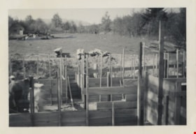
- Aerial photograph of the Burnaby Mountain park and Centennial Pavilion, under construction.
- Repository
- City of Burnaby Archives
- Date
- [1957 or 1958]
- Collection/Fonds
- Burnaby Historical Society fonds
- Subseries
- North Burnaby Board of Trade subseries
- Physical Description
- 1 photograph : b&w ; 14 x 14 cm
- Description Level
- Item
- Record No.
- 476-026
- Access Restriction
- No restrictions
- Reproduction Restriction
- Reproduce for fair dealing purposes only
- Accession Number
- BHS2005-8
- Scope and Content
- Aerial photograph of the Burnaby Mountain park and Centennial Pavilion, under construction.
- Subjects
- Aerial Photographs
- Land Clearing
- Media Type
- Photograph
- Photographer
- Hunting Survey Corporation Limited
- Notes
- Title based on contents of photograph
- Geographic Access
- Burnaby Mountain Conservation Area
- Centennial Way
- Street Address
- 100 Centennial Way
- Planning Study Area
- Burnaby Mountain Area
![Aerial photograph of Burnaby Mountain, [1957 or 1958] thumbnail](/media/hpo/_Data/_Archives_Images/_Unrestricted/371/476-025.jpg?width=280)
Aerial photograph of Burnaby Mountain
https://search.heritageburnaby.ca/link/archivedescription39742
- Repository
- City of Burnaby Archives
- Date
- [1957 or 1958]
- Collection/Fonds
- Burnaby Historical Society fonds
- Description Level
- Item
- Physical Description
- 1 photograph : b&w ; 14 x 14 cm
- Scope and Content
- Aerial photograph of the Burnaby Mountain park and Centennial Pavilion, under construction.
- Repository
- City of Burnaby Archives
- Date
- [1957 or 1958]
- Collection/Fonds
- Burnaby Historical Society fonds
- Subseries
- North Burnaby Board of Trade subseries
- Physical Description
- 1 photograph : b&w ; 14 x 14 cm
- Description Level
- Item
- Record No.
- 476-025
- Access Restriction
- No restrictions
- Reproduction Restriction
- Reproduce for fair dealing purposes only
- Accession Number
- BHS2005-8
- Scope and Content
- Aerial photograph of the Burnaby Mountain park and Centennial Pavilion, under construction.
- Subjects
- Aerial Photographs
- Land Clearing
- Media Type
- Photograph
- Photographer
- Hunting Survey Corporation Limited
- Notes
- Title based on contents of photograph.
- Geographic Access
- Burnaby Mountain Conservation Area
- Centennial Way
- Street Address
- 100 Centennial Way
- Planning Study Area
- Burnaby Mountain Area
Images
![Aerial photograph of Burnaby Mountain, [1957 or 1958] thumbnail](/media/hpo/_Data/_Archives_Images/_Unrestricted/371/476-025.jpg)

Birth of a House
https://search.heritageburnaby.ca/link/archivedescription79788
- Repository
- City of Burnaby Archives
- Date
- May 1950
- Collection/Fonds
- Yanko family fonds
- Description Level
- Item
- Physical Description
- 1 photograph : b&w ; 8 x 5.5 cm
- Scope and Content
- Photograph of the construction site for the Yanko family house at 7385 Broadway (later renumbered 7391) in Burnaby.
- Repository
- City of Burnaby Archives
- Date
- May 1950
- Collection/Fonds
- Yanko family fonds
- Physical Description
- 1 photograph : b&w ; 8 x 5.5 cm
- Material Details
- Secured to album page with photo corners
- Description Level
- Item
- Record No.
- 545-438
- Access Restriction
- No restrictions
- Reproduction Restriction
- No restrictions
- Accession Number
- 2012-09
- Scope and Content
- Photograph of the construction site for the Yanko family house at 7385 Broadway (later renumbered 7391) in Burnaby.
- Subjects
- Construction
- Land Clearing
- Media Type
- Photograph
- Notes
- Transcribed title (from album page)
- Note written on album page reads: "'Birth of a House' / Started May 1950 / Moved in April 6, 1951"
- Note in black ink on verso of photograph reads: "#6 House May 1950"
- Street Address
- 7391 Broadway
- Planning Study Area
- Sperling-Broadway Area
Images

![Clearing for shopping centre, [1958] thumbnail](/media/hpo/_Data/_Archives_Images/_Unrestricted/559/564-002.jpg?width=280)
Clearing for shopping centre
https://search.heritageburnaby.ca/link/archivedescription85130
- Repository
- City of Burnaby Archives
- Date
- [1958]
- Collection/Fonds
- Ben Bradley collection
- Description Level
- Item
- Physical Description
- 1 photograph : b&w ; 8.2 x 11.5 cm
- Scope and Content
- Photograph of land being cleared for the Brentwood Mall with Burnaby mountain in the background.
- Repository
- City of Burnaby Archives
- Date
- [1958]
- Collection/Fonds
- Ben Bradley collection
- Physical Description
- 1 photograph : b&w ; 8.2 x 11.5 cm
- Description Level
- Item
- Record No.
- 564-002
- Access Restriction
- No restrictions
- Reproduction Restriction
- Reproduce for fair dealing purposes only
- Accession Number
- 2013-30
- Scope and Content
- Photograph of land being cleared for the Brentwood Mall with Burnaby mountain in the background.
- Subjects
- Buildings - Commercial
- Land Clearing
- Media Type
- Photograph
- Notes
- Transcribed title
- Note on verso reads: "Clearing for shopping centre"
- Street Address
- 4567 Lougheed Highway
- Planning Study Area
- Brentwood Area
Images
![Clearing for shopping centre, [1958] thumbnail](/media/hpo/_Data/_Archives_Images/_Unrestricted/559/564-002.jpg)
![Clearing for shopping centre, [1958] thumbnail](/media/hpo/_Data/_Archives_Images/_Unrestricted/559/564-003.jpg?width=280)
Clearing for shopping centre
https://search.heritageburnaby.ca/link/archivedescription85131
- Repository
- City of Burnaby Archives
- Date
- [1958]
- Collection/Fonds
- Ben Bradley collection
- Description Level
- Item
- Physical Description
- 1 photograph : b&w ; 8.2 x 11.5 cm
- Scope and Content
- Photograph with tree stumps, rocks and dirt of land being cleared for the Brentwood Mall.
- Repository
- City of Burnaby Archives
- Date
- [1958]
- Collection/Fonds
- Ben Bradley collection
- Physical Description
- 1 photograph : b&w ; 8.2 x 11.5 cm
- Description Level
- Item
- Record No.
- 564-003
- Access Restriction
- No restrictions
- Reproduction Restriction
- Reproduce for fair dealing purposes only
- Accession Number
- 2013-30
- Scope and Content
- Photograph with tree stumps, rocks and dirt of land being cleared for the Brentwood Mall.
- Subjects
- Buildings - Commercial
- Land Clearing
- Media Type
- Photograph
- Notes
- Title based on contents of photograph
- Street Address
- 4567 Lougheed Highway
- Planning Study Area
- Brentwood Area
Images
![Clearing for shopping centre, [1958] thumbnail](/media/hpo/_Data/_Archives_Images/_Unrestricted/559/564-003.jpg)
![Clearing for shopping centre, [1958] thumbnail](/media/hpo/_Data/_Archives_Images/_Unrestricted/559/564-005.jpg?width=280)
Clearing for shopping centre
https://search.heritageburnaby.ca/link/archivedescription85133
- Repository
- City of Burnaby Archives
- Date
- [1958]
- Collection/Fonds
- Ben Bradley collection
- Description Level
- Item
- Physical Description
- 1 photograph : b&w ; 8.2 x 11.5 cm
- Scope and Content
- Photograph with tree stumps, rocks and dirt of land being cleared for the Brentwood Mall.
- Repository
- City of Burnaby Archives
- Date
- [1958]
- Collection/Fonds
- Ben Bradley collection
- Physical Description
- 1 photograph : b&w ; 8.2 x 11.5 cm
- Description Level
- Item
- Record No.
- 564-005
- Access Restriction
- No restrictions
- Reproduction Restriction
- Reproduce for fair dealing purposes only
- Accession Number
- 2013-30
- Scope and Content
- Photograph with tree stumps, rocks and dirt of land being cleared for the Brentwood Mall.
- Subjects
- Buildings - Commercial
- Land Clearing
- Media Type
- Photograph
- Notes
- Transcribed title
- Note on verso reads: "Clearing for shopping centre"
- Street Address
- 4567 Lougheed Highway
- Planning Study Area
- Brentwood Area
Images
![Clearing for shopping centre, [1958] thumbnail](/media/hpo/_Data/_Archives_Images/_Unrestricted/559/564-005.jpg)
![Clearing for the shopping centre, [1958] thumbnail](/media/hpo/_Data/_Archives_Images/_Unrestricted/559/564-001.jpg?width=280)
Clearing for the shopping centre
https://search.heritageburnaby.ca/link/archivedescription85125
- Repository
- City of Burnaby Archives
- Date
- [1958]
- Collection/Fonds
- Ben Bradley collection
- Description Level
- Item
- Physical Description
- 1 photograph : b&w ; 8.2 x 11.5 cm
- Scope and Content
- Photograph of children climbing on a large tree stump on land being cleared for the Brentwood Mall.
- Repository
- City of Burnaby Archives
- Date
- [1958]
- Collection/Fonds
- Ben Bradley collection
- Physical Description
- 1 photograph : b&w ; 8.2 x 11.5 cm
- Description Level
- Item
- Record No.
- 564-001
- Access Restriction
- No restrictions
- Reproduction Restriction
- Reproduce for fair dealing purposes only
- Accession Number
- 2013-30
- Scope and Content
- Photograph of children climbing on a large tree stump on land being cleared for the Brentwood Mall.
- Subjects
- Buildings - Commercial
- Land Clearing
- Media Type
- Photograph
- Notes
- Transcribed title
- Note on verso reads: "Clearing for shopping centre"
- Street Address
- 4567 Lougheed Highway
- Planning Study Area
- Brentwood Area
Images
![Clearing for the shopping centre, [1958] thumbnail](/media/hpo/_Data/_Archives_Images/_Unrestricted/559/564-001.jpg)
![Start of Brentwood Shopping Centre 1958, [1958] thumbnail](/media/hpo/_Data/_Archives_Images/_Unrestricted/559/564-004.jpg?width=280)
Start of Brentwood Shopping Centre 1958
https://search.heritageburnaby.ca/link/archivedescription85132
- Repository
- City of Burnaby Archives
- Date
- [1958]
- Collection/Fonds
- Ben Bradley collection
- Description Level
- Item
- Physical Description
- 1 photograph : b&w ; 8.2 x 11.5 cm
- Scope and Content
- Photograph with tree stumps, rocks and dirt of land being cleared for the Brentwood Mall.
- Repository
- City of Burnaby Archives
- Date
- [1958]
- Collection/Fonds
- Ben Bradley collection
- Physical Description
- 1 photograph : b&w ; 8.2 x 11.5 cm
- Description Level
- Item
- Record No.
- 564-004
- Access Restriction
- No restrictions
- Reproduction Restriction
- Reproduce for fair dealing purposes only
- Accession Number
- 2013-30
- Scope and Content
- Photograph with tree stumps, rocks and dirt of land being cleared for the Brentwood Mall.
- Subjects
- Buildings - Commercial
- Land Clearing
- Media Type
- Photograph
- Notes
- Transcribed title
- Note on verso reads: "Start of Brentwood Shopping Centre 1958"
- Street Address
- 4567 Lougheed Highway
- Planning Study Area
- Brentwood Area
Images
![Start of Brentwood Shopping Centre 1958, [1958] thumbnail](/media/hpo/_Data/_Archives_Images/_Unrestricted/559/564-004.jpg)
Walker family fonds
https://search.heritageburnaby.ca/link/archivedescription78708
- Repository
- City of Burnaby Archives
- Date
- 1948-1957 (date of originals); 2013
- Collection/Fonds
- Walker family fonds
- Description Level
- Fonds
- Physical Description
- 38 photographs (7 jpeg : col., 300 dpi ; 7 jpeg : col., 96 dpi ; 10 jpeg : b&w, 300 dpi ; 12 jpeg : b&w, 96 dpi). 1 drawing (jpeg) : col., 300 dpi ; 2 maps (jpeg) : col. ; 96 dpi ; 397.67 KB of textual records.
- Scope and Content
- Fonds consists of 41 jpegs of original photographs (some include annotation), maps, and newspaper clippings pertaining to Scotty Walker, his family and the Inter-City Driving Range that he created.
- Repository
- City of Burnaby Archives
- Date
- 1948-1957 (date of originals); 2013
- Collection/Fonds
- Walker family fonds
- Physical Description
- 38 photographs (7 jpeg : col., 300 dpi ; 7 jpeg : col., 96 dpi ; 10 jpeg : b&w, 300 dpi ; 12 jpeg : b&w, 96 dpi). 1 drawing (jpeg) : col., 300 dpi ; 2 maps (jpeg) : col. ; 96 dpi ; 397.67 KB of textual records.
- Description Level
- Fonds
- Access Restriction
- No restrictions
- Reproduction Restriction
- May be restricted by third party rights
- Accession Number
- 2013-15
- Scope and Content
- Fonds consists of 41 jpegs of original photographs (some include annotation), maps, and newspaper clippings pertaining to Scotty Walker, his family and the Inter-City Driving Range that he created.
- History
- Scotty Walker purchased the property at 974 12th Avenue in 1948 under the Veteran’s Land Act (VLA) grant from the government. He was in the Air Force during the Second World War. Previous to the purchase he ran a trucking business in New Westminster and lived at 1421 Nanaimo Street. The family consisted of Scotty, his wife Elizabeth, and three children, Alex, Barbara, and James. The land was overgrown with trees, scrub bushes, and a general swampy area. Scotty had the plan to build a Golf Driving Range, but it would take a lot of work. He owned three acres and leased three acres from the Lady of Mercy Church. Then they started working the land. The trees and scrub bush had to be removed and it was all done by hand. As the weather warmed and the swamp dried somewhat, Scotty got the idea to do selective burning. After many times doing this in small sections, the wind changed and the fire was headed for some houses on Tenth Avenue. The fire departments from New Westminster and Burnaby showed up and he was severely punished. It created other problems too. The land was swampy and when it dried, it was a peat bog, so the fire would burn down and turn up all over the place. That winter when the rains came, the land flooded and froze. The kids in the neighbourhood took advantage of the open spaces and brought out their skates. They had a great time. Some pigs were purchased with the idea that they could help dig up the roots and could be butchered later. Well they cleared the roots, but the kids all said they would not eat the pigs. The pigs were sold as they had become like pets. The land was then bulldozed into a berm on the 12th Street side of the land and a fence was built on top of the hill. The Walkers still had to clear the roots and branches that accumulated on the berm. The big problem was snakes. There were pits of water snakes that had been moved with the bulldozing. The family is not sure what happened with the snakes but eventually they moved. The area that would have been to the left of the property was still a swamp, so maybe they went there. The Walkers built drainage ditches through the land and let it drain to the natural slope toward Eighth Street. Construction on the Golf Range started and the grass was seeded. The “Inter-City Golf Range” opened on June 16, 1951. It had been a long hard road for the whole family but it worked out quite well. There was no automatic machine picking up balls, it was all done by hand and washed in a washing machine. Eventually they got Shag Bags that helped some but it was a huge job. The Golf Range ran for a few years and then Burnaby had a very sunny summer and the sun was in the patrons' eyes. So Scotty decided to move the buildings to the 12th Avenue part of the land. The club house and coffee shop was moved. The family took the building apart board by board and reconstructed it at the other end of the land. This worked well. All this had been accomplished on a shoestring budget as there was no big money behind anything. The Walkers cut the grass with gas hand mowers, washed the balls with the washing machine, and worked very long hours. Then the Catholic Church decided not to renew the lease. The family had worked so hard and now Scotty’s dream was dashed. It was a devastating time. Eventually the property was sold to the Christian Brothers and the buildings to Gus Brown in Richmond. The church bought the land for $25,000, in 1957. The end of the dream was very hard on everyone. Eventually life went on. It is sad that Scotty was just so far ahead of his time. He was a small man about 5’6" and about 140 pounds but had dreams as big as anyone and worked like three men to accomplish his dream. The cleared land was eventually developed into Saint Thomas Moore School. Biography provided by B. Kromm
- Media Type
- Photograph
- Creator
- Walker family
- Notes
- Title based on contents of fonds
- Photo catalogue 557
Kay North subseries
https://search.heritageburnaby.ca/link/archivedescription76
- Repository
- City of Burnaby Archives
- Date
- 1913-[1958]
- Collection/Fonds
- Burnaby Historical Society fonds
- Description Level
- Subseries
- Physical Description
- Textual records and photographs
- Scope and Content
- Subseries consists of photographs of Riverway Mission Sunday school classes and the Cropley/Rorison family, as well as a 1914 Deed of Land and 1913 Agreement of Sale of Land for the Cropley family.
- Repository
- City of Burnaby Archives
- Date
- 1913-[1958]
- Collection/Fonds
- Burnaby Historical Society fonds
- Subseries
- Kay North subseries
- Physical Description
- Textual records and photographs
- Description Level
- Subseries
- Accession Number
- BHS1991-04
- BHS1991-38
- Scope and Content
- Subseries consists of photographs of Riverway Mission Sunday school classes and the Cropley/Rorison family, as well as a 1914 Deed of Land and 1913 Agreement of Sale of Land for the Cropley family.
- History
- Kay Rorison North was one of the twin daughters of Burnaby carpenter William Rorison and Alma Cropley Rorison. Kay and her twin Evelyn were nine month old when her parents moved them and her two older brothers, Bill and Hugh, to Burnaby in 1922. Her younger brother, John, was not yet born. Kay's grandmother, Matilda Louise Cropley, bought three acres of land on Marine Drive (then called River Road) in South Burnaby and William built two houses on the property: one for his family and, six years later, one for his wife's widowed mother. They built a barn and kept cows, goats and the occasional pig. Her father built wooden toys and board games for the children. Kay went to Riverway West School with thirty-one other children, with grades one to four taught together in the one-room school house. She also attended Sunday school at Riverway mission for eight years and taught it there for another fifteen. Kay and her husband Doug have two daughters.
- Media Type
- Textual Record
- Photograph
- Creator
- North, Kay Rorison
- Notes
- Title based on contents and creator of subseries
- PC269, MSS051
James Massey family fonds
https://search.heritageburnaby.ca/link/archivedescription88394
- Repository
- City of Burnaby Archives
- Date
- 1933-1953 (date of originals), copied 2014
- Collection/Fonds
- James Massey family fonds
- Description Level
- Fonds
- Physical Description
- 18 photographs (tiffs) ; 600 dpi
- Scope and Content
- Records consist of 14 digitized photographs of Robert Burnaby Park and the Massey family with views of buildings, gardens, and trails.
- Repository
- City of Burnaby Archives
- Date
- 1933-1953 (date of originals), copied 2014
- Collection/Fonds
- James Massey family fonds
- Physical Description
- 18 photographs (tiffs) ; 600 dpi
- Material Details
- Tiffs are copies of original photographs
- Description Level
- Fonds
- Access Restriction
- No restrictions
- Reproduction Restriction
- May be restricted by third party rights
- Accession Number
- 2014-34
- Scope and Content
- Records consist of 14 digitized photographs of Robert Burnaby Park and the Massey family with views of buildings, gardens, and trails.
- History
- James Massey was born in Lancaster, England, in 1890 and immigrated to Burnaby in 1910. He married Alice Wilcock who also immigrated to Canada from Lancaster. James and Alice (Willcock) Massey were married in New Westminster on September 11, 1912. The couple built a house on three adjoining lots on the south side of 13th Avenue in Burnaby near Cumberland Road. James and Alice had three daughters, Betty, Grace, and Evelyn. James worked in road construction for the Burnaby Municipality, assisting to build Sperling Avenue (formerly named Pole Line Road) in 1912. He also worked in the brick yard in the glen behind the B.C. Penitentiary, which was owned by the Cogband family. In 1933, James accepted the job of caretaker for Robert Burnaby Park and moved his family onto the property. He was paid 30 dollars a week and the house was rent-free, leaving the family to rent out their house on 13th Avenue for extra revenue. The house that they moved into in Robert Burnaby Park was formerly owned by the Ramsey family and was a pre-fabricated design with no bathroom and a wood stove in the kitchen for heating. The park is situated south of Burnaby Lake on District Lots 87, 89, and 90. The land was originally owned by the Ramsey family, who purchased the property in 1905 and then sold it to Mr. Vidal in 1909. Annie Ramsey bought it back in 1917, but lost it to the city through tax sale proceedings where she entered into a lease agreement allowing her to live on the property until her death in 1926. As the caretaker of Robert Burnaby Park and Burnaby Lake, James also fulfilled the role of game warden. In his role as game warden, James would watch for any poachers, pull traps, take any firearms from children and also act as a deputy for the Provincial Police, which later became the R.C.M.P. The Massey family's dog, Pete, a spaniel cross, assisted Jim in tracking down any traps. Mr. Massey had three aviaries on the park property, where he raised canaries, and in 1939, he installed a goldfish pond. He was also responsible for constructing a playground and raising the flag up the flag pole on all public holidays. The family built a greenhouse behind their house to grow plants for the extensive park gardens. James' brother was the caretaker of Queens Park in New Westminster and assisted him in the planning and design of the gardens. During the 1930s, many unemployed script worked for Mr. Massey in clearing land and building trails and a bridge within the park. A garage was built at the foot of 2nd Street with two additional rooms built by Mr. Massey with the intention of them being used by the Parks Board. However, it was never used for this purpose and the Air Raid Patrol building from the 2nd Street School grounds was moved to the park and used for storage. The Army for the Common Good gardens were located on the west side of Hill Avenue with a shed for tools. The Army of the Common Good grew food and distributed it within the community to those in need during the Depression. The Massey family moved from the park in 1947 and James decided to run for the Burnaby School in the early 1950s. James retired at 65 years of age but continued to work as a custodian at the Armstrong Avenue School until the age of 72. James died in 1985 in Princeton, B.C., at the age of 95.
- Media Type
- Photograph
- Creator
- Massey family
- Notes
- Title based on contents of fonds
- Photo catalogue 581
Sheila Minni fonds
https://search.heritageburnaby.ca/link/archivedescription58376
- Repository
- City of Burnaby Archives
- Date
- [1955-1956]
- Collection/Fonds
- Sheila Minni fonds
- Description Level
- Fonds
- Physical Description
- 3 photographs : sepia ; 4.5 x 7 cm.
- Scope and Content
- Fonds consist of photographs showing St. Helen's Church in Burnaby Heights.
- Repository
- City of Burnaby Archives
- Date
- [1955-1956]
- Collection/Fonds
- Sheila Minni fonds
- Physical Description
- 3 photographs : sepia ; 4.5 x 7 cm.
- Description Level
- Fonds
- Access Restriction
- No restrictions
- Reproduction Restriction
- No known restrictions
- Accession Number
- 2009-04
- Scope and Content
- Fonds consist of photographs showing St. Helen's Church in Burnaby Heights.
- History
- In the first years of the 20th century, the hill overlooking the city of Vancouver was barely developed. This area, known as Vancouver Heights, commands a magnificent view of the city, the north shore mountains, and the sea. During the first decade, there was just a handful of people willing to brave the inconvenience of living in a remote area to dwell in such splendour. Among them were 10 Catholic families. They dreamt about establishing a Catholic community, a church, and perhaps even a school of their own. They knew it would take hard work and sacrifice to realize their dream. In 1912, the Second Narrows Bridge and several industrial plants were built in this area. Archbishop Neil McNeil, recognizing the potential for greater development, requested aid from Toronto's Catholic Extension Society, to help purchase property at the corner of Pandora and Ingleton to build a small church and home for the priest. The $6000 construction expense was donated by Mr. Justice Kelly, who requested that the church be named Saint Helen in memory of his daughter, Helen. On August 11, 1912, Saint Helen's church was blessed. 12 years later, in 1923, a second dream was realized with the construction of Saint Helen's School. The Sisters of Charity of Saint Vincent de Paul would staff the school for over 50 years, dedicating their lives to the education of thousands of children. 1936 began an era of unprecedented growth under the leadership of Msgr. Daniel Carey. In 1948, despite post-war hardships, he was able to inspire his community to build a new school. He then turned his attention to the over-crowded church and, in 1956, to the delight of the parishioners, the new Saint Helen's Church was blessed. By 1973, the demographics of Saint Helen's Parish had experienced a dramatic change. From the Anglo-Irish parishioners of the early years, Saint Helen's was experiencing a huge increase in parishioners of Italian descent. Archbishop James Carney, realizing the need to better serve these immigrants, asked the Scalabrinian Congregation to take the parish under its care. The second era of physical growth and development in the parish would come under the direction of these missionary priests. The 1970s, with Father Joseph Ponti as pastor, would see the construction of a new rectory, a state-of-the-art hall/gymnasium, and a fully renovated school. Father Joe's dream was the construction of a church, with this in mind, he began to purchase the necessary land. Succeeding pastors Father Angelo Calandra and Father Peter Sordi continued to work towards this dream, accumulating land and initiating the process. Father Claudio Holzer, upon assuming the responsibilities of pastor, took a firm hold of the dreams of his predecessors and shaped them into the reality of the new Saint Helen's Church. From the beginning, St. Helen's Parish has been an active community participant in this area of Burnaby and continues to enjoy this participation not only here but in Metro Vancouver as well. On August 11, 2012, St. Helen's Catholic Church and Parish celebrated its 100th anniversary. -Information contributed by M. Tesan has been combined with information from the official website of the church.
- Media Type
- Photograph
- Creator
- Minni, Sheila
- Notes
- Title based on contents of fonds.
- Photo catalogue 495
Small family fonds
https://search.heritageburnaby.ca/link/archivedescription91819
- Repository
- City of Burnaby Archives
- Date
- 1922-2016
- Collection/Fonds
- Small family fonds
- Description Level
- Fonds
- Physical Description
- 75 photographs : b&w & col. + 1 plan
- Scope and Content
- Fonds consists of photographs documenting the transformation of the Burnaby Lake area of Burnaby, B.C. from semi-rural in the 1920s to urbanized in 2016. Photographs depict the land and houses located on the corner of Douglas Road and Dominion Street as the property was rezoned and its density quad…
- Repository
- City of Burnaby Archives
- Date
- 1922-2016
- Collection/Fonds
- Small family fonds
- Physical Description
- 75 photographs : b&w & col. + 1 plan
- Description Level
- Fonds
- Access Restriction
- Open access
- Reproduction Restriction
- May be restricted by third party rights
- Accession Number
- 2017-01
- Scope and Content
- Fonds consists of photographs documenting the transformation of the Burnaby Lake area of Burnaby, B.C. from semi-rural in the 1920s to urbanized in 2016. Photographs depict the land and houses located on the corner of Douglas Road and Dominion Street as the property was rezoned and its density quadrupled. Fonds also includes photographs of the Small family house being moved to 5496 Dominion Street and the original landscape plan for 5118 Douglas Road.
- History
- In 1915, John W. Roberts and his wife Mary Allen Roberts moved from the United States to Canada along with their daughter, Lauretta. On first moving to Canada, the family lived in a rented house in Vancouver and John worked as a movie projectionist in the city. The couple had three more children, all sons: John A., Edward, and Roland. Circa 1921, John purchased a large parcel of land at the corner of Douglas Road and Dominion Street in Burnaby. This parcel encompassed the equivalent of at least six 66-foot lots along the south side of Dominion Street and the same along the north side of Norfolk Street. On their property, a barn and small living quarters were built. The family moved in, raising goats and growing potatoes to supplement their income. They also planted cherry, apple, and pear trees; hazelnut and walnut trees; raspberries; and a large vegetable garden, the fruits of which Mary preserved for year-round use. At this time, agricultural activities were common for families in the area: the Roberts' neighbours kept chickens for personal use and for selling eggs; grew mushrooms for commercial sale; and sold manure from an old buckboard drawn by Clydesdale horses. John built a new house in the middle of the Roberts’ lots on the southwest corner of Douglas Road and Dominion Street. The house faced Douglas Road and overlooked a large, well-landscaped front yard to the east and a full-sized, clay tennis court to the north. The family moved into this new house in 1925. When the Roberts ceased raising goats, the barn and original living quarters were reduced to a double-car garage with storage space plus a sawdust-insulated “root cellar”. John also built a house on the northwest corner of the lot at Douglas Road and Dominion Street (3093 Douglas Road), which was purchased by the Hardy family. In 1957, part of this property (3071 Douglas Road) was sold to the Brocklebanks who built a house and lived there. In addition, John built a house at the northwest corner of Douglas Road and Norfolk Street (5106 Douglas Road). The original purchaser of this house is unknown, but in 1949, it was bought by the Meyers family. In 1952 or 1953, the Meyers sold part of this property and the Manahans built a house on it, facing Douglas Road. Several other lots that John owned were also sold off over the years. By the 1950s, John owned only five 66-foot lots from Douglas Road west, along the south side Dominion Street. In 1954, John sold the lot furthest from Douglas Road (5486 Dominion Street) to a builder who built a “ranch-style” house and put it up for sale. John retired from his career as a movie projectionist in the 1950s. He, Mary, and Lauretta retained their US citizenship all their lives, although they never returned to the USA except for brief visits. John A., Edward, and Roland who, as children of US citizens, also had US citizenship, eventually moved to the US, where they remained for the rest of their lives. In 1945, Lauretta married Frederick Small. The couple lived in a rented house in Vancouver for a few years before moving in with John and Mary in Burnaby. The couple had four children: Elizabeth, Kathryn, Charles, and Martin. In 1955, Frederick purchased the rancher at 5486 Dominion Street and the family moved in. The Small children grew up enjoying the freedom of having their grandparent’s large property in addition to their parent’s yard to play in. The back lane that ran between Dominion Street and Norfolk Street was filled with trees and bushes, creating a narrow bit of “forest” to explore. In 1957, John died. Mary died in 1969, as did Frederick. Lauretta was executor for her mother’s and husband’s estates. After much consideration, she decided to sell the house at 5486 Dominion Street and move back into her childhood home. By doing so, she was able to settle her mother’s estate to the satisfaction of her brothers. Elizabeth married and moved away. Over the next few years, the “Roberts” house was home to Lauretta, Kathryn, Charles, and Martin, with the three grown children moving in and out several times during the 1970s. In 1981, Lauretta died. Her children discussed at length how to divide up the property, which consisted of four 66-foot lots, according to her will. None of her children wanted to see the old family house destroyed but the house straddled two lots. They finally decided that if one of them wanted to pay to move the house to sit on one of the lots, the “value” of the house would not enter into the settlement of the estate. Kathryn chose to do this. In 1982, the old house was moved to 5496 Dominion Street and Kathryn continued to live in it. Martin died in 1982. Elizabeth and Charles each inherited one lot and the last lot, which would have gone to Martin, was sold, the funds divided equally between Elizabeth, Kathryn, and Charles. The three lots between 5496 Dominion Street and Douglas Road were subdivided into 33-foot lots and six new houses were built. In 1993, the Meyers property and the Manahan property were subdivided into 33-foot lots facing Norfolk Street and the old houses were torn down and four new houses were built.
- Media Type
- Photograph
- Technical Drawing
- Creator
- Small family
Ben Bradley collection
https://search.heritageburnaby.ca/link/archivedescription85124
- Repository
- City of Burnaby Archives
- Date
- [1958]
- Collection/Fonds
- Ben Bradley collection
- Description Level
- Fonds
- Physical Description
- 5 photographs : b&w ; 11.5 x 8.2 cm
- Scope and Content
- Fonds comprises five photographs of the land being cleared for the future site of the Brentwood Mall shopping centre.
- Repository
- City of Burnaby Archives
- Date
- [1958]
- Collection/Fonds
- Ben Bradley collection
- Physical Description
- 5 photographs : b&w ; 11.5 x 8.2 cm
- Description Level
- Fonds
- Access Restriction
- No restrictions
- Reproduction Restriction
- May be restricted by third party rights
- Accession Number
- 2013-30
- Scope and Content
- Fonds comprises five photographs of the land being cleared for the future site of the Brentwood Mall shopping centre.
- History
- Ben Bradley is a former citizen of Burnaby and served on the Burnaby Heritage Commission between 1999-2000. Mr. Bradley has a keen interest in the history of suburbanization in Canada.
- Media Type
- Photograph
- Creator
- Bradley, Ben
- Notes
- Title based on contents of collection.
- Photo catalogue 564
Birth of a House
https://search.heritageburnaby.ca/link/archivedescription79793
- Repository
- City of Burnaby Archives
- Date
- May 1950
- Collection/Fonds
- Yanko family fonds
- Description Level
- Item
- Physical Description
- 1 photograph : b&w ; 5.5 x 8 cm
- Scope and Content
- Photograph of the construction of the Yanko family house at 7385 Broadway (later renumbered 7391) in Burnaby. Two unidentified men are visible at left, working to install wood beams, joists and support posts.
- Repository
- City of Burnaby Archives
- Date
- May 1950
- Collection/Fonds
- Yanko family fonds
- Physical Description
- 1 photograph : b&w ; 5.5 x 8 cm
- Material Details
- Secured to album page with photo corners
- Description Level
- Item
- Record No.
- 545-439
- Access Restriction
- No restrictions
- Reproduction Restriction
- No restrictions
- Accession Number
- 2012-09
- Scope and Content
- Photograph of the construction of the Yanko family house at 7385 Broadway (later renumbered 7391) in Burnaby. Two unidentified men are visible at left, working to install wood beams, joists and support posts.
- Media Type
- Photograph
- Notes
- Transcribed title (from album page)
- Note written on album page reads: "'Birth of a House' / Started May 1950 / Moved in April 6, 1951"
- Note in black ink on verso of photograph reads: "#1 House May 1950" and "up to that line; is all our land 84' x 86' / 26'6" 34' 23' [diagram] - House / I'll send you the plan"
- Street Address
- 7391 Broadway
- Planning Study Area
- Sperling-Broadway Area
Images

Doreen Lawson fonds
https://search.heritageburnaby.ca/link/archivedescription58356
- Repository
- City of Burnaby Archives
- Date
- 1950-2002
- Collection/Fonds
- Doreen Lawson fonds
- Description Level
- Fonds
- Physical Description
- 18 cm of textual records + approx. 1000 photographs
- Scope and Content
- Fonds consists of records created and received by Doreen Lawson during her career as Parks Commissioner (1965-1971), Burnaby City Council member (1972-1985, 1990-1999) and environmental advocate following her retirement from Council in 1999. Records include election campaign materials, congratulat…
- Repository
- City of Burnaby Archives
- Date
- 1950-2002
- Collection/Fonds
- Doreen Lawson fonds
- Physical Description
- 18 cm of textual records + approx. 1000 photographs
- Description Level
- Fonds
- Accession Number
- 2003-30
- 2015-15
- Scope and Content
- Fonds consists of records created and received by Doreen Lawson during her career as Parks Commissioner (1965-1971), Burnaby City Council member (1972-1985, 1990-1999) and environmental advocate following her retirement from Council in 1999. Records include election campaign materials, congratulatory letters and correspondence, community speeches and slideshow presentations regarding the conservation of Burnaby Lake, the administrative papers of the Burnaby Centennial Rhododendron and Spring Flower Show Society, and photographs of Burnaby waterways and wildlife.
- History
- Doreen Anne Fowler Lawson was born July 8, 1928, to Eva Barnhill and Leonard Fowler. Her parents met in Alberta but decided to move to Vancouver where they got married and Doreen was born. The family moved to the north side of Claude Avenue in Burnaby when Doreen was a few months old. In 1931, they moved to a house with an acre of land directly across the street from their first house.
- When Doreen was six, her family moved to Collingwood, Vancouver, near where her father grew up. This is where her brother Ron was born. The family moved again to County Line in Langley Prairie in 1944, which is where Doreen met Edward Lawson, her future husband. Soon after, they moved to a seven-acre plot in Burquitlam. Ed and Doreen Lawson’s eldest daughter, Linda, was born in 1954. Their second daughter, Wendy, was born in 1959 and their youngest, Lisa, was born in 1961. They lived in the Brentwood area, where all three daughters attended Brentwood Elementary School. Linda went on to Alpha Secondary School.
- In 1945, Doreen began her first of several office jobs, and in the early 1950s she became the first woman to be elected into a vice-president position within the BC Trade Union Congress (now the BC Federation of Labour).
- Doreen Lawson had a long and prolific political career, starting as Parks Commissioner in 1965, and serving as its chair from 1969 to 1971. She was instrumental in the selection and promotion of the rhododendron as the official flower of Burnaby in 1966. In 1971, she was elected to Burnaby City Council and, in 1972, Doreen proposed that Council take action to declare Burnaby Lake a wildlife sanctuary. After a 10-year campaign, she was able to convince Council to declare the park “a nature conservation area.” She put forward a policy of preservation for creeks and streams, as well as a proposal to preserve trees in subdivisions, both of which were adopted by Council. Doreen continued to serve on Council until 1985, during which time she initiated and chaired the Burnaby Information Committee, which designed the present Burnaby logo (and official flower pins) and established the Information Burnaby Newsletter. In 1979 Doreen Lawson won Vancouver Natural History Society’s Frank Sanford Award.
- In 1984, Doreen was elected the first woman president of the Federation of Canadian Municipalities. Doreen ran as a BC Liberal Party candidate in the new Federal Riding of Burnaby in 1979, and from 1985 to 1987, she served as the Executive Director of the British Columbia Liberal Party. As the B.C. Liberal Party Executive Director, her major responsibility was to work with both the Federal and Provincial Associations in implementing riding organizations and fundraising programs in preparation for election time. In the 1980s, Doreen was an active guest lecturer at Burnaby Elementary and High Schools as well as at the University of British Columbia and Simon Fraser University. Doreen was active in a variety of community clubs and organizations including: the Burnaby Library Board; Greater Vancouver Spinners and Weavers Guild; and Vancouver Natural History Society. She was an executive member of the Burnaby-New Westminster Canada Summer Games; the Burnaby Division of the United Way; Information Burnaby Committee; and the Brentwood Parent Teachers Association; as well as serving as the President of the Burnaby Voters Association from 1988-1990.
- In 1990, Doreen was elected back to Burnaby Council and put forward the rejuvenation of Burnaby Lake which she saw completed before her final year on Council in 1999. Doreen continued to be a strong environmental advocate for the protection and rejuvenation of Burnaby Lake after she retired from council.
- Doreen Lawson died October 11, 2003.
- Media Type
- Textual Record
- Photograph
- Creator
- Lawson, Doreen A.
- Notes
- Title based on contents of fonds
- MSS071, photo catalogue 605, photo catalogue 618
Ettinger family subseries
https://search.heritageburnaby.ca/link/archivedescription36
- Repository
- City of Burnaby Archives
- Date
- 1898-1971
- Collection/Fonds
- Burnaby Historical Society fonds
- Description Level
- Subseries
- Physical Description
- Textual records and photographs
- Scope and Content
- Subseries consists of photographs, newspaper clippings and legal documents related to the Ettinger family of Burnaby.
- Repository
- City of Burnaby Archives
- Date
- 1898-1971
- Collection/Fonds
- Burnaby Historical Society fonds
- Subseries
- Ettinger family subseries
- Physical Description
- Textual records and photographs
- Description Level
- Subseries
- Accession Number
- BHS2002-03
- Scope and Content
- Subseries consists of photographs, newspaper clippings and legal documents related to the Ettinger family of Burnaby.
- History
- James Gilmore Ettinger was born in Noel Road, Nova Scotia in 1863. He worked his way across Canada with the Canadian Pacific Railway (CPR) and landed in New Westminster in 1888. He was one of the first men who helped log the area for the settlement that is now Burnaby. With two other men, James started a brick manufacturing plant in the area of Deer Lake. In 1889, a second brick plant was started on Brickyard Road in Surrey on the bank of the Fraser River. Martha Harriet Hembrough was born in Leeds, England in 1874 and later moved to Haney. James Gilmore and Martha married in 1890 and had seven children: Evelina "Eve" (b. August 8, 1891, d. January 1, 1976); Ella May (b. ca. 1894, d. February 1983); Leonard; George William "Bill" (b. February 18, 1899, d. November 26, 1970); Stanley (b. December 27, 1901, d. March 10, 1966); Ethel (b. ca. 1904, d. December 22, 1982); and James. On May 19, 1911, the Ettingers bought parcel Lot 8, Block C sub-division 19 and 20 of DL 95 no. 556 for $350.00. Their eldest daughter, Evelina was signed over the Deed of Land for this property on April 21, 1914. In 1919, the Ettinger family was living at 1177 19th Avenue, Edmonds, Burnaby. James worked as a Road Foreman in Edmonds, and later as ward foreman for the Municipality. Ella May married Charles Morton Marshall on July 7, 1926. Evelina married Don Digby (d. October 21, 1965) on April 30, 1930. Ethel married George H. McKennell (d. June 18, 1985) on March 16, 1931. Bill worked as a Pacific Stage Lines (PSL) bus operator who “pulled” the first bus service between Vancouver and New Westminster and between Vancouver and Chilliwack in 1924. He received a number of National Safety Council non-accident awards during his career. He married Jane Wilson on July 11, 1931. James Gilmore died on June 9, 1948 at the age of 85. Martha died on February 9, 1955 at the age of 80.
- Media Type
- Textual Record
- Photograph
- Creator
- Ettinger, James Gilmore
- Notes
- Title based on contents of subseries
- PC 428, MSS147
Hill family and Vidal family fonds
https://search.heritageburnaby.ca/link/archivedescription82116
- Repository
- City of Burnaby Archives
- Date
- [1850-1983]
- Collection/Fonds
- Hill family and Vidal family fonds
- Description Level
- Fonds
- Physical Description
- 255 photographs : b&w and sepia and 9.5 cm of textual records : ill. (some col.)
- Scope and Content
- Fonds consists of photographs and textual records from the Vidal and Hill family. Textual records include handwritten family trees, typed and handwritten biographical information of the Jones, Wright, Hyde, Vidal, and Hill families, copies of photographic prints, published works by J. H. Vidal and …
- Repository
- City of Burnaby Archives
- Date
- [1850-1983]
- Collection/Fonds
- Hill family and Vidal family fonds
- Physical Description
- 255 photographs : b&w and sepia and 9.5 cm of textual records : ill. (some col.)
- Description Level
- Fonds
- Access Restriction
- No restrictions
- Accession Number
- 2013-03
- Scope and Content
- Fonds consists of photographs and textual records from the Vidal and Hill family. Textual records include handwritten family trees, typed and handwritten biographical information of the Jones, Wright, Hyde, Vidal, and Hill families, copies of photographic prints, published works by J. H. Vidal and William Cowper, newspaper clippings, and a New Testament.
- History
- Minard Gerald “Gerry” Hill was born in Burnaby on July 31, 1893, to Marian (nee Berkeley) and Bernard Richard Hill. Marian was born in London, England. Bernard Hill, born in Bengal, India, in 1858 to Sir Richard Hill and Jane Ann (nee Rollinson) where his father worked for the East Indian Railway, was one of the early inhabitants of Burnaby. Despite their years of training as engineers, Bernard, along with his brother, Louis Claude Hill, became strawberry farmers and owned all the land between Burnaby Lake and Deer Lake where Deer Creek runs, and halfway around Deer Lake. Bernard built his family home at Douglas Road near Deer Lake in 1892. After the decline in the strawberry industry, Bernard worked as a surveyor for the municipality. Bernard also served as a Burnaby trustee and as councilor of Burnaby in 1904, 1905, 1906, and 1909. Bernard and Marian had four children: A. Claude (born in England around 1885, married Marion “Mamie”), Frank L., Winnifred “Winnie” L., and Gerry. Gerry attended Miss Harriet Woodward’s kindergarten class, and went on to Edmonds School with Miss Ellen Lister as his teacher. He later went to Central High School in New Westminster, often on horseback. Gerry served in World War I, signing his recruitment papers on November 9, 1914. When he returned home, he worked felling trees, then as an apprentice surveyor and finally as a carpenter. His father, Bernard, died in Burnaby on March 27, 1939, at the age of 80. Bernard's brother, Louis, was one of the first members elected to the Burnaby council and served in 1892, 1893, 1894, and again from 1909-1910. Louis, born in 1860, married Annie Sarah Kendrick (born in 1896) and they moved to the Burnaby Lake area in the early 1890s. Together they had one child, Katherine “Kitty” Maude, born in 1898. The first Hill family home, “Brookfield,” was sold around 1907 and the family moved to their new home, “Broadview,” which was also built in the vicinity of Deer Lake. Kitty, their only child, married William “Bob” John Peers in 1925 and they went on to have three children: Robert C.K., Barbara (later Barbara Jeffrey), and Anne (later Anne Latham). Charlotte Elizabeth Vidal was born in 1897 in the United States to Louisa Sophia (nee Jones) and Herbert P. Vidal. Louisa Vidal (1871-1943) was a descendent of Jones of Exeter of England and the House of Llanio Cardigan of Wales. Herbert Vidal (1868-1934)’s father was Alexander Vidal (1819-1906). Alexander Vidal, born in Brocknell, England, immigrated to Upper Canada in 1835 and later served as a senator of Canada from 1873 to 1906. He married Catherine Louisa Wright, the daughter of Capt. William Elliot Wright. Both of Charlotte’s parents, Louisa and Herbert, were born in Ontario. Charlotte Vidal was sister to Dorothy Kate and Alexander E. E. Vidal. Gerry Hill (aged 27) and Charlotte E. Vidal (aged 23) married on September 28, 1920, in Vancouver. Gerry built a house for him and his wife about a thousand feet from his parents’ home. He also bought property at Yellow Point on Vancouver Island around this time. By the early 1930s, Gerry had moved to Yellow Point permanently and begun building the Yellow Point Lodge. Gerry and Charlotte bore three children: David, Lesley C. (born in 1929), and Gerald. Gerry was later remarried to Elizabeth (nee Holen) and had one child: Richard Grant McEwan Hill, born in Ladysmith. Lesley married M. Clarke and had two boys: Roy and Graham. She later married B. Durban and had four boys: Patrick, Michael, Gary, and Grant. Charlotte died on February 11, 1984, at the age of 87. Gerry died on January 30, 1988, in Ladysmith at the age of 93.
- Media Type
- Photograph
- Textual Record
- Creator
- Hill Family
- Vidal family
- Notes
- Title based on contents of fonds
- Photo catalogue 550, MSS176
Kathleen Moore family subseries
https://search.heritageburnaby.ca/link/archivedescription75
- Repository
- City of Burnaby Archives
- Date
- [1918]-1985
- Collection/Fonds
- Burnaby Historical Society fonds
- Description Level
- Subseries
- Physical Description
- 4 photographs and 1 pamphlet
- Scope and Content
- Subseries consists of a photograph of the Moxham residence on 6th Street in Burnaby, photograph of Edmonds Street School class, and a pamphlet called "Gilmore Generations". Also included are two photographs of the Brook House at 7725 4th Street.
- Repository
- City of Burnaby Archives
- Date
- [1918]-1985
- Collection/Fonds
- Burnaby Historical Society fonds
- Subseries
- Kathleen Moore family subseries
- Physical Description
- 4 photographs and 1 pamphlet
- Description Level
- Subseries
- Accession Number
- BHS1985-03
- BHS1985-09
- BHS1991-33
- Scope and Content
- Subseries consists of a photograph of the Moxham residence on 6th Street in Burnaby, photograph of Edmonds Street School class, and a pamphlet called "Gilmore Generations". Also included are two photographs of the Brook House at 7725 4th Street.
- History
- Kathleen Moxham was born in England in 1911. She emigrated from England with her family in 1912, settling first in New Westminster, BC. A year later, they moved to a large house on Sixth Street in Burnaby, BC. Kathleen’s father, Godfrey Moxham, worked as a contractor. He cleared land and built houses, including the Brook House (now the Normanna Rest Home). He died April 8, 1968. Kathleen attended Edmonds Elementary School and later Burnaby South High School. She remembers going on strike with fellow Edmonds Elementary students in 1919 when teachers refused to allow students a spring holiday after so much time had been lost to school closures brought on by the influenza epidemic earlier in the school year.
- Media Type
- Textual Record
- Photograph
- Creator
- Moore, Kathleen Agnes Moxham
- Notes
- Title based on creator of subseries
- PC 135, PC139, PC266, MSS156
Krewenchuk family fonds
https://search.heritageburnaby.ca/link/archivedescription88389
- Repository
- City of Burnaby Archives
- Date
- 1949-1993
- Collection/Fonds
- Krewenchuk family fonds
- Description Level
- Fonds
- Physical Description
- 5 cm. of textual records + 6 photographs : b&w + 10 photographs : col. + 2 architectural plans
- Scope and Content
- Records consist of personal and business records and photographs for Mike and Mary Krewenchuk and their son, Dennis Krewenchuk. Business records include photographs, guest books, property deeds, and land appraisals from when the Krewenchuks owned and operated the Nelson Hotel. Personal records inc…
- Repository
- City of Burnaby Archives
- Date
- 1949-1993
- Collection/Fonds
- Krewenchuk family fonds
- Physical Description
- 5 cm. of textual records + 6 photographs : b&w + 10 photographs : col. + 2 architectural plans
- Description Level
- Fonds
- Access Restriction
- No restrictions
- Reproduction Restriction
- Reproductions subject to FOIPPA
- Accession Number
- 2014-23
- 2015-05
- Scope and Content
- Records consist of personal and business records and photographs for Mike and Mary Krewenchuk and their son, Dennis Krewenchuk. Business records include photographs, guest books, property deeds, and land appraisals from when the Krewenchuks owned and operated the Nelson Hotel. Personal records include photographs, a last will and testament for Mike Krewenchuk, property records, appraisals and plans for 7460 Salisbury Avenue, and photographs and documents relating to their son, Dennis Krewenchuck's 1941 Packard convertible.
- History
- Michael (Mike) and Mary Krewenchuk lived in Burnaby and Vancouver, raising their five children, three boys and two girls. The family moved to Burnaby from Grand Forks in 1943 and purchased property on Grovenor Street on Capital Hill. Mike and Mary owned and operated a variety of small businesses in Burnaby and Vancouver, including: The Central Meat Market located at Sperling and Hastings Street; The Capital Hill General Store at 5530 Hastings Street in Burnaby from 1949; The Penny Market at 1806 Victoria Drive in Vancouver which they sold in 1953; The Payless Market at 5098 Joyce Street in Vancouver from 1954 to 1955; and the Nelson Motel (also known as The Nelson Bungalow Court and Nelson Auto Court) from 1956 to 1967. The couple sold the Nelson Motel in 1967, retiring and purchasing property at 7460 Salisbury Avenue where they built a new house. Mike Krewenchuk died in 1981 at the age of 79 years.
- Media Type
- Textual Record
- Photograph
- Creator
- Krewenchuk family
- Notes
- Title based on contents of fonds
- MSS191, MSS192, photo catalogue 582