Narrow Results By
Decade
- 2020s
- 2010s 196
- 2000s 336
- 1990s
- 1980s 390
- 1970s 652
- 1960s 487
- 1950s
- 1940s 368
- 1930s 396
- 1920s 692
- 1910s 355
- 1900s 92
- 1890s 42
- 1880s 5
- 1870s 4
- 1860s 5
- 1850s 2
- 1840s 1
- 1830s 1
- 1820s 1
- 1810s 1
- 1800s 2
- 1790s 1
- 1780s 1
- 1770s 1
- 1760s 1
- 1750s 1
- 1740s 1
- 1730s 1
- 1720s 1
- 1710s 1
- 1700s 1
- 1690s 1
- 1680s 1
- 1670s 1
- 1660s 1
- 1650s 1
- 1640s 1
- 1630s 1
- 1620s 1
- 1610s 1
- 1600s 1
Subject
- Advertising Medium - Signs and Signboards 5
- Aerial Photographs 3
- Agriculture 1
- Agriculture - Farms 2
- Arts - Drawings 1
- Buildings 1
- Buildings - Agricultural - Nurseries 1
- Buildings - Civic - City Halls 10
- Buildings - Commercial 5
- Buildings - Commercial - Grocery Stores 4
- Buildings - Commercial - Malls 3
- Buildings - Commercial - Restaurants 3
Creator
- Adair, Neal G. 3
- Armstrong, Sophie 1
- Associated Factory Mutual Fire Insurance Cos 1
- Bartel, Mario 12
- Bateman, Caroline Mary Wettenhall 1
- B.C. Tree Fruits Limited 1
- Bergson, George 8
- Bingham, Alfred "Alf" 2
- Blissett, Rebecca 3
- British Columbia Electric Company 1
- Brown, Cice Chandler 1
- Burnaby Village Museum 5
Person / Organization
- Adams, John 1
- Armitage, Jackie 1
- Barnet Rifle Club 1
- Bayntun, Charmaine "Sherrie" Yanko 5
- Bingham, Alfred "Alf" 3
- Bossort, Kathy 5
- Bradbury, Dr. Bettina 1
- Bridge Studios 7
- British Columbia Electric Railway Company 1
- British Columbia Hydro and Power Authority 1
- Burnaby City Hall 10
- Burnaby Fire Department 1
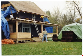
Porch roofing
https://search.heritageburnaby.ca/link/museumdescription11461
- Repository
- Burnaby Village Museum
- Date
- 1994
- Collection/Fonds
- Burnaby Village Museum fonds
- Description Level
- Item
- Physical Description
- 1 photograph : col. negative ; 35 mm
- Scope and Content
- Exterior view of the porch reconstruction with upper roofing being constructed.
- Repository
- Burnaby Village Museum
- Collection/Fonds
- Burnaby Village Museum fonds
- Series
- Jesse Love farmhouse series
- Description Level
- Item
- Physical Description
- 1 photograph : col. negative ; 35 mm
- Scope and Content
- Exterior view of the porch reconstruction with upper roofing being constructed.
- Subjects
- Buildings - Heritage
- Names
- Burnaby Village Museum
- Accession Code
- BV018.41.577
- Date
- 1994
- Media Type
- Photograph
- Scan Resolution
- 600
- Scan Date
- 08-Jul-19
- Scale
- 100
- Notes
- Title based on contents of photograph
- 1 col. photograph print accompanying negative
- Photograph is part of Section 2: "Porches" from Restoration Album BV018.41.81
Images

Ramsey family subseries
https://search.heritageburnaby.ca/link/archivedescription106
- Repository
- City of Burnaby Archives
- Date
- 1916 (date of original) -1999
- Collection/Fonds
- Burnaby Historical Society fonds
- Description Level
- Subseries
- Physical Description
- Textual record and graphic material
- Scope and Content
- Subseries consists of a photocopied certificate of birth for Eva Lilian Ramsey [Ramsay] as well as handwritten accounts of Ramsey family history and two family photographs.
- Repository
- City of Burnaby Archives
- Date
- 1916 (date of original) -1999
- Collection/Fonds
- Burnaby Historical Society fonds
- Subseries
- Ramsey family subseries
- Physical Description
- Textual record and graphic material
- Description Level
- Subseries
- Accession Number
- BHS1999-19
- Scope and Content
- Subseries consists of a photocopied certificate of birth for Eva Lilian Ramsey [Ramsay] as well as handwritten accounts of Ramsey family history and two family photographs.
- History
- Edwin Ramsey came to Canada from Scotland when he was about 11 years old. He was given farmland and quickly became an avid farmer. Edwin Ramsey married Annie Plummer circa 1893. This was Annie Plummer’s second marriage. In the early years of their marriage, Edwin and Annie lived in Orange Ridge, Manitoba and operated a store and post office. Their first child, Queenie, was born November 11, 1895. Albert Edwin "Bert" Ramsey was born January 27, 1898. Eva Lilian Ramsey was born January 24, 1900. Jessica “Jessie” Ramsey was born two years later. The Ramseys then headed to New Westminster. By 1905 they had bought "the Park” (what is now Robert Burnaby Park) from Mr. Wintermute for $4,000 cash. They moved into a large house already constructed on the property. The park was full of apple trees, a garden, pigs, two cows, horses and a buggy and wagon with a barn near the second street entrance. By now, the eldest, Queenie was enrolled at Burnaby’s first school. Twins Ernest “Ernie” and Dorothy “Doll” were born in 1906. Eva started at Edmonds School in 1908 when it was just built. Her siblings Queenie, Bert, Jeanie, Ernie and Doll all attended the school as well. In 1909 the Ramseys sold the park to Mr. Vidal of New Westminster and his syndicate along with a portable mill to Pemberton & Sons and received enough money to buy six lots on 12th Avenue where they built a large house. Gordon “Gord” Ramsey was born in that house in 1909. Soon after, they sold the house and moved to Blaine for six months, then on to Bellingham where they remained until Edwin and Annie divorced in 1914. Edwin moved alone to Alberta and Annie moved back to Burnaby with their children. Bert began attending the University of British Columbia where he studied to become a doctor. He joined the army in May of 1916, went to war and was killed at Vimy Ridge on April 12, 1917 at the age of 19. As Mr. Vital and his syndicate were to go to war as captains, Mr. Vital gave up the park property and Annie was able to take it back. Unfortunately, the new initiative of taxing wild lands caused Annie to lose the park property through tax sale proceedings. She then entered into a lease agreement with Burnaby which allowed her to stay on at "the Park." With twelve years of piano training, Annie was considered a talented musician and played the piano at St. Alban’s church for many years. Annie Ramsey died on October 3, 1926. Jessica, Dorothy and Queenie all moved to the United States. Gordon married a woman named Irene. Eva married William “Bill” Anderson at the St. Stephen’s Church in New Westminster on July 7, 1919. She and Bill were the first couple to marry there. They held their wedding reception at “the Park.” In 1921, Bill and Eva bought a home at 723 Second Street for $2450. They had one daughter, Dorothy "Dot" Anderson. Dot later married Robert V. “Bob” Douglas. Eva died in 1995.
- Media Type
- Textual Record
- Photograph
- Creator
- Ramsay, Eva Lillian
- Notes
- PC399 and MSS154
- Title based on contents of subseries
- Certificate reads "Ramsay" although the family continuously spelt their name "Ramsey"
Royal Bank exhibit series
https://search.heritageburnaby.ca/link/museumdescription17800
- Repository
- Burnaby Village Museum
- Date
- 1974-1999
- Collection/Fonds
- Burnaby Village Museum fonds
- Description Level
- Series
- Physical Description
- 127 photographs + 4 cm of textual records
- Scope and Content
- Series consists of records and photographs pertaining to the history, acquistion, restoration, opening and exhibit of the Royal Bank building that was relocated from it's original location at Britannia Beach to Heritage Village (Burnaby Village Museum) in 1976. Fonds is arranged into the following…
- Repository
- Burnaby Village Museum
- Collection/Fonds
- Burnaby Village Museum fonds
- Series
- Royal Bank exhibit series
- Description Level
- Series
- Physical Description
- 127 photographs + 4 cm of textual records
- Scope and Content
- Series consists of records and photographs pertaining to the history, acquistion, restoration, opening and exhibit of the Royal Bank building that was relocated from it's original location at Britannia Beach to Heritage Village (Burnaby Village Museum) in 1976. Fonds is arranged into the following subseries: 1) Royal Bank history and restoration records subseries 2) Royal Bank building photographs subseries 3) Royal Bank exhibit photographs subseries
- History
- The Royal Bank Main Branch Vancouver opened a sub branch operation at Britannia Beach in 1923. The bank provided twice monthly banking service at Britannia Beach and Town site (later named Mt. Sheer) until a permanent branch was established. The new branch building was completed and opened for business on December 1, 1950. The building was designed by bank manager, Mr. Fred Schwab in a simple and traditional design. Since there was no railway and Britannia was only accessible by boat, accommodations for the employees was incorporated into the design. This consisted of two rooms located at the rear of the branch building. The building was furnished with artifacts from the Royal Bank’s central warehouse and soon after with fixtures from the Royal Bank in Nelson including desks and a partition around the manager’s office which was cut down to fit. The bank had two old “Royal Bank of Canada” signs, one hung over the main entrance and the other located over the gable facing Howe Sound. A memorial plaque mounted on the wall inside the bank was one of 1,495 erected in memory of employees of the Royal Bank who died during World War I. The plaque was dedicated to Goldwin William Harron, who worked as a teller at the Royal Bank and was killed in action on July 5, 1916. Goldwin William Harron was born in Kitchener, Ontario in 1897 and later moved to Venn Saskatchewan and enlisted from the Venn Branch of the Royal Bank in October 1915. He first served with the 53rd Battalion and later joined the 28th Battalion. Fred Schwab served as bank manager between December 1, 1950 to August 1956 and Ken Moir served as bank manager from August 1956 until March 1958. When copper prices dropped in 1958, the Howe Sound Mining Co. closed down the mine and many miners and their families left the area. In 1964, Anaconda Mines purchased the Howe Sound Mining Co. and later reopened the mine. After 1958, the Britannia Beach branch continued to be operated as a sub-branch of the Sḵwx̱wú7mesh branch serving Britannia Beach and vicinity until 1974. In 1975, the Royal Bank building was donated to Heritage Village by Anaconda Britannia Mines. On April 24, 1976, the building was transported by barge up Howe Sound to North Vancouver and then up the Fraser River to New Westminster where it was then loaded onto a truck and transported to the Heritage Village site. The building and much of the labour was donated along with $15,000 from the Royal Bank of Canada. The bank safe, oak panelling and some of it’s original furnishings came with the building and were incorporated into the building and the Heritage Village Museum collection. A new building foundation and basement were constructed for the Royal Bank building before it was placed at the south end of Hill Street inside Heritage Village. The basement interior finishing, including wiring and plumbing was undertaken and completed by the Burnaby Centennial Lions Club as a service club charitable project. The Lions Club raised funds for the project and in turn were also granted the use of the completed basement space as a meeting room which they referred to as the “Lion’s Den”. The Royal Bank building and exhibit officially opened on the site of Heritage Village Museum May 23, 1977. The ribbon cutting was done by former bank managers Fred Schwab and Ken Moir. Speakers at the opening ceremony included; Royal Bank representative, M.D. Pollock, President of the Century Park Museum Association, Ted Burnham with closing remarks by Burnaby Mayor, Tom Constable. During the opening ceremony, a presentation of keys for the “Lions Den” was made by Burnaby Centennial Lion’s Club President, Erchil Nordby to Century Park Museum Association President, Ted Burnham and Controller of Anaconda Britannia Mines, Anaconda Canada Ltd. J. MacDonald delivered a speech regarding the donation of the bank building.
- Accession Code
- BV020.5
- BV022.1
- Date
- 1974-1999
- Media Type
- Photograph
- Textual Record
- Architectural Drawing
- Related Material
- Century Park Museum Associaton fonds
- Burnaby Village Museum fonds
- Arrangement
- The majority of the records were created and managed by Heritage Village Museum staff. Records follow the arrangement maintained by both Heritage Village Museum staff (1974-1989) and later, Burnaby Village Museum staff (1990-2020).
- Notes
- Title based on contents of series
- Further accruals are expected
- Some records within this collection are subject to FIPPA

Royal Crest Apartments
https://search.heritageburnaby.ca/link/archivedescription98680
- Repository
- City of Burnaby Archives
- Date
- 2022
- Collection/Fonds
- Disappearing Burnaby collection
- Description Level
- Item
- Physical Description
- 1 photograph (jpeg) : col.
- Scope and Content
- Photograph of the entrance and front path of Royal Crest Apartments, an apartment building located at 7165 Fulton Avenue. The building's exterior is stone and the path is bordered by an iron fence. The interior lobby is illuminated and visible through the glass door and windows, which feature the b…
- Repository
- City of Burnaby Archives
- Date
- 2022
- Collection/Fonds
- Disappearing Burnaby collection
- Physical Description
- 1 photograph (jpeg) : col.
- Description Level
- Item
- Record No.
- 634-027
- Access Restriction
- No restrictions
- Reproduction Restriction
- No restrictions
- Accession Number
- 2022-14
- Scope and Content
- Photograph of the entrance and front path of Royal Crest Apartments, an apartment building located at 7165 Fulton Avenue. The building's exterior is stone and the path is bordered by an iron fence. The interior lobby is illuminated and visible through the glass door and windows, which feature the building's name and a crest. The building was constructed in 1967.
- Media Type
- Photograph
- Photographer
- Cheung, Nakita
- Notes
- Title taken from the associated blog post
- Associated blog post: https://disappearingburnaby.wordpress.com/2022/06/30/royal-crest/
- Geographic Access
- Fulton Avenue
- Street Address
- 7165 Fulton Avenue
- Historic Neighbourhood
- Edmonds (Historic Neighbourhood)
- Planning Study Area
- Richmond Park Area
Images


Savoy Place
https://search.heritageburnaby.ca/link/archivedescription98668
- Repository
- City of Burnaby Archives
- Date
- 2022
- Collection/Fonds
- Disappearing Burnaby collection
- Description Level
- Item
- Physical Description
- 1 photograph (jpeg) : col.
- Scope and Content
- Photograph of the exterior of Savoy Place, an apartment complex located at 6355 Kingsway, at night. The building was constructed in 1968. Two people are standing in the illuminated lobby of the building, and wings of the building flank either side of the entrance, with trees and bushes lining the s…
- Repository
- City of Burnaby Archives
- Date
- 2022
- Collection/Fonds
- Disappearing Burnaby collection
- Physical Description
- 1 photograph (jpeg) : col.
- Description Level
- Item
- Record No.
- 634-015
- Access Restriction
- No restrictions
- Reproduction Restriction
- No restrictions
- Accession Number
- 2022-14
- Scope and Content
- Photograph of the exterior of Savoy Place, an apartment complex located at 6355 Kingsway, at night. The building was constructed in 1968. Two people are standing in the illuminated lobby of the building, and wings of the building flank either side of the entrance, with trees and bushes lining the sidewalk.
- Media Type
- Photograph
- Photographer
- Cheung, Nakita
- Notes
- Title taken from the associated blog post
- Associated blog post: https://disappearingburnaby.wordpress.com/2022/05/19/savoy-place/
- Geographic Access
- Kingsway
- Street Address
- 6355 Kingsway
- Historic Neighbourhood
- East Burnaby (Historic Neighbourhood)
- Planning Study Area
- Kingsway-Beresford Area
Images

Seaforth School fonds
https://search.heritageburnaby.ca/link/museumdescription18824
- Repository
- Burnaby Village Museum
- Date
- 1922-1972
- Collection/Fonds
- Seaforth School fonds
- Description Level
- Fonds
- Physical Description
- 1 survey plan + 4 cm of textual records
- Scope and Content
- Fonds consists of records from Seaforth School in Burnaby including a Register of Pupils (1922-1924); a Visitors' Book (1922-1972) and a survey plan from 1957.
- Repository
- Burnaby Village Museum
- Collection/Fonds
- Seaforth School fonds
- Description Level
- Fonds
- Physical Description
- 1 survey plan + 4 cm of textual records
- Scope and Content
- Fonds consists of records from Seaforth School in Burnaby including a Register of Pupils (1922-1924); a Visitors' Book (1922-1972) and a survey plan from 1957.
- History
- Seaforth school was built in 1922 in District Lot 42 on the corner of Piper and Goverment Streets in Burnaby. The school was named after its sponsor, the Seaforth Chapter of the Imperial Order of Daughters of the Empire. Bowman and Cullerne, the architects for the Burnaby School Board, designed the one room schoolhouse which was constructed by local contractor, Alphonse J. Toebaert. The school was moved to Burnaby Village Museum in 1983, and was opened to the public after extensive restoration in 1987.
- Creator
- Seaforth School
- Names
- Seaforth School
- Accession Code
- BV987.2
- Date
- 1922-1972
- Media Type
- Cartographic Material
- Textual Record
- Notes
- Title based on contents of fonds

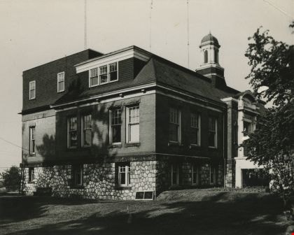
Second Municipal Hall at Kingsway and Edmonds
https://search.heritageburnaby.ca/link/archivedescription37286
- Repository
- City of Burnaby Archives
- Date
- 1958
- Collection/Fonds
- Burnaby Historical Society fonds
- Description Level
- Item
- Physical Description
- 1 photograph : b&w ; 10.1 x 12.7 cm
- Scope and Content
- Photograph of the old Municipal Hall building at Kingsway and Edmonds. This building was constructed in 1911 and used as the Municipal Hall until 1956, at which time the new Hall was built at the current location (4949 Canada Way).
- Repository
- City of Burnaby Archives
- Date
- 1958
- Collection/Fonds
- Burnaby Historical Society fonds
- Subseries
- Norah Code subseries
- Physical Description
- 1 photograph : b&w ; 10.1 x 12.7 cm
- Description Level
- Item
- Record No.
- 345-007
- Access Restriction
- No restrictions
- Reproduction Restriction
- Reproduce for fair dealing purposes only
- Accession Number
- BHS1997-05
- Scope and Content
- Photograph of the old Municipal Hall building at Kingsway and Edmonds. This building was constructed in 1911 and used as the Municipal Hall until 1956, at which time the new Hall was built at the current location (4949 Canada Way).
- Subjects
- Buildings - Civic - City Halls
- Names
- Burnaby City Hall
- Media Type
- Photograph
- Photographer
- Code, Norah
- Notes
- Title based on contents of photograph.
- Photographs in this collection were taken and compiled by Norah Code, former editor of the "Burnaby Courier" newspaper during the course of her work for the newspaper.
- Geographic Access
- Kingsway
- Street Address
- 7282 Kingsway
- Historic Neighbourhood
- Edmonds (Historic Neighbourhood)
- Planning Study Area
- Stride Avenue Area
Images

Silver Star Apartments
https://search.heritageburnaby.ca/link/archivedescription98679
- Repository
- City of Burnaby Archives
- Date
- 2022
- Collection/Fonds
- Disappearing Burnaby collection
- Description Level
- Item
- Physical Description
- 1 photograph (jpeg) : col.
- Scope and Content
- Photograph of the exterior and lawn of Silver Star Apartments, a low-rise apartment building located at 6425 Silver Avenue. The building was constructed in 1970. The photograph is taken from across a lawn and several trees and bushes are partially obscuring the building. A high-rise tower is visibl…
- Repository
- City of Burnaby Archives
- Date
- 2022
- Collection/Fonds
- Disappearing Burnaby collection
- Physical Description
- 1 photograph (jpeg) : col.
- Description Level
- Item
- Record No.
- 634-026
- Access Restriction
- No restrictions
- Reproduction Restriction
- No restrictions
- Accession Number
- 2022-14
- Scope and Content
- Photograph of the exterior and lawn of Silver Star Apartments, a low-rise apartment building located at 6425 Silver Avenue. The building was constructed in 1970. The photograph is taken from across a lawn and several trees and bushes are partially obscuring the building. A high-rise tower is visible behind the apartment building.
- Media Type
- Photograph
- Photographer
- Cheung, Nakita
- Notes
- Title taken from the associated blog post
- Associated blog post: https://disappearingburnaby.wordpress.com/2022/06/30/silver-star-apartments/
- Geographic Access
- Silver Avenue
- Street Address
- 6425 Silver Avenue
- Historic Neighbourhood
- Central Park (Historic Neighbourhood)
- Planning Study Area
- Maywood Area
Images


Star Light Apartments
https://search.heritageburnaby.ca/link/archivedescription98676
- Repository
- City of Burnaby Archives
- Date
- 2022
- Collection/Fonds
- Disappearing Burnaby collection
- Description Level
- Item
- Physical Description
- 1 photograph (jpeg) : col.
- Scope and Content
- Photograph of the entrance to Star Light Apartments, a low-rise apartment building located at 6555 Telford Avenue. The entrance is covered by a second-floor balcony and the lights are on inside; the plant-filled lobby and a large mirror visible through the front windows. The building was constructe…
- Repository
- City of Burnaby Archives
- Date
- 2022
- Collection/Fonds
- Disappearing Burnaby collection
- Physical Description
- 1 photograph (jpeg) : col.
- Description Level
- Item
- Record No.
- 634-023
- Access Restriction
- No restrictions
- Reproduction Restriction
- No restrictions
- Accession Number
- 2022-14
- Scope and Content
- Photograph of the entrance to Star Light Apartments, a low-rise apartment building located at 6555 Telford Avenue. The entrance is covered by a second-floor balcony and the lights are on inside; the plant-filled lobby and a large mirror visible through the front windows. The building was constructed in 1964.
- Media Type
- Photograph
- Photographer
- Cheung, Nakita
- Notes
- Title taken from the associated blog post
- Associated blog post: https://disappearingburnaby.wordpress.com/2022/06/24/star-light-apartments/
- Geographic Access
- Telford Avenue
- Street Address
- 6555 Telford Avenue
- Historic Neighbourhood
- Central Park (Historic Neighbourhood)
- Planning Study Area
- Maywood Area
Images


Star Light Apartments sign
https://search.heritageburnaby.ca/link/archivedescription98677
- Repository
- City of Burnaby Archives
- Date
- 2022
- Collection/Fonds
- Disappearing Burnaby collection
- Description Level
- Item
- Physical Description
- 1 photograph (jpeg) : col.
- Scope and Content
- Photograph of the Blue Sky Investments Ltd.'s sign on the lawn of Star Light Apartments, a low-rise apartment building located at 6555 Telford Avenue. The building was constructed in 1964. The photograph depicts the scene at dusk; the building's entrance is visible to the left, with its exterior li…
- Repository
- City of Burnaby Archives
- Date
- 2022
- Collection/Fonds
- Disappearing Burnaby collection
- Physical Description
- 1 photograph (jpeg) : col.
- Description Level
- Item
- Record No.
- 634-024
- Access Restriction
- No restrictions
- Reproduction Restriction
- No restrictions
- Accession Number
- 2022-14
- Scope and Content
- Photograph of the Blue Sky Investments Ltd.'s sign on the lawn of Star Light Apartments, a low-rise apartment building located at 6555 Telford Avenue. The building was constructed in 1964. The photograph depicts the scene at dusk; the building's entrance is visible to the left, with its exterior lights on, and Telford Avenue and other neighbouring towers are visible in the background.
- Subjects
- Buildings - Residential
- Buildings - Residential - Apartments
- Advertising Medium - Signs and Signboards
- Media Type
- Photograph
- Photographer
- Cheung, Nakita
- Notes
- Title taken from the associated blog post
- Associated blog post: https://disappearingburnaby.wordpress.com/2022/06/24/star-light-apartments/
- Geographic Access
- Telford Avenue
- Street Address
- 6555 Telford Avenue
- Historic Neighbourhood
- Central Park (Historic Neighbourhood)
- Planning Study Area
- Marlborough Area
Images

![St. Helen's Church Steeple, [1955-1956] thumbnail](/media/hpo/_Data/_Archives_Images/_Unrestricted/494/495-002.jpg?width=280)
St. Helen's Church Steeple
https://search.heritageburnaby.ca/link/archivedescription58378
- Repository
- City of Burnaby Archives
- Date
- [1955-1956]
- Collection/Fonds
- Sheila Minni fonds
- Description Level
- Item
- Physical Description
- 1 photograph : sepia ; 4.5 x 7 cm
- Scope and Content
- Photograph of the steeple of St. Helen's Church after it was torn down. The Church was replaced in 1956 when a new building was constructed. Siting inside the steeple are three children: the girl on the right has been identified as Sheila Minni, the boy seated up in the middle of the steeple is B…
- Repository
- City of Burnaby Archives
- Date
- [1955-1956]
- Collection/Fonds
- Sheila Minni fonds
- Physical Description
- 1 photograph : sepia ; 4.5 x 7 cm
- Description Level
- Item
- Record No.
- 495-002
- Access Restriction
- No restrictions
- Reproduction Restriction
- No known restrictions
- Accession Number
- 2009-04
- Scope and Content
- Photograph of the steeple of St. Helen's Church after it was torn down. The Church was replaced in 1956 when a new building was constructed. Siting inside the steeple are three children: the girl on the right has been identified as Sheila Minni, the boy seated up in the middle of the steeple is Bobby Priest and the other girl is known only as Katherine.
- Subjects
- Buildings - Religious - Churches
- Media Type
- Photograph
- Notes
- Title based on contents of photograph
- Geographic Access
- Triumph Street
- Street Address
- 3894 Triumph Street
- Historic Neighbourhood
- Vancouver Heights (Historic Neighbourhood)
- Planning Study Area
- Burnaby Heights Area
Images
![St. Helen's Church Steeple, [1955-1956] thumbnail](/media/hpo/_Data/_Archives_Images/_Unrestricted/494/495-002.jpg)

Sussex Ave Apartment
https://search.heritageburnaby.ca/link/archivedescription98657
- Repository
- City of Burnaby Archives
- Date
- 2022
- Collection/Fonds
- Disappearing Burnaby collection
- Description Level
- Item
- Physical Description
- 1 photograph (jpeg) : col.
- Scope and Content
- Photograph of the exterior of Sussex Ave Apartment, an apartment building located at 6749 Sussex Avenue. The building was constructed in 1958. The photograph depicts a fire escape between two storeys; the blinds are drawn on the apartments' windows, and one has a light shining within the apartment.
- Repository
- City of Burnaby Archives
- Date
- 2022
- Collection/Fonds
- Disappearing Burnaby collection
- Physical Description
- 1 photograph (jpeg) : col.
- Description Level
- Item
- Record No.
- 634-004
- Access Restriction
- No restrictions
- Reproduction Restriction
- No restrictions
- Accession Number
- 2022-14
- Scope and Content
- Photograph of the exterior of Sussex Ave Apartment, an apartment building located at 6749 Sussex Avenue. The building was constructed in 1958. The photograph depicts a fire escape between two storeys; the blinds are drawn on the apartments' windows, and one has a light shining within the apartment.
- Media Type
- Photograph
- Photographer
- Cheung, Nakita
- Notes
- Title taken from the associated blog post
- Associated blog post: https://disappearingburnaby.wordpress.com/2022/02/01/sussex-ave-apartment/
- Geographic Access
- Sussex Avenue
- Street Address
- 6749 Sussex Avenue
- Historic Neighbourhood
- Central Park (Historic Neighbourhood)
- Planning Study Area
- Maywood Area
Images


Sussex Court
https://search.heritageburnaby.ca/link/archivedescription98658
- Repository
- City of Burnaby Archives
- Date
- 2022
- Collection/Fonds
- Disappearing Burnaby collection
- Description Level
- Item
- Physical Description
- 1 photograph (jpeg) : col.
- Scope and Content
- Photograph of the exterior of Sussex Court, an apartment building located at 6780 Sussex Avenue. The photograph depicts the entire building from across the street at dusk. The building was constructed in 1954. Lights are shining through the central stairwell and a few of the apartments' windows.
- Repository
- City of Burnaby Archives
- Date
- 2022
- Collection/Fonds
- Disappearing Burnaby collection
- Physical Description
- 1 photograph (jpeg) : col.
- Description Level
- Item
- Record No.
- 634-005
- Access Restriction
- No restrictions
- Reproduction Restriction
- No restrictions
- Accession Number
- 2022-14
- Scope and Content
- Photograph of the exterior of Sussex Court, an apartment building located at 6780 Sussex Avenue. The photograph depicts the entire building from across the street at dusk. The building was constructed in 1954. Lights are shining through the central stairwell and a few of the apartments' windows.
- Media Type
- Photograph
- Photographer
- Cheung, Nakita
- Notes
- Title taken from the associated blog post
- Associated blog post: https://disappearingburnaby.wordpress.com/2022/02/02/sussex-court/
- Geographic Access
- Sussex Avenue
- Street Address
- 6780 Sussex Avenue
- Historic Neighbourhood
- Central Park (Historic Neighbourhood)
- Planning Study Area
- Maywood Area
Images


Sussex Villa
https://search.heritageburnaby.ca/link/archivedescription98659
- Repository
- City of Burnaby Archives
- Date
- 2022
- Collection/Fonds
- Disappearing Burnaby collection
- Description Level
- Item
- Physical Description
- 1 photograph (jpeg) : col.
- Scope and Content
- Photograph of part of the exterior and front lawn of Sussex Villa, an apartment complex located at 6620-6630 Sussex Avenue, at night. The building was constructed in 1965 and is set to be developed into a high-rise tower by Keltic Canada Development. A light is on inside one of the apartment window…
- Repository
- City of Burnaby Archives
- Date
- 2022
- Collection/Fonds
- Disappearing Burnaby collection
- Physical Description
- 1 photograph (jpeg) : col.
- Description Level
- Item
- Record No.
- 634-006
- Access Restriction
- No restrictions
- Reproduction Restriction
- No restrictions
- Accession Number
- 2022-14
- Scope and Content
- Photograph of part of the exterior and front lawn of Sussex Villa, an apartment complex located at 6620-6630 Sussex Avenue, at night. The building was constructed in 1965 and is set to be developed into a high-rise tower by Keltic Canada Development. A light is on inside one of the apartment windows and a sign for the "Metrotown - Regional Town Centre Notification of Area Plan" stands on the lawn.
- Subjects
- Buildings - Residential - Apartments
- Buildings - Residential
- Advertising Medium - Signs and Signboards
- Planning - City Planning
- Media Type
- Photograph
- Photographer
- Cheung, Nakita
- Notes
- Title taken from the associated blog post
- Associated blog post: https://disappearingburnaby.wordpress.com/2022/01/29/sussex-villa-2/
- Geographic Access
- Sussex Avenue
- Street Address
- 6620 Sussex Avenue
- 6630 Sussex Avenue
- Historic Neighbourhood
- Central Park (Historic Neighbourhood)
- Planning Study Area
- Maywood Area
Images


Sussex Villa with sign
https://search.heritageburnaby.ca/link/archivedescription98660
- Repository
- City of Burnaby Archives
- Date
- 2022
- Collection/Fonds
- Disappearing Burnaby collection
- Description Level
- Item
- Physical Description
- 1 photograph (jpeg) : col.
- Scope and Content
- Photograph of part of the exterior and front lawn of Sussex Villa, an apartment complex located at 6620-6630 Sussex Avenue, at night. The building was constructed in 1965 and is set to be developed into a high-rise tower by Keltic Canada Development. A sign standing on the lawn reads: "Land Loan" a…
- Repository
- City of Burnaby Archives
- Date
- 2022
- Collection/Fonds
- Disappearing Burnaby collection
- Physical Description
- 1 photograph (jpeg) : col.
- Description Level
- Item
- Record No.
- 634-007
- Access Restriction
- No restrictions
- Reproduction Restriction
- No restrictions
- Accession Number
- 2022-14
- Scope and Content
- Photograph of part of the exterior and front lawn of Sussex Villa, an apartment complex located at 6620-6630 Sussex Avenue, at night. The building was constructed in 1965 and is set to be developed into a high-rise tower by Keltic Canada Development. A sign standing on the lawn reads: "Land Loan" and "Domain Funding" with contact information, and a residential tower is visible in the background.
- Subjects
- Buildings - Residential - Apartments
- Buildings - Residential
- Advertising Medium - Signs and Signboards
- Media Type
- Photograph
- Photographer
- Cheung, Nakita
- Notes
- Title taken from the associated blog post
- Associated blog post: https://disappearingburnaby.wordpress.com/2022/01/29/sussex-villa-2/
- Geographic Access
- Sussex Avenue
- Street Address
- 6620 Sussex Avenue
- 6630 Sussex Avenue
- Historic Neighbourhood
- Central Park (Historic Neighbourhood)
- Planning Study Area
- Maywood Area
Images


Trafalgar Market
https://search.heritageburnaby.ca/link/archivedescription98665
- Repository
- City of Burnaby Archives
- Date
- 2022
- Collection/Fonds
- Disappearing Burnaby collection
- Description Level
- Item
- Physical Description
- 1 photograph (jpeg) : col.
- Scope and Content
- Photograph of the intersection of Imperial Street and Sussex Avenue at night and in the rain. The photograph shows the Trafalgar Market grocery store (located at 4398 Imperial Street; the building was constructed in 1940) on the corner, with a large display of flowers for sale under the awning in f…
- Repository
- City of Burnaby Archives
- Date
- 2022
- Collection/Fonds
- Disappearing Burnaby collection
- Physical Description
- 1 photograph (jpeg) : col.
- Description Level
- Item
- Record No.
- 634-012
- Access Restriction
- No restrictions
- Reproduction Restriction
- No restrictions
- Accession Number
- 2022-14
- Scope and Content
- Photograph of the intersection of Imperial Street and Sussex Avenue at night and in the rain. The photograph shows the Trafalgar Market grocery store (located at 4398 Imperial Street; the building was constructed in 1940) on the corner, with a large display of flowers for sale under the awning in front of the store. The street and traffic lights are reflected in the puddles on the road, and cars and other businesses are visible along Imperial Street.
- Subjects
- Buildings - Commercial
- Buildings - Commercial - Grocery Stores
- Buildings - Commercial - Stores
- Geographic Features - Roads
- Media Type
- Photograph
- Photographer
- Cheung, Nakita
- Notes
- Title taken from the associated blog post
- Associated blog post: https://disappearingburnaby.wordpress.com/2022/02/20/imperial-manor-2/
- Geographic Access
- Imperial Street
- Sussex Avenue
- Street Address
- 4398 Imperial Street
- Historic Neighbourhood
- Central Park (Historic Neighbourhood)
- Planning Study Area
- Sussex-Nelson Area
Images

W.L. Edmonds subseries
https://search.heritageburnaby.ca/link/archivedescription57802
- Repository
- City of Burnaby Archives
- Date
- February 1912 (date of original), copied [1985]
- Collection/Fonds
- Burnaby Historical Society fonds
- Description Level
- Subseries
- Physical Description
- 1 file of textual records
- Scope and Content
- Subseries consists documents pertaining to the W.L. Edmonds house on Broadman Avenue, designed and constructed by Disney and Tucker.
- Repository
- City of Burnaby Archives
- Date
- February 1912 (date of original), copied [1985]
- Collection/Fonds
- Burnaby Historical Society fonds
- Subseries
- W.L. Edmonds subseries
- Physical Description
- 1 file of textual records
- Description Level
- Subseries
- Accession Number
- BHS1985-16
- Scope and Content
- Subseries consists documents pertaining to the W.L. Edmonds house on Broadman Avenue, designed and constructed by Disney and Tucker.
- History
- W.L. Edmonds lived in Burnaby and was married to Beryl Briggs Edmonds.
- Media Type
- Textual Record
- Creator
- Edmonds, W.L.
- Notes
- MSS019
- Title based on contents of subseries
Yanko family fonds
https://search.heritageburnaby.ca/link/archivedescription74502
- Repository
- City of Burnaby Archives
- Date
- 1917-2010
- Collection/Fonds
- Yanko family fonds
- Description Level
- Fonds
- Physical Description
- 4 albums (1272 photographs : b&w and col.) and other material
- Scope and Content
- Fonds consists of four photographic albums, two scrapbooks, one guestbook, one recipe notebook, 19 loose photographs, and 1 cm of other textual records pertaining to the Yanko family. Included are photographs depicting the building of the Yanko family home at 7391 Broadway, Burnaby.
- Repository
- City of Burnaby Archives
- Date
- 1917-2010
- Collection/Fonds
- Yanko family fonds
- Physical Description
- 4 albums (1272 photographs : b&w and col.) and other material
- Description Level
- Fonds
- Access Restriction
- No restrictions
- Reproduction Restriction
- May be restricted by third party rights
- Accession Number
- 2012-09
- Scope and Content
- Fonds consists of four photographic albums, two scrapbooks, one guestbook, one recipe notebook, 19 loose photographs, and 1 cm of other textual records pertaining to the Yanko family. Included are photographs depicting the building of the Yanko family home at 7391 Broadway, Burnaby.
- History
- Annie D. Basiuk (later Yanko) was born on February 25, 1902, in Sheho, Saskatchewan (formerly Sheho, North West Territories). Daniel "Dan" Yanko was born in Kobyl'nya, Ukraine, in 1887, and immigrated to Canada in May or June of 1905. Dan married Annie D. Basiuk and they had 13 children together. Their son, John Ivan Yanko, was born on the family farm, near Kelliher, Saskatchewan, on June 27, 1923. In grade six, John was pulled out of school to help support the family. Eugenia “Jenny” Haresomovych (later Carman) was born August 8, 1904, in Galecia, Austria. She came to Canada in 1928, when her parents sent her to live with the Austrian consular in Halifax. A year later, she was in The Pas with Albert Edward Carman, with whom she would have three children. Their daughter, Leida Doria "Lillian Doris" Carman, was born in The Pas, Manitoba, on March 24, 1929. Jenny later re-married Joseph Nagy who was born in Hungary in October 3, 1900. Jenny, Joseph, and the children moved to Nelson, British Columbia, where Joseph worked for the Canadian Pacific Railway. At the age of 20, John Ivan Yanko met his future wife, Lillian Doris, while visiting relatives in Burnaby. Lillian received a rail pass because of her dad’s employment with the CPR and, at 14, had gone to visit her godmother in Burnaby. John and Lillian Doris were married on October 16, 1948, in Nelson, British Columbia, and moved into the basement of John’s sister’s house on Union Street. Lillian began working at the downtown Woodward’s store as a cashier in 1948. In 1950, the young couple bought property at 7385 (later renumbered 7391) Broadway in Burnaby and began constructing a house as they could afford it. Knowing she’d be let go if she was pregnant, when Lillian was expecting her first child, Jenny sewed her several versions of the same outfit; they all used the same material, but each was a little bit larger than the last to accommodate her expanding girth. Rhonda, born in 1953, and Charmaine, born in 1955, grew up in the Broadway home. They attended school at Sperling Elementary, and later at Burnaby North High School. Lillian left her job to be a stay-at-home mom when Rhonda was born, but that changed in 1963 when John and Charmaine were in a car accident that left John temporarily unable to work. Joseph Nagy died on April 20, 1962; his wife Jenny passed away on August 14, 1985. Dan died in 1976; his wife Annie died in 1997. John later returned to work, establishing his own tile-setting business and working until age 82. John and Lillian lived out the rest of their married lives on the Broadway property. John passed away in 2010; his wife Lillian Doris passed away in 2011.
- Media Type
- Textual Record
- Photograph
- Creator
- Yanko family
- Notes
- Title based on contents of fonds
- MSS170, photo catalogue 545