Narrow Results By

Bird's Eye View of the Burnaby Lake Area
https://search.heritageburnaby.ca/link/museumdescription15144
- Repository
- Burnaby Village Museum
- Date
- 1977
- Collection/Fonds
- Century Park Museum Association fonds
- Description Level
- Item
- Physical Description
- 1 map : b&w print on paper ; 43 x 63.5 cm
- Scope and Content
- Item consists of a map titled "Birds Eye View of the Burnaby Lake Area Circa 1910". The overview of the Burnaby Lake area was compiled and drawn at Heritage Village by curator John Adams and artist, Carol Swan. The map identifies the Burnaby Lake inter-urban tram line; roads including: Sperling Ave…
- Repository
- Burnaby Village Museum
- Collection/Fonds
- Century Park Museum Association fonds
- Description Level
- Item
- Physical Description
- 1 map : b&w print on paper ; 43 x 63.5 cm
- Material Details
- Scale indeterminable
- Scope and Content
- Item consists of a map titled "Birds Eye View of the Burnaby Lake Area Circa 1910". The overview of the Burnaby Lake area was compiled and drawn at Heritage Village by curator John Adams and artist, Carol Swan. The map identifies the Burnaby Lake inter-urban tram line; roads including: Sperling Avenue (Pole Line Road); Gilpin Avenue; Douglas Road; trail to Vancouver Westminster Road (Kingsway); Buckingham Avenue; Haszard Street; various farms and residences including: Charles Sprott "Norland"; H.T. Ceperley "Fairacres"; Claude Hill's "Brookfield farm" and "Broadview"; F.J. Hart's "Avalon"; Miss Woodward's former and new home, school and post office; Councillor Edgar's hunting cabin; Edgar Sprott's "Mayfield farm" and "Mayfield Lodge"; F.J. Peers "Greyfriars"; Arthur de Windt Haszard; Bernard Hill's boathouse as well as other landmarks including: Doran's Mill; tram stations; Burnaby Lake Store; logging camps; wood cutter's shacks; ice houses; cranberry bog; Still Creek; Deer Lake; Burnaby Lake; Deer Lake Creek; Provincial Government Reserve Proposed Hospital (later Oakalla Prison).
- Creator
- Adams, John
- Swan, Carol
- Names
- Hill, Arthur Claude
- Sprott, Charles Frederick
- Sprott, Louis "Edgar"
- Hart, Frederick John, 1884-1945
- Ceperley, H.T.
- Woodward, Maude
- Woodward, Harriet
- Peers, Francis J.
- Haszard, Arthur de Windt
- Hill, Bernard R.
- Geographic Access
- Deer Lake Avenue
- Sperling Avenue
- Haszard Street
- Buckingham Avenue
- Accession Code
- BV021.1.3
- Access Restriction
- No restrictions
- Reproduction Restriction
- No known restrictions
- Date
- 1977
- Media Type
- Cartographic Material
- Historic Neighbourhood
- Burnaby Lake (Historic Neighbourhood)
- Planning Study Area
- Burnaby Lake Area
- Related Material
- See also: Life with the Moores of Hart House : pioneer days on Burnaby's Deer Lake
- Scan Resolution
- 600
- Scan Date
- 2021-11-12
- Scale
- 100
- Notes
- Transcribed title
- Compiled by John Adams; illustration by Carol Swan
- The map depicts the Burnaby Lake Tram Line as being double tracked, whereas in reality it was single tracked.
- Map is part of the book "Life with the Moores of Hart House : pioneer days on Burnaby's Deer Lake https://search.heritageburnaby.ca/permalink/museumlibrary6314-102
Images


Bird's Eye View of the Burnaby Lake Area
https://search.heritageburnaby.ca/link/museumdescription17543
- Repository
- Burnaby Village Museum
- Date
- 1977
- Collection/Fonds
- Century Park Museum Association fonds
- Description Level
- Item
- Physical Description
- 1 map : b&w print with watercolour ; 43 x 63.5 cm
- Scope and Content
- Item consists of a map titled "Birds Eye View of the Burnaby Lake Area Circa 1910". The overview of the Burnaby Lake area was compiled and drawn at Heritage Village by curator John Adams and artist, Carol Swan. The map identifies the Burnaby Lake inter-urban tram line; roads including: Sperling Ave…
- Repository
- Burnaby Village Museum
- Collection/Fonds
- Century Park Museum Association fonds
- Description Level
- Item
- Physical Description
- 1 map : b&w print with watercolour ; 43 x 63.5 cm
- Material Details
- Scale indeterminable
- Scope and Content
- Item consists of a map titled "Birds Eye View of the Burnaby Lake Area Circa 1910". The overview of the Burnaby Lake area was compiled and drawn at Heritage Village by curator John Adams and artist, Carol Swan. The map identifies the Burnaby Lake inter-urban tram line; roads including: Sperling Avenue (Pole Line Road); Gilpin Avenue; Douglas Road; trail to Vancouver Westminster Road (Kingsway); Buckingham Avenue; Haszard Street; various farms and residences including: Charles Sprott "Norland"; H.T. Ceperley "Fairacres"; Claude Hill's "Brookfield farm" and "Broadview"; F.J. Hart's "Avalon"; Miss Woodward's former and new home, school and post office; Councillor Edgar's hunting cabin; Edgar Sprott's "Mayfield farm" and "Mayfield Lodge"; F.J. Peers "Greyfriars"; Arthur de Windt Haszard; Bernard Hill's boathouse as well as other landmarks including: Doran's Mill; tram stations; Burnaby Lake Store; logging camps; wood cutter's shacks; ice houses; cranberry bog; Still Creek; Deer Lake; Burnaby Lake; Deer Lake Creek; Provincial Government Reserve Proposed Hospital (later Oakalla Prison).
- Creator
- Adams, John
- Swan, Carol
- Names
- Hill, Arthur Claude
- Sprott, Charles Frederick
- Sprott, Louis "Edgar"
- Hart, Frederick John, 1884-1945
- Ceperley, H.T.
- Woodward, Maude
- Woodward, Harriet
- Peers, Francis J.
- Haszard, Arthur de Windt
- Hill, Bernard R.
- Geographic Access
- Deer Lake Avenue
- Sperling Avenue
- Haszard Street
- Buckingham Avenue
- Accession Code
- BV021.1.4
- Access Restriction
- No restrictions
- Reproduction Restriction
- No known restrictions
- Date
- 1977
- Media Type
- Cartographic Material
- Historic Neighbourhood
- Burnaby Lake (Historic Neighbourhood)
- Planning Study Area
- Burnaby Lake Area
- Related Material
- See also: Life with the Moores of Hart House : pioneer days on Burnaby's Deer Lake
- Scan Resolution
- 600
- Scan Date
- 2021-11-12
- Scale
- 100
- Notes
- Transcribed title
- Compiled by John Adams; illustration by Carol Swan
- The map depicts the Burnaby Lake Tram Line as being double tracked, whereas in reality it was single tracked.
- Map is part of the book "Life with the Moores of Hart House : pioneer days on Burnaby's Deer Lake https://search.heritageburnaby.ca/permalink/museumlibrary6314-102
- This is a print made from original illustration and appears to be hand-coloured with watercolour at a later date.
Images

Burnaby Centennial Committee "Heritage Park" Proposal
https://search.heritageburnaby.ca/link/museumdescription3867
- Repository
- Burnaby Village Museum
- Date
- [1971]
- Collection/Fonds
- Donald Copan collection
- Description Level
- File
- Physical Description
- 6 p. of textual records
- Scope and Content
- Proposal submitted by Hopping / Kovach / Grinnel Design Consultants Ltd. for the construction of Heritage Park.
- Repository
- Burnaby Village Museum
- Collection/Fonds
- Donald Copan collection
- Description Level
- File
- Physical Description
- 6 p. of textual records
- Scope and Content
- Proposal submitted by Hopping / Kovach / Grinnel Design Consultants Ltd. for the construction of Heritage Park.
- Names
- Burnaby Village Museum
- Accession Code
- BV005.54.784
- Access Restriction
- Restricted access
- Reproduction Restriction
- May be restricted by third party rights
- Date
- [1971]
- Media Type
- Textual Record
- Historic Neighbourhood
- Burnaby Lake (Historic Neighbourhood)
- Planning Study Area
- Morley-Buckingham Area
- Notes
- Title based on content of file
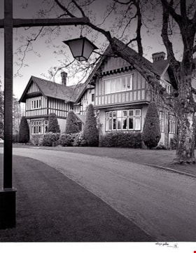
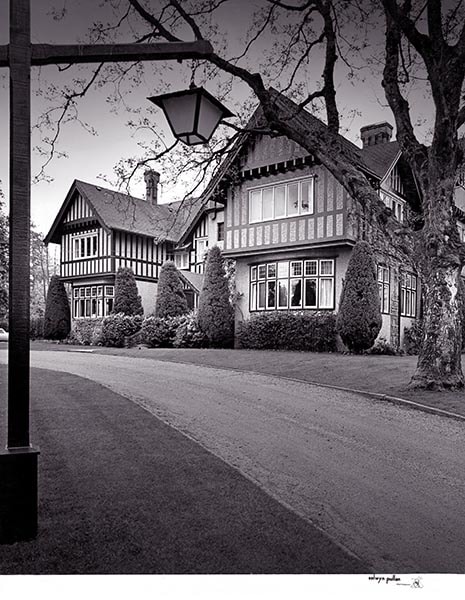
C. B. Riley Home - Western Homes & Living photographs
https://search.heritageburnaby.ca/link/archivedescription95583
- Repository
- City of Burnaby Archives
- Date
- March 1959
- Collection/Fonds
- City of Burnaby Archives photograph collection
- Description Level
- File
- Physical Description
- 2 photographs (tiff) and 3 p. of textual records (tiff, psd)
- Scope and Content
- File consists of a digitized copy of the article "Where Space is No Problem," from the March 1959 issue of Western Homes & Living Magazine, and related photographs. The article reports on the C. B. Riley home (formerly the F.J. Hart Estate "Avalon"; now Hart House) and includes floor plans and phot…
- Repository
- City of Burnaby Archives
- Date
- March 1959
- Collection/Fonds
- City of Burnaby Archives photograph collection
- Physical Description
- 2 photographs (tiff) and 3 p. of textual records (tiff, psd)
- Description Level
- File
- Record No.
- 625-001
- Access Restriction
- No restrictions
- Reproduction Restriction
- Reproduce for fair dealing purposes only
- Accession Number
- 2021-10
- Scope and Content
- File consists of a digitized copy of the article "Where Space is No Problem," from the March 1959 issue of Western Homes & Living Magazine, and related photographs. The article reports on the C. B. Riley home (formerly the F.J. Hart Estate "Avalon"; now Hart House) and includes floor plans and photographs of the house taken by Selwyn Pullan. Photographs in this file, which are also printed in the article, depict the kitchen and the exterior of the home.
- Subjects
- Buildings - Heritage
- Media Type
- Photograph
- Textual Record
- Photographer
- Pullan, Selwyn
- Notes
- Title based on content of file
- Street Address
- 6664 Deer Lake Avenue
- Historic Neighbourhood
- Burnaby Lake (Historic Neighbourhood)
- Planning Study Area
- Morley-Buckingham Area
Images
Century Park - Heritage Village Newsletter
https://search.heritageburnaby.ca/link/museumdescription3866
- Repository
- Burnaby Village Museum
- Date
- [1971]
- Collection/Fonds
- Donald Copan collection
- Description Level
- Item
- Physical Description
- 7 p. of textual records
- Scope and Content
- Newsletter by the Century Park Museum Association (CPMA). First page lists groups and individuals involved in Burnaby's Centennial '71 commemorative project including "The Burnaby Centennial '71 Committee"; "Burnaby Historical Society" president F. Wilson; "Burnaby Parks and Recreation Commission" …
- Repository
- Burnaby Village Museum
- Collection/Fonds
- Donald Copan collection
- Description Level
- Item
- Physical Description
- 7 p. of textual records
- Scope and Content
- Newsletter by the Century Park Museum Association (CPMA). First page lists groups and individuals involved in Burnaby's Centennial '71 commemorative project including "The Burnaby Centennial '71 Committee"; "Burnaby Historical Society" president F. Wilson; "Burnaby Parks and Recreation Commission" Chairman, Harry Pride and Adminstrator, Mr. B. Wilkinson; "Heritage Village" Director, Mr. R.G. Lott and Acting Curator Mrs. D. Norman and "Project Consultants". Following pages describe individual buildings in Heritage Village and CPMA's plans for the future of the village.
- Names
- Burnaby Village Museum
- Accession Code
- BV005.54.783
- Access Restriction
- No restrictions
- Reproduction Restriction
- No known restrictions
- Date
- [1971]
- Media Type
- Textual Record
- Historic Neighbourhood
- Burnaby Lake (Historic Neighbourhood)
- Planning Study Area
- Morley-Buckingham Area

The Epic of the Outhouse
https://search.heritageburnaby.ca/link/museumdescription10137
- Repository
- Burnaby Village Museum
- Date
- 1977
- Collection/Fonds
- William Harold Carr fonds
- Description Level
- File
- Physical Description
- 1 album (26 photographs) + 1 photograph : col. 9 x 13 cm mounted on paper 25.5 x 33 cm
- Scope and Content
- File consists of a thirty three page photograph album documenting the building of an outhouse by Century Park Museum Association volunteer, Harold Carr on the site of Heritage Village in Century Park (Burnaby Village Museum). The album is titled: "THE EPIC OF THE / OUTHOUSE / The Only (Privy) Biff…
- Repository
- Burnaby Village Museum
- Collection/Fonds
- William Harold Carr fonds
- Description Level
- File
- Physical Description
- 1 album (26 photographs) + 1 photograph : col. 9 x 13 cm mounted on paper 25.5 x 33 cm
- Material Details
- Pages include typewritten text pasted below each photograph
- Cover page and pages 30 to 32 are blank
- Scope and Content
- File consists of a thirty three page photograph album documenting the building of an outhouse by Century Park Museum Association volunteer, Harold Carr on the site of Heritage Village in Century Park (Burnaby Village Museum). The album is titled: "THE EPIC OF THE / OUTHOUSE / The Only (Privy) Biffy in Heritage Village with the Good Housekeeping / Seal of disApproval, 1977" / "Built by Mr. W. H. Carr / Privy Councillor / and Builder Emeritus". Photography by R. S. Banford & M. Smith, Marbo Photographics, North Vancouver."
- Creator
- Carr, William Harold
- Subjects
- Buildings - Other
- Accession Code
- BV011.59.1
- Access Restriction
- No restrictions
- Reproduction Restriction
- May be restricted by third party rights
- Date
- 1977
- Media Type
- Textual Record
- Photograph
- Historic Neighbourhood
- Burnaby Lake (Historic Neighbourhood)
- Planning Study Area
- Morley-Buckingham Area
- Arrangement
- Individual photographs are described at item level
- Scan Resolution
- 600
- Scan Date
- 2021-04-29
- Scale
- 100
- Photographer
- Marbo Photographics
- Notes
- Title based on contents of photograph album
- Continuation of the title reads : "The Only (Privy) Biffy in Heritage Village with the Good Housekeeping / Seal of disApproval, 1977" / "Built by Mr. W. H. Carr / Privy Councillor / and Builder Emeritus".
- Photographs from scrapbook have been described at item level (BV011.59.3 to BV011.5.3.31)
Images

Documents
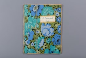
L.A. scrapbook 1964
https://search.heritageburnaby.ca/link/museumdescription4578
- Repository
- Burnaby Village Museum
- Date
- 1962-1971 (date of original), copied 2016
- Collection/Fonds
- Burnaby Girl Guides fonds
- Description Level
- File
- Physical Description
- 1 scrapbook (2 digital files (pdfs) + 55 photographs (tiffs)
- Scope and Content
- File consists of images of a scrapbook containing newspaper clippings, a few original documents about a pet show, a newsletter from 1971 and twelve photographs. The cover of the scrapbook is titled "L.A. Scrapbook 1964" and the inside front page reads: "Lakeview_District_Girl_Guide_Association".
- Repository
- Burnaby Village Museum
- Collection/Fonds
- Burnaby Girl Guides fonds
- Description Level
- File
- Physical Description
- 1 scrapbook (2 digital files (pdfs) + 55 photographs (tiffs)
- Scope and Content
- File consists of images of a scrapbook containing newspaper clippings, a few original documents about a pet show, a newsletter from 1971 and twelve photographs. The cover of the scrapbook is titled "L.A. Scrapbook 1964" and the inside front page reads: "Lakeview_District_Girl_Guide_Association".
- Accession Code
- BV016.49.82
- Access Restriction
- No restrictions
- Reproduction Restriction
- No known restrictions
- Date
- 1962-1971 (date of original), copied 2016
- Media Type
- Textual Record
- Photograph
- Historic Neighbourhood
- Burnaby Lake (Historic Neighbourhood)
- Planning Study Area
- Lakeview-Mayfield Area
- Notes
- Transcribed title
- Selective retention of original records from scrapbook
- Four photographs from scrapbook are described at item level (BV016.49.107 to BV016.49.110)
- Three photographs within scrapbook were created by Bea Walker (BV016.49.107 to BV016.49.109)
Images
