More like 'William Street and Gilmore Avenue'
Narrow Results By
Decade
- 2020s 148
- 2010s 125
- 2000s 683
- 1990s 735
- 1980s 535
- 1970s
- 1960s 402
- 1950s
- 1940s 664
- 1930s 652
- 1920s 705
- 1910s 661
- 1900s 280
- 1890s 43
- 1880s 71
- 1870s 5
- 1860s 3
- 1850s 1
- 1840s 1
- 1830s 1
- 1820s 1
- 1810s 1
- 1800s 1
- 1790s 1
- 1780s 1
- 1770s 1
- 1760s 1
- 1750s 1
- 1740s 1
- 1730s 1
- 1720s 1
- 1710s 1
- 1700s 1
- 1690s 1
- 1680s 1
- 1670s 1
- 1660s 1
- 1650s 1
- 1640s 1
- 1630s 1
- 1620s 1
- 1610s 1
- 1600s 1

Helen 'The Swinging Girl' Neon Sign
https://search.heritageburnaby.ca/link/landmark591
- Repository
- Burnaby Heritage Planning
- Description
- Commercial building.
- Associated Dates
- 1956
- Formal Recognition
- Heritage Designation, Community Heritage Register
- Other Names
- Helen's Childrens Wear Sign
- Street View URL
- Google Maps Street View
- Repository
- Burnaby Heritage Planning
- Other Names
- Helen's Childrens Wear Sign
- Geographic Access
- Hastings Street
- Associated Dates
- 1956
- Formal Recognition
- Heritage Designation, Community Heritage Register
- Enactment Type
- Bylaw No. 12771
- Enactment Date
- 19/04/2010
- Description
- Commercial building.
- Heritage Value
- While the building here is of some importance as the former North Burnaby municipal office, its primary importance is its delightful neon sign that has become a North Burnaby landmark. Helen Arnold opened Helen’s Childrens Wear shop in the building next door to the old Municipal offices in 1948. In 1955, when North Burnaby moved out, she moved into the vacated building. As part of the renovations, Helen enlisted the assistance of her good friend Jimmy Wallace, owner of Vancouver’s Wallace Neon Company, to create a new sign for her expanded business. One of the company’s designers, Reeve Lehman, created the swinging neon girl that was installed in 1956. Designed in two parts, one section of the sign is cloud shaped and reads ‘Helen’s’ while the other section is a moving representation of a little girl on a swing. The sign is nine feet six inches high and nine feet wide, and the lower section is animated with an internal motor and gears. It immediately became a landmark on Hastings Street, and recently the sign’s design fame has spread far and wide as one of the best surviving examples of kinetic neon art in North America.
- Locality
- Vancouver Heights
- Historic Neighbourhood
- Vancouver Heights (Historic Neighbourhood)
- Planning Study Area
- Willingdon Heights Area
- Community
- Burnaby
- Names
- Helen's Childrens Wear
- Street Address
- 4142 Hastings Street
- Street View URL
- Google Maps Street View
Images


Burris Street
https://search.heritageburnaby.ca/link/archivedescription36530
- Repository
- City of Burnaby Archives
- Date
- November 1978
- Collection/Fonds
- Burnaby Historical Society fonds
- Description Level
- Item
- Physical Description
- 1 photograph : col. ; 9 x 8.5 cm
- Scope and Content
- Photograph of Burris Street, including the "new" townhouse complex at One Arbour Lane when it was under construction.
- Repository
- City of Burnaby Archives
- Date
- November 1978
- Collection/Fonds
- Burnaby Historical Society fonds
- Subseries
- Lubbock family subseries
- Physical Description
- 1 photograph : col. ; 9 x 8.5 cm
- Description Level
- Item
- Record No.
- 289-019
- Access Restriction
- No restrictions
- Reproduction Restriction
- Reproduce for fair dealing purposes only
- Accession Number
- BHS1992-24
- Scope and Content
- Photograph of Burris Street, including the "new" townhouse complex at One Arbour Lane when it was under construction.
- Media Type
- Photograph
- Notes
- Title based on contents of photograph
- Geographic Access
- Burris Street
- Mayview Circle
- Historic Neighbourhood
- Burnaby Lake (Historic Neighbourhood)
- Planning Study Area
- Morley-Buckingham Area
Images

![From 1855 18th Avenue, [1972 or 1973] (date of original), copied 1991 thumbnail](/media/hpo/_Data/_Archives_Images/_Unrestricted/370/370-263.jpg?width=280)
From 1855 18th Avenue
https://search.heritageburnaby.ca/link/archivedescription37675
- Repository
- City of Burnaby Archives
- Date
- [1972 or 1973] (date of original), copied 1991
- Collection/Fonds
- Burnaby Historical Society fonds
- Description Level
- Item
- Physical Description
- 1 photograph : b&w ; 3.9 x 3.9 cm print on contact sheet 20.2 x 25.3 cm
- Scope and Content
- Photograph taken from the front of 1855 18th Avenue (later renumbered as the 7000 block of 18th Avenue), looking north down the street in the snow.
- Repository
- City of Burnaby Archives
- Date
- [1972 or 1973] (date of original), copied 1991
- Collection/Fonds
- Burnaby Historical Society fonds
- Subseries
- Burnaby Image Bank subseries
- Physical Description
- 1 photograph : b&w ; 3.9 x 3.9 cm print on contact sheet 20.2 x 25.3 cm
- Description Level
- Item
- Record No.
- 370-263
- Access Restriction
- No restrictions
- Reproduction Restriction
- No restrictions
- Accession Number
- BHS1999-03
- Scope and Content
- Photograph taken from the front of 1855 18th Avenue (later renumbered as the 7000 block of 18th Avenue), looking north down the street in the snow.
- Media Type
- Photograph
- Notes
- Title based on contents of photograph
- 1 b&w copy negative accompanying
- Negative has a pink cast
- Copied from col. photograph
- Geographic Access
- 18th Avenue
- Historic Neighbourhood
- Edmonds (Historic Neighbourhood)
- Planning Study Area
- Stride Avenue Area
Images
![From 1855 18th Avenue, [1972 or 1973] (date of original), copied 1991 thumbnail](/media/hpo/_Data/_Archives_Images/_Unrestricted/370/370-263.jpg)
![Residential streets, [196-] thumbnail](/media/hpo/_Data/_Archives_Images/_Unrestricted/316/366-028-10.jpg?width=280)
Residential streets
https://search.heritageburnaby.ca/link/archivedescription97613
- Repository
- City of Burnaby Archives
- Date
- [196-]
- Collection/Fonds
- Burnaby Historical Society fonds
- Description Level
- File
- Physical Description
- 22 photographs : b&w negatives
- Scope and Content
- Photographs of various residential streets and houses in North Burnaby. Streets and house numbers are not identified.
- Repository
- City of Burnaby Archives
- Date
- [196-]
- Collection/Fonds
- Burnaby Historical Society fonds
- Subseries
- Municipal record subseries
- Physical Description
- 22 photographs : b&w negatives
- Description Level
- File
- Record No.
- 366-028
- Access Restriction
- No restrictions
- Reproduction Restriction
- Reproduce for fair dealing purposes only
- Accession Number
- BHS1998-12
- Scope and Content
- Photographs of various residential streets and houses in North Burnaby. Streets and house numbers are not identified.
- Media Type
- Photograph
- Notes
- Title based on content of photographs
Images
![Residential streets, [196-] thumbnail](/media/hpo/_Data/_Archives_Images/_Unrestricted/316/366-028-10.jpg)

Venables Street
https://search.heritageburnaby.ca/link/archivedescription51598
- Repository
- City of Burnaby Archives
- Date
- 1970
- Collection/Fonds
- Harold H. Johnston fonds
- Description Level
- Item
- Physical Description
- 1 photograph (jpeg) : b&w
- Scope and Content
- Photograph taken looking west along Venables Street, taken from the home of Harold Johnston at 4447 Venables. Cars can be seen parked along the side of the street.
- Repository
- City of Burnaby Archives
- Date
- 1970
- Collection/Fonds
- Harold H. Johnston fonds
- Physical Description
- 1 photograph (jpeg) : b&w
- Description Level
- Item
- Record No.
- 483-074
- Access Restriction
- No restrictions
- Reproduction Restriction
- No reproduction permitted
- Accession Number
- 2008-08
- Scope and Content
- Photograph taken looking west along Venables Street, taken from the home of Harold Johnston at 4447 Venables. Cars can be seen parked along the side of the street.
- Media Type
- Photograph
- Photographer
- Johnston, Harold H.
- Notes
- Title based on contents of photograph
- Geographic Access
- Venables Street
- Street Address
- 4447 Venables Street
- Historic Neighbourhood
- Vancouver Heights (Historic Neighbourhood)
- Planning Study Area
- Willingdon Heights Area
Images


Venables Street
https://search.heritageburnaby.ca/link/archivedescription51613
- Repository
- City of Burnaby Archives
- Date
- 1970
- Collection/Fonds
- Harold H. Johnston fonds
- Description Level
- Item
- Physical Description
- 1 photograph (jpeg) : b&w
- Scope and Content
- Photograph taken looking east along Venables Street, taken from the home of Harold Johnston at 4447 Venables. Cars can be seen parked along the side of the street.
- Repository
- City of Burnaby Archives
- Date
- 1970
- Collection/Fonds
- Harold H. Johnston fonds
- Physical Description
- 1 photograph (jpeg) : b&w
- Description Level
- Item
- Record No.
- 483-075
- Access Restriction
- No restrictions
- Reproduction Restriction
- No reproduction permitted
- Accession Number
- 2008-08
- Scope and Content
- Photograph taken looking east along Venables Street, taken from the home of Harold Johnston at 4447 Venables. Cars can be seen parked along the side of the street.
- Media Type
- Photograph
- Photographer
- Johnston, Harold H.
- Notes
- Title based on contents of photograph
- Geographic Access
- Venables Street
- Street Address
- 4447 Venables Street
- Historic Neighbourhood
- Vancouver Heights (Historic Neighbourhood)
- Planning Study Area
- Willingdon Heights Area
Images


Venables Street panorama
https://search.heritageburnaby.ca/link/archivedescription51770
- Repository
- City of Burnaby Archives
- Date
- 1974
- Collection/Fonds
- Harold H. Johnston fonds
- Description Level
- Item
- Physical Description
- 1 photograph (jpeg) : b&w
- Scope and Content
- Photograph is a panorama of Venables Street taken from 4447 Venables - the home of photographer, Harold Johnston.
- Repository
- City of Burnaby Archives
- Date
- 1974
- Collection/Fonds
- Harold H. Johnston fonds
- Physical Description
- 1 photograph (jpeg) : b&w
- Description Level
- Item
- Record No.
- 483-086
- Access Restriction
- No restrictions
- Reproduction Restriction
- No reproduction permitted
- Accession Number
- 2008-08
- Scope and Content
- Photograph is a panorama of Venables Street taken from 4447 Venables - the home of photographer, Harold Johnston.
- Media Type
- Photograph
- Photographer
- Johnston, Harold H.
- Notes
- Title based on contents of photograph
- Geographic Access
- Venables Street
- Street Address
- 4447 Venables Street
- Historic Neighbourhood
- Vancouver Heights (Historic Neighbourhood)
- Planning Study Area
- Willingdon Heights Area
Images


Venables Street panorama
https://search.heritageburnaby.ca/link/archivedescription52573
- Repository
- City of Burnaby Archives
- Date
- 1975
- Collection/Fonds
- Harold H. Johnston fonds
- Description Level
- Item
- Physical Description
- 1 photograph (jpeg) : b&w
- Scope and Content
- Photograph is a panorama of Venables Street after a snowfall. The photograph was taken outside of the Johnston family home at 4447 Venables Street (which can be seen at centre).
- Repository
- City of Burnaby Archives
- Date
- 1975
- Collection/Fonds
- Harold H. Johnston fonds
- Physical Description
- 1 photograph (jpeg) : b&w
- Description Level
- Item
- Record No.
- 483-096
- Access Restriction
- No restrictions
- Reproduction Restriction
- No reproduction permitted
- Accession Number
- 2008-08
- Scope and Content
- Photograph is a panorama of Venables Street after a snowfall. The photograph was taken outside of the Johnston family home at 4447 Venables Street (which can be seen at centre).
- Media Type
- Photograph
- Photographer
- Johnston, Harold H.
- Notes
- Title based on contents of photograph
- Geographic Access
- Venables Street
- Street Address
- 4447 Venables Street
- Historic Neighbourhood
- Vancouver Heights (Historic Neighbourhood)
- Planning Study Area
- Willingdon Heights Area
Images

![Walking to June Ickringills house, [1957 or 1958] thumbnail](/media/hpo/_Data/_Archives_Images/_Unrestricted/205/246-011.jpg?width=280)
Walking to June Ickringills house
https://search.heritageburnaby.ca/link/archivedescription52971
- Repository
- City of Burnaby Archives
- Date
- [1957 or 1958]
- Collection/Fonds
- Burnaby Historical Society fonds
- Description Level
- Item
- Physical Description
- 1 photograph : b&w ; 7 x 10 cm, mounted on heavy-weight paper 17.5 x 27.5 cm
- Scope and Content
- Photograph of four kindergartners walking along a gravel sidewalk, along a gravel road to June Ickringills house. The girl in front is wearing a plaid dress, and the three boys behind her are wearing short pants and short-sleeve dress shirts. There is a woman in a white dress walking on the other s…
- Repository
- City of Burnaby Archives
- Date
- [1957 or 1958]
- Collection/Fonds
- Burnaby Historical Society fonds
- Subseries
- Tinkerbell Kindergarten subseries
- Physical Description
- 1 photograph : b&w ; 7 x 10 cm, mounted on heavy-weight paper 17.5 x 27.5 cm
- Description Level
- Item
- Record No.
- 246-011
- Access Restriction
- No restrictions
- Reproduction Restriction
- Reproduce for fair dealing purposes only
- Accession Number
- BHS1990-12
- Scope and Content
- Photograph of four kindergartners walking along a gravel sidewalk, along a gravel road to June Ickringills house. The girl in front is wearing a plaid dress, and the three boys behind her are wearing short pants and short-sleeve dress shirts. There is a woman in a white dress walking on the other side of the street, in front of a house with a white picket fence.
- Media Type
- Photograph
- Notes
- Title based on contents of photograph
- Handwritten note on paper mount reads: "Visit to June Ickringill's Home 1957-1958"
Images
![Walking to June Ickringills house, [1957 or 1958] thumbnail](/media/hpo/_Data/_Archives_Images/_Unrestricted/205/246-011.jpg)
![Overpass, [195-] (date of original), copied 1976 thumbnail](/media/hpo/_Data/_BVM_Images/1974/197602510029.jpg?width=280)
Overpass
https://search.heritageburnaby.ca/link/museumdescription1624
- Repository
- Burnaby Village Museum
- Date
- [195-] (date of original), copied 1976
- Collection/Fonds
- Burnaby Village Museum Photograph collection
- Description Level
- Item
- Physical Description
- 1 photograph : col. negative ; 4.5 x 6.5 cm
- Scope and Content
- Photograph of a newly constructed overpass, with a roadway below prepared for construction. An unidentified man is standing on the right side. The location is unidentified, but it is likely that the photograph was taken in Burnaby.
- Repository
- Burnaby Village Museum
- Collection/Fonds
- Burnaby Village Museum Photograph collection
- Description Level
- Item
- Physical Description
- 1 photograph : col. negative ; 4.5 x 6.5 cm
- Scope and Content
- Photograph of a newly constructed overpass, with a roadway below prepared for construction. An unidentified man is standing on the right side. The location is unidentified, but it is likely that the photograph was taken in Burnaby.
- Accession Code
- HV976.251.29
- Access Restriction
- No restrictions
- Reproduction Restriction
- May be restricted by third party rights
- Date
- [195-] (date of original), copied 1976
- Media Type
- Photograph
- Scan Resolution
- 300
- Scan Date
- 22/8/2006
- Scale
- 100
- Notes
- Title based on contents of photograph
- The print is made as a black and white print from a colour negative film
Images
![Overpass, [195-] (date of original), copied 1976 thumbnail](/media/hpo/_Data/_BVM_Images/1974/197602510029.jpg)
![Street clearing, [195-] (date of original), copied 1976 thumbnail](/media/hpo/_Data/_BVM_Images/1974/197602510027.jpg?width=280)
Street clearing
https://search.heritageburnaby.ca/link/museumdescription1622
- Repository
- Burnaby Village Museum
- Date
- [195-] (date of original), copied 1976
- Collection/Fonds
- Burnaby Village Museum Photograph collection
- Description Level
- Item
- Physical Description
- 1 photograph : col. negative ; 4.5 x 6.5 cm
- Scope and Content
- Photograph of the Grandview ramp off of the Trans Canada Highway in Burnaby that is cleared, possibly in preparation for the highway. The clearing for the street is several lanes wide, and in the distance, an overpass bridge can be seen. There are houses and along both sides of the cleared street.
- Repository
- Burnaby Village Museum
- Collection/Fonds
- Burnaby Village Museum Photograph collection
- Description Level
- Item
- Physical Description
- 1 photograph : col. negative ; 4.5 x 6.5 cm
- Scope and Content
- Photograph of the Grandview ramp off of the Trans Canada Highway in Burnaby that is cleared, possibly in preparation for the highway. The clearing for the street is several lanes wide, and in the distance, an overpass bridge can be seen. There are houses and along both sides of the cleared street.
- Accession Code
- HV976.251.27
- Access Restriction
- No restrictions
- Reproduction Restriction
- May be restricted by third party rights
- Date
- [195-] (date of original), copied 1976
- Media Type
- Photograph
- Scan Resolution
- 300
- Scan Date
- 22/8/2006
- Scale
- 100
- Notes
- Title based on contents of photograph
- The print is made as a black and white print from a colour negative film
Images
![Street clearing, [195-] (date of original), copied 1976 thumbnail](/media/hpo/_Data/_BVM_Images/1974/197602510027.jpg)

Widening of Scott Road
https://search.heritageburnaby.ca/link/archivedescription56677
- Repository
- City of Burnaby Archives
- Date
- March 1976, published March 24, 1976
- Collection/Fonds
- Columbian Newspaper collection
- Description Level
- Item
- Physical Description
- 1 photograph : b&w ; 7.5 x 14 cm
- Scope and Content
- Photograph of the process of widening Scott Road in Surrey BC. The process was undertaken by the provincial government. Citizens were upset as this process included cutting down century-old trees (stumps of these former trees are visible in this photograph).
- Repository
- City of Burnaby Archives
- Date
- March 1976, published March 24, 1976
- Collection/Fonds
- Columbian Newspaper collection
- Physical Description
- 1 photograph : b&w ; 7.5 x 14 cm
- Description Level
- Item
- Record No.
- 480-531
- Access Restriction
- No restrictions
- Reproduction Restriction
- No restrictions
- Accession Number
- 2003-02
- Scope and Content
- Photograph of the process of widening Scott Road in Surrey BC. The process was undertaken by the provincial government. Citizens were upset as this process included cutting down century-old trees (stumps of these former trees are visible in this photograph).
- Media Type
- Photograph
- Photographer
- King, Basil
- Notes
- Title based on contents of photograph
- Newspaper clipping attached to verso of photograph reads: "Road-widening on Scott Rd. in Surrey has taken its toll of old trees."
Images


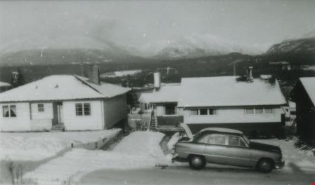
From 4042 Yale Street
https://search.heritageburnaby.ca/link/archivedescription37628
- Repository
- City of Burnaby Archives
- Date
- 1952 (date of original), copied 1991
- Collection/Fonds
- Burnaby Historical Society fonds
- Description Level
- Item
- Physical Description
- 1 photograph : b&w ; 2.9 x 4.8 cm print on contact sheet 20.2 x 25.3 cm
- Scope and Content
- Photograph taken looking north from 4042 Yale Street. Burrard Inlet and the northshore mountains are visible in the background, and there is snow.
- Repository
- City of Burnaby Archives
- Date
- 1952 (date of original), copied 1991
- Collection/Fonds
- Burnaby Historical Society fonds
- Subseries
- Burnaby Image Bank subseries
- Physical Description
- 1 photograph : b&w ; 2.9 x 4.8 cm print on contact sheet 20.2 x 25.3 cm
- Description Level
- Item
- Record No.
- 370-216
- Access Restriction
- No restrictions
- Reproduction Restriction
- No restrictions
- Accession Number
- BHS1999-03
- Scope and Content
- Photograph taken looking north from 4042 Yale Street. Burrard Inlet and the northshore mountains are visible in the background, and there is snow.
- Subjects
- Buildings - Residential - Houses
- Geographic Features - Inlets
- Geographic Features - Mountains
- Media Type
- Photograph
- Notes
- Title based on contents of photograph
- 1 b&w copy negative accompanying
- Geographic Access
- Yale Street
- Street Address
- 4042 Yale Street
- Historic Neighbourhood
- Vancouver Heights (Historic Neighbourhood)
- Planning Study Area
- Burnaby Heights Area
Images

![New Vista Society Housing Projects, [between 1949 and 1957] thumbnail](/media/hpo/_Data/_Archives_Images/_Unrestricted/513/514-013.jpg?width=280)
New Vista Society Housing Projects
https://search.heritageburnaby.ca/link/archivedescription64687
- Repository
- City of Burnaby Archives
- Date
- [between 1949 and 1957]
- Collection/Fonds
- Ernest Winch fonds
- Description Level
- Item
- Physical Description
- 1 photograph : b&w postcard ; 8 x 13 cm
- Scope and Content
- Photographic postcard of an unpaved road lined with New Vista Society Housing Projects.
- Repository
- City of Burnaby Archives
- Date
- [between 1949 and 1957]
- Collection/Fonds
- Ernest Winch fonds
- Physical Description
- 1 photograph : b&w postcard ; 8 x 13 cm
- Description Level
- Item
- Record No.
- 514-013
- Access Restriction
- No restrictions
- Reproduction Restriction
- Reproduce for fair dealing purposes only
- Accession Number
- 2010-06
- Scope and Content
- Photographic postcard of an unpaved road lined with New Vista Society Housing Projects.
- Names
- New Vista Society
- Media Type
- Photograph
- Notes
- Title based on contents of photograph
- Handwritten in border of photograph: "1-2-3"
Images
![New Vista Society Housing Projects, [between 1949 and 1957] thumbnail](/media/hpo/_Data/_Archives_Images/_Unrestricted/513/514-013.jpg)
![Westlawn Drive, [1953] thumbnail](/media/hpo/_Data/_Archives_Images/_Unrestricted/371/401-001.jpg?width=280)
Westlawn Drive
https://search.heritageburnaby.ca/link/archivedescription38304
- Repository
- City of Burnaby Archives
- Date
- [1953]
- Collection/Fonds
- Burnaby Historical Society fonds
- Description Level
- Item
- Physical Description
- 1 photograph : b&w ; 20.3 x 24.8 cm
- Scope and Content
- Photograph of Westlawn Drive, in the Brentwood area, under construction. A number of houses can be seen in various stages of construction and the road is unpaved.
- Repository
- City of Burnaby Archives
- Date
- [1953]
- Collection/Fonds
- Burnaby Historical Society fonds
- Subseries
- Jim Wolf subseries
- Physical Description
- 1 photograph : b&w ; 20.3 x 24.8 cm
- Description Level
- Item
- Record No.
- 401-001
- Access Restriction
- No restrictions
- Reproduction Restriction
- Reproduce for fair dealing purposes only
- Accession Number
- BHS2000-11
- Scope and Content
- Photograph of Westlawn Drive, in the Brentwood area, under construction. A number of houses can be seen in various stages of construction and the road is unpaved.
- Subjects
- Construction
- Geographic Features - Roads
- Media Type
- Photograph
- Notes
- Title based on contents of photograph.
- Geographic Access
- Westlawn Drive
- Planning Study Area
- Brentwood Area
Images
![Westlawn Drive, [1953] thumbnail](/media/hpo/_Data/_Archives_Images/_Unrestricted/371/401-001.jpg)
![Blythe Eagles outside his home, [between 1955 and 1960] (date of original), copied 1996 thumbnail](/media/Hpo/_Data/_Archives_Images/_Unrestricted/205/245-002.jpg?width=280)
Blythe Eagles outside his home
https://search.heritageburnaby.ca/link/archivedescription51540
- Repository
- City of Burnaby Archives
- Date
- [between 1955 and 1960] (date of original), copied 1996
- Collection/Fonds
- Burnaby Historical Society fonds
- Description Level
- Item
- Physical Description
- 1 photograph : b&w copy negative ; 4 x 5.5 cm
- Scope and Content
- Photograph of Blythe Eagles standing in front of the Eagles' estate at Deer Lake.
- Repository
- City of Burnaby Archives
- Date
- [between 1955 and 1960] (date of original), copied 1996
- Collection/Fonds
- Burnaby Historical Society fonds
- Subseries
- Eagles family subseries
- Physical Description
- 1 photograph : b&w copy negative ; 4 x 5.5 cm
- Description Level
- Item
- Record No.
- 245-002
- Access Restriction
- No restrictions
- Reproduction Restriction
- Reproduce for fair dealing purposes only
- Accession Number
- BHS1990-11
- Scope and Content
- Photograph of Blythe Eagles standing in front of the Eagles' estate at Deer Lake.
- Names
- Eagles, Dr. Blythe
- Media Type
- Photograph
- Notes
- Title based on contents of photograph
- 1 b&w ; 12.7 x 17.7 cm print accompanying
- Geographic Access
- Sperling Avenue
- Street Address
- 5655 Sperling Avenue
- Historic Neighbourhood
- Burnaby Lake (Historic Neighbourhood)
- Planning Study Area
- Morley-Buckingham Area
Images
![Blythe Eagles outside his home, [between 1955 and 1960] (date of original), copied 1996 thumbnail](/media/Hpo/_Data/_Archives_Images/_Unrestricted/205/245-002.jpg)

Backyard of 4447 Venables Street
https://search.heritageburnaby.ca/link/archivedescription52358
- Repository
- City of Burnaby Archives
- Date
- 1974
- Collection/Fonds
- Harold H. Johnston fonds
- Description Level
- Item
- Physical Description
- 1 photograph (jpeg) : b&w
- Scope and Content
- Photograph looking east from the backyard of the Johnston family home at 4447 Venables Street. A clothesline draped with clothes can be seen in the background.
- Repository
- City of Burnaby Archives
- Date
- 1974
- Collection/Fonds
- Harold H. Johnston fonds
- Physical Description
- 1 photograph (jpeg) : b&w
- Description Level
- Item
- Record No.
- 483-091
- Access Restriction
- No restrictions
- Reproduction Restriction
- No reproduction permitted
- Accession Number
- 2008-08
- Scope and Content
- Photograph looking east from the backyard of the Johnston family home at 4447 Venables Street. A clothesline draped with clothes can be seen in the background.
- Media Type
- Photograph
- Photographer
- Johnston, Harold H.
- Notes
- Title based on contents of photograph
- Geographic Access
- Venables Street
- Street Address
- 4447 Venables Street
- Historic Neighbourhood
- Vancouver Heights (Historic Neighbourhood)
- Planning Study Area
- Willingdon Heights Area
Images

![From 1855 18th Avenue, [1972 or 1973] (date of original), copied 1991 thumbnail](/media/hpo/_Data/_Archives_Images/_Unrestricted/370/370-262.jpg?width=280)
From 1855 18th Avenue
https://search.heritageburnaby.ca/link/archivedescription37674
- Repository
- City of Burnaby Archives
- Date
- [1972 or 1973] (date of original), copied 1991
- Collection/Fonds
- Burnaby Historical Society fonds
- Description Level
- Item
- Physical Description
- 1 photograph : b&w ; 3.8 x 3.8 cm print on contact sheet 20.2 x 25.3 cm
- Scope and Content
- Photograph taken from the back porch of 1855 18th Avenue (later renumbered as the 7000 block of 18th Avenue) looking west. Houses and mountains are visible.
- Repository
- City of Burnaby Archives
- Date
- [1972 or 1973] (date of original), copied 1991
- Collection/Fonds
- Burnaby Historical Society fonds
- Subseries
- Burnaby Image Bank subseries
- Physical Description
- 1 photograph : b&w ; 3.8 x 3.8 cm print on contact sheet 20.2 x 25.3 cm
- Description Level
- Item
- Record No.
- 370-262
- Access Restriction
- No restrictions
- Reproduction Restriction
- No restrictions
- Accession Number
- BHS1999-03
- Scope and Content
- Photograph taken from the back porch of 1855 18th Avenue (later renumbered as the 7000 block of 18th Avenue) looking west. Houses and mountains are visible.
- Media Type
- Photograph
- Notes
- Title based on contents of photograph
- 1 b&w copy negative accompanying
- Negative has a pink cast
- Copied from col. photograph
- Geographic Access
- 18th Avenue
- Historic Neighbourhood
- Edmonds (Historic Neighbourhood)
- Planning Study Area
- Stride Avenue Area
Images
![From 1855 18th Avenue, [1972 or 1973] (date of original), copied 1991 thumbnail](/media/hpo/_Data/_Archives_Images/_Unrestricted/370/370-262.jpg)
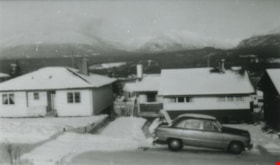
From 4042 Yale Street
https://search.heritageburnaby.ca/link/archivedescription37627
- Repository
- City of Burnaby Archives
- Date
- 1952 (date of original), copied 1991
- Collection/Fonds
- Burnaby Historical Society fonds
- Description Level
- Item
- Physical Description
- 1 photograph : b&w ; 2.8 x 4.8 cm print on contact sheet 20.2 x 25.3 cm
- Scope and Content
- Photograph taken looking north from 4042 Yale Street. The northshore mountains are visible in the background. There is snow.
- Repository
- City of Burnaby Archives
- Date
- 1952 (date of original), copied 1991
- Collection/Fonds
- Burnaby Historical Society fonds
- Subseries
- Burnaby Image Bank subseries
- Physical Description
- 1 photograph : b&w ; 2.8 x 4.8 cm print on contact sheet 20.2 x 25.3 cm
- Description Level
- Item
- Record No.
- 370-215
- Access Restriction
- No restrictions
- Reproduction Restriction
- No restrictions
- Accession Number
- BHS1999-03
- Scope and Content
- Photograph taken looking north from 4042 Yale Street. The northshore mountains are visible in the background. There is snow.
- Media Type
- Photograph
- Notes
- Title based on contents of photograph
- 1 b&w copy negative accompanying
- Geographic Access
- Yale Street
- Street Address
- 4042 Yale Street
- Historic Neighbourhood
- Vancouver Heights (Historic Neighbourhood)
- Planning Study Area
- Burnaby Heights Area
Images

Lubbock's farm house and parking lot
https://search.heritageburnaby.ca/link/archivedescription36515
- Repository
- City of Burnaby Archives
- Date
- 1977
- Collection/Fonds
- Burnaby Historical Society fonds
- Description Level
- Item
- Physical Description
- 1 photograph : col. ; 9 x 8.5 cm
- Scope and Content
- Photograph of the side of Lubbock's farm house. Horses are being lead across the parking lot, between the parked Datsun automobiles at the entrance to the farm off of Canada Way. Both the Burnaby Lake Riding Academy and the Burnaby Lake Riding Club operated out of the Lubbock farm.
- Repository
- City of Burnaby Archives
- Date
- 1977
- Collection/Fonds
- Burnaby Historical Society fonds
- Subseries
- Lubbock family subseries
- Physical Description
- 1 photograph : col. ; 9 x 8.5 cm
- Description Level
- Item
- Record No.
- 289-004
- Access Restriction
- No restrictions
- Reproduction Restriction
- Reproduce for fair dealing purposes only
- Accession Number
- BHS1992-24
- Scope and Content
- Photograph of the side of Lubbock's farm house. Horses are being lead across the parking lot, between the parked Datsun automobiles at the entrance to the farm off of Canada Way. Both the Burnaby Lake Riding Academy and the Burnaby Lake Riding Club operated out of the Lubbock farm.
- Media Type
- Photograph
- Notes
- Title based on contents of photograph
- Geographic Access
- Grandview Highway
- Canada Way
- Burris Street
- Street Address
- 7803 Burris Street
- Historic Neighbourhood
- Burnaby Lake (Historic Neighbourhood)
- Planning Study Area
- Morley-Buckingham Area
Images
