Narrow Results By

Frank Walsh Residence
https://search.heritageburnaby.ca/link/landmark581
- Repository
- Burnaby Heritage Planning
- Description
- Residential building.
- Associated Dates
- 1948
- Street View URL
- Google Maps Street View
- Repository
- Burnaby Heritage Planning
- Geographic Access
- Boundary Road
- Associated Dates
- 1948
- Description
- Residential building.
- Heritage Value
- This Streamline Moderne house is a rare example of this style in Burnaby and remains in excellent condition. Reflecting the influence of technology, industrial design and aerodynamic styling, the house has smooth rounded surfaces, rounded corners, a flat roof and prominent projecting eaves. It was built for prominent North Burnaby businessman Frank Wallace Walsh (1907-1963), who was a mechanic, and his wife Rena.
- Locality
- Vancouver Heights
- Historic Neighbourhood
- Vancouver Heights (Historic Neighbourhood)
- Planning Study Area
- Burnaby Heights Area
- Area
- 566.71
- Contributing Resource
- Building
- Ownership
- Private
- Street Address
- 270 Boundary Road
- Street View URL
- Google Maps Street View
Images


![Shull Lumber and Shingle Company, [194-] thumbnail](/media/hpo/_Data/_Archives_Images/_Unrestricted/001/090-001.jpg?width=280)
Shull Lumber and Shingle Company
https://search.heritageburnaby.ca/link/archivedescription34674
- Repository
- City of Burnaby Archives
- Date
- [194-]
- Collection/Fonds
- Burnaby Historical Society fonds
- Description Level
- Item
- Physical Description
- 1 photograph : b&w ; 19.5 x 24.6 cm
- Scope and Content
- Photograph of the Shull Lumber and Shingle Company at the foot of Boundary Road.
- Repository
- City of Burnaby Archives
- Date
- [194-]
- Collection/Fonds
- Burnaby Historical Society fonds
- Subseries
- Photographs subseries
- Physical Description
- 1 photograph : b&w ; 19.5 x 24.6 cm
- Description Level
- Item
- Record No.
- 090-001
- Access Restriction
- No restrictions
- Reproduction Restriction
- Reproduce for fair dealing purposes only
- Accession Number
- BHS2007-04
- Scope and Content
- Photograph of the Shull Lumber and Shingle Company at the foot of Boundary Road.
- Media Type
- Photograph
- Photographer
- Steffens-Colmer Limited
- Notes
- Title based on contents of photograph
- Embossed at front lower right of photograph, "Steffens-Colmer Photo"
- Stamped and annotated on back of photograph, "Steffens-Colmer Ltd. / 560 Granville Street / Vancouver, B.C. / No. 52832-1"
- Geographic Access
- Boundary Road
- Historic Neighbourhood
- Fraser Arm (Historic Neighbourhood)
- Planning Study Area
- Big Bend Area
Images
![Shull Lumber and Shingle Company, [194-] thumbnail](/media/hpo/_Data/_Archives_Images/_Unrestricted/001/090-001.jpg)

Switchboard
https://search.heritageburnaby.ca/link/archivedescription34710
- Repository
- City of Burnaby Archives
- Date
- 1943
- Collection/Fonds
- Burnaby Historical Society fonds
- Description Level
- Item
- Physical Description
- 1 photograph : b&w ; 20.0 x 25.5 cm
- Scope and Content
- Photograph of the interior of a switchboard, probably the Dexter exchange at Boundary Road and Kingsway. A typed description on the back of the photograph reads, "A Manual Switchboard, typical of about 25 years ago. / Dexter, 1943. / B.C. Telephone Company."
- Repository
- City of Burnaby Archives
- Date
- 1943
- Collection/Fonds
- Burnaby Historical Society fonds
- Subseries
- Photographs subseries
- Physical Description
- 1 photograph : b&w ; 20.0 x 25.5 cm
- Material Details
- Printed on photo paper: "selo"
- Description Level
- Item
- Record No.
- 114-001
- Access Restriction
- No restrictions
- Reproduction Restriction
- No known restrictions
- Accession Number
- BHS2007-04
- Scope and Content
- Photograph of the interior of a switchboard, probably the Dexter exchange at Boundary Road and Kingsway. A typed description on the back of the photograph reads, "A Manual Switchboard, typical of about 25 years ago. / Dexter, 1943. / B.C. Telephone Company."
- Subjects
- Telecommunication Tools and Equipment
- Buildings - Commercial
- Occupations - Telephone Operators
- Media Type
- Photograph
- Photographer
- Dominion Photo Company
- Notes
- Title based on contents of photograph
- Printed in bottom left corner of photograph, "27038 Dominion Photo Co., Vancouver B.C."
- Geographic Access
- Boundary Road
- Kingsway
- Historic Neighbourhood
- Central Park (Historic Neighbourhood)
- Planning Study Area
- Garden Village Area
Images

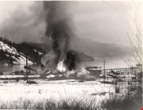
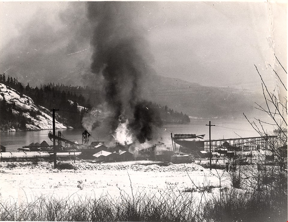
Fire at Kapoor Sawmills Ltd.
https://search.heritageburnaby.ca/link/museumdescription15202
- Repository
- Burnaby Village Museum
- Date
- 14 Jan. 1947 (date of original), copied 2004
- Collection/Fonds
- In the Shadow by the Sea collection
- Description Level
- Item
- Physical Description
- 1 photograph (tiff) : 300 dpi
- Scope and Content
- Photograph of a devasting fire that destroyed the Kapoor Sawmills Limited on January 14, 1947. The ground is covered with snow and smoke and flames are visible rising from the buildings.
- Repository
- Burnaby Village Museum
- Collection/Fonds
- In the Shadow by the Sea collection
- Description Level
- Item
- Physical Description
- 1 photograph (tiff) : 300 dpi
- Scope and Content
- Photograph of a devasting fire that destroyed the Kapoor Sawmills Limited on January 14, 1947. The ground is covered with snow and smoke and flames are visible rising from the buildings.
- Names
- Kapoor Sawmills Limited
- Geographic Access
- Burrard Inlet
- Barnet Marine Park
- Accession Code
- BV019.32.23
- Access Restriction
- No restrictions
- Reproduction Restriction
- May be restricted by third party rights
- Date
- 14 Jan. 1947 (date of original), copied 2004
- Media Type
- Photograph
- Historic Neighbourhood
- Barnet (Historic Neighbourhood)
- Planning Study Area
- Burnaby Mountain Area
- Notes
- Title based on contents of photograph
- Information from page 6 of The Province newspaper-Jan. 15, 1947 confirms that the fire occurred on Tuesday, January 14, 1947
- See page 67 of book "In the Shadow by the Sea - Recollections of Burnaby's Barnet Village". Caption with photograph reads: "The February, 1947 Kapoor Sawmill fire. Maintenance workers were trying to thaw out frozen bearings on a machine with a blowtorch and inadvertently started a fire in oily shavings. all the water pipes were frozen preventing the workers from dousing the intital small flames. Finally, but toolate to prevent the mill's destruction, water was pumped in from the inlet by the Burnaby Fire Department."
Images
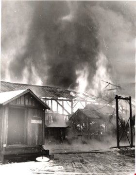
Fire at Kapoor Sawmills Ltd.
https://search.heritageburnaby.ca/link/museumdescription15209
- Repository
- Burnaby Village Museum
- Date
- 14 Jan.1947 (date of original), copied 2004
- Collection/Fonds
- In the Shadow by the Sea collection
- Description Level
- Item
- Physical Description
- 1 photograph (tiff) : 300 dpi
- Scope and Content
- Photograph of a fire at the Kapoor Sawmills Limited on January 14, 1947. Mill buildings are engulfed in flames. There is snow on the ground.
- Repository
- Burnaby Village Museum
- Collection/Fonds
- In the Shadow by the Sea collection
- Description Level
- Item
- Physical Description
- 1 photograph (tiff) : 300 dpi
- Scope and Content
- Photograph of a fire at the Kapoor Sawmills Limited on January 14, 1947. Mill buildings are engulfed in flames. There is snow on the ground.
- Geographic Access
- Burrard Inlet
- Barnet Marine Park
- Accession Code
- BV019.32.29
- Access Restriction
- No restrictions
- Reproduction Restriction
- May be restricted by third party rights
- Date
- 14 Jan.1947 (date of original), copied 2004
- Media Type
- Photograph
- Historic Neighbourhood
- Barnet (Historic Neighbourhood)
- Planning Study Area
- Burnaby Mountain Area
- Notes
- Title based on contents of photograph
- Information from page 6 of The Province newspaper-Jan. 15, 1947 confirms that the fire occurred on Tuesday January 14, 1947
Images

![Building and opening the Digney Speedway, [between 1948 and 1949] thumbnail](/media/Hpo/_Data/_Archives_Moving_Images/_Unrestricted/562-003-16.jpg?width=280)
Building and opening the Digney Speedway
https://search.heritageburnaby.ca/link/archivedescription85334
- Repository
- City of Burnaby Archives
- Date
- [between 1948 and 1949]
- Collection/Fonds
- Digney Family fonds
- Description Level
- Item
- Physical Description
- 1 film clip (10 min., 47sec.) : digital, b&w, col., si.
- Scope and Content
- Item is a digitized silent film segment identified as Reel 16. The film footage shows land being cleared to make way for the Digney Speedway located near the corner of Irmin Street and MacPherson Avenue, one of the men seen in this footage clearing the land is named Lucky Fordham. The film continue…
- Repository
- City of Burnaby Archives
- Date
- [between 1948 and 1949]
- Collection/Fonds
- Digney Family fonds
- Physical Description
- 1 film clip (10 min., 47sec.) : digital, b&w, col., si.
- Description Level
- Item
- Record No.
- 562-003-16
- Access Restriction
- No restrictions
- Reproduction Restriction
- May be restricted by third party rights
- Accession Number
- 2014-04
- Scope and Content
- Item is a digitized silent film segment identified as Reel 16. The film footage shows land being cleared to make way for the Digney Speedway located near the corner of Irmin Street and MacPherson Avenue, one of the men seen in this footage clearing the land is named Lucky Fordham. The film continues with footage of a press dinner in the garden of Andy Digney's home on Bonsor Avenue in Burnaby and is followed with footage of the Digney Speedway in operation for the grand opening on July 8, 1948. Midget cars and jalopies (stock cars) can be seen racing on the speedway. Some of the footage of the raceway pit and races switches to black and white.The film closes with colour footage of a truck moving Lucky Fordham's house from Bonsor Ave to the speedway.
- Subjects
- Sports - Automobile Racing
- Media Type
- Moving Images
- Photographer
- Digney, Andy
- Creator
- Digney, Andy
- Notes
- Title based on contents of film
- Geographic Access
- Bonsor Avenue
- Historic Neighbourhood
- Alta-Vista (Historic Neighbourhood)
- Central Park (Historic Neighbourhood)
- Planning Study Area
- Clinton-Glenwood Area
- Maywood Area
Images
![Building and opening the Digney Speedway, [between 1948 and 1949] thumbnail](/media/Hpo/_Data/_Archives_Moving_Images/_Unrestricted/562-003-16.jpg)
Video
Building and opening the Digney Speedway, [between 1948 and 1949]
Building and opening the Digney Speedway, [between 1948 and 1949]
https://search.heritageburnaby.ca/media/hpo/_Data/_Archives_Moving_Images/_Unrestricted/562-003-16.m4v