Narrow Results By
Burnaby North High School
https://search.heritageburnaby.ca/link/landmark745
- Repository
- Burnaby Heritage Planning
- Associated Dates
- 1923-1982
- Street View URL
- Google Maps Street View
- Repository
- Burnaby Heritage Planning
- Geographic Access
- Willingdon Avenue
- Associated Dates
- 1923-1982
- Heritage Value
- Burnaby North and Burnaby South were the first high schools built in the City. Before the high school opened, Burnaby students had to travel to Vancouver if they wished to pursue education beyond an elementary level. In 1921, arrangements were made to use the basement of the Presbyterian Church for instruction of local students. By 1922 the Burnaby North High School opened at its first permanent location (4375 Pandora Street - which is now Rosser Elementary). In 1945, the Willingdon Avenue site was built and was used until a new building was constructed in 1961 on Hammarskjold Drive. From 1962, the school was used as Burnaby Heights Junior High school, but it closed in 1982 and the junior high students went to the new Burnaby North on Hammarskjold.
- Historic Neighbourhood
- Capitol Hill (Historic Neighbourhood)
- Planning Study Area
- Capitol Hill Area
- Street Address
- 250 Willingdon Avenue
- Street View URL
- Google Maps Street View
Images
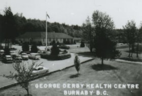
George Derby Centre
https://search.heritageburnaby.ca/link/landmark705
- Repository
- Burnaby Heritage Planning
- Geographic Access
- Cumberland Street
- Associated Dates
- 1947
- Heritage Value
- The George Derby Centre was opened in 1947 as a rehabilitation Centre for young disabled veterans returning from the war. The centre was named after George Cleveland Derby, a World War I veteran who was injured in the Battle of Vimy Ridge and later went on to become a District Administrator in the Department of Solders’ Civil Re-establishment, the forerunner of the Department of Veterans Affairs. His work took him to wartime England where he was awarded the Order of the British Empire in 1943 for patriotic and philanthropic work.
- Historic Neighbourhood
- East Burnaby (Historic Neighbourhood)
- Planning Study Area
- Cariboo-Armstrong Area
- Street Address
- 7550 Cumberland Street
- Street View URL
- Google Maps Street View

