More like 'Montreal Bank and Post Office'
Narrow Results By
Decade
- 2020s 119
- 2010s 118
- 2000s
- 1990s 641
- 1980s 486
- 1970s 946
- 1960s 378
- 1950s 544
- 1940s
- 1930s 608
- 1920s 651
- 1910s 605
- 1900s 270
- 1890s 36
- 1880s 69
- 1870s 5
- 1860s 3
- 1850s 1
- 1840s 1
- 1830s 1
- 1820s 1
- 1810s 1
- 1800s 1
- 1790s 1
- 1780s 1
- 1770s 1
- 1760s 1
- 1750s 1
- 1740s 1
- 1730s 1
- 1720s 1
- 1710s 1
- 1700s 1
- 1690s 1
- 1680s 1
- 1670s 1
- 1660s 1
- 1650s 1
- 1640s 1
- 1630s 1
- 1620s 1
- 1610s 1
- 1600s 1
Subject
- Accidents - Automobile Accidents 2
- Advertising Medium 1
- Advertising Medium - Signs and Signboards 11
- Aerial Photographs 6
- Agricultural Tools and Equipment - Plows 1
- Agriculture 3
- Agriculture - Farms 4
- Agriculture - Fruit and Berries 2
- Animals - Bears 2
- Animals - Birds 4
- Animals - Cats 1
- Animals - Deer 1
Person / Organization
- 5th Burnaby Brownie Pack 1
- Alfred Horie Construction Company Limited 2
- Allen, Cecil 1
- Allen, Marjorie 1
- Allen, Stephanie 2
- All Saints Anglican Church 1
- Alpha Secondary School 2
- Alta Vista Baptist Church 1
- A. MacKenzie and Company Jubilee Store 3
- Amundsen, Dave 1
- Anderson, Harry 1
- Anderson, Madelaine Carroll 1
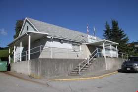
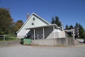
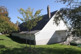
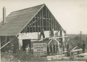
Capitol Hill Community Hall
https://search.heritageburnaby.ca/link/landmark563
- Repository
- Burnaby Heritage Planning
- Description
- Public building.
- Associated Dates
- 1948
- Street View URL
- Google Maps Street View
- Repository
- Burnaby Heritage Planning
- Geographic Access
- Howard Avenue
- Associated Dates
- 1948
- Description
- Public building.
- Heritage Value
- The Capitol Hill Community Hall was designed by local architect Harold Cullerne (1890-1976). After Cullerne returned from service during the First World War, he joined J.H. Bowman in a partnership that lasted from 1919 to 1934. After Bowman retired in 1934, Cullerne practiced on his own, continuing to work on schools and institutional buildings, such as the Art Deco Hollywood Theatre in Vancouver. In 1944, Cullerne designed a community hall for Capitol Hill; the scheme was delayed, and redesigned before it was finally built after the end of the Second World War. A simple front gabled roof hall structure, this hall is a monument to community spirit, erected by community members on a volunteer basis, and used for community events for over half a century. The hall replaced two earlier structures, both destroyed by fire, that had served the same purpose.
- Locality
- Capitol Hill
- Historic Neighbourhood
- Capitol Hill (Historic Neighbourhood)
- Planning Study Area
- Capitol Hill Area
- Architect
- Harold Cullerne
- Ownership
- Public (local)
- Street Address
- 361 Howard Avenue
- Street View URL
- Google Maps Street View
Images
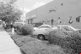
3700 block of Hastings Street
https://search.heritageburnaby.ca/link/archivedescription97940
- Repository
- City of Burnaby Archives
- Date
- [2000]
- Collection/Fonds
- Burnaby NewsLeader photograph collection
- Description Level
- Item
- Physical Description
- 1 photograph (tiff) : b&w
- Scope and Content
- Photograph of the 3700 block of Hastings Street in North Burnaby, looking southeast. Kato Japanese Chinese Restaurant is one of the visible businesses and some snow is on the ground.
- Repository
- City of Burnaby Archives
- Date
- [2000]
- Collection/Fonds
- Burnaby NewsLeader photograph collection
- Physical Description
- 1 photograph (tiff) : b&w
- Description Level
- Item
- Record No.
- 535-3066
- Access Restriction
- No restrictions
- Reproduction Restriction
- No restrictions
- Accession Number
- 2018-12
- Scope and Content
- Photograph of the 3700 block of Hastings Street in North Burnaby, looking southeast. Kato Japanese Chinese Restaurant is one of the visible businesses and some snow is on the ground.
- Subjects
- Geographic Features - Roads
- Buildings - Commercial
- Buildings - Commercial - Restaurants
- Buildings - Residential
- Media Type
- Photograph
- Notes
- Title based on contents of photograph
- Collected by editorial for use in a January 2000 issue of the Burnaby NewsLeader
- Geographic Access
- Hastings Street
- Street Address
- 3700 Hastings Street
- Historic Neighbourhood
- Vancouver Heights (Historic Neighbourhood)
- Planning Study Area
- Burnaby Heights Area
Images
Wendy Jenkinson outside of the Swap Centre
https://search.heritageburnaby.ca/link/archivedescription98004
- Repository
- City of Burnaby Archives
- Date
- [2000]
- Collection/Fonds
- Burnaby NewsLeader photograph collection
- Description Level
- Item
- Physical Description
- 1 photograph (tiff) : col.
- Scope and Content
- Photograph of Wendy Jenkinson standing outside of the Swap Centre on Hastings Street.
- Repository
- City of Burnaby Archives
- Date
- [2000]
- Collection/Fonds
- Burnaby NewsLeader photograph collection
- Physical Description
- 1 photograph (tiff) : col.
- Description Level
- Item
- Record No.
- 535-3108
- Access Restriction
- No restrictions
- Reproduction Restriction
- No restrictions
- Accession Number
- 2018-12
- Scope and Content
- Photograph of Wendy Jenkinson standing outside of the Swap Centre on Hastings Street.
- Media Type
- Photograph
- Photographer
- Bartel, Mario
- Notes
- Title based on caption
- Collected by editorial for use in a February 2000 issue of the Burnaby NewsLeader
- Caption from metadata: "Wendy Jenkinson says the area around the Swap Centre on Hastings St. is usually packed with cars on the weekend, overflowing onto her street."
- Geographic Access
- Hastings Street
- Street Address
- 6011 Hastings Street
- Historic Neighbourhood
- Capitol Hill (Historic Neighbourhood)
- Planning Study Area
- Capitol Hill Area
Images
Credit union employee
https://search.heritageburnaby.ca/link/archivedescription95713
- Repository
- City of Burnaby Archives
- Date
- [2001]
- Collection/Fonds
- Burnaby NewsLeader photograph collection
- Description Level
- Item
- Physical Description
- 1 photograph (tiff) : col.
- Scope and Content
- Photograph of a credit union employee holding multiple brochures toward the camera. The employee stands in front of a large poster and pamphlet kiosk that reads: "There's no time like the present to plan for your financial future."
- Repository
- City of Burnaby Archives
- Date
- [2001]
- Collection/Fonds
- Burnaby NewsLeader photograph collection
- Physical Description
- 1 photograph (tiff) : col.
- Description Level
- Item
- Record No.
- 535-1571
- Access Restriction
- No restrictions
- Reproduction Restriction
- No restrictions
- Accession Number
- 2018-12
- Scope and Content
- Photograph of a credit union employee holding multiple brochures toward the camera. The employee stands in front of a large poster and pamphlet kiosk that reads: "There's no time like the present to plan for your financial future."
- Subjects
- Buildings - Commercial - Banks
- Media Type
- Photograph
- Photographer
- Bartel, Mario
- Notes
- Title based on caption
- Collected by editorial for use in a January 2001 issue of the Burnaby NewsLeader
- Caption from metadata: "David Badley, an investment advisor at the Westminster Credit Union, shows some of the RRSP plans which are available."
Images
Emanuel Sandhu signing autographs
https://search.heritageburnaby.ca/link/archivedescription96660
- Repository
- City of Burnaby Archives
- Date
- [2003]
- Collection/Fonds
- Burnaby NewsLeader photograph collection
- Description Level
- File
- Physical Description
- 2 photographs (tiff) : col.
- Scope and Content
- File contains photographs of Emanuel Sandhu, the 2003 Canadian Men's Figure Skating Champion, signing autographs at the Bank of Montreal in the Metrotown Centre. Photographs depict Sandhu with Kelsey Vriend of Abbotsford and with other unidentified autograph-seekers.
- Repository
- City of Burnaby Archives
- Date
- [2003]
- Collection/Fonds
- Burnaby NewsLeader photograph collection
- Physical Description
- 2 photographs (tiff) : col.
- Description Level
- File
- Record No.
- 535-2282
- Access Restriction
- No restrictions
- Reproduction Restriction
- No restrictions
- Accession Number
- 2018-12
- Scope and Content
- File contains photographs of Emanuel Sandhu, the 2003 Canadian Men's Figure Skating Champion, signing autographs at the Bank of Montreal in the Metrotown Centre. Photographs depict Sandhu with Kelsey Vriend of Abbotsford and with other unidentified autograph-seekers.
- Names
- Metrotown
- Media Type
- Photograph
- Photographer
- Bartel, Mario
- Notes
- Title based on caption
- Collected by editorial for use in a March 2003 issue of the Burnaby NewsLeader
- Caption from metadata for 535-2282-1: "Emanuel Sandhu, the 2003 Canadian Men's Figure Skating Champion, signs an autograph for Kelsey Vriend, of Abbotsford, during an appearnce at the Bank of Montreal in the Metrotown Centre. Vriend was the top fundraiser in the Community Skate-A-Thons to Support Kids and she won a trip for two to the World Figure Skating Championships, in Washington D.C."
- Caption from metadata for 535-2282-2: "Emanual Sandhu, 2003 Canadian Men's Figure Skating Champion, signs autographs for fans during an appearance at the Bank of Montreal in the Metrotown Centre. Sandhu, who trains at Burnaby 8 Rinks, is preparing for the World Figure Skating Championships, March 27-30 in Washington DC."
- Geographic Access
- Kingsway
- Street Address
- 4700 Kingsway
- Historic Neighbourhood
- Central Park (Historic Neighbourhood)
- Planning Study Area
- Maywood Area
Images
"Welcome to the Heights" mural
https://search.heritageburnaby.ca/link/archivedescription96859
- Repository
- City of Burnaby Archives
- Date
- [2000]
- Collection/Fonds
- Burnaby NewsLeader photograph collection
- Description Level
- Item
- Physical Description
- 1 photograph (tiff) : b&w
- Scope and Content
- Photograph of the "Welcome to the Heights" mural on the exterior of the HSBC bank on the corner of Hastings and Gilmore in North Burnaby.
- Repository
- City of Burnaby Archives
- Date
- [2000]
- Collection/Fonds
- Burnaby NewsLeader photograph collection
- Physical Description
- 1 photograph (tiff) : b&w
- Description Level
- Item
- Record No.
- 535-2417
- Access Restriction
- No restrictions
- Reproduction Restriction
- No restrictions
- Accession Number
- 2018-12
- Scope and Content
- Photograph of the "Welcome to the Heights" mural on the exterior of the HSBC bank on the corner of Hastings and Gilmore in North Burnaby.
- Media Type
- Photograph
- Notes
- Title based on contents of photograph
- Collected by editorial for use in a May 2000 issue of the Burnaby NewsLeader
- Geographic Access
- Hastings Street
- Gilmore Avenue
- Historic Neighbourhood
- Vancouver Heights (Historic Neighbourhood)
- Planning Study Area
- Burnaby Heights Area
Images
Banff, Alberta
https://search.heritageburnaby.ca/link/museumdescription3411
- Repository
- Burnaby Village Museum
- Date
- [1944]
- Collection/Fonds
- Burnaby Village Museum Photograph collection
- Description Level
- Item
- Physical Description
- 1 photograph : b&w ; 10 x 6 cm
- Scope and Content
- Photograph of Mount Lougheed, taken looking north, from the main street in Banff.
- Repository
- Burnaby Village Museum
- Collection/Fonds
- Burnaby Village Museum Photograph collection
- Description Level
- Item
- Physical Description
- 1 photograph : b&w ; 10 x 6 cm
- Scope and Content
- Photograph of Mount Lougheed, taken looking north, from the main street in Banff.
- Accession Code
- BV005.30.33
- Access Restriction
- No restrictions
- Date
- [1944]
- Media Type
- Photograph
- Scan Date
- 1/19/2010
- Photographer
- Battersby, Frank
- Notes
- Title based on contents of photograph
Images
Dover Street crosswalk lights
https://search.heritageburnaby.ca/link/archivedescription97008
- Repository
- City of Burnaby Archives
- Date
- [2000]
- Collection/Fonds
- Burnaby NewsLeader photograph collection
- Description Level
- Item
- Physical Description
- 1 photograph (tiff) : col.
- Scope and Content
- Photograph of the assistant director of traffic engineering at the City of Burnaby examining a piece of equipment installed in Dover Street as part of a pilot project for new crosswalk lights. A school crosswalk sign and passing vehicle are visible in the background.
- Repository
- City of Burnaby Archives
- Date
- [2000]
- Collection/Fonds
- Burnaby NewsLeader photograph collection
- Physical Description
- 1 photograph (tiff) : col.
- Description Level
- Item
- Record No.
- 535-2540
- Access Restriction
- No restrictions
- Reproduction Restriction
- No restrictions
- Accession Number
- 2018-12
- Scope and Content
- Photograph of the assistant director of traffic engineering at the City of Burnaby examining a piece of equipment installed in Dover Street as part of a pilot project for new crosswalk lights. A school crosswalk sign and passing vehicle are visible in the background.
- Subjects
- Geographic Features - Roads
- Geographic Features - Sidewalks
- Occupations - Civic Workers
- Public Services - Public Works
- Media Type
- Photograph
- Photographer
- Bartel, Mario
- Notes
- Title based on caption
- Collected by editorial for use in a July 2000 issue of the Burnaby NewsLeader
- Caption from metadata: "Burnaby's assistand director of traffic engineering examines the new crosswalk lights, installed as a pilot project, on Dover, between Royal Oak and Nelson."
- Geographic Access
- Dover Street
- Nelson Avenue
- Royal Oak Avenue
- Historic Neighbourhood
- Central Park (Historic Neighbourhood)
- Planning Study Area
- Marlborough Area
Images
Mickey McGuire and Jack Nichols
https://search.heritageburnaby.ca/link/archivedescription38149
- Repository
- City of Burnaby Archives
- Date
- [between 1940 and 1944] (date of original), copied 1991
- Collection/Fonds
- Burnaby Historical Society fonds
- Description Level
- Item
- Physical Description
- 1 photograph : b&w ; 2.6 x 4.2 cm print on contact sheet 20.6 x 26.8 cm
- Scope and Content
- Photograph of Mickey McGuire (back) and Jack Nichols (front) on the 4000 block Kingsway (later renumbered the 4500 block) at McKay Avenue.
- Repository
- City of Burnaby Archives
- Date
- [between 1940 and 1944] (date of original), copied 1991
- Collection/Fonds
- Burnaby Historical Society fonds
- Subseries
- Burnaby Image Bank subseries
- Physical Description
- 1 photograph : b&w ; 2.6 x 4.2 cm print on contact sheet 20.6 x 26.8 cm
- Description Level
- Item
- Record No.
- 370-736
- Access Restriction
- No restrictions
- Reproduction Restriction
- No restrictions
- Accession Number
- BHS1999-03
- Scope and Content
- Photograph of Mickey McGuire (back) and Jack Nichols (front) on the 4000 block Kingsway (later renumbered the 4500 block) at McKay Avenue.
- Names
- McGuire, Mickey
- Nichols, Jack
- Media Type
- Photograph
- Notes
- Title based on contents of photograph
- 1 b&w copy negative accompanying
- Negative has a pink cast
- Geographic Access
- Kingsway
- Historic Neighbourhood
- Central Park (Historic Neighbourhood)
- Planning Study Area
- Maywood Area
- Marlborough Area
Images
Mickey McGuire and Jack Nichols
https://search.heritageburnaby.ca/link/archivedescription38150
- Repository
- City of Burnaby Archives
- Date
- [between 1940 and 1944] (date of original), copied 1991
- Collection/Fonds
- Burnaby Historical Society fonds
- Description Level
- Item
- Physical Description
- 1 photograph : b&w ; 4.1 x 2.6 cm print on contact sheet 20.6 x 26.8 cm
- Scope and Content
- Photograph of Mickey McGuire (back) and Jack Nichols (front) on the 4000 block Kingsway (later renumbered the 4500 block) at McKay Avenue.
- Repository
- City of Burnaby Archives
- Date
- [between 1940 and 1944] (date of original), copied 1991
- Collection/Fonds
- Burnaby Historical Society fonds
- Subseries
- Burnaby Image Bank subseries
- Physical Description
- 1 photograph : b&w ; 4.1 x 2.6 cm print on contact sheet 20.6 x 26.8 cm
- Description Level
- Item
- Record No.
- 370-737
- Access Restriction
- No restrictions
- Reproduction Restriction
- No restrictions
- Accession Number
- BHS1999-03
- Scope and Content
- Photograph of Mickey McGuire (back) and Jack Nichols (front) on the 4000 block Kingsway (later renumbered the 4500 block) at McKay Avenue.
- Names
- McGuire, Mickey
- Nichols, Jack
- Media Type
- Photograph
- Notes
- Title based on contents of photograph
- 1 b&w copy negative accompanying
- Negative has a pink cast
- Caption at bottom of photograph reads, "Mickey McGuire and Jack Nichols"
- Geographic Access
- Kingsway
- Historic Neighbourhood
- Central Park (Historic Neighbourhood)
- Planning Study Area
- Maywood Area
- Marlborough Area
Images
6100 Block Kathleen Avenue
https://search.heritageburnaby.ca/link/archivedescription37653
- Repository
- City of Burnaby Archives
- Date
- [1943 or 1944] (date of original), copied 1991
- Collection/Fonds
- Burnaby Historical Society fonds
- Description Level
- Item
- Physical Description
- 1 photograph : b&w ; 3.1 x 4.5 cm print on contact sheet 20.2 x 25.3 cm
- Scope and Content
- Photograph taken looking north on Kathleen Avenue from the 6100 block of Kathleen Avenue after a snowfall.
- Repository
- City of Burnaby Archives
- Date
- [1943 or 1944] (date of original), copied 1991
- Collection/Fonds
- Burnaby Historical Society fonds
- Subseries
- Burnaby Image Bank subseries
- Physical Description
- 1 photograph : b&w ; 3.1 x 4.5 cm print on contact sheet 20.2 x 25.3 cm
- Description Level
- Item
- Record No.
- 370-241
- Access Restriction
- No restrictions
- Reproduction Restriction
- No known restrictions
- Accession Number
- BHS1999-03
- Scope and Content
- Photograph taken looking north on Kathleen Avenue from the 6100 block of Kathleen Avenue after a snowfall.
- Media Type
- Photograph
- Notes
- Title based on contents of photograph
- 1 b&w copy negative accompanying
- Negative has a pink cast
- Geographic Access
- Kathleen Avenue
- Historic Neighbourhood
- Central Park (Historic Neighbourhood)
- Planning Study Area
- Maywood Area
Images
Brantford Elementary school crosswalk
https://search.heritageburnaby.ca/link/archivedescription96384
- Repository
- City of Burnaby Archives
- Date
- [2004]
- Collection/Fonds
- Burnaby NewsLeader photograph collection
- Description Level
- Item
- Physical Description
- 1 photograph (tiff) : col.
- Scope and Content
- Photograph of Ernie Kashima, the principal of Brantford Elementary School, standing at a school crosswalk at Sperling Avenue near the elementary school.
- Repository
- City of Burnaby Archives
- Date
- [2004]
- Collection/Fonds
- Burnaby NewsLeader photograph collection
- Physical Description
- 1 photograph (tiff) : col.
- Description Level
- Item
- Record No.
- 535-2054
- Access Restriction
- No restrictions
- Reproduction Restriction
- No restrictions
- Accession Number
- 2018-12
- Scope and Content
- Photograph of Ernie Kashima, the principal of Brantford Elementary School, standing at a school crosswalk at Sperling Avenue near the elementary school.
- Media Type
- Photograph
- Photographer
- Bartel, Mario
- Notes
- Title based on caption
- Collected by editorial for use in a March 2004 issue of the Burnaby NewsLeader
- Caption from metadata: "Ernie Kashima, the principal of Brantford Elementary School, says he pulled his school's student crossing guards from a crossing on Sperling Ave. because of fears for the guards' safety, as the street doesn't have a school speed zone."
- Geographic Access
- Sperling Avenue
- Brantford Avenue
- Street Address
- 6512 Brantford Avenue
- Historic Neighbourhood
- Edmonds (Historic Neighbourhood)
- Planning Study Area
- Kingsway-Beresford Area
Images
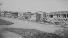
Charles Street and Gilmore Avenue
https://search.heritageburnaby.ca/link/archivedescription34176
- Repository
- City of Burnaby Archives
- Date
- May 9, 1947
- Collection/Fonds
- Burnaby Historical Society fonds
- Description Level
- Item
- Physical Description
- 1 photograph : b&w negative ; 6.8 x 11.5 cm
- Scope and Content
- Photograph of the Charles Street and Gilmore Avenue intersection with houses under construction on the right side of the street. This is part of the Willingdon Heights subdivision site.
- Repository
- City of Burnaby Archives
- Date
- May 9, 1947
- Collection/Fonds
- Burnaby Historical Society fonds
- Subseries
- Alfred Bingham subseries
- Physical Description
- 1 photograph : b&w negative ; 6.8 x 11.5 cm
- Description Level
- Item
- Record No.
- 010-093
- Access Restriction
- No restrictions
- Reproduction Restriction
- No known restrictions
- Accession Number
- BHS2007-04
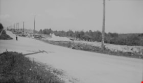
- Scope and Content
- Photograph of the Charles Street and Gilmore Avenue intersection with houses under construction on the right side of the street. This is part of the Willingdon Heights subdivision site.
- Media Type
- Photograph
- Photographer
- Bingham, Alfred "Alf"
- Notes
- Title based on contents of photograph
- Geographic Access
- Charles Street
- Gilmore Avenue
Images
Charles Street and Willingdon Avenue
https://search.heritageburnaby.ca/link/archivedescription34198
- Repository
- City of Burnaby Archives
- Date
- June 17, 1947
- Collection/Fonds
- Burnaby Historical Society fonds
- Description Level
- Item
- Physical Description
- 1 photograph : b&w negative ; 6.8 x 11.2 cm
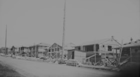
- Scope and Content
- Photograph of Charles Street and Willingdon Avenue with the road in the foreground and houses under construction in the background. This is part of the Willingdon Heights subdivision site.
- Repository
- City of Burnaby Archives
- Date
- June 17, 1947
- Collection/Fonds
- Burnaby Historical Society fonds
- Subseries
- Alfred Bingham subseries
- Physical Description
- 1 photograph : b&w negative ; 6.8 x 11.2 cm
- Description Level
- Item
- Record No.
- 010-114
- Access Restriction
- No restrictions
- Reproduction Restriction
- No known restrictions
- Accession Number
- BHS2007-04
- Scope and Content
- Photograph of Charles Street and Willingdon Avenue with the road in the foreground and houses under construction in the background. This is part of the Willingdon Heights subdivision site.
- Media Type
- Photograph
- Photographer
- Bingham, Alfred "Alf"
- Notes
- Title based on contents of photograph
- Geographic Access
- Charles Street
- Willingdon Avenue
Images
Children on Antrim Avenue
https://search.heritageburnaby.ca/link/archivedescription38012
- Repository
- City of Burnaby Archives
- Date
- [1940] (date of original), copied 1991
- Collection/Fonds
- Burnaby Historical Society fonds
- Description Level
- Item
- Physical Description
- 1 photograph : b&w ; 2.3 x 3.1 cm print on contact sheet 20.6 x 26.9 cm
- Scope and Content
- Photograph of two children in the front yard of 2224 Antrim Avenue (later renumbered 6957 Antrim Avenue).
- Repository
- City of Burnaby Archives
- Date
- [1940] (date of original), copied 1991
- Collection/Fonds
- Burnaby Historical Society fonds
- Subseries
- Burnaby Image Bank subseries
- Physical Description
- 1 photograph : b&w ; 2.3 x 3.1 cm print on contact sheet 20.6 x 26.9 cm
- Description Level
- Item
- Record No.
- 370-599
- Access Restriction
- No restrictions
- Reproduction Restriction
- No known restrictions
- Accession Number
- BHS1999-03
- Scope and Content
- Photograph of two children in the front yard of 2224 Antrim Avenue (later renumbered 6957 Antrim Avenue).
- Media Type
- Photograph
- Notes
- Title based on contents of photograph
- 1 b&w copy negative accompanying
- Negative has a pink cast
- Geographic Access
- Antrim Avenue
- Street Address
- 6957 Antrim Avenue
- Historic Neighbourhood
- Central Park (Historic Neighbourhood)
- Planning Study Area
- Windsor Area
Images
Diana Mumford at school crossing
https://search.heritageburnaby.ca/link/archivedescription97528
- Repository
- City of Burnaby Archives
- Date
- [2000]
- Collection/Fonds
- Burnaby NewsLeader photograph collection
- Description Level
- Item
- Physical Description
- 1 photograph (tiff) : col.
- Scope and Content
- Photograph of Diana Mumford standing on the shoulder of Rumble Street beside a school zone sign, in front of the Suncrest Elementary fences.
- Repository
- City of Burnaby Archives
- Date
- [2000]
- Collection/Fonds
- Burnaby NewsLeader photograph collection
- Physical Description
- 1 photograph (tiff) : col.
- Description Level
- Item
- Record No.
- 535-2867
- Access Restriction
- No restrictions
- Reproduction Restriction
- No restrictions
- Accession Number
- 2018-12
- Scope and Content
- Photograph of Diana Mumford standing on the shoulder of Rumble Street beside a school zone sign, in front of the Suncrest Elementary fences.
- Media Type
- Photograph
- Photographer
- Bartel, Mario
- Notes
- Title based on caption
- Collected by editorial for use in an October 2000 issue of the Burnaby NewsLeader
- Caption from metadata: "Diana Mumford is upset at the lack of sidewalks and safe bus stops along Rumble St. The north side of the street at Suncrest Elementary has speed zone signs, but no sidewalks along which children can safely walk to the school."
- Geographic Access
- Rumble Street
- Street Address
- 3883 Rumble Street
- Historic Neighbourhood
- Alta Vista (Historic Neighbourhood)
- Planning Study Area
- Suncrest Area
Images
Gilmore Avenue and Douglas Road
https://search.heritageburnaby.ca/link/archivedescription34164
- Repository
- City of Burnaby Archives
- Date
- May 1, 1947
- Collection/Fonds
- Burnaby Historical Society fonds
- Description Level
- Item
- Physical Description
- 1 photograph : b&w negative ; 6.8 x 11.8 cm
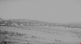
- Scope and Content
- Photograph of cleared land at Gilmore Avenue and Douglas Road. Houses under construction can be seen in the background. This is part of the Willingdon Heights subdivision site.
- Repository
- City of Burnaby Archives
- Date
- May 1, 1947
- Collection/Fonds
- Burnaby Historical Society fonds
- Subseries
- Alfred Bingham subseries
- Physical Description
- 1 photograph : b&w negative ; 6.8 x 11.8 cm
- Description Level
- Item
- Record No.
- 010-081
- Access Restriction
- No restrictions
- Reproduction Restriction
- No known restrictions
- Accession Number
- BHS2007-04
- Scope and Content
- Photograph of cleared land at Gilmore Avenue and Douglas Road. Houses under construction can be seen in the background. This is part of the Willingdon Heights subdivision site.
- Subjects
- Industries - Construction
- Buildings - Residential - Houses
- Land Clearing
- Geographic Features - Roads
- Media Type
- Photograph
- Photographer
- Bingham, Alfred "Alf"
- Notes
- Title based on contents of photograph
- Geographic Access
- Gilmore Avenue
- Douglas Road
Images
Gilmore Avenue and Douglas Road
https://search.heritageburnaby.ca/link/archivedescription34173
- Repository
- City of Burnaby Archives
- Date
- May 9, 1947
- Collection/Fonds
- Burnaby Historical Society fonds
- Description Level
- Item
- Physical Description
- 1 photograph : b&w negative ; 6.8 x 11.6 cm
- Scope and Content
- Photograph of the Gilmore Avenue and Douglas Road intersection with houses under construction on either side of the road, and a bicycle in foreground. This is part of the Willingdon Heights subdivision site.
- Repository
- City of Burnaby Archives
- Date
- May 9, 1947
- Collection/Fonds
- Burnaby Historical Society fonds
- Subseries
- Alfred Bingham subseries
- Physical Description
- 1 photograph : b&w negative ; 6.8 x 11.6 cm
- Description Level
- Item
- Record No.
- 010-090
- Access Restriction
- No restrictions
- Reproduction Restriction
- No known restrictions
- Accession Number
- BHS2007-04
- Scope and Content
- Photograph of the Gilmore Avenue and Douglas Road intersection with houses under construction on either side of the road, and a bicycle in foreground. This is part of the Willingdon Heights subdivision site.
- Subjects
- Transportation - Bicycles
- Industries - Construction
- Buildings - Residential - Houses
- Geographic Features - Roads
- Media Type
- Photograph
- Photographer
- Bingham, Alfred "Alf"
- Notes
- Title based on contents of photograph
- Geographic Access
- Gilmore Avenue
- Douglas Road
Images
Kitchener Street and Gilmore Avenue
https://search.heritageburnaby.ca/link/archivedescription34180
- Repository
- City of Burnaby Archives
- Date
- May 9, 1947
- Collection/Fonds
- Burnaby Historical Society fonds
- Description Level
- Item
- Physical Description
- 1 photograph : b&w negative ; 6.8 x 11.3 cm
- Scope and Content
- Photograph of Kitchener Street and Gilmore Avenue with houses under construction on the right side of the street. A man is standing on the roof of one of the houses. This is part of the Willingdon Heights subdivision site.
- Repository
- City of Burnaby Archives
- Date
- May 9, 1947
- Collection/Fonds
- Burnaby Historical Society fonds
- Subseries
- Alfred Bingham subseries
- Physical Description
- 1 photograph : b&w negative ; 6.8 x 11.3 cm
- Description Level
- Item
- Record No.
- 010-097
- Access Restriction
- No restrictions
- Reproduction Restriction
- No known restrictions
- Accession Number
- BHS2007-04
- Scope and Content
- Photograph of Kitchener Street and Gilmore Avenue with houses under construction on the right side of the street. A man is standing on the roof of one of the houses. This is part of the Willingdon Heights subdivision site.
- Subjects
- Occupations - Labourers
- Industries - Construction
- Buildings - Residential - Houses
- Geographic Features - Roads
- Media Type
- Photograph
- Photographer
- Bingham, Alfred "Alf"
- Notes
- Title based on contents of photograph
- Geographic Access
- Kitchener Street
- Gilmore Avenue
Images
Madison Avenue
https://search.heritageburnaby.ca/link/archivedescription34242
- Repository
- City of Burnaby Archives
- Date
- August 20, 1947
- Collection/Fonds
- Burnaby Historical Society fonds
- Description Level
- Item
- Physical Description
- 1 photograph : b&w negative ; 6.8 x 11.4 cm
- Scope and Content
- Photograph of Madison Avenue northeast icluding the road in the foreground and houses in the background. This is part of the Willingdon Heights subdivision site.
- Repository
- City of Burnaby Archives
- Date
- August 20, 1947
- Collection/Fonds
- Burnaby Historical Society fonds
- Subseries
- Alfred Bingham subseries
- Physical Description
- 1 photograph : b&w negative ; 6.8 x 11.4 cm
- Description Level
- Item
- Record No.
- 010-154
- Access Restriction
- No restrictions
- Reproduction Restriction
- No known restrictions
- Accession Number
- BHS2007-04
- Scope and Content
- Photograph of Madison Avenue northeast icluding the road in the foreground and houses in the background. This is part of the Willingdon Heights subdivision site.
- Media Type
- Photograph
- Photographer
- Bingham, Alfred "Alf"
- Notes
- Title based on contents of photograph
- Geographic Access
- Madison Avenue
![3700 block of Hastings Street, [2000] thumbnail](/media/hpo/_Data/_Archives_Images/_Unrestricted/535/535-3066.jpg?width=280)
![Wendy Jenkinson outside of the Swap Centre, [2000] thumbnail](/media/hpo/_Data/_Archives_Images/_Unrestricted/535/535-3108.jpg?width=280)
![Credit union employee, [2001] thumbnail](/media/hpo/_Data/_Archives_Images/_Unrestricted/535/535-1571.jpg?width=280)
![Emanuel Sandhu signing autographs, [2003] thumbnail](/media/hpo/_Data/_Archives_Images/_Unrestricted/535/535-2282-1.jpg?width=280)
![Banff, Alberta, [1944] thumbnail](/media/hpo/_Data/_BVM_Images/2000/200500300033.jpg?width=280)
![Dover Street crosswalk lights, [2000] thumbnail](/media/hpo/_Data/_Archives_Images/_Unrestricted/535/535-2540.jpg?width=280)
![Mickey McGuire and Jack Nichols, [between 1940 and 1944] (date of original), copied 1991 thumbnail](/media/hpo/_Data/_Archives_Images/_Unrestricted/370/370-736.jpg?width=280)
![Mickey McGuire and Jack Nichols, [between 1940 and 1944] (date of original), copied 1991 thumbnail](/media/hpo/_Data/_Archives_Images/_Unrestricted/370/370-737.jpg?width=280)
![6100 Block Kathleen Avenue, [1943 or 1944] (date of original), copied 1991 thumbnail](/media/hpo/_Data/_Archives_Images/_Unrestricted/370/370-241.jpg?width=280)
![Brantford Elementary school crosswalk, [2004] thumbnail](/media/hpo/_Data/_Archives_Images/_Unrestricted/535/535-2054.jpg?width=280)
![Children on Antrim Avenue, [1940] (date of original), copied 1991 thumbnail](/media/hpo/_Data/_Archives_Images/_Unrestricted/370/370-599.jpg?width=280)
![Diana Mumford at school crossing, [2000] thumbnail](/media/hpo/_Data/_Archives_Images/_Unrestricted/535/535-2867.jpg?width=280)
