More like 'Deer Crossing Sign on Road to SFU'
Narrow Results By
Subject
- Accidents - Automobile Accidents 4
- Advertising Medium - Signs and Signboards 3
- Aerial Photographs 4
- Agricultural Tools and Equipment - Plows 1
- Agriculture 3
- Agriculture - Crops 2
- Agriculture - Farms 5
- Agriculture - Fruit and Berries 1
- Animals - Bears 4
- Animals - Birds 4
- Animals - Cats 1
- Animals - Deer 1
![Rail crossing at Government and Cariboo, [2006] thumbnail](/media/hpo/_Data/_Archives_Images/_Unrestricted/535/535-1880.jpg?width=280)
Rail crossing at Government and Cariboo
https://search.heritageburnaby.ca/link/archivedescription96183
- Repository
- City of Burnaby Archives
- Date
- [2006]
- Collection/Fonds
- Burnaby NewsLeader photograph collection
- Description Level
- Item
- Physical Description
- 1 photograph (tiff) : b&w
- Scope and Content
- Photograph of the rail crossing at the intersection of Government Street and Cariboo Road. Two cars are passing on the road and the opposite directions of traffic are separated by a barrier on the road.
- Repository
- City of Burnaby Archives
- Date
- [2006]
- Collection/Fonds
- Burnaby NewsLeader photograph collection
- Physical Description
- 1 photograph (tiff) : b&w
- Description Level
- Item
- Record No.
- 535-1880
- Access Restriction
- No restrictions
- Reproduction Restriction
- No restrictions
- Accession Number
- 2018-12
- Scope and Content
- Photograph of the rail crossing at the intersection of Government Street and Cariboo Road. Two cars are passing on the road and the opposite directions of traffic are separated by a barrier on the road.
- Media Type
- Photograph
- Photographer
- Bartel, Mario
- Notes
- Title based on caption
- Collected by editorial for use in a January 2006 issue of the Burnaby NewsLeader
- Caption from metadata: "An accident involving a car and a train last summer has prompted the installation of barriers at the rail crossing at Government and Cariboo to prevent cars from jumping the line to beat the crossing arms."
- Geographic Access
- Government Street
- Cariboo Road
- Planning Study Area
- Burnaby Lake Area
Images
![Rail crossing at Government and Cariboo, [2006] thumbnail](/media/hpo/_Data/_Archives_Images/_Unrestricted/535/535-1880.jpg)
![Gaglardi Way pedestrian overpass, [2005] thumbnail](/media/hpo/_Data/_Archives_Images/_Unrestricted/535/535-1858.jpg?width=280)
Gaglardi Way pedestrian overpass
https://search.heritageburnaby.ca/link/archivedescription96161
- Repository
- City of Burnaby Archives
- Date
- [2005]
- Collection/Fonds
- Burnaby NewsLeader photograph collection
- Description Level
- Item
- Physical Description
- 1 photograph (tiff) : col.
- Scope and Content
- Photograph of Alex Nemeth posing next to his truck and the pedestrian overpass on Gaglardi Way.
- Repository
- City of Burnaby Archives
- Date
- [2005]
- Collection/Fonds
- Burnaby NewsLeader photograph collection
- Physical Description
- 1 photograph (tiff) : col.
- Description Level
- Item
- Record No.
- 535-1858
- Access Restriction
- No restrictions
- Reproduction Restriction
- No restrictions
- Accession Number
- 2018-12
- Scope and Content
- Photograph of Alex Nemeth posing next to his truck and the pedestrian overpass on Gaglardi Way.
- Media Type
- Photograph
- Photographer
- Bartel, Mario
- Notes
- Title based on caption
- Collected by editorial for use in a January 2005 issue of the Burnaby NewsLeader
- Caption from metadata: "The windshield on Alex Nemeth's pickup truck was smashed on Tuesday when kids dropped snowballs filled with rocks from the pedestrian overpass on Gagliardi Way in Burnaby as he passed underneath on his way to work. The City of Burnaby has promised to enclose the walkway."
- Geographic Access
- Gaglardi Way
Images
![Gaglardi Way pedestrian overpass, [2005] thumbnail](/media/hpo/_Data/_Archives_Images/_Unrestricted/535/535-1858.jpg)
![Willingdon on-ramp flooding, [2005] thumbnail](/media/hpo/_Data/_Archives_Images/_Unrestricted/535/535-1860-1.jpg?width=280)
Willingdon on-ramp flooding
https://search.heritageburnaby.ca/link/archivedescription96163
- Repository
- City of Burnaby Archives
- Date
- [2005]
- Collection/Fonds
- Burnaby NewsLeader photograph collection
- Description Level
- File
- Physical Description
- 2 photographs (tiff) : col.
- Scope and Content
- File contains photographs of flooding at the Willingdon on-ramp to Highway 1 in Burnaby after a significant rainstorm. Photographs depict a worker placing pylons to close the on-ramp and cars attempting to drive through deep puddles by the highway.
- Repository
- City of Burnaby Archives
- Date
- [2005]
- Collection/Fonds
- Burnaby NewsLeader photograph collection
- Physical Description
- 2 photographs (tiff) : col.
- Description Level
- File
- Record No.
- 535-1860
- Access Restriction
- No restrictions
- Reproduction Restriction
- No restrictions
- Accession Number
- 2018-12
- Scope and Content
- File contains photographs of flooding at the Willingdon on-ramp to Highway 1 in Burnaby after a significant rainstorm. Photographs depict a worker placing pylons to close the on-ramp and cars attempting to drive through deep puddles by the highway.
- Media Type
- Photograph
- Photographer
- Bartel, Mario
- Notes
- Title based on caption
- Collected by editorial for use in a January 2005 issue of the Burnaby NewsLeader
- Caption from metadata for 535-1860-1: "A worker for Mainroad Contracting closes the Willingdon on-ramp to Highway 1 because of flooding during Monday's torrential rainstorm."
- Caption from metadata for 535-1860-2: "After two weeks of snow and cold temperatures, Lower Mainland drivers find themselves in familiar territory, plowing through deep puddles on Willingdon, just north of Highway 1."
- Geographic Access
- Willingdon Avenue
- Planning Study Area
- West Central Valley Area
Images
![Willingdon on-ramp flooding, [2005] thumbnail](/media/hpo/_Data/_Archives_Images/_Unrestricted/535/535-1860-1.jpg)
![Bus and SkyTrain, [2000] thumbnail](/media/hpo/_Data/_Archives_Images/_Unrestricted/535/535-2549.jpg?width=280)
Bus and SkyTrain
https://search.heritageburnaby.ca/link/archivedescription97017
- Repository
- City of Burnaby Archives
- Date
- [2000]
- Collection/Fonds
- Burnaby NewsLeader photograph collection
- Description Level
- Item
- Physical Description
- 1 photograph (tiff) : b&w
- Scope and Content
- Photograph of a "Not in Service" electric bus and cars on an unidentified, tree-lined road. The SkyTrain is passing over the road.
- Repository
- City of Burnaby Archives
- Date
- [2000]
- Collection/Fonds
- Burnaby NewsLeader photograph collection
- Physical Description
- 1 photograph (tiff) : b&w
- Description Level
- Item
- Record No.
- 535-2549
- Access Restriction
- No restrictions
- Reproduction Restriction
- No restrictions
- Accession Number
- 2018-12
- Scope and Content
- Photograph of a "Not in Service" electric bus and cars on an unidentified, tree-lined road. The SkyTrain is passing over the road.
- Subjects
- Transportation - Skytrain
- Transportation - Buses
- Transportation - Public Transit
- Geographic Features - Roads
- Media Type
- Photograph
- Notes
- Title based on contents of photograph
- Collected by editorial for use in a July 2000 issue of the Burnaby NewsLeader
Images
![Bus and SkyTrain, [2000] thumbnail](/media/hpo/_Data/_Archives_Images/_Unrestricted/535/535-2549.jpg)
![10th Avenue connector construction, [2002] thumbnail](/media/hpo/_Data/_Archives_Images/_Unrestricted/535/535-1984.jpg?width=280)
10th Avenue connector construction
https://search.heritageburnaby.ca/link/archivedescription96301
- Repository
- City of Burnaby Archives
- Date
- [2002]
- Collection/Fonds
- Burnaby NewsLeader photograph collection
- Description Level
- Item
- Physical Description
- 1 photograph (tiff) : col.
- Scope and Content
- Photograph of the view of the new 10th Avenue connector from Gord Thorneycroft's garage. Thorneycroft holds a mug and is silhouetted by the light coming from outside, where the Bombardier SkyTrain plant is visible in the distance.
- Repository
- City of Burnaby Archives
- Date
- [2002]
- Collection/Fonds
- Burnaby NewsLeader photograph collection
- Physical Description
- 1 photograph (tiff) : col.
- Description Level
- Item
- Record No.
- 535-1984
- Access Restriction
- No restrictions
- Reproduction Restriction
- No restrictions
- Accession Number
- 2018-12
- Scope and Content
- Photograph of the view of the new 10th Avenue connector from Gord Thorneycroft's garage. Thorneycroft holds a mug and is silhouetted by the light coming from outside, where the Bombardier SkyTrain plant is visible in the distance.
- Media Type
- Photograph
- Photographer
- Bartel, Mario
- Notes
- Title based on caption
- Collected by editorial for use in a February 2002 issue of the Burnaby NewsLeader
- Caption from metadata: "Gord Thorneycroft says he used to be able to enjoy his morning coffee looking out onto a quiet, tree-lined lane while working in his garage behind his home on 9th Ave. But workers building the new 10th Ave. connector tore out the trees last September, the City of Burnaby isn't making any promises to erect noise barriers, and his lane has become a thoroughfare to the Bombardier Skytrain plant."
- Geographic Access
- 10th Avenue
- Historic Neighbourhood
- Edmonds (Historic Neighbourhood)
- Planning Study Area
- Stride Avenue Area
Images
![10th Avenue connector construction, [2002] thumbnail](/media/hpo/_Data/_Archives_Images/_Unrestricted/535/535-1984.jpg)
![Boundary Road and Hastings Street Intersection, [1943 or 1944] (date of original), copied 1991 thumbnail](/media/hpo/_Data/_Archives_Images/_Unrestricted/370/370-229.jpg?width=280)
Boundary Road and Hastings Street Intersection
https://search.heritageburnaby.ca/link/archivedescription37641
- Repository
- City of Burnaby Archives
- Date
- [1943 or 1944] (date of original), copied 1991
- Collection/Fonds
- Burnaby Historical Society fonds
- Description Level
- Item
- Physical Description
- 1 photograph : b&w ; 3.2 x 5.3 cm print on contact sheet 20.2 x 25.3 cm
- Scope and Content
- Photograph of the intersection of Boundary Road and Hastings Street facing east from the southwest corner. A streetcar has a sign advertising Victory Bonds.
- Repository
- City of Burnaby Archives
- Date
- [1943 or 1944] (date of original), copied 1991
- Collection/Fonds
- Burnaby Historical Society fonds
- Subseries
- Burnaby Image Bank subseries
- Physical Description
- 1 photograph : b&w ; 3.2 x 5.3 cm print on contact sheet 20.2 x 25.3 cm
- Description Level
- Item
- Record No.
- 370-229
- Access Restriction
- No restrictions
- Reproduction Restriction
- No known restrictions
- Accession Number
- BHS1999-03
- Scope and Content
- Photograph of the intersection of Boundary Road and Hastings Street facing east from the southwest corner. A streetcar has a sign advertising Victory Bonds.
- Media Type
- Photograph
- Notes
- Title based on contents of photograph
- 1 b&w copy negative accompanying
- Geographic Access
- Boundary Road
- Hastings Street
- Historic Neighbourhood
- Vancouver Heights (Historic Neighbourhood)
- Planning Study Area
- Burnaby Heights Area
- Willingdon Heights Area
Images
![Boundary Road and Hastings Street Intersection, [1943 or 1944] (date of original), copied 1991 thumbnail](/media/hpo/_Data/_Archives_Images/_Unrestricted/370/370-229.jpg)

Gilmore Avenue and Douglas Road
https://search.heritageburnaby.ca/link/archivedescription34173
- Repository
- City of Burnaby Archives
- Date
- May 9, 1947
- Collection/Fonds
- Burnaby Historical Society fonds
- Description Level
- Item
- Physical Description
- 1 photograph : b&w negative ; 6.8 x 11.6 cm
- Scope and Content
- Photograph of the Gilmore Avenue and Douglas Road intersection with houses under construction on either side of the road, and a bicycle in foreground. This is part of the Willingdon Heights subdivision site.
- Repository
- City of Burnaby Archives
- Date
- May 9, 1947
- Collection/Fonds
- Burnaby Historical Society fonds
- Subseries
- Alfred Bingham subseries
- Physical Description
- 1 photograph : b&w negative ; 6.8 x 11.6 cm
- Description Level
- Item
- Record No.
- 010-090
- Access Restriction
- No restrictions
- Reproduction Restriction
- No known restrictions
- Accession Number
- BHS2007-04
- Scope and Content
- Photograph of the Gilmore Avenue and Douglas Road intersection with houses under construction on either side of the road, and a bicycle in foreground. This is part of the Willingdon Heights subdivision site.
- Subjects
- Transportation - Bicycles
- Industries - Construction
- Buildings - Residential - Houses
- Geographic Features - Roads
- Media Type
- Photograph
- Photographer
- Bingham, Alfred "Alf"
- Notes
- Title based on contents of photograph
- Geographic Access
- Gilmore Avenue
- Douglas Road
Images

Lorne Auvache
https://search.heritageburnaby.ca/link/archivedescription37503
- Repository
- City of Burnaby Archives
- Date
- December 1940 (date of original), copied 1991
- Collection/Fonds
- Burnaby Historical Society fonds
- Description Level
- Item
- Physical Description
- 1 photograph : b&w ; 3.2 x 5.0 cm print on contact sheet 20.3 x 25.3 cm
- Scope and Content
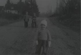
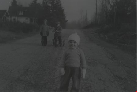
- Photograph of Lorne Auvache wearing a hat and mittens on the 7200 block of Arcola Street. A young boy is on a tricycle, and another young boy is standing beside him in the background.
- Repository
- City of Burnaby Archives
- Date
- December 1940 (date of original), copied 1991
- Collection/Fonds
- Burnaby Historical Society fonds
- Subseries
- Burnaby Image Bank subseries
- Physical Description
- 1 photograph : b&w ; 3.2 x 5.0 cm print on contact sheet 20.3 x 25.3 cm
- Description Level
- Item
- Record No.
- 370-091
- Access Restriction
- No restrictions
- Reproduction Restriction
- No known restrictions
- Accession Number
- BHS1999-03
- Scope and Content
- Photograph of Lorne Auvache wearing a hat and mittens on the 7200 block of Arcola Street. A young boy is on a tricycle, and another young boy is standing beside him in the background.
- Names
- Auvache, Lorne
- Media Type
- Photograph
- Notes
- Title based on contents of photograph
- Piece missing from photograph on contact sheet
- 1 b&w copy negative accompanying
- Geographic Access
- Arcola Street
- Historic Neighbourhood
- Edmonds (Historic Neighbourhood)
- Planning Study Area
- Richmond Park Area
Images
![Lyle Le Grove with a baby carriage, [1943] (date of original), copied 1991 thumbnail](/media/hpo/_Data/_Archives_Images/_Unrestricted/370/370-618.jpg?width=280)
Lyle Le Grove with a baby carriage
https://search.heritageburnaby.ca/link/archivedescription38031
- Repository
- City of Burnaby Archives
- Date
- [1943] (date of original), copied 1991
- Collection/Fonds
- Burnaby Historical Society fonds
- Description Level
- Item
- Physical Description
- 1 photograph : b&w ; 3.6 x 2.7 cm print on contact sheet 20.6 x 26.3 cm
- Scope and Content
- Photograph Lyle Le Grove with a baby carriage, at 2224 Antrim Avenue (later renumbered as 6957 Antrim Avenue).
- Repository
- City of Burnaby Archives
- Date
- [1943] (date of original), copied 1991
- Collection/Fonds
- Burnaby Historical Society fonds
- Subseries
- Burnaby Image Bank subseries
- Physical Description
- 1 photograph : b&w ; 3.6 x 2.7 cm print on contact sheet 20.6 x 26.3 cm
- Description Level
- Item
- Record No.
- 370-618
- Access Restriction
- No restrictions
- Reproduction Restriction
- No known restrictions
- Accession Number
- BHS1999-03
- Scope and Content
- Photograph Lyle Le Grove with a baby carriage, at 2224 Antrim Avenue (later renumbered as 6957 Antrim Avenue).
- Media Type
- Photograph
- Notes
- Title based on contents of photograph
- 1 b&w copy negative accompanying
- Negative has a pink cast
- Geographic Access
- Antrim Avenue
- Street Address
- 6957 Antrim Avenue
- Historic Neighbourhood
- Central Park (Historic Neighbourhood)
- Planning Study Area
- Windsor Area
Images
![Lyle Le Grove with a baby carriage, [1943] (date of original), copied 1991 thumbnail](/media/hpo/_Data/_Archives_Images/_Unrestricted/370/370-618.jpg)

Rayside Drive and Canada Way
https://search.heritageburnaby.ca/link/archivedescription39753
- Repository
- City of Burnaby Archives
- Date
- 2002
- Collection/Fonds
- Burnaby Historical Society fonds
- Description Level
- Item
- Physical Description
- 1 photograph : col.; 10 x 15 cm
- Scope and Content
- Photograph of vehicle traffic along Canada Way just past the Rayside Drive intersection.
- Repository
- City of Burnaby Archives
- Date
- 2002
- Collection/Fonds
- Burnaby Historical Society fonds
- Subseries
- Photographs subseries
- Physical Description
- 1 photograph : col.; 10 x 15 cm
- Description Level
- Item
- Record No.
- 442-002
- Access Restriction
- No restrictions
- Reproduction Restriction
- Reproduce for fair dealing purposes only
- Accession Number
- BHS2007-04
- Scope and Content
- Photograph of vehicle traffic along Canada Way just past the Rayside Drive intersection.
- Media Type
- Photograph
- Notes
- Title based on contents of photograph.
- Geographic Access
- Canada Way
- Rayside Street
- Historic Neighbourhood
- Burnaby Lake (Historic Neighbourhood)
- Planning Study Area
- Morley-Buckingham Area
Images

![Sledding down the street, [194-?] (date of original), copied 1976 thumbnail](/media/hpo/_Data/_BVM_Images/1974/197602510020.jpg?width=280)
Sledding down the street
https://search.heritageburnaby.ca/link/museumdescription1615
- Repository
- Burnaby Village Museum
- Date
- [194-?] (date of original), copied 1976
- Collection/Fonds
- Burnaby Village Museum Photograph collection
- Description Level
- Item
- Physical Description
- 1 photograph : b&w negative ; 5.6 x 8.2 cm
- Scope and Content
- Photograph of a snow covered street, with a woman standing behind two children on a sled. The street is lined with electric power poles, and there is a parked car on the left of the photograph and houses on the right. The people and location are unidentified, but it is possible that the photograph …
- Repository
- Burnaby Village Museum
- Collection/Fonds
- Burnaby Village Museum Photograph collection
- Description Level
- Item
- Physical Description
- 1 photograph : b&w negative ; 5.6 x 8.2 cm
- Scope and Content
- Photograph of a snow covered street, with a woman standing behind two children on a sled. The street is lined with electric power poles, and there is a parked car on the left of the photograph and houses on the right. The people and location are unidentified, but it is possible that the photograph was taken in Burnaby.
- Accession Code
- HV976.251.20
- Access Restriction
- No restrictions
- Reproduction Restriction
- May be restricted by third party rights
- Date
- [194-?] (date of original), copied 1976
- Media Type
- Photograph
- Scan Resolution
- 300
- Scan Date
- 22/8/2006
- Scale
- 100
- Notes
- Title based on contents of photograph
Images
![Sledding down the street, [194-?] (date of original), copied 1976 thumbnail](/media/hpo/_Data/_BVM_Images/1974/197602510020.jpg)
Three young women on bicycles
https://search.heritageburnaby.ca/link/archivedescription53960
- Repository
- City of Burnaby Archives
- Date
- 1942
- Collection/Fonds
- Burnaby Historical Society fonds
- Description Level
- Item
- Physical Description
- 1 photograph : b&w copy negative ; 35 mm
- Scope and Content
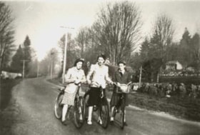
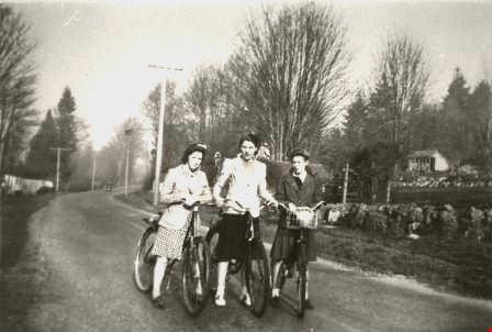
- Photograph of three young women in skirts, stopping on their bicycles in the center of a winding road.
- Repository
- City of Burnaby Archives
- Date
- 1942
- Collection/Fonds
- Burnaby Historical Society fonds
- Subseries
- Kay North subseries
- Physical Description
- 1 photograph : b&w copy negative ; 35 mm
- Description Level
- Item
- Record No.
- 269-007
- Access Restriction
- No restrictions
- Reproduction Restriction
- No known restrictions
- Accession Number
- BHS1991-38
- Scope and Content
- Photograph of three young women in skirts, stopping on their bicycles in the center of a winding road.
- Media Type
- Photograph
- Notes
- Title based on contents of photograph
Images
![North Burnaby neighbourhood traffic, [2002] thumbnail](/media/hpo/_Data/_Archives_Images/_Unrestricted/535/535-2834.jpg?width=280)
North Burnaby neighbourhood traffic
https://search.heritageburnaby.ca/link/archivedescription97495
- Repository
- City of Burnaby Archives
- Date
- [2002]
- Collection/Fonds
- Burnaby NewsLeader photograph collection
- Description Level
- Item
- Physical Description
- 1 photograph (tiff) : col.
- Scope and Content
- Photograph of Glen Webb and Megan Perry standing on a residential street in their North Burnaby neighbourhood. A car is driving up the hill, and the Vancouver skyline is visible in the distance.
- Repository
- City of Burnaby Archives
- Date
- [2002]
- Collection/Fonds
- Burnaby NewsLeader photograph collection
- Physical Description
- 1 photograph (tiff) : col.
- Description Level
- Item
- Record No.
- 535-2834
- Access Restriction
- No restrictions
- Reproduction Restriction
- No restrictions
- Accession Number
- 2018-12
- Scope and Content
- Photograph of Glen Webb and Megan Perry standing on a residential street in their North Burnaby neighbourhood. A car is driving up the hill, and the Vancouver skyline is visible in the distance.
- Media Type
- Photograph
- Photographer
- Bartel, Mario
- Notes
- Title based on caption
- Collected by editorial for use in an October 2002 issue of the Burnaby NewsLeader
- Caption from metadata: "Glen Webb and Megan Perry say their neighborhood in North Burnaby is fed up with commuters cutting along their residential streets as they try to avoid rush hour congestion along Hastings St."
- Historic Neighbourhood
- Capitol Hill (Historic Neighbourhood)
- Planning Study Area
- Capitol Hill Area
Images
![North Burnaby neighbourhood traffic, [2002] thumbnail](/media/hpo/_Data/_Archives_Images/_Unrestricted/535/535-2834.jpg)
![Traffic in Lakeview-Edmonds, [2001] thumbnail](/media/hpo/_Data/_Archives_Images/_Unrestricted/535/535-2959-1.jpg?width=280)
Traffic in Lakeview-Edmonds
https://search.heritageburnaby.ca/link/archivedescription97676
- Repository
- City of Burnaby Archives
- Date
- [2001]
- Collection/Fonds
- Burnaby NewsLeader photograph collection
- Description Level
- File
- Physical Description
- 4 photographs (tiff) : col.
- Scope and Content
- File contains photographs related to transportation and traffic in the Edmonds area of Burnaby. Photographs depict Argus Carriers delivery driver Terry Doyle at work in his delivery truck, and Lidia Rossi, Porcellato, and Muriel Logan, all members of the Lakeview-Edmonds Neighbourhood Association, …
- Repository
- City of Burnaby Archives
- Date
- [2001]
- Collection/Fonds
- Burnaby NewsLeader photograph collection
- Physical Description
- 4 photographs (tiff) : col.
- Description Level
- File
- Record No.
- 535-2959
- Access Restriction
- No restrictions
- Reproduction Restriction
- No restrictions
- Accession Number
- 2018-12
- Scope and Content
- File contains photographs related to transportation and traffic in the Edmonds area of Burnaby. Photographs depict Argus Carriers delivery driver Terry Doyle at work in his delivery truck, and Lidia Rossi, Porcellato, and Muriel Logan, all members of the Lakeview-Edmonds Neighbourhood Association, posing on a road and interacting with traffic at the corner of 6th and Edmonds.
- Media Type
- Photograph
- Photographer
- Bartel, Mario
- Notes
- Title based on caption
- Collected by editorial for use in a November 2001 issue of the Burnaby NewsLeader
- Caption from metadata for 535-2959-1: "Terry Doyle, a delivery driver for Argus Carriers, heads out to the busy streets of the Lower Mainland to deliver packages."
- Caption from metadata for 535-2959-2: "Terry Doyle, a delivery driver for Argus Carriers, says he tries not to bring the stresses of driving around the Lower Mainland home with him."
- Caption from metadata for 535-2959-3: "Lidia Rossi, Sophia Porcellato, and Muriel Logan have formed the Lakeview-Edmonds Neighbourhood Association to discuss ways to keep rat-running traffic out of their neighbourhood."
- Caption from metadata for 535-2959-4: "Lidia Rossi, of the Lakeview-Edmonds Neighborhood Association, motions to a rat-running motorist, at the corner of 6th St. and Edmonds, to stay out of the residential streets."
- Geographic Access
- 6th Street
- Edmonds Street
- Historic Neighbourhood
- Edmonds (Historic Neighbourhood)
- Planning Study Area
- Lakeview-Mayfield Area
Images
![Traffic in Lakeview-Edmonds, [2001] thumbnail](/media/hpo/_Data/_Archives_Images/_Unrestricted/535/535-2959-1.jpg)
![Banff, Alberta, [1944] thumbnail](/media/hpo/_Data/_BVM_Images/2000/200500300033.jpg?width=280)
Banff, Alberta
https://search.heritageburnaby.ca/link/museumdescription3411
- Repository
- Burnaby Village Museum
- Date
- [1944]
- Collection/Fonds
- Burnaby Village Museum Photograph collection
- Description Level
- Item
- Physical Description
- 1 photograph : b&w ; 10 x 6 cm
- Scope and Content
- Photograph of Mount Lougheed, taken looking north, from the main street in Banff.
- Repository
- Burnaby Village Museum
- Collection/Fonds
- Burnaby Village Museum Photograph collection
- Description Level
- Item
- Physical Description
- 1 photograph : b&w ; 10 x 6 cm
- Scope and Content
- Photograph of Mount Lougheed, taken looking north, from the main street in Banff.
- Accession Code
- BV005.30.33
- Access Restriction
- No restrictions
- Date
- [1944]
- Media Type
- Photograph
- Scan Date
- 1/19/2010
- Photographer
- Battersby, Frank
- Notes
- Title based on contents of photograph
Images
![Banff, Alberta, [1944] thumbnail](/media/hpo/_Data/_BVM_Images/2000/200500300033.jpg)
![Dover Street crosswalk lights, [2000] thumbnail](/media/hpo/_Data/_Archives_Images/_Unrestricted/535/535-2540.jpg?width=280)
Dover Street crosswalk lights
https://search.heritageburnaby.ca/link/archivedescription97008
- Repository
- City of Burnaby Archives
- Date
- [2000]
- Collection/Fonds
- Burnaby NewsLeader photograph collection
- Description Level
- Item
- Physical Description
- 1 photograph (tiff) : col.
- Scope and Content
- Photograph of the assistant director of traffic engineering at the City of Burnaby examining a piece of equipment installed in Dover Street as part of a pilot project for new crosswalk lights. A school crosswalk sign and passing vehicle are visible in the background.
- Repository
- City of Burnaby Archives
- Date
- [2000]
- Collection/Fonds
- Burnaby NewsLeader photograph collection
- Physical Description
- 1 photograph (tiff) : col.
- Description Level
- Item
- Record No.
- 535-2540
- Access Restriction
- No restrictions
- Reproduction Restriction
- No restrictions
- Accession Number
- 2018-12
- Scope and Content
- Photograph of the assistant director of traffic engineering at the City of Burnaby examining a piece of equipment installed in Dover Street as part of a pilot project for new crosswalk lights. A school crosswalk sign and passing vehicle are visible in the background.
- Subjects
- Geographic Features - Roads
- Geographic Features - Sidewalks
- Occupations - Civic Workers
- Public Services - Public Works
- Media Type
- Photograph
- Photographer
- Bartel, Mario
- Notes
- Title based on caption
- Collected by editorial for use in a July 2000 issue of the Burnaby NewsLeader
- Caption from metadata: "Burnaby's assistand director of traffic engineering examines the new crosswalk lights, installed as a pilot project, on Dover, between Royal Oak and Nelson."
- Geographic Access
- Dover Street
- Nelson Avenue
- Royal Oak Avenue
- Historic Neighbourhood
- Central Park (Historic Neighbourhood)
- Planning Study Area
- Marlborough Area
Images
![Dover Street crosswalk lights, [2000] thumbnail](/media/hpo/_Data/_Archives_Images/_Unrestricted/535/535-2540.jpg)
![Mickey McGuire and Jack Nichols, [between 1940 and 1944] (date of original), copied 1991 thumbnail](/media/hpo/_Data/_Archives_Images/_Unrestricted/370/370-736.jpg?width=280)
Mickey McGuire and Jack Nichols
https://search.heritageburnaby.ca/link/archivedescription38149
- Repository
- City of Burnaby Archives
- Date
- [between 1940 and 1944] (date of original), copied 1991
- Collection/Fonds
- Burnaby Historical Society fonds
- Description Level
- Item
- Physical Description
- 1 photograph : b&w ; 2.6 x 4.2 cm print on contact sheet 20.6 x 26.8 cm
- Scope and Content
- Photograph of Mickey McGuire (back) and Jack Nichols (front) on the 4000 block Kingsway (later renumbered the 4500 block) at McKay Avenue.
- Repository
- City of Burnaby Archives
- Date
- [between 1940 and 1944] (date of original), copied 1991
- Collection/Fonds
- Burnaby Historical Society fonds
- Subseries
- Burnaby Image Bank subseries
- Physical Description
- 1 photograph : b&w ; 2.6 x 4.2 cm print on contact sheet 20.6 x 26.8 cm
- Description Level
- Item
- Record No.
- 370-736
- Access Restriction
- No restrictions
- Reproduction Restriction
- No restrictions
- Accession Number
- BHS1999-03
- Scope and Content
- Photograph of Mickey McGuire (back) and Jack Nichols (front) on the 4000 block Kingsway (later renumbered the 4500 block) at McKay Avenue.
- Names
- McGuire, Mickey
- Nichols, Jack
- Media Type
- Photograph
- Notes
- Title based on contents of photograph
- 1 b&w copy negative accompanying
- Negative has a pink cast
- Geographic Access
- Kingsway
- Historic Neighbourhood
- Central Park (Historic Neighbourhood)
- Planning Study Area
- Maywood Area
- Marlborough Area
Images
![Mickey McGuire and Jack Nichols, [between 1940 and 1944] (date of original), copied 1991 thumbnail](/media/hpo/_Data/_Archives_Images/_Unrestricted/370/370-736.jpg)
![Mickey McGuire and Jack Nichols, [between 1940 and 1944] (date of original), copied 1991 thumbnail](/media/hpo/_Data/_Archives_Images/_Unrestricted/370/370-737.jpg?width=280)
Mickey McGuire and Jack Nichols
https://search.heritageburnaby.ca/link/archivedescription38150
- Repository
- City of Burnaby Archives
- Date
- [between 1940 and 1944] (date of original), copied 1991
- Collection/Fonds
- Burnaby Historical Society fonds
- Description Level
- Item
- Physical Description
- 1 photograph : b&w ; 4.1 x 2.6 cm print on contact sheet 20.6 x 26.8 cm
- Scope and Content
- Photograph of Mickey McGuire (back) and Jack Nichols (front) on the 4000 block Kingsway (later renumbered the 4500 block) at McKay Avenue.
- Repository
- City of Burnaby Archives
- Date
- [between 1940 and 1944] (date of original), copied 1991
- Collection/Fonds
- Burnaby Historical Society fonds
- Subseries
- Burnaby Image Bank subseries
- Physical Description
- 1 photograph : b&w ; 4.1 x 2.6 cm print on contact sheet 20.6 x 26.8 cm
- Description Level
- Item
- Record No.
- 370-737
- Access Restriction
- No restrictions
- Reproduction Restriction
- No restrictions
- Accession Number
- BHS1999-03
- Scope and Content
- Photograph of Mickey McGuire (back) and Jack Nichols (front) on the 4000 block Kingsway (later renumbered the 4500 block) at McKay Avenue.
- Names
- McGuire, Mickey
- Nichols, Jack
- Media Type
- Photograph
- Notes
- Title based on contents of photograph
- 1 b&w copy negative accompanying
- Negative has a pink cast
- Caption at bottom of photograph reads, "Mickey McGuire and Jack Nichols"
- Geographic Access
- Kingsway
- Historic Neighbourhood
- Central Park (Historic Neighbourhood)
- Planning Study Area
- Maywood Area
- Marlborough Area
Images
![Mickey McGuire and Jack Nichols, [between 1940 and 1944] (date of original), copied 1991 thumbnail](/media/hpo/_Data/_Archives_Images/_Unrestricted/370/370-737.jpg)
![3700 block of Hastings Street, [2000] thumbnail](/media/hpo/_Data/_Archives_Images/_Unrestricted/535/535-3066.jpg?width=280)
3700 block of Hastings Street
https://search.heritageburnaby.ca/link/archivedescription97940
- Repository
- City of Burnaby Archives
- Date
- [2000]
- Collection/Fonds
- Burnaby NewsLeader photograph collection
- Description Level
- Item
- Physical Description
- 1 photograph (tiff) : b&w
- Scope and Content
- Photograph of the 3700 block of Hastings Street in North Burnaby, looking southeast. Kato Japanese Chinese Restaurant is one of the visible businesses and some snow is on the ground.
- Repository
- City of Burnaby Archives
- Date
- [2000]
- Collection/Fonds
- Burnaby NewsLeader photograph collection
- Physical Description
- 1 photograph (tiff) : b&w
- Description Level
- Item
- Record No.
- 535-3066
- Access Restriction
- No restrictions
- Reproduction Restriction
- No restrictions
- Accession Number
- 2018-12
- Scope and Content
- Photograph of the 3700 block of Hastings Street in North Burnaby, looking southeast. Kato Japanese Chinese Restaurant is one of the visible businesses and some snow is on the ground.
- Subjects
- Geographic Features - Roads
- Buildings - Commercial
- Buildings - Commercial - Restaurants
- Buildings - Residential
- Media Type
- Photograph
- Notes
- Title based on contents of photograph
- Collected by editorial for use in a January 2000 issue of the Burnaby NewsLeader
- Geographic Access
- Hastings Street
- Street Address
- 3700 Hastings Street
- Historic Neighbourhood
- Vancouver Heights (Historic Neighbourhood)
- Planning Study Area
- Burnaby Heights Area
Images
![3700 block of Hastings Street, [2000] thumbnail](/media/hpo/_Data/_Archives_Images/_Unrestricted/535/535-3066.jpg)
![4200 Block Cambridge Street, [1940] (date of original), copied 1991 thumbnail](/media/hpo/_Data/_Archives_Images/_Unrestricted/370/370-408.jpg?width=280)
4200 Block Cambridge Street
https://search.heritageburnaby.ca/link/archivedescription37820
- Repository
- City of Burnaby Archives
- Date
- [1940] (date of original), copied 1991
- Collection/Fonds
- Burnaby Historical Society fonds
- Description Level
- Item
- Physical Description
- 1 photograph : b&w ; 3.9 x 2.6 cm print on contact sheet 20.3 x 26.4 cm
- Scope and Content
- Photograph of a dog on the sidewalk of the 4200 block of Cambridge Street. The photograph was taken facing east, and Capitol Hill is visible in the background.
- Repository
- City of Burnaby Archives
- Date
- [1940] (date of original), copied 1991
- Collection/Fonds
- Burnaby Historical Society fonds
- Subseries
- Burnaby Image Bank subseries
- Physical Description
- 1 photograph : b&w ; 3.9 x 2.6 cm print on contact sheet 20.3 x 26.4 cm
- Description Level
- Item
- Record No.
- 370-408
- Access Restriction
- No restrictions
- Reproduction Restriction
- No known restrictions
- Accession Number
- BHS1999-03
- Scope and Content
- Photograph of a dog on the sidewalk of the 4200 block of Cambridge Street. The photograph was taken facing east, and Capitol Hill is visible in the background.
- Media Type
- Photograph
- Notes
- Title based on contents of photograph
- 1 b&w copy negative accompanying
- Negative has a pink cast
- Geographic Access
- Cambridge Street
- Historic Neighbourhood
- Vancouver Heights (Historic Neighbourhood)
- Planning Study Area
- Burnaby Heights Area
Images
![4200 Block Cambridge Street, [1940] (date of original), copied 1991 thumbnail](/media/hpo/_Data/_Archives_Images/_Unrestricted/370/370-408.jpg)