Narrow Results By
Subject
- Buildings - Civic - Hospitals 2
- Buildings - Commercial - Train Stations 1
- Buildings - Heritage 4
- Buildings - Residential - Houses 2
- Buildings - Schools 1
- Clothing - Uniforms 2
- Geographic Features - Mountains 1
- Geographic Features - Rivers 1
- Natural Phenomena - Snow 4
- Occupations - Nurses 2
- Plants - Flowers 1
- Plants - Trees 2
Person / Organization
- Armstrong Avenue School 2
- Barnes, Hannah Victoria "Girlie" Love 1
- British Columbia Electric Railway Company 1
- George Derby Health Centre 4
- Hunter, Beatrice "Bea" Carpenter 2
- Love, John Leonard 1
- Parker, Sarah Maria Love 5
- Parker, William "Bill" Charles 4
- Parker, William Michael 3
- Rudolph, Elmer 1
- Stanley, Esther Love 1

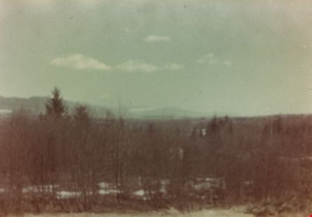
Taken from Armstrong Avenue School
https://search.heritageburnaby.ca/link/archivedescription35044
- Repository
- City of Burnaby Archives
- Date
- 1949 (date of original), copied 1986
- Collection/Fonds
- Burnaby Historical Society fonds
- Description Level
- Item
- Physical Description
- 1 photograph : col. ; 8.8 x 12.5 cm print
- Scope and Content
- Photograph taken from an Armstrong Avenue School classroom. An annotation on the back of the photograph reads, "View from the second floor of Armstrong Ave School looking North to Burnaby Lake, 1949."
- Repository
- City of Burnaby Archives
- Date
- 1949 (date of original), copied 1986
- Collection/Fonds
- Burnaby Historical Society fonds
- Subseries
- Chamberlain family subseries
- Physical Description
- 1 photograph : col. ; 8.8 x 12.5 cm print
- Description Level
- Item
- Record No.
- 179-015
- Access Restriction
- No restrictions
- Reproduction Restriction
- Reproduce for fair dealing purposes only
- Accession Number
- BHS1986-27
- Scope and Content
- Photograph taken from an Armstrong Avenue School classroom. An annotation on the back of the photograph reads, "View from the second floor of Armstrong Ave School looking North to Burnaby Lake, 1949."
- Subjects
- Plants - Trees
- Names
- Armstrong Avenue School
- Media Type
- Photograph
- Notes
- Title based on contents of photograph
- Print made from col. slide
- Geographic Access
- Armstrong Avenue
- Street Address
- 8757 Armstrong Avenue
- Historic Neighbourhood
- East Burnaby (Historic Neighbourhood)
- Planning Study Area
- Cariboo-Armstrong Area
Images
![Tram Station at Cumberland Road, [194-] thumbnail](/media/hpo/_Data/_BVM_Images/1977/197900390001.jpg?width=280)
Tram Station at Cumberland Road
https://search.heritageburnaby.ca/link/museumdescription441
- Repository
- Burnaby Village Museum
- Date
- [194-]
- Collection/Fonds
- Burnaby Village Museum Photograph collection
- Description Level
- Item
- Physical Description
- 1 photograph : b&w ; 9.0 x 6.3 cm
- Scope and Content
- Photograph of a woman sitting on the rail of a wooden walkway into a building. On the side of the building is painted a sign: "Cumberland / Road." Also visible on the wood plank wall is graffiti of a name: "John Mealings." An annotation on the back of the photo reads: "Eileen Bobergs' friend mid …
- Repository
- Burnaby Village Museum
- Collection/Fonds
- Burnaby Village Museum Photograph collection
- Description Level
- Item
- Physical Description
- 1 photograph : b&w ; 9.0 x 6.3 cm
- Scope and Content
- Photograph of a woman sitting on the rail of a wooden walkway into a building. On the side of the building is painted a sign: "Cumberland / Road." Also visible on the wood plank wall is graffiti of a name: "John Mealings." An annotation on the back of the photo reads: "Eileen Bobergs' friend mid 1940's / Burnaby Lake Tram Station." Stamped on the back of the photo: "205."
- Geographic Access
- Cumberland Street
- Burnaby Lake Interurban line
- Accession Code
- HV979.39.1
- Access Restriction
- No restrictions
- Reproduction Restriction
- May be restricted by third party rights
- Date
- [194-]
- Media Type
- Photograph
- Historic Neighbourhood
- East Burnaby (Historic Neighbourhood)
- Planning Study Area
- Cariboo-Armstrong Area
- Scan Resolution
- 600
- Scan Date
- 2023-09-12
- Notes
- Title based on contents of photograph
Images
![Tram Station at Cumberland Road, [194-] thumbnail](/media/hpo/_Data/_BVM_Images/1977/197900390001.jpg)
![William Parker with shovel, [between 1930 and 1940] (date of original), copied 1998 thumbnail](/media/hpo/_Data/_BVM_Images/2018/2018_0041_0169_001.jpg?width=280)
William Parker with shovel
https://search.heritageburnaby.ca/link/museumdescription9983
- Repository
- Burnaby Village Museum
- Date
- [between 1930 and 1940] (date of original), copied 1998
- Collection/Fonds
- Burnaby Village Museum fonds
- Description Level
- Item
- Physical Description
- 1 photograph : sepia print ; 13 x 9.5 cm
- Scope and Content
- Photograph of William Parker digging with a shovel on the grounds of the Love farmhouse. There is a barn and tree behind him. In 1928 after Sarah Parker's father, Jesse Love died, William and Sarah (nee Love) Parker purchased the Love farmhouse located at 1390 Cumberland Road. They lived there unt…
- Repository
- Burnaby Village Museum
- Collection/Fonds
- Burnaby Village Museum fonds
- Series
- Jesse Love farmhouse series
- Subseries
- Love family photographs subseries
- Description Level
- Item
- Physical Description
- 1 photograph : sepia print ; 13 x 9.5 cm
- Scope and Content
- Photograph of William Parker digging with a shovel on the grounds of the Love farmhouse. There is a barn and tree behind him. In 1928 after Sarah Parker's father, Jesse Love died, William and Sarah (nee Love) Parker purchased the Love farmhouse located at 1390 Cumberland Road. They lived there until 1961, with their three children; Albert, Bill and Elsie.
- Subjects
- Buildings - Heritage
- Geographic Access
- Cumberland Street
- Street Address
- 7651 Cumberland Street
- Accession Code
- BV018.41.169
- Access Restriction
- No restrictions
- Reproduction Restriction
- May be restricted by third party rights
- Date
- [between 1930 and 1940] (date of original), copied 1998
- Media Type
- Photograph
- Historic Neighbourhood
- East Burnaby (Historic Neighbourhood)
- Planning Study Area
- Cariboo-Armstrong Area
- Scan Resolution
- 600
- Scan Date
- 25-Feb-2019
- Scale
- 100
- Notes
- Title based on contents of photograph
- Photograph was copied from the Albert Parker photograph album in 1998
Images
![William Parker with shovel, [between 1930 and 1940] (date of original), copied 1998 thumbnail](/media/hpo/_Data/_BVM_Images/2018/2018_0041_0169_001.jpg)
![William Parker with shovel, [194-] thumbnail](/media/hpo/_Data/_BVM_Images/2019/2019_0008_0004_001.jpg?width=280)
William Parker with shovel
https://search.heritageburnaby.ca/link/museumdescription18826
- Repository
- Burnaby Village Museum
- Date
- [194-]
- Collection/Fonds
- Love family fonds
- Description Level
- Item
- Physical Description
- 1 photograph : sepia ; 12 x 7.5 cm
- Scope and Content
- Photograph of William Parker standing and holding a shovel in the garden of the Love farmhouse. He is standing next to a trellis for sweet peas and there is a barn and trees behind him.
- Repository
- Burnaby Village Museum
- Collection/Fonds
- Love family fonds
- Description Level
- Item
- Physical Description
- 1 photograph : sepia ; 12 x 7.5 cm
- Scope and Content
- Photograph of William Parker standing and holding a shovel in the garden of the Love farmhouse. He is standing next to a trellis for sweet peas and there is a barn and trees behind him.
- Geographic Access
- Cumberland Street
- Street Address
- 7651 Cumberland Street
- Accession Code
- BV019.8.4
- Access Restriction
- No restrictions
- Reproduction Restriction
- No known restrictions
- Date
- [194-]
- Media Type
- Photograph
- Historic Neighbourhood
- East Burnaby (Historic Neighbourhood)
- Planning Study Area
- Cariboo-Armstrong Area
- Scan Resolution
- 600
- Scan Date
- 2022-07-07
- Notes
- Title based on contents of photograph
Images
![William Parker with shovel, [194-] thumbnail](/media/hpo/_Data/_BVM_Images/2019/2019_0008_0004_001.jpg)