Narrow Results By
Subject
- Aerial Photographs 3
- Animals - Cats 1
- Animals - Dogs 1
- Buildings - Commercial 4
- Buildings - Commercial - Offices 4
- Buildings - Heritage 1
- Construction - Road Construction 1
- Natural Phenomena - Snow 1
- Occupations - Civic Workers 1
- Occupations - Telephone Operators 1
- Telecommunication Tools and Equipment 1

Aerial view of Kingsway and Barker
https://search.heritageburnaby.ca/link/archivedescription78859
- Repository
- City of Burnaby Archives
- Date
- September 27, 1976
- Collection/Fonds
- Burnaby Public Library Contemporary Visual Archive Project
- Description Level
- Item
- Physical Description
- 1 photograph : b&w ; 11 x 16 cm mounted on cardboard
- Scope and Content
- Photograph is an aerial view of Kingsway and Barker Avenue, looking southeast from Central Park Place.
- Repository
- City of Burnaby Archives
- Date
- September 27, 1976
- Collection/Fonds
- Burnaby Public Library Contemporary Visual Archive Project
- Physical Description
- 1 photograph : b&w ; 11 x 16 cm mounted on cardboard
- Description Level
- Item
- Record No.
- 556-005
- Access Restriction
- No restrictions
- Reproduction Restriction
- Reproduce for fair dealing purposes only
- Accession Number
- 2013-13
- Scope and Content
- Photograph is an aerial view of Kingsway and Barker Avenue, looking southeast from Central Park Place.
- Subjects
- Aerial Photographs
- Media Type
- Photograph
- Photographer
- Norton, Paul
- Notes
- Scope note taken directly from BPL photograph description.
- 1 b&w copy negative : 10 x 12.5 cm accompanying
- Geographic Access
- Kingsway
- Barker Avenue
- Historic Neighbourhood
- Central Park (Historic Neighbourhood)
- Planning Study Area
- Maywood Area
- Garden Village Area
Images


BC Tel Building
https://search.heritageburnaby.ca/link/archivedescription93609
- Repository
- City of Burnaby Archives
- Date
- October 16, 1977
- Collection/Fonds
- Burnaby Public Library Contemporary Visual Archive Project
- Description Level
- Item
- Physical Description
- 1 photograph : b&w ; 12.5 x 17.5 cm
- Scope and Content
- Photograph of the BC Tel Building (now the Brian Canfield Centre), located at Kingsway and Boundary Road. The photograph is taken facing north and shows the pedestrian overpass over Kingsway and the mountains in the background.
- Repository
- City of Burnaby Archives
- Date
- October 16, 1977
- Collection/Fonds
- Burnaby Public Library Contemporary Visual Archive Project
- Physical Description
- 1 photograph : b&w ; 12.5 x 17.5 cm
- Description Level
- Item
- Record No.
- 556-566
- Access Restriction
- No restrictions
- Reproduction Restriction
- Reproduce for fair dealing purposes only
- Accession Number
- 2017-57
- Scope and Content
- Photograph of the BC Tel Building (now the Brian Canfield Centre), located at Kingsway and Boundary Road. The photograph is taken facing north and shows the pedestrian overpass over Kingsway and the mountains in the background.
- Media Type
- Photograph
- Photographer
- McGillivray, Don
- Notes
- Title taken from project information form
- Accompanied by a project information form and 1 photograph (b&w negative ; 9.5 x 12.5 cm)
- BPL no. 10
- Geographic Access
- Boundary Road
- Kingsway
- Street Address
- 3777 Kingsway
- Historic Neighbourhood
- Central Park (Historic Neighbourhood)
- Planning Study Area
- Garden Village Area
Images


BC Tel Building
https://search.heritageburnaby.ca/link/archivedescription93678
- Repository
- City of Burnaby Archives
- Date
- June 4, 1978
- Collection/Fonds
- Burnaby Public Library Contemporary Visual Archive Project
- Description Level
- Item
- Physical Description
- 1 photograph : b&w ; 17.5 x 12.5 cm
- Scope and Content
- Photograph of the exterior of the BC Tel Building, located at Kingsway and Boundary Road, and the lawn and roads in front of the building. The photograph is taken from a high point across the intersection, facing southeast.
- Repository
- City of Burnaby Archives
- Date
- June 4, 1978
- Collection/Fonds
- Burnaby Public Library Contemporary Visual Archive Project
- Physical Description
- 1 photograph : b&w ; 17.5 x 12.5 cm
- Description Level
- Item
- Record No.
- 556-635
- Access Restriction
- No restrictions
- Reproduction Restriction
- Reproduce for fair dealing purposes only
- Accession Number
- 2017-57
- Scope and Content
- Photograph of the exterior of the BC Tel Building, located at Kingsway and Boundary Road, and the lawn and roads in front of the building. The photograph is taken from a high point across the intersection, facing southeast.
- Subjects
- Buildings - Commercial - Offices
- Media Type
- Photograph
- Photographer
- Chapman, Fred
- Notes
- Title taken from project information form
- Accompanied by a project information form and 1 photograph (b&w negative ; 12.5 x 9.5 cm)
- BPL no. 84
- Geographic Access
- Boundary Road
- Kingsway
- Street Address
- 3777 Kingsway
- Historic Neighbourhood
- Central Park (Historic Neighbourhood)
- Planning Study Area
- Garden Village Area
Images


BC Tel Building
https://search.heritageburnaby.ca/link/archivedescription93679
- Repository
- City of Burnaby Archives
- Date
- June 4, 1978
- Collection/Fonds
- Burnaby Public Library Contemporary Visual Archive Project
- Description Level
- Item
- Physical Description
- 1 photograph : b&w ; 12.5 x 17.5 cm
- Scope and Content
- Photograph of the exterior of the BC Tel Building, located at Kingsway and Boundary Road. The photograph is taken from across a lawn and railway tracks, facing southeast. The railway tracks are visible in the bottom left corner of the photograph.
- Repository
- City of Burnaby Archives
- Date
- June 4, 1978
- Collection/Fonds
- Burnaby Public Library Contemporary Visual Archive Project
- Physical Description
- 1 photograph : b&w ; 12.5 x 17.5 cm
- Description Level
- Item
- Record No.
- 556-636
- Access Restriction
- No restrictions
- Reproduction Restriction
- Reproduce for fair dealing purposes only
- Accession Number
- 2017-57
- Scope and Content
- Photograph of the exterior of the BC Tel Building, located at Kingsway and Boundary Road. The photograph is taken from across a lawn and railway tracks, facing southeast. The railway tracks are visible in the bottom left corner of the photograph.
- Media Type
- Photograph
- Photographer
- Chapman, Fred
- Notes
- Title taken from project information form
- Accompanied by a project information form and 1 photograph (b&w negative ; 9.5 x 12.5 cm)
- BPL no. 85
- Geographic Access
- Boundary Road
- Kingsway
- Street Address
- 3777 Kingsway
- Historic Neighbourhood
- Central Park (Historic Neighbourhood)
- Planning Study Area
- Garden Village Area
Images


BC Tel Building
https://search.heritageburnaby.ca/link/archivedescription93680
- Repository
- City of Burnaby Archives
- Date
- June 4, 1978
- Collection/Fonds
- Burnaby Public Library Contemporary Visual Archive Project
- Description Level
- Item
- Physical Description
- 1 photograph : b&w ; 12.5 x 17.5 cm
- Scope and Content
- Photograph of the exterior of the BC Tel Building, located at Kingsway and Boundary Road, and the lawn and neighbourhood surrounding the building. The photograph is taken from across the lawn, facing north. Boundary Road is on the left side of the photograph and the mountains are visible in the bac…
- Repository
- City of Burnaby Archives
- Date
- June 4, 1978
- Collection/Fonds
- Burnaby Public Library Contemporary Visual Archive Project
- Physical Description
- 1 photograph : b&w ; 12.5 x 17.5 cm
- Description Level
- Item
- Record No.
- 556-637
- Access Restriction
- No restrictions
- Reproduction Restriction
- Reproduce for fair dealing purposes only
- Accession Number
- 2017-57
- Scope and Content
- Photograph of the exterior of the BC Tel Building, located at Kingsway and Boundary Road, and the lawn and neighbourhood surrounding the building. The photograph is taken from across the lawn, facing north. Boundary Road is on the left side of the photograph and the mountains are visible in the background.
- Media Type
- Photograph
- Photographer
- Chapman, Fred
- Notes
- Title taken from project information form
- Accompanied by a project information form and 1 photograph (b&w negative ; 9.5 x 12.5 cm)
- BPL no. 86
- Geographic Access
- Kingsway
- Boundary Road
- Street Address
- 3777 Kingsway
- Historic Neighbourhood
- Central Park (Historic Neighbourhood)
- Planning Study Area
- Garden Village Area
Images

![Bertha Shankie in garden with pets, [between 1930 and 1940] (date of original), copied [2016] thumbnail](/media/hpo/_Data/_BVM_Images/2016/201600430025_001.jpg?width=280)
Bertha Shankie in garden with pets
https://search.heritageburnaby.ca/link/museumdescription4125
- Repository
- Burnaby Village Museum
- Date
- [between 1930 and 1940] (date of original), copied [2016]
- Collection/Fonds
- Esther Love Stanley fonds
- Description Level
- Item
- Physical Description
- 1 photograph (tiff)
- Scope and Content
- Photograph of Bertha Shankie sitting on a bench in a garden. She is holding two cats and there is a dog sitting at her feet. The family's Barker Avenue home and yard is visible behind her.
- Repository
- Burnaby Village Museum
- Collection/Fonds
- Esther Love Stanley fonds
- Description Level
- Item
- Physical Description
- 1 photograph (tiff)
- Material Details
- Handwritten text in white on back of photograph reads: "Do you know Who this [?] / Looks pretty cranky".
- Scope and Content
- Photograph of Bertha Shankie sitting on a bench in a garden. She is holding two cats and there is a dog sitting at her feet. The family's Barker Avenue home and yard is visible behind her.
- Subjects
- Animals - Cats
- Animals - Dogs
- Geographic Access
- Barker Avenue
- Street Address
- 5515 Barker Avenue
- Accession Code
- BV016.43.25
- Access Restriction
- No restrictions
- Reproduction Restriction
- May be restricted by third party rights
- Date
- [between 1930 and 1940] (date of original), copied [2016]
- Media Type
- Photograph
- Historic Neighbourhood
- Central Park (Historic Neighbourhood)
- Planning Study Area
- Garden Village Area
- Notes
- Title based on contents of photograph.
- Image is from a binder of family history. Binder 1, orange cover "Old Stanley Family Photo / Old Shankie Family Photos / War Photos - Echo Photos".
- Digital image created from orginal photograph by donor
Images
![Bertha Shankie in garden with pets, [between 1930 and 1940] (date of original), copied [2016] thumbnail](/media/hpo/_Data/_BVM_Images/2016/201600430025_001.jpg)
![Bobby Ellis, [1941 or 1942] (date of original), copied 1991 thumbnail](/media/hpo/_Data/_Archives_Images/_Unrestricted/370/370-319.jpg?width=280)
Bobby Ellis
https://search.heritageburnaby.ca/link/archivedescription37731
- Repository
- City of Burnaby Archives
- Date
- [1941 or 1942] (date of original), copied 1991
- Collection/Fonds
- Burnaby Historical Society fonds
- Description Level
- Item
- Physical Description
- 1 photograph : b&w ; 2.7 x 4.0 cm print on contact sheet 20.4 x 26.5 cm
- Scope and Content
- Photograph of Bobby Ellis at the front of a house at Grange Street and Barker Avenue.
- Repository
- City of Burnaby Archives
- Date
- [1941 or 1942] (date of original), copied 1991
- Collection/Fonds
- Burnaby Historical Society fonds
- Subseries
- Burnaby Image Bank subseries
- Physical Description
- 1 photograph : b&w ; 2.7 x 4.0 cm print on contact sheet 20.4 x 26.5 cm
- Description Level
- Item
- Record No.
- 370-319
- Access Restriction
- No restrictions
- Reproduction Restriction
- No known restrictions
- Accession Number
- BHS1999-03
- Scope and Content
- Photograph of Bobby Ellis at the front of a house at Grange Street and Barker Avenue.
- Names
- Ellis, Bobby
- Media Type
- Photograph
- Notes
- Title based on contents of photograph
- 1 b&w copy negative accompanying
- Negative has a pink cast
- Geographic Access
- Grange Street
- Barker Avenue
- Historic Neighbourhood
- Central Park (Historic Neighbourhood)
Images
![Bobby Ellis, [1941 or 1942] (date of original), copied 1991 thumbnail](/media/hpo/_Data/_Archives_Images/_Unrestricted/370/370-319.jpg)

Boundary Road
https://search.heritageburnaby.ca/link/archivedescription79966
- Repository
- City of Burnaby Archives
- Date
- September 27, 1976
- Collection/Fonds
- Burnaby Public Library Contemporary Visual Archive Project
- Description Level
- Item
- Physical Description
- 1 photograph : b&w ; 11 x 16 cm mounted on cardboard
- Scope and Content
- Photograph shows a view of Boundary Road looking south from the railway trestle just north of Kingsway.
- Repository
- City of Burnaby Archives
- Date
- September 27, 1976
- Collection/Fonds
- Burnaby Public Library Contemporary Visual Archive Project
- Physical Description
- 1 photograph : b&w ; 11 x 16 cm mounted on cardboard
- Description Level
- Item
- Record No.
- 556-529
- Access Restriction
- No restrictions
- Reproduction Restriction
- Reproduce for fair dealing purposes only
- Accession Number
- 2013-13
- Scope and Content
- Photograph shows a view of Boundary Road looking south from the railway trestle just north of Kingsway.
- Subjects
- Aerial Photographs
- Media Type
- Photograph
- Photographer
- Norton, Paul
- Notes
- Scope note taken directly from BPL photograph description.
- 1 b&w copy negative : 10 x 12.5 cm accompanying
- Geographic Access
- Boundary Road
- Historic Neighbourhood
- Central Park (Historic Neighbourhood)
- Planning Study Area
- Garden Village Area
Images


Boundary Road
https://search.heritageburnaby.ca/link/archivedescription79967
- Repository
- City of Burnaby Archives
- Date
- September 27, 1976
- Collection/Fonds
- Burnaby Public Library Contemporary Visual Archive Project
- Description Level
- Item
- Physical Description
- 1 photograph : b&w ; 11 x 16 cm mounted on cardboard
- Scope and Content
- Photograph shows a view of Boundary Road looking north from the railway trestle just north of Kingsway.
- Repository
- City of Burnaby Archives
- Date
- September 27, 1976
- Collection/Fonds
- Burnaby Public Library Contemporary Visual Archive Project
- Physical Description
- 1 photograph : b&w ; 11 x 16 cm mounted on cardboard
- Description Level
- Item
- Record No.
- 556-530
- Access Restriction
- No restrictions
- Reproduction Restriction
- Reproduce for fair dealing purposes only
- Accession Number
- 2013-13
- Scope and Content
- Photograph shows a view of Boundary Road looking north from the railway trestle just north of Kingsway.
- Subjects
- Aerial Photographs
- Media Type
- Photograph
- Photographer
- Norton, Paul
- Notes
- Scope note taken directly from BPL photograph description.
- 1 b&w copy negative : 10 x 12.5 cm accompanying
- Geographic Access
- Boundary Road
- Historic Neighbourhood
- Central Park (Historic Neighbourhood)
- Planning Study Area
- Garden Village Area
Images


House at 5170 Boundary Road
https://search.heritageburnaby.ca/link/archivedescription78963
- Repository
- City of Burnaby Archives
- Date
- September 9,1976
- Collection/Fonds
- Burnaby Public Library Contemporary Visual Archive Project
- Description Level
- Item
- Physical Description
- 1 photograph : b&w ; 11 x 16 cm mounted on cardboard
- Scope and Content
- Photograph shows a house at 5170 Boundary Road on the corner of Burke Street. The house was constructed in 1911. The home is known as the Minerva Jane Coburn house.
- Repository
- City of Burnaby Archives
- Date
- September 9,1976
- Collection/Fonds
- Burnaby Public Library Contemporary Visual Archive Project
- Physical Description
- 1 photograph : b&w ; 11 x 16 cm mounted on cardboard
- Description Level
- Item
- Record No.
- 556-054
- Access Restriction
- No restrictions
- Reproduction Restriction
- Reproduce for fair dealing purposes only
- Accession Number
- 2013-13
- Scope and Content
- Photograph shows a house at 5170 Boundary Road on the corner of Burke Street. The house was constructed in 1911. The home is known as the Minerva Jane Coburn house.
- Subjects
- Buildings - Heritage
- Media Type
- Photograph
- Photographer
- Norton, Paul
- Notes
- Scope note taken directly from BPL photograph description.
- 1 b&w copy negative : 10 x 12.5 cm accompanying
- Geographic Access
- Boundary Road
- Street Address
- 5170 Boundary Road
- Historic Neighbourhood
- Central Park (Historic Neighbourhood)
- Planning Study Area
- Garden Village Area
Images


Municipal Road Crew
https://search.heritageburnaby.ca/link/archivedescription79439
- Repository
- City of Burnaby Archives
- Date
- September 23, 1976
- Collection/Fonds
- Burnaby Public Library Contemporary Visual Archive Project
- Description Level
- Item
- Physical Description
- 1 photograph : b&w ; 11 x 16 cm mounted on cardboard
- Scope and Content
- Photograph shows a municipal road crew resurfacing Boundary Road near Imperial Street.
- Repository
- City of Burnaby Archives
- Date
- September 23, 1976
- Collection/Fonds
- Burnaby Public Library Contemporary Visual Archive Project
- Physical Description
- 1 photograph : b&w ; 11 x 16 cm mounted on cardboard
- Description Level
- Item
- Record No.
- 556-291
- Access Restriction
- No restrictions
- Reproduction Restriction
- Reproduce for fair dealing purposes only
- Accession Number
- 2013-13
- Scope and Content
- Photograph shows a municipal road crew resurfacing Boundary Road near Imperial Street.
- Media Type
- Photograph
- Photographer
- Ross, Martha
- Notes
- Scope note taken directly from BPL photograph description.
- 1 b&w copy negative : 10 x 12.5 cm accompanying
- Geographic Access
- Boundary Road
- Imperial Street
- Historic Neighbourhood
- Central Park (Historic Neighbourhood)
- Planning Study Area
- Suncrest Area
Images

Shankie family home
https://search.heritageburnaby.ca/link/archivedescription35145
- Repository
- City of Burnaby Archives
- Date
- January 1949 (date of original), copied 1986
- Collection/Fonds
- Burnaby Historical Society fonds
- Description Level
- Item
- Physical Description
- 1 photograph : b&w ; 12.7 x 17.8 cm print
- Scope and Content
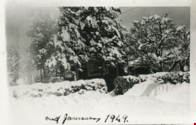
- Photograph of "Campend," the Shankie family home. This photograph was taken following winter snows. The house was formerly numbered 3718 Barker Avenue and later renumbered 5155 Barker Avenue.
- Repository
- City of Burnaby Archives
- Date
- January 1949 (date of original), copied 1986
- Collection/Fonds
- Burnaby Historical Society fonds
- Subseries
- Pioneer Tales subseries
- Physical Description
- 1 photograph : b&w ; 12.7 x 17.8 cm print
- Description Level
- Item
- Record No.
- 204-002
- Access Restriction
- No restrictions
- Reproduction Restriction
- Reproduce for fair dealing purposes only
- Accession Number
- BHS1988-03
- Scope and Content
- Photograph of "Campend," the Shankie family home. This photograph was taken following winter snows. The house was formerly numbered 3718 Barker Avenue and later renumbered 5155 Barker Avenue.
- Subjects
- Natural Phenomena - Snow
- Media Type
- Photograph
- Notes
- Title based on contents of photograph
- Geographic Access
- Barker Avenue
- Street Address
- 5155 Barker Avenue
- Historic Neighbourhood
- Central Park (Historic Neighbourhood)
- Planning Study Area
- Garden Village Area
Images


Switchboard
https://search.heritageburnaby.ca/link/archivedescription34710
- Repository
- City of Burnaby Archives
- Date
- 1943
- Collection/Fonds
- Burnaby Historical Society fonds
- Description Level
- Item
- Physical Description
- 1 photograph : b&w ; 20.0 x 25.5 cm
- Scope and Content
- Photograph of the interior of a switchboard, probably the Dexter exchange at Boundary Road and Kingsway. A typed description on the back of the photograph reads, "A Manual Switchboard, typical of about 25 years ago. / Dexter, 1943. / B.C. Telephone Company."
- Repository
- City of Burnaby Archives
- Date
- 1943
- Collection/Fonds
- Burnaby Historical Society fonds
- Subseries
- Photographs subseries
- Physical Description
- 1 photograph : b&w ; 20.0 x 25.5 cm
- Material Details
- Printed on photo paper: "selo"
- Description Level
- Item
- Record No.
- 114-001
- Access Restriction
- No restrictions
- Reproduction Restriction
- No known restrictions
- Accession Number
- BHS2007-04
- Scope and Content
- Photograph of the interior of a switchboard, probably the Dexter exchange at Boundary Road and Kingsway. A typed description on the back of the photograph reads, "A Manual Switchboard, typical of about 25 years ago. / Dexter, 1943. / B.C. Telephone Company."
- Subjects
- Telecommunication Tools and Equipment
- Buildings - Commercial
- Occupations - Telephone Operators
- Media Type
- Photograph
- Photographer
- Dominion Photo Company
- Notes
- Title based on contents of photograph
- Printed in bottom left corner of photograph, "27038 Dominion Photo Co., Vancouver B.C."
- Geographic Access
- Boundary Road
- Kingsway
- Historic Neighbourhood
- Central Park (Historic Neighbourhood)
- Planning Study Area
- Garden Village Area
Images
