Narrow Results By
![Inter-party meeting at U.B.C., [194-?] thumbnail](/media/hpo/_Data/_BVM_Images/2013/2013_0012_0063_001.jpg?width=280)
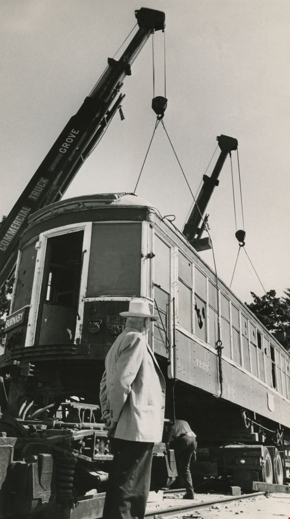
Inter-party meeting at U.B.C.
https://search.heritageburnaby.ca/link/museumdescription3706
- Repository
- Burnaby Village Museum
- Date
- [194-?]
- Collection/Fonds
- Harold Edward Winch collection
- Description Level
- Item
- Physical Description
- 1 photograph : b&w ; 25.6 x 20.9 cm
- Scope and Content
- Item is a photograph of Harold Winch speaking at an inter-party meeting at the University of British Columbia (UBC), Vancouver.
- Repository
- Burnaby Village Museum
- Collection/Fonds
- Harold Edward Winch collection
- Description Level
- Item
- Physical Description
- 1 photograph : b&w ; 25.6 x 20.9 cm
- Scope and Content
- Item is a photograph of Harold Winch speaking at an inter-party meeting at the University of British Columbia (UBC), Vancouver.
- Names
- Winch, Harold Edward
- Geographic Access
- Vancouver
- Accession Code
- BV013.12.63
- Date
- [194-?]
- Media Type
- Photograph
- Notes
- Title based on contents of photograph
- Photograph is a part of original scrapbook Item BV013.12.11
Images
![Inter-party meeting at U.B.C., [194-?] thumbnail](/media/hpo/_Data/_BVM_Images/2013/2013_0012_0063_001.jpg)
Walker family fonds
https://search.heritageburnaby.ca/link/archivedescription78708
- Repository
- City of Burnaby Archives
- Date
- 1948-1957 (date of originals); 2013
- Collection/Fonds
- Walker family fonds
- Description Level
- Fonds
- Physical Description
- 38 photographs (7 jpeg : col., 300 dpi ; 7 jpeg : col., 96 dpi ; 10 jpeg : b&w, 300 dpi ; 12 jpeg : b&w, 96 dpi). 1 drawing (jpeg) : col., 300 dpi ; 2 maps (jpeg) : col. ; 96 dpi ; 397.67 KB of textual records.
- Scope and Content
- Fonds consists of 41 jpegs of original photographs (some include annotation), maps, and newspaper clippings pertaining to Scotty Walker, his family and the Inter-City Driving Range that he created.
- Repository
- City of Burnaby Archives
- Date
- 1948-1957 (date of originals); 2013
- Collection/Fonds
- Walker family fonds
- Physical Description
- 38 photographs (7 jpeg : col., 300 dpi ; 7 jpeg : col., 96 dpi ; 10 jpeg : b&w, 300 dpi ; 12 jpeg : b&w, 96 dpi). 1 drawing (jpeg) : col., 300 dpi ; 2 maps (jpeg) : col. ; 96 dpi ; 397.67 KB of textual records.
- Description Level
- Fonds
- Access Restriction
- No restrictions
- Reproduction Restriction
- May be restricted by third party rights
- Accession Number
- 2013-15
- Scope and Content
- Fonds consists of 41 jpegs of original photographs (some include annotation), maps, and newspaper clippings pertaining to Scotty Walker, his family and the Inter-City Driving Range that he created.
- History
- Scotty Walker purchased the property at 974 12th Avenue in 1948 under the Veteran’s Land Act (VLA) grant from the government. He was in the Air Force during the Second World War. Previous to the purchase he ran a trucking business in New Westminster and lived at 1421 Nanaimo Street. The family consisted of Scotty, his wife Elizabeth, and three children, Alex, Barbara, and James. The land was overgrown with trees, scrub bushes, and a general swampy area. Scotty had the plan to build a Golf Driving Range, but it would take a lot of work. He owned three acres and leased three acres from the Lady of Mercy Church. Then they started working the land. The trees and scrub bush had to be removed and it was all done by hand. As the weather warmed and the swamp dried somewhat, Scotty got the idea to do selective burning. After many times doing this in small sections, the wind changed and the fire was headed for some houses on Tenth Avenue. The fire departments from New Westminster and Burnaby showed up and he was severely punished. It created other problems too. The land was swampy and when it dried, it was a peat bog, so the fire would burn down and turn up all over the place. That winter when the rains came, the land flooded and froze. The kids in the neighbourhood took advantage of the open spaces and brought out their skates. They had a great time. Some pigs were purchased with the idea that they could help dig up the roots and could be butchered later. Well they cleared the roots, but the kids all said they would not eat the pigs. The pigs were sold as they had become like pets. The land was then bulldozed into a berm on the 12th Street side of the land and a fence was built on top of the hill. The Walkers still had to clear the roots and branches that accumulated on the berm. The big problem was snakes. There were pits of water snakes that had been moved with the bulldozing. The family is not sure what happened with the snakes but eventually they moved. The area that would have been to the left of the property was still a swamp, so maybe they went there. The Walkers built drainage ditches through the land and let it drain to the natural slope toward Eighth Street. Construction on the Golf Range started and the grass was seeded. The “Inter-City Golf Range” opened on June 16, 1951. It had been a long hard road for the whole family but it worked out quite well. There was no automatic machine picking up balls, it was all done by hand and washed in a washing machine. Eventually they got Shag Bags that helped some but it was a huge job. The Golf Range ran for a few years and then Burnaby had a very sunny summer and the sun was in the patrons' eyes. So Scotty decided to move the buildings to the 12th Avenue part of the land. The club house and coffee shop was moved. The family took the building apart board by board and reconstructed it at the other end of the land. This worked well. All this had been accomplished on a shoestring budget as there was no big money behind anything. The Walkers cut the grass with gas hand mowers, washed the balls with the washing machine, and worked very long hours. Then the Catholic Church decided not to renew the lease. The family had worked so hard and now Scotty’s dream was dashed. It was a devastating time. Eventually the property was sold to the Christian Brothers and the buildings to Gus Brown in Richmond. The church bought the land for $25,000, in 1957. The end of the dream was very hard on everyone. Eventually life went on. It is sad that Scotty was just so far ahead of his time. He was a small man about 5’6" and about 140 pounds but had dreams as big as anyone and worked like three men to accomplish his dream. The cleared land was eventually developed into Saint Thomas Moore School. Biography provided by B. Kromm
- Media Type
- Photograph
- Creator
- Walker family
- Notes
- Title based on contents of fonds
- Photo catalogue 557

Bird's Eye View of the Burnaby Lake Area
https://search.heritageburnaby.ca/link/museumdescription15144
- Repository
- Burnaby Village Museum
- Date
- 1977
- Collection/Fonds
- Century Park Museum Association fonds
- Description Level
- Item
- Physical Description
- 1 map : b&w print on paper ; 43 x 63.5 cm
- Scope and Content
- Item consists of a map titled "Birds Eye View of the Burnaby Lake Area Circa 1910". The overview of the Burnaby Lake area was compiled and drawn at Heritage Village by curator John Adams and artist, Carol Swan. The map identifies the Burnaby Lake inter-urban tram line; roads including: Sperling Ave…
- Repository
- Burnaby Village Museum
- Collection/Fonds
- Century Park Museum Association fonds
- Description Level
- Item
- Physical Description
- 1 map : b&w print on paper ; 43 x 63.5 cm
- Material Details
- Scale indeterminable
- Scope and Content
- Item consists of a map titled "Birds Eye View of the Burnaby Lake Area Circa 1910". The overview of the Burnaby Lake area was compiled and drawn at Heritage Village by curator John Adams and artist, Carol Swan. The map identifies the Burnaby Lake inter-urban tram line; roads including: Sperling Avenue (Pole Line Road); Gilpin Avenue; Douglas Road; trail to Vancouver Westminster Road (Kingsway); Buckingham Avenue; Haszard Street; various farms and residences including: Charles Sprott "Norland"; H.T. Ceperley "Fairacres"; Claude Hill's "Brookfield farm" and "Broadview"; F.J. Hart's "Avalon"; Miss Woodward's former and new home, school and post office; Councillor Edgar's hunting cabin; Edgar Sprott's "Mayfield farm" and "Mayfield Lodge"; F.J. Peers "Greyfriars"; Arthur de Windt Haszard; Bernard Hill's boathouse as well as other landmarks including: Doran's Mill; tram stations; Burnaby Lake Store; logging camps; wood cutter's shacks; ice houses; cranberry bog; Still Creek; Deer Lake; Burnaby Lake; Deer Lake Creek; Provincial Government Reserve Proposed Hospital (later Oakalla Prison).
- Creator
- Adams, John
- Swan, Carol
- Names
- Hill, Arthur Claude
- Sprott, Charles Frederick
- Sprott, Louis "Edgar"
- Hart, Frederick John, 1884-1945
- Ceperley, H.T.
- Woodward, Maude
- Woodward, Harriet
- Peers, Francis J.
- Haszard, Arthur de Windt
- Hill, Bernard R.
- Geographic Access
- Deer Lake Avenue
- Sperling Avenue
- Haszard Street
- Buckingham Avenue
- Accession Code
- BV021.1.3
- Access Restriction
- No restrictions
- Reproduction Restriction
- No known restrictions
- Date
- 1977
- Media Type
- Cartographic Material
- Historic Neighbourhood
- Burnaby Lake (Historic Neighbourhood)
- Planning Study Area
- Burnaby Lake Area
- Related Material
- See also: Life with the Moores of Hart House : pioneer days on Burnaby's Deer Lake
- Scan Resolution
- 600
- Scan Date
- 2021-11-12
- Scale
- 100
- Notes
- Transcribed title
- Compiled by John Adams; illustration by Carol Swan
- The map depicts the Burnaby Lake Tram Line as being double tracked, whereas in reality it was single tracked.
- Map is part of the book "Life with the Moores of Hart House : pioneer days on Burnaby's Deer Lake https://search.heritageburnaby.ca/permalink/museumlibrary6314-102
Images


Bird's Eye View of the Burnaby Lake Area
https://search.heritageburnaby.ca/link/museumdescription17543
- Repository
- Burnaby Village Museum
- Date
- 1977
- Collection/Fonds
- Century Park Museum Association fonds
- Description Level
- Item
- Physical Description
- 1 map : b&w print with watercolour ; 43 x 63.5 cm
- Scope and Content
- Item consists of a map titled "Birds Eye View of the Burnaby Lake Area Circa 1910". The overview of the Burnaby Lake area was compiled and drawn at Heritage Village by curator John Adams and artist, Carol Swan. The map identifies the Burnaby Lake inter-urban tram line; roads including: Sperling Ave…
- Repository
- Burnaby Village Museum
- Collection/Fonds
- Century Park Museum Association fonds
- Description Level
- Item
- Physical Description
- 1 map : b&w print with watercolour ; 43 x 63.5 cm
- Material Details
- Scale indeterminable
- Scope and Content
- Item consists of a map titled "Birds Eye View of the Burnaby Lake Area Circa 1910". The overview of the Burnaby Lake area was compiled and drawn at Heritage Village by curator John Adams and artist, Carol Swan. The map identifies the Burnaby Lake inter-urban tram line; roads including: Sperling Avenue (Pole Line Road); Gilpin Avenue; Douglas Road; trail to Vancouver Westminster Road (Kingsway); Buckingham Avenue; Haszard Street; various farms and residences including: Charles Sprott "Norland"; H.T. Ceperley "Fairacres"; Claude Hill's "Brookfield farm" and "Broadview"; F.J. Hart's "Avalon"; Miss Woodward's former and new home, school and post office; Councillor Edgar's hunting cabin; Edgar Sprott's "Mayfield farm" and "Mayfield Lodge"; F.J. Peers "Greyfriars"; Arthur de Windt Haszard; Bernard Hill's boathouse as well as other landmarks including: Doran's Mill; tram stations; Burnaby Lake Store; logging camps; wood cutter's shacks; ice houses; cranberry bog; Still Creek; Deer Lake; Burnaby Lake; Deer Lake Creek; Provincial Government Reserve Proposed Hospital (later Oakalla Prison).
- Creator
- Adams, John
- Swan, Carol
- Names
- Hill, Arthur Claude
- Sprott, Charles Frederick
- Sprott, Louis "Edgar"
- Hart, Frederick John, 1884-1945
- Ceperley, H.T.
- Woodward, Maude
- Woodward, Harriet
- Peers, Francis J.
- Haszard, Arthur de Windt
- Hill, Bernard R.
- Geographic Access
- Deer Lake Avenue
- Sperling Avenue
- Haszard Street
- Buckingham Avenue
- Accession Code
- BV021.1.4
- Access Restriction
- No restrictions
- Reproduction Restriction
- No known restrictions
- Date
- 1977
- Media Type
- Cartographic Material
- Historic Neighbourhood
- Burnaby Lake (Historic Neighbourhood)
- Planning Study Area
- Burnaby Lake Area
- Related Material
- See also: Life with the Moores of Hart House : pioneer days on Burnaby's Deer Lake
- Scan Resolution
- 600
- Scan Date
- 2021-11-12
- Scale
- 100
- Notes
- Transcribed title
- Compiled by John Adams; illustration by Carol Swan
- The map depicts the Burnaby Lake Tram Line as being double tracked, whereas in reality it was single tracked.
- Map is part of the book "Life with the Moores of Hart House : pioneer days on Burnaby's Deer Lake https://search.heritageburnaby.ca/permalink/museumlibrary6314-102
- This is a print made from original illustration and appears to be hand-coloured with watercolour at a later date.
Images

![Libonati's Gun Shop exterior, [1970] thumbnail](/media/hpo/_Data/_Archives_Images/_Unrestricted/513/522-001.JPG?width=280)
Libonati's Gun Shop exterior
https://search.heritageburnaby.ca/link/archivedescription66101
- Repository
- City of Burnaby Archives
- Date
- [1970]
- Collection/Fonds
- Libonati family fonds
- Description Level
- Item
- Physical Description
- 1 photograph (jpeg)
- Scope and Content
- Photograph depicts an exterior view of Libonati's Gun Shop and Sporting Goods at 4261 Kingsway, along with other businesses on that block. Businesses left to right: Quality Auto Electric, Libonati's Gun Shop and Sporting Goods and Inter City Bowl bowling alley. Not shown in the picture were two o…
- Repository
- City of Burnaby Archives
- Date
- [1970]
- Collection/Fonds
- Libonati family fonds
- Physical Description
- 1 photograph (jpeg)
- Description Level
- Item
- Record No.
- 522-001
- Access Restriction
- No restrictions
- Reproduction Restriction
- Reproduce for fair dealing purposes only
- Accession Number
- 2011-02
- Scope and Content
- Photograph depicts an exterior view of Libonati's Gun Shop and Sporting Goods at 4261 Kingsway, along with other businesses on that block. Businesses left to right: Quality Auto Electric, Libonati's Gun Shop and Sporting Goods and Inter City Bowl bowling alley. Not shown in the picture were two other business east of the bowling alley; namely, Low Cost Transmission and Kilpatrick Nursing Home which was at the corner of Chaffey before Chaffey was realigned. Libonati's Gun Shop was owned and operated by Denzil (Dan) Libonati, a long-time Burnaby businessman. Cars in the picture are a 1959 Willy's Jeep (Denzil's) and 1958 Chevrolet (unknown owner).
- Names
- Libonati's Gun Shop
- Media Type
- Photograph
- Geographic Access
- Kingsway
- Street Address
- 4261 Kingsway
- Historic Neighbourhood
- Central Park (Historic Neighbourhood)
- Planning Study Area
- Maywood Area
Images
![Libonati's Gun Shop exterior, [1970] thumbnail](/media/hpo/_Data/_Archives_Images/_Unrestricted/513/522-001.JPG)
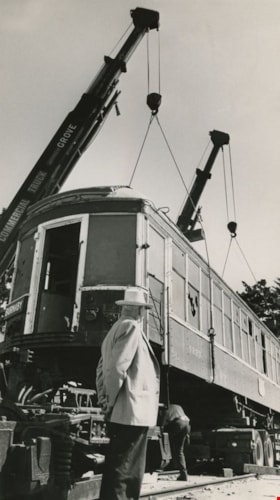
Tram 1223 being moved to Burnaby's Centennial Heritage Village
https://search.heritageburnaby.ca/link/archivedescription36099
- Repository
- City of Burnaby Archives
- Date
- July 17, 1971
- Collection/Fonds
- Burnaby Historical Society fonds
- Description Level
- Item
- Physical Description
- 1 photograph : b&w ; 24.5 x 13.5 cm
- Scope and Content
- Photograph of British Columbia Electric Railway Company tram 1223 being moved from Edmonds Loop to Burnaby's Centennial Heritage Village, where it became a permanent archive. A man looks on as a railworker moves under the tram just as two large cranes lift it into the air.
- Repository
- City of Burnaby Archives
- Date
- July 17, 1971
- Collection/Fonds
- Burnaby Historical Society fonds
- Subseries
- Columbian Newspaper subseries
- Physical Description
- 1 photograph : b&w ; 24.5 x 13.5 cm
- Description Level
- Item
- Record No.
- 222-022
- Access Restriction
- No restrictions
- Reproduction Restriction
- Reproduce for fair dealing purposes only
- Accession Number
- BHS1989-19
- Scope and Content
- Photograph of British Columbia Electric Railway Company tram 1223 being moved from Edmonds Loop to Burnaby's Centennial Heritage Village, where it became a permanent archive. A man looks on as a railworker moves under the tram just as two large cranes lift it into the air.
- Media Type
- Photograph
- Notes
- Title based on contents of photograph
- Newspaper clipping glued to verso of photograph reads: "It took two cranes and about three hours to transport old B.C. Electric inter-urban tram car from it's former home at Edmonds Loop to it's new home at Burnaby's Centennial Heritage Village. Tram is to be a permanent archive at the village.
- July 17, 1971 is stamped on verso of photograph, overtop of the newspaper article
Images