More like 'Apartments at 5220 Capitol Drive'
Narrow Results By
Decade
- 2020s 96
- 2010s 43
- 2000s 481
- 1990s 398
- 1980s 405
- 1970s
- 1960s 280
- 1950s 463
- 1940s
- 1930s 349
- 1920s 373
- 1910s 445
- 1900s 173
- 1890s 23
- 1880s 49
- 1870s 3
- 1860s 1
- 1850s 1
- 1840s 1
- 1830s 1
- 1820s 1
- 1810s 1
- 1800s 1
- 1790s 1
- 1780s 1
- 1770s 1
- 1760s 1
- 1750s 1
- 1740s 1
- 1730s 1
- 1720s 1
- 1710s 1
- 1700s 1
- 1690s 1
- 1680s 1
- 1670s 1
- 1660s 1
- 1650s 1
- 1640s 1
- 1630s 1
- 1620s 1
- 1610s 1
- 1600s 1

Capitol Hill Community Hall
https://search.heritageburnaby.ca/link/landmark563
- Repository
- Burnaby Heritage Planning
- Description
- Public building.
- Associated Dates
- 1948
- Street View URL
- Google Maps Street View
- Repository
- Burnaby Heritage Planning
- Geographic Access
- Howard Avenue
- Associated Dates
- 1948
- Description
- Public building.
- Heritage Value
- The Capitol Hill Community Hall was designed by local architect Harold Cullerne (1890-1976). After Cullerne returned from service during the First World War, he joined J.H. Bowman in a partnership that lasted from 1919 to 1934. After Bowman retired in 1934, Cullerne practiced on his own, continuing to work on schools and institutional buildings, such as the Art Deco Hollywood Theatre in Vancouver. In 1944, Cullerne designed a community hall for Capitol Hill; the scheme was delayed, and redesigned before it was finally built after the end of the Second World War. A simple front gabled roof hall structure, this hall is a monument to community spirit, erected by community members on a volunteer basis, and used for community events for over half a century. The hall replaced two earlier structures, both destroyed by fire, that had served the same purpose.
- Locality
- Capitol Hill
- Historic Neighbourhood
- Capitol Hill (Historic Neighbourhood)
- Planning Study Area
- Capitol Hill Area
- Architect
- Harold Cullerne
- Ownership
- Public (local)
- Street Address
- 361 Howard Avenue
- Street View URL
- Google Maps Street View
Images


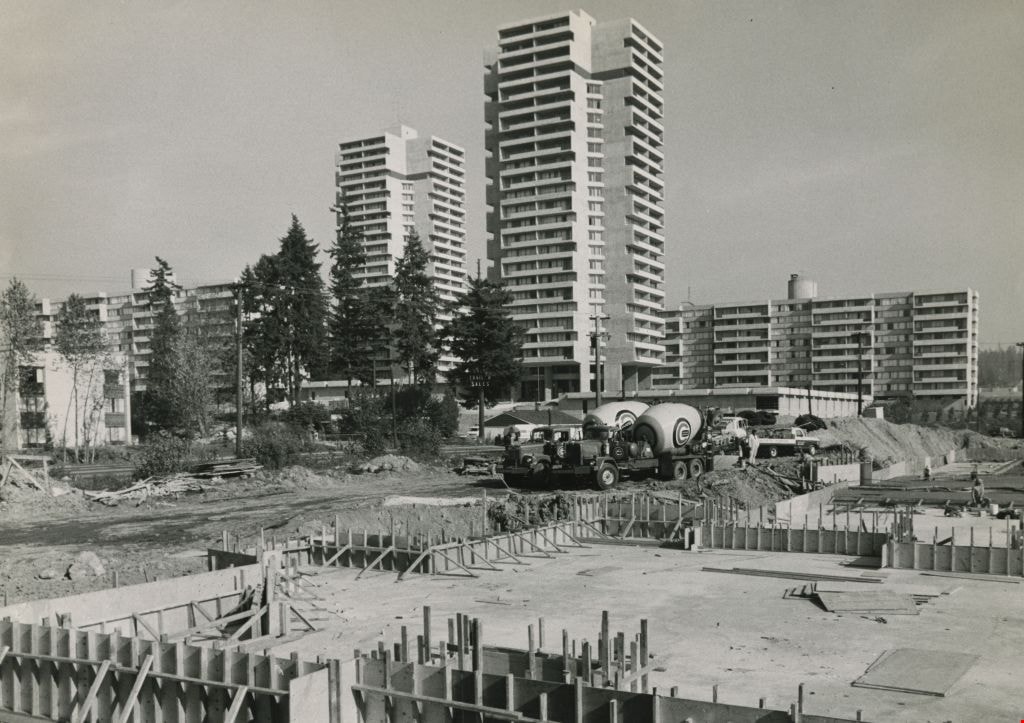
High-rise at Kingsway and Edmonds
https://search.heritageburnaby.ca/link/archivedescription45986
- Repository
- City of Burnaby Archives
- Date
- 1979
- Collection/Fonds
- Columbian Newspaper collection
- Description Level
- Item
- Physical Description
- 1 photograph : b&w ; 17 x 18.5 cm
- Scope and Content
- Photograph of the construction of a "senior citizen's" high-rise at Kingsway and Edmonds.
- Repository
- City of Burnaby Archives
- Date
- 1979
- Collection/Fonds
- Columbian Newspaper collection
- Physical Description
- 1 photograph : b&w ; 17 x 18.5 cm
- Description Level
- Item
- Record No.
- 480-881
- Access Restriction
- No restrictions
- Reproduction Restriction
- Reproduce for fair dealing purposes only
- Accession Number
- 2003-02
- Scope and Content
- Photograph of the construction of a "senior citizen's" high-rise at Kingsway and Edmonds.
- Subjects
- Construction
- Buildings - Residential - Apartments
- Buildings - Residential - Seniors Housing
- Media Type
- Photograph
- Photographer
- Symonds, John
- Notes
- Title based on contents of photograph
- Newspaper clipping attached to verso of photograph reads: "New senior citizen's high-rise is rapidly taking shape at Kingsway and Edmonds in Burnaby. Burnaby municipal council is currently considering plans for construction of a senior citizen's recreation centre ajoining the site."
- Geographic Access
- Kingsway
- Edmonds Street
- Historic Neighbourhood
- Edmonds (Historic Neighbourhood)
- Planning Study Area
- Richmond Park Area
Images


Norman Bethune Housing Cooperative
https://search.heritageburnaby.ca/link/archivedescription56667
- Repository
- City of Burnaby Archives
- Date
- November 1976
- Collection/Fonds
- Columbian Newspaper collection
- Description Level
- Item
- Physical Description
- 1 photograph : b&w ; 15 x 19.5 cm
- Scope and Content
- Photograph of Larry Whaley, then president of the Norman Bethune Housing Cooperative, standing outside the housing complex where he lived. At the time, only 24 units were inhabited by members while the other 282 units that were supposed to be opened up in the second stage of the project were vacant…
- Repository
- City of Burnaby Archives
- Date
- November 1976
- Collection/Fonds
- Columbian Newspaper collection
- Physical Description
- 1 photograph : b&w ; 15 x 19.5 cm
- Description Level
- Item
- Record No.
- 480-1253
- Access Restriction
- No restrictions
- Reproduction Restriction
- No restrictions
- Accession Number
- 2003-02
- Scope and Content
- Photograph of Larry Whaley, then president of the Norman Bethune Housing Cooperative, standing outside the housing complex where he lived. At the time, only 24 units were inhabited by members while the other 282 units that were supposed to be opened up in the second stage of the project were vacant due to a misunderstanding between the provincial and federal governments, and the allocation of nine million dollars that had been sent aside in 1973 for for rental housing in Burnaby.
- Names
- Whaley, Larry
- Media Type
- Photograph
- Photographer
- King, Basil
- Notes
- Title based on contents of photograph
- Newspaper clipping attached to verso of photograph reads: "Larry Whaley ponders what will happen to Bethune Co-Op Housing in Simon Fraser Hills area."
- Geographic Access
- Centaurus Circle
- Street Address
- 8752 Centaurus Circle
- Historic Neighbourhood
- Burquitlam (Historic Neighbourhood)
- Planning Study Area
- Lyndhurst Area
Images


Highrises on Kingsway
https://search.heritageburnaby.ca/link/archivedescription93692
- Repository
- City of Burnaby Archives
- Date
- June 4, 1978
- Collection/Fonds
- Burnaby Public Library Contemporary Visual Archive Project
- Description Level
- Item
- Physical Description
- 1 photograph : b&w ; 12.5 x 17.5 cm
- Scope and Content
- Photograph of high-rises apartment buildings and the neighbourhood along Kingsway by Central Park. The photograph is taken from a high point, facing east down Kingsway. The Central Park Veterinary Hospital, Central Park Place, a railway crossing, a gas station, and the Central Park Gate are visible…
- Repository
- City of Burnaby Archives
- Date
- June 4, 1978
- Collection/Fonds
- Burnaby Public Library Contemporary Visual Archive Project
- Physical Description
- 1 photograph : b&w ; 12.5 x 17.5 cm
- Description Level
- Item
- Record No.
- 556-649
- Access Restriction
- No restrictions
- Reproduction Restriction
- Reproduce for fair dealing purposes only
- Accession Number
- 2017-57
- Scope and Content
- Photograph of high-rises apartment buildings and the neighbourhood along Kingsway by Central Park. The photograph is taken from a high point, facing east down Kingsway. The Central Park Veterinary Hospital, Central Park Place, a railway crossing, a gas station, and the Central Park Gate are visible in the photograph.
- Subjects
- Buildings - Commercial
- Buildings - Residential - Apartments
- Buildings - Commercial - Service Stations
- Geographic Features - Parks
- Monuments
- Media Type
- Photograph
- Photographer
- Chapman, Fred
- Notes
- Title taken from project information form
- Accompanied by a project information form and 1 photograph (b&w negative ; 9.5 x 12.5 cm)
- BPL no. 97
- Geographic Access
- Kingsway
- Central Park
- Historic Neighbourhood
- Central Park (Historic Neighbourhood)
- Planning Study Area
- Maywood Area
Images


Old Orchard Shopping Centre
https://search.heritageburnaby.ca/link/archivedescription93602
- Repository
- City of Burnaby Archives
- Date
- October 9, 1977
- Collection/Fonds
- Burnaby Public Library Contemporary Visual Archive Project
- Description Level
- Item
- Physical Description
- 1 photograph : b&w ; 12.5 x 17.5 cm
- Scope and Content
- Photograph of the Old Orchard Shopping Centre, located at Kingsway and Willingdon. The photograph is taken from across the intersection, facing northwest, and shows an IGA and a high-rise apartment building in the background.
- Repository
- City of Burnaby Archives
- Date
- October 9, 1977
- Collection/Fonds
- Burnaby Public Library Contemporary Visual Archive Project
- Physical Description
- 1 photograph : b&w ; 12.5 x 17.5 cm
- Description Level
- Item
- Record No.
- 556-559
- Access Restriction
- No restrictions
- Reproduction Restriction
- Reproduce for fair dealing purposes only
- Accession Number
- 2017-57
- Scope and Content
- Photograph of the Old Orchard Shopping Centre, located at Kingsway and Willingdon. The photograph is taken from across the intersection, facing northwest, and shows an IGA and a high-rise apartment building in the background.
- Subjects
- Buildings - Commercial - Malls
- Buildings - Commercial - Grocery Stores
- Buildings - Residential - Apartments
- Media Type
- Photograph
- Photographer
- Chapman, Fred
- Notes
- Title taken from project information form
- Accompanied by a project information form and 1 photograph (b&w negative ; 9.5 x 12.5 cm)
- BPL no. 3
- Geographic Access
- Kingsway
- Street Address
- 4469 Kingsway
- Historic Neighbourhood
- Central Park (Historic Neighbourhood)
- Planning Study Area
- Maywood Area
Images


Old Orchard Shopping Centre
https://search.heritageburnaby.ca/link/archivedescription93603
- Repository
- City of Burnaby Archives
- Date
- October 9, 1977
- Collection/Fonds
- Burnaby Public Library Contemporary Visual Archive Project
- Description Level
- Item
- Physical Description
- 1 photograph : b&w ; 12.5 x 17.5 cm
- Scope and Content
- Photograph of the Old Orchard Shopping Centre, located at Kingsway and Willingdon. The photograph is taken from across the road, facing northwest, and focuses on the shopping centre sign. The other stores' signs, including Shoppers Drug Mart and Autoplan, and a high-rise apartment building are visi…
- Repository
- City of Burnaby Archives
- Date
- October 9, 1977
- Collection/Fonds
- Burnaby Public Library Contemporary Visual Archive Project
- Physical Description
- 1 photograph : b&w ; 12.5 x 17.5 cm
- Description Level
- Item
- Record No.
- 556-560
- Access Restriction
- No restrictions
- Reproduction Restriction
- Reproduce for fair dealing purposes only
- Accession Number
- 2017-57
- Scope and Content
- Photograph of the Old Orchard Shopping Centre, located at Kingsway and Willingdon. The photograph is taken from across the road, facing northwest, and focuses on the shopping centre sign. The other stores' signs, including Shoppers Drug Mart and Autoplan, and a high-rise apartment building are visible in the background.
- Subjects
- Buildings - Commercial - Malls
- Advertising Medium - Signs and Signboards
- Buildings - Residential - Apartments
- Media Type
- Photograph
- Photographer
- Chapman, Fred
- Notes
- Title taken from project information form
- Accompanied by a project information form and 1 photograph (b&w negative ; 9.5 x 12.5 cm)
- BPL no. 4
- Geographic Access
- Kingsway
- Street Address
- 4469 Kingsway
- Historic Neighbourhood
- Central Park (Historic Neighbourhood)
- Planning Study Area
- Maywood Area
Images


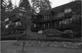
Royal Oak Apartments
https://search.heritageburnaby.ca/link/archivedescription34604
- Repository
- City of Burnaby Archives
- Date
- April 1973
- Collection/Fonds
- Burnaby Historical Society fonds
- Description Level
- Item
- Physical Description
- 1 photograph : col. slide ; 5.0 x 5.0 cm
- Scope and Content
- Photograph of the former Royal Oak Hotel at 3501 Kingsway (renumbered as the 5000 block of Kingsway) and Royal Oak Avenue, with Vancouver Business Maintenance and The Royal Oak Apartments now located in the building.
- Repository
- City of Burnaby Archives
- Date
- April 1973
- Collection/Fonds
- Burnaby Historical Society fonds
- Subseries
- Photographs subseries
- Physical Description
- 1 photograph : col. slide ; 5.0 x 5.0 cm
- Description Level
- Item
- Record No.
- 066-008
- Access Restriction
- No restrictions
- Reproduction Restriction
- Reproduce for fair dealing purposes only
- Accession Number
- BHS2007-04
- Scope and Content
- Photograph of the former Royal Oak Hotel at 3501 Kingsway (renumbered as the 5000 block of Kingsway) and Royal Oak Avenue, with Vancouver Business Maintenance and The Royal Oak Apartments now located in the building.
- Names
- Royal Oak Hotel
- Media Type
- Photograph
- Notes
- Title based on contents of photograph
- Geographic Access
- Kingsway
- Royal Oak Avenue
- Historic Neighbourhood
- Central Park (Historic Neighbourhood)
- Planning Study Area
- Maywood Area
Images

![Royal Oak Apartments, [April 1973] thumbnail](/media/hpo/_Data/_BVM_Images/1985/1985_6063_0001_001.jpg?width=280)
Royal Oak Apartments
https://search.heritageburnaby.ca/link/museumdescription1678
- Repository
- Burnaby Village Museum
- Date
- [April 1973]
- Collection/Fonds
- Burnaby Village Museum Photograph collection
- Description Level
- Item
- Physical Description
- 1 photograph : col. ; 8 x 11.5 cm
- Scope and Content
- Photograph of the former Royal Oak Hotel at 3501 Kingsway (renumbered as the 5000 block of Kingsway) and Royal Oak Avenue, with Vancouver Business Maintenance and The Royal Oak Apartments now located in the building.
- Repository
- Burnaby Village Museum
- Collection/Fonds
- Burnaby Village Museum Photograph collection
- Description Level
- Item
- Physical Description
- 1 photograph : col. ; 8 x 11.5 cm
- Scope and Content
- Photograph of the former Royal Oak Hotel at 3501 Kingsway (renumbered as the 5000 block of Kingsway) and Royal Oak Avenue, with Vancouver Business Maintenance and The Royal Oak Apartments now located in the building.
- Names
- Royal Oak Hotel
- Geographic Access
- Kingsway
- Royal Oak Avenue
- Accession Code
- BV985.6063.1
- Access Restriction
- No restrictions
- Reproduction Restriction
- May be restricted by third party rights
- Date
- [April 1973]
- Media Type
- Photograph
- Historic Neighbourhood
- Central Park (Historic Neighbourhood)
- Planning Study Area
- Marlborough Area
- Scan Resolution
- 600
- Scan Date
- 2024-03-05
- Scale
- 100
- Photographer
- Street, Frank
- Notes
- Title based on contents of photograph
- Note written in blue ballpoint pen on verso of photograph reads: "TAKEN BY FRANK STREET"
Images
![Royal Oak Apartments, [April 1973] thumbnail](/media/hpo/_Data/_BVM_Images/1985/1985_6063_0001_001.jpg)

Apartment at 390 Howard Avenue
https://search.heritageburnaby.ca/link/archivedescription79027
- Repository
- City of Burnaby Archives
- Date
- September 5, 1976
- Collection/Fonds
- Burnaby Public Library Contemporary Visual Archive Project
- Description Level
- Item
- Physical Description
- 1 photograph : b&w ; 11 x 16 cm mounted on cardboard
- Scope and Content
- Photograph shows an apartment complex alongside The Tailwagger, a boutique and grooming salon for dogs, at 390 Howard Avenue near Hastings Street. A "Canada Agriculture" car is parked outside.
- Repository
- City of Burnaby Archives
- Date
- September 5, 1976
- Collection/Fonds
- Burnaby Public Library Contemporary Visual Archive Project
- Physical Description
- 1 photograph : b&w ; 11 x 16 cm mounted on cardboard
- Description Level
- Item
- Record No.
- 556-099
- Access Restriction
- No restrictions
- Reproduction Restriction
- Reproduce for fair dealing purposes only
- Accession Number
- 2013-13
- Scope and Content
- Photograph shows an apartment complex alongside The Tailwagger, a boutique and grooming salon for dogs, at 390 Howard Avenue near Hastings Street. A "Canada Agriculture" car is parked outside.
- Subjects
- Buildings - Residential - Apartments
- Media Type
- Photograph
- Notes
- Scope note taken directly from BPL photograph description.
- 1 b&w copy negative : 10 x 12.5 cm accompanying
- Photographers identified by surnames only: Carr and Vardeman
- Geographic Access
- Howard Avenue
- Street Address
- 390 Howard Avenue
- Historic Neighbourhood
- Capitol Hill (Historic Neighbourhood)
- Planning Study Area
- Capitol Hill Area
Images


Apartment at Albert and Ingleton
https://search.heritageburnaby.ca/link/archivedescription79031
- Repository
- City of Burnaby Archives
- Date
- September 12, 1976
- Collection/Fonds
- Burnaby Public Library Contemporary Visual Archive Project
- Description Level
- Item
- Physical Description
- 1 photograph : b&w ; 11 x 16 cm mounted on cardboard
- Scope and Content
- Photograph shows a sign on an apartment building on Albert Street near Ingleton Avenue.
- Repository
- City of Burnaby Archives
- Date
- September 12, 1976
- Collection/Fonds
- Burnaby Public Library Contemporary Visual Archive Project
- Physical Description
- 1 photograph : b&w ; 11 x 16 cm mounted on cardboard
- Description Level
- Item
- Record No.
- 556-102
- Access Restriction
- No restrictions
- Reproduction Restriction
- Reproduce for fair dealing purposes only
- Accession Number
- 2013-13
- Scope and Content
- Photograph shows a sign on an apartment building on Albert Street near Ingleton Avenue.
- Media Type
- Photograph
- Notes
- Scope note taken directly from BPL photograph description.
- 1 b&w copy negative : 10 x 12.5 cm accompanying
- Photographers identified by surnames only: Carr and Vardeman
- Geographic Access
- Albert Street
- Ingleton Avenue
- Historic Neighbourhood
- Vancouver Heights (Historic Neighbourhood)
- Planning Study Area
- Burnaby Heights Area
Images


Apartment at Gilley and Kingsway
https://search.heritageburnaby.ca/link/archivedescription79023
- Repository
- City of Burnaby Archives
- Date
- October 14, 1976
- Collection/Fonds
- Burnaby Public Library Contemporary Visual Archive Project
- Description Level
- Item
- Physical Description
- 1 photograph : b&w ; 11 x 16 cm mounted on cardboard
- Scope and Content
- Photograph shows apartment building located at the northeast corner of Gilley Avenue and Kingsway.
- Repository
- City of Burnaby Archives
- Date
- October 14, 1976
- Collection/Fonds
- Burnaby Public Library Contemporary Visual Archive Project
- Physical Description
- 1 photograph : b&w ; 11 x 16 cm mounted on cardboard
- Description Level
- Item
- Record No.
- 556-097
- Access Restriction
- No restrictions
- Reproduction Restriction
- Reproduce for fair dealing purposes only
- Accession Number
- 2013-13
- Scope and Content
- Photograph shows apartment building located at the northeast corner of Gilley Avenue and Kingsway.
- Subjects
- Buildings - Residential - Apartments
- Media Type
- Photograph
- Photographer
- Norton, Paul
- Notes
- Scope note taken directly from BPL photograph description.
- 1 b&w copy negative : 10 x 12.5 cm accompanying
- Geographic Access
- Kingsway
- Gilley Avenue
- Street Address
- 6355 Kingsway
- Historic Neighbourhood
- Edmonds (Historic Neighbourhood)
- Planning Study Area
- Kingsway-Beresford Area
Images


Apartment at Maywood and Patterson
https://search.heritageburnaby.ca/link/archivedescription79030
- Repository
- City of Burnaby Archives
- Date
- September 22, 1976
- Collection/Fonds
- Burnaby Public Library Contemporary Visual Archive Project
- Description Level
- Item
- Physical Description
- 1 photograph : b&w ; 11 x 16 cm mounted on cardboard
- Scope and Content
- Photograph shows an apartment building called Times Square located at the corner of Maywood Street and Patterson Avenue.
- Repository
- City of Burnaby Archives
- Date
- September 22, 1976
- Collection/Fonds
- Burnaby Public Library Contemporary Visual Archive Project
- Physical Description
- 1 photograph : b&w ; 11 x 16 cm mounted on cardboard
- Description Level
- Item
- Record No.
- 556-101
- Access Restriction
- No restrictions
- Reproduction Restriction
- Reproduce for fair dealing purposes only
- Accession Number
- 2013-13
- Scope and Content
- Photograph shows an apartment building called Times Square located at the corner of Maywood Street and Patterson Avenue.
- Subjects
- Buildings - Residential - Apartments
- Media Type
- Photograph
- Photographer
- McCarron, John
- Notes
- Scope note taken directly from BPL photograph description.
- 1 b&w copy negative : 10 x 12.5 cm accompanying
- Geographic Access
- Maywood Street
- Patterson Avenue
- Historic Neighbourhood
- Central Park (Historic Neighbourhood)
- Planning Study Area
- Maywood Area
Images


Burnaby Centre
https://search.heritageburnaby.ca/link/archivedescription79941
- Repository
- City of Burnaby Archives
- Date
- September 27, 1976
- Collection/Fonds
- Burnaby Public Library Contemporary Visual Archive Project
- Description Level
- Item
- Physical Description
- 1 photograph : b&w ; 11 x 16 cm mounted on cardboard
- Scope and Content
- Photograph shows an aerial view of Burnaby Centre looking east from Central Park Place. Kingsway is on the right and Grange Street is on the left.
- Repository
- City of Burnaby Archives
- Date
- September 27, 1976
- Collection/Fonds
- Burnaby Public Library Contemporary Visual Archive Project
- Physical Description
- 1 photograph : b&w ; 11 x 16 cm mounted on cardboard
- Description Level
- Item
- Record No.
- 556-512
- Access Restriction
- No restrictions
- Reproduction Restriction
- Reproduce for fair dealing purposes only
- Accession Number
- 2013-13
- Scope and Content
- Photograph shows an aerial view of Burnaby Centre looking east from Central Park Place. Kingsway is on the right and Grange Street is on the left.
- Media Type
- Photograph
- Photographer
- Norton, Paul
- Notes
- Scope note taken directly from BPL photograph description.
- 1 b&w copy negative : 10 x 12.5 cm accompanying
- Geographic Access
- Kingsway
- Grange Street
- Historic Neighbourhood
- Central Park (Historic Neighbourhood)
- Planning Study Area
- Maywood Area
Images


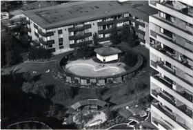
Central Park Place
https://search.heritageburnaby.ca/link/archivedescription79025
- Repository
- City of Burnaby Archives
- Date
- September 27, 1976
- Collection/Fonds
- Burnaby Public Library Contemporary Visual Archive Project
- Description Level
- Item
- Physical Description
- 1 photograph : b&w ; 11 x 16 cm mounted on cardboard
- Scope and Content
- Photograph shows an aerial view of one of the two high-rise apartments of Central Park Place. This building, located at 4160 Sardis Street, was built in 1975 by Narod Developments.
- Repository
- City of Burnaby Archives
- Date
- September 27, 1976
- Collection/Fonds
- Burnaby Public Library Contemporary Visual Archive Project
- Physical Description
- 1 photograph : b&w ; 11 x 16 cm mounted on cardboard
- Description Level
- Item
- Record No.
- 556-098
- Access Restriction
- No restrictions
- Reproduction Restriction
- Reproduce for fair dealing purposes only
- Accession Number
- 2013-13
- Scope and Content
- Photograph shows an aerial view of one of the two high-rise apartments of Central Park Place. This building, located at 4160 Sardis Street, was built in 1975 by Narod Developments.
- Subjects
- Buildings - Residential - Apartments
- Media Type
- Photograph
- Photographer
- Norton, Paul
- Notes
- Scope note taken directly from BPL photograph description.
- 1 b&w copy negative : 10 x 12.5 cm accompanying
- Geographic Access
- Sardis Street
- Street Address
- 4160 Sardis Street
- Historic Neighbourhood
- Central Park (Historic Neighbourhood)
- Planning Study Area
- Garden Village Area
Images

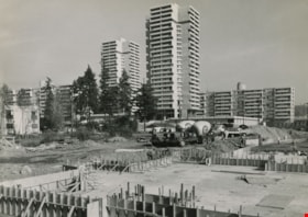
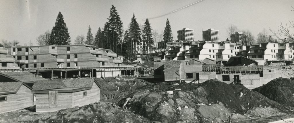
Construction of a high-rise
https://search.heritageburnaby.ca/link/archivedescription45412
- Repository
- City of Burnaby Archives
- Date
- October 1974
- Collection/Fonds
- Columbian Newspaper collection
- Description Level
- Item
- Physical Description
- 1 photograph : b&w ; 17 x 24 cm
- Scope and Content
- Photograph of high-rise buildings in Burnaby; in the foreground, another is being constructed.
- Repository
- City of Burnaby Archives
- Date
- October 1974
- Collection/Fonds
- Columbian Newspaper collection
- Physical Description
- 1 photograph : b&w ; 17 x 24 cm
- Description Level
- Item
- Record No.
- 480-307
- Access Restriction
- No restrictions
- Reproduction Restriction
- No restrictions
- Accession Number
- 2003-02
- Scope and Content
- Photograph of high-rise buildings in Burnaby; in the foreground, another is being constructed.
- Subjects
- Buildings - Residential - Apartments
- Media Type
- Photograph
- Photographer
- King, Basil
- Notes
- Title based on contents of photograph
- Newspaper clipping attached to verso of photograph reads: "How high should a high-rise be is the controversial question in Burnaby."
Images
Construction of MacInnis Place
https://search.heritageburnaby.ca/link/archivedescription45408
- Repository
- City of Burnaby Archives
- Date
- March 1976
- Collection/Fonds
- Columbian Newspaper collection
- Description Level
- Item
- Physical Description
- 1 photograph : b&w ; 10 x 24.5 cm
- Scope and Content
- Photograph of the construction of MacInnis Place in Burnaby. This housing development was constructed with the intent of having 25% of its suites rented at a reduced cost to low income earners.
- Repository
- City of Burnaby Archives
- Date
- March 1976
- Collection/Fonds
- Columbian Newspaper collection
- Physical Description
- 1 photograph : b&w ; 10 x 24.5 cm
- Description Level
- Item
- Record No.
- 480-303
- Access Restriction
- No restrictions
- Reproduction Restriction
- No restrictions
- Accession Number
- 2003-02
- Scope and Content
- Photograph of the construction of MacInnis Place in Burnaby. This housing development was constructed with the intent of having 25% of its suites rented at a reduced cost to low income earners.
- Names
- MacInnis Place
- Media Type
- Photograph
- Photographer
- King, Basil
- Notes
- Title based on contents of photograph
- Geographic Access
- Keswick Avenue
- Historic Neighbourhood
- Burquitlam (Historic Neighbourhood)
- Planning Study Area
- Cameron Area
Images

Construction of MacInnis Place
https://search.heritageburnaby.ca/link/archivedescription45409
- Repository
- City of Burnaby Archives
- Date
- March 1976
- Collection/Fonds
- Columbian Newspaper collection
- Description Level
- Item
- Physical Description
- 1 photograph : b&w ; 11.5 x 24.5 cm
- Scope and Content
- Photograph of the construction of MacInnis Place in Burnaby. This housing development was constructed with the intent of having 25% of its suites rented at a reduced cost to low income earners.
- Repository
- City of Burnaby Archives
- Date
- March 1976
- Collection/Fonds
- Columbian Newspaper collection
- Physical Description
- 1 photograph : b&w ; 11.5 x 24.5 cm
- Description Level
- Item
- Record No.
- 480-304
- Access Restriction
- No restrictions
- Reproduction Restriction
- No restrictions
- Accession Number
- 2003-02
- Scope and Content
- Photograph of the construction of MacInnis Place in Burnaby. This housing development was constructed with the intent of having 25% of its suites rented at a reduced cost to low income earners.
- Names
- MacInnis Place
- Media Type
- Photograph
- Photographer
- King, Basil
- Notes
- Title based on contents of photograph
- Geographic Access
- Keswick Avenue
- Historic Neighbourhood
- Burquitlam (Historic Neighbourhood)
- Planning Study Area
- Cameron Area
Images


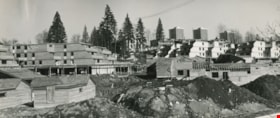
Construction on Acorn Avenue
https://search.heritageburnaby.ca/link/archivedescription79040
- Repository
- City of Burnaby Archives
- Date
- October 20, 1976
- Collection/Fonds
- Burnaby Public Library Contemporary Visual Archive Project
- Description Level
- Item
- Physical Description
- 1 photograph : b&w ; 11 x 16 cm mounted on cardboard
- Scope and Content
- Photograph shows a view from Hall Towers of houses and a high-rise under construction on Acorn Avenue.
- Repository
- City of Burnaby Archives
- Date
- October 20, 1976
- Collection/Fonds
- Burnaby Public Library Contemporary Visual Archive Project
- Physical Description
- 1 photograph : b&w ; 11 x 16 cm mounted on cardboard
- Description Level
- Item
- Record No.
- 556-108
- Access Restriction
- No restrictions
- Reproduction Restriction
- Reproduce for fair dealing purposes only
- Accession Number
- 2013-13
- Scope and Content
- Photograph shows a view from Hall Towers of houses and a high-rise under construction on Acorn Avenue.
- Media Type
- Photograph
- Photographer
- Ross, Martha
- Notes
- Scope note taken directly from BPL photograph description.
- 1 b&w copy negative : 10 x 12.5 cm accompanying
- Geographic Access
- Acorn Avenue
- Historic Neighbourhood
- Edmonds (Historic Neighbourhood)
- Planning Study Area
- Stride Avenue Area
Images

Falling Waters Apartment Building
https://search.heritageburnaby.ca/link/archivedescription79020
- Repository
- City of Burnaby Archives
- Date
- October 23, 1976
- Collection/Fonds
- Burnaby Public Library Contemporary Visual Archive Project
- Description Level
- Item
- Physical Description
- 1 photograph : b&w ; 11 x 16 cm mounted on cardboard
- Scope and Content
- Photograph shows the Falling Waters apartment building. Located at 9444 Cameron Street, this apartment was designed and built by Bob Rapske in 1968 and - at the time of the photograph - was owned by Walnut Enterprises.
- Repository
- City of Burnaby Archives
- Date
- October 23, 1976
- Collection/Fonds
- Burnaby Public Library Contemporary Visual Archive Project
- Physical Description
- 1 photograph : b&w ; 11 x 16 cm mounted on cardboard
- Description Level
- Item
- Record No.
- 556-095
- Access Restriction
- No restrictions
- Reproduction Restriction
- Reproduce for fair dealing purposes only
- Accession Number
- 2013-13
- Scope and Content
- Photograph shows the Falling Waters apartment building. Located at 9444 Cameron Street, this apartment was designed and built by Bob Rapske in 1968 and - at the time of the photograph - was owned by Walnut Enterprises.
- Subjects
- Buildings - Residential - Apartments
- Media Type
- Photograph
- Photographer
- Campbell, Peg
- Notes
- Scope note taken directly from BPL photograph description.
- 1 b&w copy negative : 10 x 12.5 cm accompanying
- Geographic Access
- Cameron Street
- Street Address
- 9444 Cameron Street
- Historic Neighbourhood
- Burquitlam (Historic Neighbourhood)
- Planning Study Area
- Cameron Area
Images

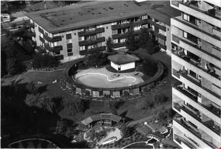
Falling Waters Apartment Building
https://search.heritageburnaby.ca/link/archivedescription79022
- Repository
- City of Burnaby Archives
- Date
- September 27, 1976
- Collection/Fonds
- Burnaby Public Library Contemporary Visual Archive Project
- Description Level
- Item
- Physical Description
- 1 photograph : b&w ; 11 x 16 cm mounted on cardboard
- Scope and Content
- Photograph shows the view from Salish Court Tower West of the swimming pool behind the Falling Waters apartment building on Cameron Street.
- Repository
- City of Burnaby Archives
- Date
- September 27, 1976
- Collection/Fonds
- Burnaby Public Library Contemporary Visual Archive Project
- Physical Description
- 1 photograph : b&w ; 11 x 16 cm mounted on cardboard
- Description Level
- Item
- Record No.
- 556-096
- Access Restriction
- No restrictions
- Reproduction Restriction
- Reproduce for fair dealing purposes only
- Accession Number
- 2013-13
- Scope and Content
- Photograph shows the view from Salish Court Tower West of the swimming pool behind the Falling Waters apartment building on Cameron Street.
- Subjects
- Buildings - Residential - Apartments
- Media Type
- Photograph
- Photographer
- Campbell, Peg
- Notes
- Scope note taken directly from BPL photograph description.
- 1 b&w copy negative : 10 x 12.5 cm accompanying
- Geographic Access
- Cameron Street
- Street Address
- 9444 Cameron Street
- Historic Neighbourhood
- Burquitlam (Historic Neighbourhood)
- Planning Study Area
- Cameron Area
Images