More like '6742 Walker Avenue demolition'
Narrow Results By
Decade
- 2020s 99
- 2010s 46
- 2000s 535
- 1990s 451
- 1980s 443
- 1970s
- 1960s 305
- 1950s 499
- 1940s
- 1930s 384
- 1920s 449
- 1910s 511
- 1900s 202
- 1890s 33
- 1880s 52
- 1870s 5
- 1860s 3
- 1850s 2
- 1840s 1
- 1830s 1
- 1820s 1
- 1810s 2
- 1800s 2
- 1790s 2
- 1780s 2
- 1770s 2
- 1760s 2
- 1750s 2
- 1740s 2
- 1730s 2
- 1720s 2
- 1710s 2
- 1700s 2
- 1690s 2
- 1680s 2
- 1670s 2
- 1660s 2
- 1650s 2
- 1640s 2
- 1630s 2
- 1620s 2
- 1610s 2
- 1600s 2
- 1590s 1
- 1580s 1
- 1570s 1
- 1560s 1
- 1550s 1
- 1540s 1
- 1530s 1
- 1520s 1
- 1510s 1
- 1500s 1
- 1490s 1
- 1480s 1
Subject
- Advertising Medium - Signs and Signboards 35
- Aerial Photographs 15
- Agricultural Tools and Equipment 5
- Agricultural Tools and Equipment - Cultivators 2
- Agricultural Tools and Equipment - Gardening Equipment 1
- Agricultural Tools and Equipment - Plows 1
- Agricultural Tools and Equipment - Tractors 1
- Agriculture - Farms 10
- Agriculture - Fruit and Berries 3
- Agriculture - Poultry 1
- Animals - Birds 1
- Animals - Cows 2

Capitol Hill Community Hall
https://search.heritageburnaby.ca/link/landmark563
- Repository
- Burnaby Heritage Planning
- Description
- Public building.
- Associated Dates
- 1948
- Street View URL
- Google Maps Street View
- Repository
- Burnaby Heritage Planning
- Geographic Access
- Howard Avenue
- Associated Dates
- 1948
- Description
- Public building.
- Heritage Value
- The Capitol Hill Community Hall was designed by local architect Harold Cullerne (1890-1976). After Cullerne returned from service during the First World War, he joined J.H. Bowman in a partnership that lasted from 1919 to 1934. After Bowman retired in 1934, Cullerne practiced on his own, continuing to work on schools and institutional buildings, such as the Art Deco Hollywood Theatre in Vancouver. In 1944, Cullerne designed a community hall for Capitol Hill; the scheme was delayed, and redesigned before it was finally built after the end of the Second World War. A simple front gabled roof hall structure, this hall is a monument to community spirit, erected by community members on a volunteer basis, and used for community events for over half a century. The hall replaced two earlier structures, both destroyed by fire, that had served the same purpose.
- Locality
- Capitol Hill
- Historic Neighbourhood
- Capitol Hill (Historic Neighbourhood)
- Planning Study Area
- Capitol Hill Area
- Architect
- Harold Cullerne
- Ownership
- Public (local)
- Street Address
- 361 Howard Avenue
- Street View URL
- Google Maps Street View
Images


Gilmore Avenue and Douglas Road
https://search.heritageburnaby.ca/link/archivedescription34112
- Repository
- City of Burnaby Archives
- Date
- March 27, 1947
- Collection/Fonds
- Burnaby Historical Society fonds
- Description Level
- Item
- Physical Description
- 1 photograph : b&w negative ; 6.8 x 11.6 cm
- Scope and Content
- Photograph of Gilmore Avenue and Douglas Road with a car parked at the side of the road and two men with surveying equipment. This is part of the Willingdon Heights subdivision site.
- Repository
- City of Burnaby Archives
- Date
- March 27, 1947
- Collection/Fonds
- Burnaby Historical Society fonds
- Subseries
- Alfred Bingham subseries
- Physical Description
- 1 photograph : b&w negative ; 6.8 x 11.6 cm
- Description Level
- Item
- Record No.
- 010-028
- Access Restriction
- No restrictions
- Reproduction Restriction
- No known restrictions
- Accession Number
- BHS2007-04
- Scope and Content
- Photograph of Gilmore Avenue and Douglas Road with a car parked at the side of the road and two men with surveying equipment. This is part of the Willingdon Heights subdivision site.
- Subjects
- Industries - Construction
- Buildings - Residential - Houses
- Construction Tools and Equipment
- Media Type
- Photograph
- Photographer
- Bingham, Alfred "Alf"
- Notes
- Title based on contents of photograph
- Geographic Access
- Gilmore Avenue
- Douglas Road
Images


London mixer and contractors
https://search.heritageburnaby.ca/link/archivedescription34138
- Repository
- City of Burnaby Archives
- Date
- April 16, 1947
- Collection/Fonds
- Burnaby Historical Society fonds
- Description Level
- Item
- Physical Description
- 1 photograph : b&w negative ; 6.8 x 11.8 cm
- Scope and Content
- Photograph of Gilmore Avenue and Douglas Road including a London mixer and contractors invovled in house construction. The man standing in the center has been identified as Mr. Marcowitz. This is part of the Willingdon Heights subdivision site.
- Repository
- City of Burnaby Archives
- Date
- April 16, 1947
- Collection/Fonds
- Burnaby Historical Society fonds
- Subseries
- Alfred Bingham subseries
- Physical Description
- 1 photograph : b&w negative ; 6.8 x 11.8 cm
- Description Level
- Item
- Record No.
- 010-054
- Access Restriction
- No restrictions
- Reproduction Restriction
- Reproduce for fair dealing purposes only
- Accession Number
- BHS2007-04
- Scope and Content
- Photograph of Gilmore Avenue and Douglas Road including a London mixer and contractors invovled in house construction. The man standing in the center has been identified as Mr. Marcowitz. This is part of the Willingdon Heights subdivision site.
- Subjects
- Occupations - Labourers
- Industries - Construction
- Construction Tools and Equipment
- Buildings - Residential - Houses
- Media Type
- Photograph
- Photographer
- Bingham, Alfred "Alf"
- Notes
- Title based on contents of photograph
- Geographic Access
- Gilmore Avenue
- Douglas Road
Images

![Two bulldozers, [194-] thumbnail](/media/hpo/_Data/_BVM_Images/1971/197100120076.jpg?width=280)
Two bulldozers
https://search.heritageburnaby.ca/link/museumdescription8
- Repository
- Burnaby Village Museum
- Date
- [194-]
- Collection/Fonds
- Burnaby Village Museum Photograph collection
- Description Level
- Item
- Physical Description
- 1 photograph : b&w ; 6.8 x 11.4 cm
- Scope and Content
- Photograph of two bulldozers, belonging to "Holmes & Wilson Trucking", clearing a lot beside a row of houses. Building materials (bricks and lumber) are piled nearby. This may be related to the construction of the Willingdon Heights subdivision. Stamp on back of photograph reads: "342x."
- Repository
- Burnaby Village Museum
- Collection/Fonds
- Burnaby Village Museum Photograph collection
- Description Level
- Item
- Physical Description
- 1 photograph : b&w ; 6.8 x 11.4 cm
- Scope and Content
- Photograph of two bulldozers, belonging to "Holmes & Wilson Trucking", clearing a lot beside a row of houses. Building materials (bricks and lumber) are piled nearby. This may be related to the construction of the Willingdon Heights subdivision. Stamp on back of photograph reads: "342x."
- Subjects
- Industries - Construction
- Buildings - Residential - Houses
- Construction Tools and Equipment
- Names
- Bingham, Alfred "Alf"
- Accession Code
- HV971.12.76
- Access Restriction
- No restrictions
- Reproduction Restriction
- No known restrictions
- Date
- [194-]
- Media Type
- Photograph
- Historic Neighbourhood
- Vancouver Heights (Historic Neighbourhood)
- Planning Study Area
- Willingdon Heights Area
- Scan Resolution
- 600
- Scan Date
- 2023-03-21
- Notes
- Title based on contents of photograph
Images
![Two bulldozers, [194-] thumbnail](/media/hpo/_Data/_BVM_Images/1971/197100120076.jpg)
Garage construction
https://search.heritageburnaby.ca/link/archivedescription51756
- Repository
- City of Burnaby Archives
- Date
- 1971
- Collection/Fonds
- Harold H. Johnston fonds
- Description Level
- Item
- Physical Description
- 1 photograph (jpeg) : b&w
- Scope and Content
- Photograph of two men working on a garage identified as belonging to Sean Pepere. Construction material and debris are visible around the worksite The photograph was most likely taken in the Venables Street area of Burnaby.
- Repository
- City of Burnaby Archives
- Date
- 1971
- Collection/Fonds
- Harold H. Johnston fonds
- Physical Description
- 1 photograph (jpeg) : b&w
- Description Level
- Item
- Record No.
- 483-084
- Access Restriction
- No restrictions
- Reproduction Restriction
- No reproduction permitted
- Accession Number
- 2008-08
- Scope and Content
- Photograph of two men working on a garage identified as belonging to Sean Pepere. Construction material and debris are visible around the worksite The photograph was most likely taken in the Venables Street area of Burnaby.
- Media Type
- Photograph
- Photographer
- Johnston, Harold H.
- Notes
- Title based on contents of photograph
- Geographic Access
- Venables Street
- Historic Neighbourhood
- Vancouver Heights (Historic Neighbourhood)
- Planning Study Area
- Willingdon Heights Area
Images

Land clearing machines
https://search.heritageburnaby.ca/link/archivedescription34108
- Repository
- City of Burnaby Archives
- Date
- March 16, 1947
- Collection/Fonds
- Burnaby Historical Society fonds
- Description Level
- Item
- Physical Description
- 1 photograph : b&w negative ; 6.8 x 11.4 cm
- Scope and Content
- Photograph of land clearing machines at 4124 Napier Street. Partially constructed houses and lumber are visible, and a sign on the side of a bulldozer reads "Holmes and Wilson Trucking." This is part of the Willingdon Heights subdivision site.
- Repository
- City of Burnaby Archives
- Date
- March 16, 1947
- Collection/Fonds
- Burnaby Historical Society fonds
- Subseries
- Alfred Bingham subseries
- Physical Description
- 1 photograph : b&w negative ; 6.8 x 11.4 cm
- Description Level
- Item
- Record No.
- 010-024
- Access Restriction
- No restrictions
- Reproduction Restriction
- No known restrictions
- Accession Number
- BHS2007-04
- Scope and Content
- Photograph of land clearing machines at 4124 Napier Street. Partially constructed houses and lumber are visible, and a sign on the side of a bulldozer reads "Holmes and Wilson Trucking." This is part of the Willingdon Heights subdivision site.
- Media Type
- Photograph
- Photographer
- Bingham, Alfred "Alf"
- Notes
- Title based on contents of photograph
- Geographic Access
- Napier Street
- Street Address
- 4124 Napier Street
Images


Madison Avenue and Kitchener Street
https://search.heritageburnaby.ca/link/archivedescription34240
- Repository
- City of Burnaby Archives
- Date
- August 20, 1947
- Collection/Fonds
- Burnaby Historical Society fonds
- Description Level
- Item
- Physical Description
- 1 photograph : b&w negative ; 6.8 x 13.1 cm
- Scope and Content
- Photograph of the 4200 block of Kitchener Street at Madison Avenue with cleared land and brush in foreground, and a bulldozer, lumber and houses under construction in background. This is part of the Willingdon Heights subdivision site.
- Repository
- City of Burnaby Archives
- Date
- August 20, 1947
- Collection/Fonds
- Burnaby Historical Society fonds
- Subseries
- Alfred Bingham subseries
- Physical Description
- 1 photograph : b&w negative ; 6.8 x 13.1 cm
- Description Level
- Item
- Record No.
- 010-152
- Access Restriction
- No restrictions
- Reproduction Restriction
- No known restrictions
- Accession Number
- BHS2007-04
- Scope and Content
- Photograph of the 4200 block of Kitchener Street at Madison Avenue with cleared land and brush in foreground, and a bulldozer, lumber and houses under construction in background. This is part of the Willingdon Heights subdivision site.
- Media Type
- Photograph
- Photographer
- Bingham, Alfred "Alf"
- Notes
- Title based on contents of photograph
- Geographic Access
- Kitchener Street
Images


Cabin
https://search.heritageburnaby.ca/link/museumdescription13061
- Repository
- Burnaby Village Museum
- Date
- 1973 (date of original), digitized in 2020
- Collection/Fonds
- Burnaby Village Museum Film and Video collection
- Description Level
- Item
- Physical Description
- 1 film reel (22 min., 22 sec.) : 24 fps, polyester, positive, col., sd. ; 16 mm
- Scope and Content
- Item consists of a film titled "Cabin" that is produced and directed by James Bizzochi. The film documents the building of a log cabin using pioneer tools. The building takes place at Heritage Village (now Burnaby Village Museum) and includes a commentary by the craftsman, Earl Carter. Opening foot…
- Repository
- Burnaby Village Museum
- Collection/Fonds
- Burnaby Village Museum Film and Video collection
- Description Level
- Item
- Physical Description
- 1 film reel (22 min., 22 sec.) : 24 fps, polyester, positive, col., sd. ; 16 mm
- Material Details
- Producer and Director - James Bizzocchi
- Cabin building and narration - Earl Carter
- Editing- Justine Dancy
- Director of Cinematography - Selwyn Pullan
- Music- Ralph Dyck
- Titles - Carl Chaplin
- Scope and Content
- Item consists of a film titled "Cabin" that is produced and directed by James Bizzochi. The film documents the building of a log cabin using pioneer tools. The building takes place at Heritage Village (now Burnaby Village Museum) and includes a commentary by the craftsman, Earl Carter. Opening footage includes historic photographs from the Vancouver Public Library Photographic collection.
- History
- Film director and producer James (Jim) Bizzochi is a moving image artist living and working in British Columbia. Jim created the film while working as a professor with Simon Fraser University. Cinematographer Selwyn Pullan is a distinguised Canadian photographer who specialized in building photography documenting B.C. mid-century modernism.
- Publisher
- Copyright 1973, Jim Bizzocchi. All rights reserved,
- Other Title Information
- Copyright 1973, Jim Bizzocchi. All rights reserved,
- Subjects
- Buildings - Civic - Museums
- Buildings - Residential - Cabins
- Construction
- Construction Tools and Equipment
- Names
- Carter, Earl
- Bizzocchi, James
- Pullan, Selwyn
- Chaplin, Carl
- Dancy, Justine
- Dyck, Ralph
- Burnaby Village Museum
- Accession Code
- BV020.5.709
- Access Restriction
- Restricted access
- Reproduction Restriction
- May be restricted by third party rights
- Date
- 1973 (date of original), digitized in 2020
- Media Type
- Moving Images
- Photographer
- Pullan, Selwyn
- Notes
- Transcribed title
- Copyright MCMLXXIII
- Film under copyright - for Fair Dealing Purposes only
- End Credits : "Thanks to / Heritage Village Museum - Burnaby / Simon Fraser University Film Workshop / Vancouver Public Library Photographic Collection"
Images

Video
Cabin, 1973 (date of original), digitized in 2020
Cabin, 1973 (date of original), digitized in 2020
https://search.heritageburnaby.ca/media/hpo/_Data/_BVM_Moving_Images/2020_0005_0709_001.mp4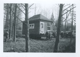
Irvine house being installed
https://search.heritageburnaby.ca/link/museumdescription1877
- Repository
- Burnaby Village Museum
- Date
- April 6, 1975
- Collection/Fonds
- Century Park Museum Association fonds
- Description Level
- Item
- Physical Description
- 1 photograph : b&w ; 7 x 10 cm
- Scope and Content
- Photograph of Tom Irvine's house during its installation at Heritage Village (now the Burnaby Village Museum). Men surround the house as it sits on a gooseneck trailer stationed inside a fence.
- Repository
- Burnaby Village Museum
- Collection/Fonds
- Century Park Museum Association fonds
- Description Level
- Item
- Physical Description
- 1 photograph : b&w ; 7 x 10 cm
- Scope and Content
- Photograph of Tom Irvine's house during its installation at Heritage Village (now the Burnaby Village Museum). Men surround the house as it sits on a gooseneck trailer stationed inside a fence.
- Geographic Access
- Deer Lake Drive
- Accession Code
- BV005.14.31
- Access Restriction
- Restricted access
- Reproduction Restriction
- May be restricted by third party rights
- Date
- April 6, 1975
- Media Type
- Photograph
- Scan Resolution
- 600
- Scan Date
- 11-Jun-09
- Scale
- 100
- Notes
- Title based on contents of photograph
- Note in pencil on verso of photograph reads: "April/75"
Images

Irvine house being installed
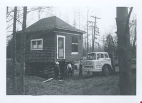
https://search.heritageburnaby.ca/link/museumdescription1878
- Repository
- Burnaby Village Museum
- Date
- April 6, 1975
- Collection/Fonds
- Century Park Museum Association fonds
- Description Level
- Item
- Physical Description
- 1 photograph : b&w ; 7 x 10 cm
- Scope and Content
- Photograph of Tom Irvine's house during its installation at Heritage Village (now the Burnaby Village Museum). The house is raised on a cribbing and surrounded by workmen. A truck parked next to it has a sign that reads, "L.W. ZEBIAK HOUSE RAISING COMPLETE BASEMENTS."
- Repository
- Burnaby Village Museum
- Collection/Fonds
- Century Park Museum Association fonds
- Description Level
- Item
- Physical Description
- 1 photograph : b&w ; 7 x 10 cm
- Scope and Content
- Photograph of Tom Irvine's house during its installation at Heritage Village (now the Burnaby Village Museum). The house is raised on a cribbing and surrounded by workmen. A truck parked next to it has a sign that reads, "L.W. ZEBIAK HOUSE RAISING COMPLETE BASEMENTS."
- Subjects
- Buildings - Residential - Houses
- Tools and Equipment
- Transportation - Trucks
- Occupations - Labourers
- Geographic Access
- Deer Lake Drive
- Accession Code
- BV005.14.32
- Access Restriction
- Restricted access
- Reproduction Restriction
- May be restricted by third party rights
- Date
- April 6, 1975
- Media Type
- Photograph
- Scan Resolution
- 600
- Scan Date
- 11-Jun-09
- Scale
- 100
- Notes
- Title based on contents of photograph
- Note in pencil on verso of photograph reads: "April/75"
Images
Irvine house being installed
https://search.heritageburnaby.ca/link/museumdescription1880
- Repository
- Burnaby Village Museum
- Date
- April 6, 1975
- Collection/Fonds
- Century Park Museum Association fonds
- Description Level
- Item
- Physical Description
- 1 photograph : b&w ; 7 x 10 cm
- Scope and Content
- Photograph of Tom Irvine's house during its installation at Heritage Village (now the Burnaby Village Museum). Three people are visible at the basement side entrance looking in. The house's foundation is made of horizontal wood planks and there is a pile of lumber visible in the foreground.
- Repository
- Burnaby Village Museum
- Collection/Fonds
- Century Park Museum Association fonds
- Description Level
- Item
- Physical Description
- 1 photograph : b&w ; 7 x 10 cm
- Scope and Content
- Photograph of Tom Irvine's house during its installation at Heritage Village (now the Burnaby Village Museum). Three people are visible at the basement side entrance looking in. The house's foundation is made of horizontal wood planks and there is a pile of lumber visible in the foreground.
- Geographic Access
- Deer Lake Drive
- Accession Code
- BV005.14.34
- Access Restriction
- Restricted access
- Reproduction Restriction
- May be restricted by third party rights
- Date
- April 6, 1975
- Media Type
- Photograph
- Scan Resolution
- 600
- Scan Date
- 11-Jun-09
- Scale
- 100
- Notes
- Title based on contents of photograph
- Note in pencil on verso of photograph reads: "April/75"
Images

Construction site
https://search.heritageburnaby.ca/link/archivedescription34215
- Repository
- City of Burnaby Archives
- Date
- June 29, 1947
- Collection/Fonds
- Burnaby Historical Society fonds
- Description Level
- Item
- Physical Description
- 1 photograph : b&w negative ; 6.8 x 11.2 cm
- Scope and Content
- Photograph of five men standing outside at a construction site. Buildings, houses and lumber can be seen in the background. This is part of the Willingdon Heights subdivision site.
- Repository
- City of Burnaby Archives
- Date
- June 29, 1947
- Collection/Fonds
- Burnaby Historical Society fonds
- Subseries
- Alfred Bingham subseries
- Physical Description
- 1 photograph : b&w negative ; 6.8 x 11.2 cm
- Description Level
- Item
- Record No.
- 010-131
- Access Restriction
- No restrictions
- Reproduction Restriction
- Reproduce for fair dealing purposes only
- Accession Number
- BHS2007-04
- Scope and Content
- Photograph of five men standing outside at a construction site. Buildings, houses and lumber can be seen in the background. This is part of the Willingdon Heights subdivision site.
- Media Type
- Photograph
- Photographer
- Bingham, Alfred "Alf"
- Notes
- Title based on contents of photograph
Images
![Real Estate - Surveyor's office building, [1977] thumbnail](/media/hpo/_Data/_BVM_Images/2020/2020_0005_1513_001.jpg?width=280)
Real Estate - Surveyor's office building
https://search.heritageburnaby.ca/link/museumdescription14685
- Repository
- Burnaby Village Museum
- Date
- [1977]
- Collection/Fonds
- Century Park Museum Association fonds
- Description Level
- Item
- Physical Description
- 1 photograph : col. slide ; 35 mm
- Scope and Content
- Photograph of the Real Estate Office and Surveyor's building on top of a flatbed truck trailer with jacks and wood cribbing piles at the end. The Royal Bank building is visible to the left.
- Repository
- Burnaby Village Museum
- Collection/Fonds
- Century Park Museum Association fonds
- Description Level
- Item
- Physical Description
- 1 photograph : col. slide ; 35 mm
- Scope and Content
- Photograph of the Real Estate Office and Surveyor's building on top of a flatbed truck trailer with jacks and wood cribbing piles at the end. The Royal Bank building is visible to the left.
- History
- The building was originally located at 3043 (pre-1958) / 6108 Patterson Avenue, Lot 22, Block 33, District Lot 151, Plan 2002. It was built ca. 1929, possibly by Mr. Cuthbert Pratt. Over the years it was used as a confectionary store, grocery store, home, and small boarding house. By 1977, it was operating as the Magee Grocery Store. The building was moved to BVM in May 1977 and then adapted to look like the original Dow, Fraser & Co. Ltd. real estate building.
- Names
- Burnaby Village Museum
- Accession Code
- BV020.5.1513
- Access Restriction
- No restrictions
- Reproduction Restriction
- No known restrictions
- Date
- [1977]
- Media Type
- Photograph
- Scan Resolution
- 2400
- Scan Date
- 17-Nov-2020
- Scale
- 100
- Notes
- Title based on contents of photograph
Images
![Real Estate - Surveyor's office building, [1977] thumbnail](/media/hpo/_Data/_BVM_Images/2020/2020_0005_1513_001.jpg)
![Real Estate - Surveyor's office building, [1977] thumbnail](/media/hpo/_Data/_BVM_Images/2020/2020_0005_1514_001.jpg?width=280)
Real Estate - Surveyor's office building
https://search.heritageburnaby.ca/link/museumdescription14686
- Repository
- Burnaby Village Museum
- Date
- [1977]
- Collection/Fonds
- Century Park Museum Association fonds
- Description Level
- Item
- Physical Description
- 1 photograph : col. slide ; 35 mm
- Scope and Content
- Photograph of the Real Estate Office and Surveyor's building on top of a flatbed truck trailer. A man is visible crouching underneath next to a cribbing pile.
- Repository
- Burnaby Village Museum
- Collection/Fonds
- Century Park Museum Association fonds
- Description Level
- Item
- Physical Description
- 1 photograph : col. slide ; 35 mm
- Scope and Content
- Photograph of the Real Estate Office and Surveyor's building on top of a flatbed truck trailer. A man is visible crouching underneath next to a cribbing pile.
- History
- The building was originally located at 3043 (pre-1958) / 6108 Patterson Avenue, Lot 22, Block 33, District Lot 151, Plan 2002. It was built ca. 1929, possibly by Mr. Cuthbert Pratt. Over the years it was used as a confectionary store, grocery store, home, and small boarding house. By 1977, it was operating as the Magee Grocery Store. The building was moved to BVM in May 1977 and then adapted to look like the original Dow, Fraser & Co. Ltd. real estate building.
- Names
- Burnaby Village Museum
- Accession Code
- BV020.5.1514
- Access Restriction
- No restrictions
- Reproduction Restriction
- No known restrictions
- Date
- [1977]
- Media Type
- Photograph
- Scan Resolution
- 2400
- Scan Date
- 17-Nov-2020
- Scale
- 100
- Notes
- Title based on contents of photograph
Images
![Real Estate - Surveyor's office building, [1977] thumbnail](/media/hpo/_Data/_BVM_Images/2020/2020_0005_1514_001.jpg)
![202 Delta Avenue under construction, [1948] (date of original), copied 1991 thumbnail](/media/hpo/_Data/_Archives_Images/_Unrestricted/370/370-226.jpg?width=280)
202 Delta Avenue under construction
https://search.heritageburnaby.ca/link/archivedescription37638
- Repository
- City of Burnaby Archives
- Date
- [1948] (date of original), copied 1991
- Collection/Fonds
- Burnaby Historical Society fonds
- Description Level
- Item
- Physical Description
- 1 photograph : b&w ; 3.2 x 5.3 cm print on contact sheet 20.2 x 25.3 cm
- Scope and Content
- Photograph of the house at 202 Delta Avenue under construction.
- Repository
- City of Burnaby Archives
- Date
- [1948] (date of original), copied 1991
- Collection/Fonds
- Burnaby Historical Society fonds
- Subseries
- Burnaby Image Bank subseries
- Physical Description
- 1 photograph : b&w ; 3.2 x 5.3 cm print on contact sheet 20.2 x 25.3 cm
- Description Level
- Item
- Record No.
- 370-226
- Access Restriction
- No restrictions
- Reproduction Restriction
- No known restrictions
- Accession Number
- BHS1999-03
- Scope and Content
- Photograph of the house at 202 Delta Avenue under construction.
- Media Type
- Photograph
- Notes
- Title based on contents of photograph
- 1 b&w copy negative accompanying
- Geographic Access
- Delta Avenue
- Street Address
- 202 Delta Avenue
- Historic Neighbourhood
- Capitol Hill (Historic Neighbourhood)
- Planning Study Area
- Capitol Hill Area
Images
![202 Delta Avenue under construction, [1948] (date of original), copied 1991 thumbnail](/media/hpo/_Data/_Archives_Images/_Unrestricted/370/370-226.jpg)
![202 Delta Avenue under construction, [1949] (date of original), copied 1991 thumbnail](/media/hpo/_Data/_Archives_Images/_Unrestricted/370/370-227.jpg?width=280)
202 Delta Avenue under construction
https://search.heritageburnaby.ca/link/archivedescription37639
- Repository
- City of Burnaby Archives
- Date
- [1949] (date of original), copied 1991
- Collection/Fonds
- Burnaby Historical Society fonds
- Description Level
- Item
- Physical Description
- 1 photograph : b&w ; 3.2 x 5.3 cm print on contact sheet 20.2 x 25.3 cm
- Scope and Content
- Photograph of the house at 202 Delta Avenue under construction.
- Repository
- City of Burnaby Archives
- Date
- [1949] (date of original), copied 1991
- Collection/Fonds
- Burnaby Historical Society fonds
- Subseries
- Burnaby Image Bank subseries
- Physical Description
- 1 photograph : b&w ; 3.2 x 5.3 cm print on contact sheet 20.2 x 25.3 cm
- Description Level
- Item
- Record No.
- 370-227
- Access Restriction
- No restrictions
- Reproduction Restriction
- No restrictions
- Accession Number
- BHS1999-03
- Scope and Content
- Photograph of the house at 202 Delta Avenue under construction.
- Media Type
- Photograph
- Notes
- Title based on contents of photograph
- 1 b&w copy negative accompanying
- Geographic Access
- Delta Avenue
- Street Address
- 202 Delta Avenue
- Historic Neighbourhood
- Capitol Hill (Historic Neighbourhood)
- Planning Study Area
- Capitol Hill Area
Images
![202 Delta Avenue under construction, [1949] (date of original), copied 1991 thumbnail](/media/hpo/_Data/_Archives_Images/_Unrestricted/370/370-227.jpg)
![5165 Sperling Avenue construction, [1941 or 1942] (date of original), copied 1991 thumbnail](/media/hpo/_Data/_Archives_Images/_Unrestricted/370/370-550.jpg?width=280)
5165 Sperling Avenue construction
https://search.heritageburnaby.ca/link/archivedescription37963
- Repository
- City of Burnaby Archives
- Date
- [1941 or 1942] (date of original), copied 1991
- Collection/Fonds
- Burnaby Historical Society fonds
- Description Level
- Item
- Physical Description
- 1 photograph : b&w ; 2.6 x 3.7 cm print on contact sheet 20.7 x 26.2 cm
- Scope and Content
- Photograph of the house of the Montague Moore family under construction at 5165 Sperling Avenue.
- Repository
- City of Burnaby Archives
- Date
- [1941 or 1942] (date of original), copied 1991
- Collection/Fonds
- Burnaby Historical Society fonds
- Subseries
- Burnaby Image Bank subseries
- Physical Description
- 1 photograph : b&w ; 2.6 x 3.7 cm print on contact sheet 20.7 x 26.2 cm
- Description Level
- Item
- Record No.
- 370-550
- Access Restriction
- No restrictions
- Reproduction Restriction
- No known restrictions
- Accession Number
- BHS1999-03
- Scope and Content
- Photograph of the house of the Montague Moore family under construction at 5165 Sperling Avenue.
- Media Type
- Photograph
- Notes
- Title based on contents of photograph
- 1 b&w copy negative accompanying
- Geographic Access
- Sperling Avenue
- Street Address
- 5165 Sperling Avenue
- Historic Neighbourhood
- Burnaby Lake (Historic Neighbourhood)
- Planning Study Area
- Morley-Buckingham Area
Images
![5165 Sperling Avenue construction, [1941 or 1942] (date of original), copied 1991 thumbnail](/media/hpo/_Data/_Archives_Images/_Unrestricted/370/370-550.jpg)
![5165 Sperling Avenue construction, [1941 or 1942] (date of original), copied 1991 thumbnail](/media/hpo/_Data/_Archives_Images/_Unrestricted/370/370-551.jpg?width=280)
5165 Sperling Avenue construction
https://search.heritageburnaby.ca/link/archivedescription37964
- Repository
- City of Burnaby Archives
- Date
- [1941 or 1942] (date of original), copied 1991
- Collection/Fonds
- Burnaby Historical Society fonds
- Description Level
- Item
- Physical Description
- 1 photograph : b&w ; 2.6 x 3.7 cm print on contact sheet 20.7 x 26.2 cm
- Scope and Content
- Photograph of the house of the Montague Moore family under construction at 5165 Sperling Avenue. Other houses on the street can be seen to the right, and the road can be seen in the foreground.
- Repository
- City of Burnaby Archives
- Date
- [1941 or 1942] (date of original), copied 1991
- Collection/Fonds
- Burnaby Historical Society fonds
- Subseries
- Burnaby Image Bank subseries
- Physical Description
- 1 photograph : b&w ; 2.6 x 3.7 cm print on contact sheet 20.7 x 26.2 cm
- Description Level
- Item
- Record No.
- 370-551
- Access Restriction
- No restrictions
- Reproduction Restriction
- No known restrictions
- Accession Number
- BHS1999-03
- Scope and Content
- Photograph of the house of the Montague Moore family under construction at 5165 Sperling Avenue. Other houses on the street can be seen to the right, and the road can be seen in the foreground.
- Media Type
- Photograph
- Notes
- Title based on contents of photograph
- 1 b&w copy negative accompanying
- Geographic Access
- Sperling Avenue
- Street Address
- 5165 Sperling Avenue
- Historic Neighbourhood
- Burnaby Lake (Historic Neighbourhood)
- Planning Study Area
- Morley-Buckingham Area
Images
![5165 Sperling Avenue construction, [1941 or 1942] (date of original), copied 1991 thumbnail](/media/hpo/_Data/_Archives_Images/_Unrestricted/370/370-551.jpg)
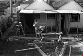
![6113 Silver Avenue addition, [1947] (date of original), copied 1991 thumbnail](/media/hpo/_Data/_Archives_Images/_Unrestricted/370/370-367.jpg?width=280)
6113 Silver Avenue addition
https://search.heritageburnaby.ca/link/archivedescription37779
- Repository
- City of Burnaby Archives
- Date
- [1947] (date of original), copied 1991
- Collection/Fonds
- Burnaby Historical Society fonds
- Description Level
- Item
- Physical Description
- 1 photograph : b&w ; 2.5 x 3.6 cm print on contact sheet 20.3 x 26.2 cm
- Scope and Content
- Photograph of the construction of an addition to 6113 Silver Avenue, the Ellis family home. Three people are sitting on the roof of the house.
- Repository
- City of Burnaby Archives
- Date
- [1947] (date of original), copied 1991
- Collection/Fonds
- Burnaby Historical Society fonds
- Subseries
- Burnaby Image Bank subseries
- Physical Description
- 1 photograph : b&w ; 2.5 x 3.6 cm print on contact sheet 20.3 x 26.2 cm
- Description Level
- Item
- Record No.
- 370-367
- Access Restriction
- No restrictions
- Reproduction Restriction
- No known restrictions
- Accession Number
- BHS1999-03
- Scope and Content
- Photograph of the construction of an addition to 6113 Silver Avenue, the Ellis family home. Three people are sitting on the roof of the house.
- Media Type
- Photograph
- Notes
- Title based on contents of photograph
- 1 b&w copy negative accompanying
- Negative has a pink cast
- Geographic Access
- Silver Avenue
- Street Address
- 6113 Silver Avenue
- Historic Neighbourhood
- Central Park (Historic Neighbourhood)
- Planning Study Area
- Maywood Area
Images
![6113 Silver Avenue addition, [1947] (date of original), copied 1991 thumbnail](/media/hpo/_Data/_Archives_Images/_Unrestricted/370/370-367.jpg)
![6113 Silver Avenue addition, [1947] (date of original), copied 1991 thumbnail](/media/hpo/_Data/_Archives_Images/_Unrestricted/370/370-368.jpg?width=280)
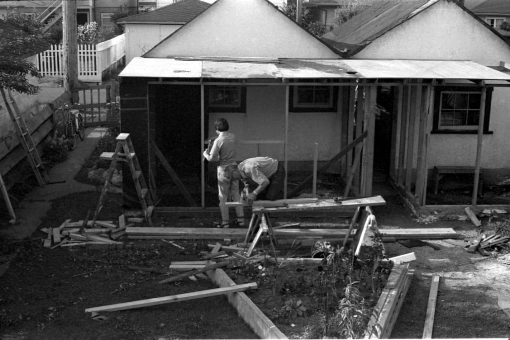
6113 Silver Avenue addition
https://search.heritageburnaby.ca/link/archivedescription37780
- Repository
- City of Burnaby Archives
- Date
- [1947] (date of original), copied 1991
- Collection/Fonds
- Burnaby Historical Society fonds
- Description Level
- Item
- Physical Description
- 1 photograph : b&w ; 2.5 x 3.6 cm print on contact sheet 20.3 x 26.2 cm
- Scope and Content
- Photograpm of the completed construction of an addition to 6113 Silver Avenue, the Ellis family home. Another house and car can be seen to the left.
- Repository
- City of Burnaby Archives
- Date
- [1947] (date of original), copied 1991
- Collection/Fonds
- Burnaby Historical Society fonds
- Subseries
- Burnaby Image Bank subseries
- Physical Description
- 1 photograph : b&w ; 2.5 x 3.6 cm print on contact sheet 20.3 x 26.2 cm
- Description Level
- Item
- Record No.
- 370-368
- Access Restriction
- No restrictions
- Reproduction Restriction
- No known restrictions
- Accession Number
- BHS1999-03
- Scope and Content
- Photograpm of the completed construction of an addition to 6113 Silver Avenue, the Ellis family home. Another house and car can be seen to the left.
- Media Type
- Photograph
- Notes
- Title based on contents of photograph
- 1 b&w copy negative accompanying
- Negative has a pink cast
- Geographic Access
- Silver Avenue
- Street Address
- 6113 Silver Avenue
- Historic Neighbourhood
- Central Park (Historic Neighbourhood)
- Planning Study Area
- Maywood Area
Images
![6113 Silver Avenue addition, [1947] (date of original), copied 1991 thumbnail](/media/hpo/_Data/_Archives_Images/_Unrestricted/370/370-368.jpg)