Narrow Results By
Subject
- Aerial Photographs 5
- Buildings - Civic - Hospitals 7
- Buildings - Civic - Libraries 2
- Buildings - Commercial - Grocery Stores 1
- Buildings - Religious - Churches 1
- Buildings - Residential - Houses 2
- Buildings - Schools 2
- Clothing - Uniforms 2
- Construction - Road Construction 2
- Geographic Features - Mountains 1
- Natural Phenomena - Snow 1
- Occupations - Civic Workers 2
Person / Organization
- AJ Equipment and Rentals Ltd. 1
- Armstrong Avenue School 3
- Bacon, Bryan 1
- British Columbia Electric Railway Company 1
- Burnaby Public Library 1
- Cariboo Hill Grocery 1
- Crest Shopping Centre 2
- George Derby Health Centre 9
- Hunter, Beatrice "Bea" Carpenter 2
- Korean Baptist Church 1
- Prittie, Robert W. "Bob" 1
Aerial photograph of Burnaby
https://search.heritageburnaby.ca/link/archivedescription84911
- Repository
- City of Burnaby Archives
- Date
- 1963
- Collection/Fonds
- Allan Amundsen collection
- Description Level
- Item
- Physical Description
- 1 photograph : b&w ; 22.5 x 22.5 cm
- Scope and Content
- Aerial photograph of Burnaby with Lougheed Highway running west to east through the middle of the photograph and the Trans Canada Highway in the lower left segment.
- Repository
- City of Burnaby Archives
- Date
- 1963
- Collection/Fonds
- Allan Amundsen collection
- Physical Description
- 1 photograph : b&w ; 22.5 x 22.5 cm
- Description Level
- Item
- Record No.
- 561-029
- Access Restriction
- In Archives only
- Reproduction Restriction
- No reproduction permitted
- Accession Number
- 2014-08
- Scope and Content
- Aerial photograph of Burnaby with Lougheed Highway running west to east through the middle of the photograph and the Trans Canada Highway in the lower left segment.
- Subjects
- Aerial Photographs
- Media Type
- Photograph
- Photographer
- Province of British Columbia
- Notes
- Title based on contents of photograph
- This photo is indentified as BC5062:22 and connects with B.C. air photograph BC5062:23 to the west and B.C. air photograph BC5062:21
- Historic Neighbourhood
- Lozells (Historic Neighbourhood)
- Burquitlam (Historic Neighbourhood)
- Planning Study Area
- Lake City Area
- Government Road Area
- Burnaby Lake Area
- Lyndhurst Area
- Cariboo-Armstrong Area
Aerial photograph of Burnaby
https://search.heritageburnaby.ca/link/archivedescription84913
- Repository
- City of Burnaby Archives
- Date
- 1963
- Collection/Fonds
- Allan Amundsen collection
- Description Level
- Item
- Physical Description
- 1 photograph : b&w ; 22.5 x 22.5 cm
- Scope and Content
- Aerial photograph of East Burnaby up to North Road and south of the Trans Canada Highway.
- Repository
- City of Burnaby Archives
- Date
- 1963
- Collection/Fonds
- Allan Amundsen collection
- Physical Description
- 1 photograph : b&w ; 22.5 x 22.5 cm
- Description Level
- Item
- Record No.
- 561-031
- Access Restriction
- In Archives only
- Reproduction Restriction
- No reproduction permitted
- Accession Number
- 2014-08
- Scope and Content
- Aerial photograph of East Burnaby up to North Road and south of the Trans Canada Highway.
- Subjects
- Aerial Photographs
- Media Type
- Photograph
- Photographer
- Province of British Columbia
- Notes
- Title based on contents of photograph
- This photo is indentified as BC5062:70 and connects with B.C. air photograph BC5062:21 to the west and BC5062:71 to the east
- Historic Neighbourhood
- East Burnaby (Historic Neighbourhood)
- Planning Study Area
- Cameron Area
- Cariboo-Armstrong Area
Aerial photograph of Burnaby and Coquitlam
https://search.heritageburnaby.ca/link/archivedescription84912
- Repository
- City of Burnaby Archives
- Date
- 1963
- Collection/Fonds
- Allan Amundsen collection
- Description Level
- Item
- Physical Description
- 1 photograph : b&w ; 22.5 x 22.5 cm
- Scope and Content
- Aerial photograph of Burnaby and Coquitlam with North Road running through the centre.
- Repository
- City of Burnaby Archives
- Date
- 1963
- Collection/Fonds
- Allan Amundsen collection
- Physical Description
- 1 photograph : b&w ; 22.5 x 22.5 cm
- Description Level
- Item
- Record No.
- 561-030
- Access Restriction
- In Archives only
- Reproduction Restriction
- No reproduction permitted
- Accession Number
- 2014-08
- Scope and Content
- Aerial photograph of Burnaby and Coquitlam with North Road running through the centre.
- Subjects
- Aerial Photographs
- Media Type
- Photograph
- Photographer
- Province of British Columbia
- Notes
- Title based on contents of photograph
- This photo is indentified as BC5062:21 and connects with B.C. air photograph BC5062:22 to the west and BC5062:70 to the east
- Historic Neighbourhood
- Burquitlam (Historic Neighbourhood)
- Planning Study Area
- Cameron Area
- Lyndhurst Area
- Cariboo-Armstrong Area
Aerial photograph of Burnaby and Coquitlam
https://search.heritageburnaby.ca/link/archivedescription84914
- Repository
- City of Burnaby Archives
- Date
- 1963
- Collection/Fonds
- Allan Amundsen collection
- Description Level
- Item
- Physical Description
- 1 photograph : b&w ; 22.5 x 22.5 cm
- Scope and Content
- Aerial photograph of East Burnaby and Coquitlam with North Road running through the centre.
- Repository
- City of Burnaby Archives
- Date
- 1963
- Collection/Fonds
- Allan Amundsen collection
- Physical Description
- 1 photograph : b&w ; 22.5 x 22.5 cm
- Description Level
- Item
- Record No.
- 561-032
- Access Restriction
- In Archives only
- Reproduction Restriction
- No reproduction permitted
- Accession Number
- 2014-08
- Scope and Content
- Aerial photograph of East Burnaby and Coquitlam with North Road running through the centre.
- Subjects
- Aerial Photographs
- Media Type
- Photograph
- Photographer
- Province of British Columbia
- Notes
- Title based on contents of photograph
- This photo is indentified as BC5062:71 and connects with B.C. air photograph BC5062:70 to the west
- Historic Neighbourhood
- East Burnaby (Historic Neighbourhood)
- Planning Study Area
- Cameron Area
- Cariboo-Armstrong Area

AJ Equipment and Rentals Ltd.
https://search.heritageburnaby.ca/link/archivedescription79207
- Repository
- City of Burnaby Archives
- Date
- October, 1976
- Collection/Fonds
- Burnaby Public Library Contemporary Visual Archive Project
- Description Level
- Item
- Physical Description
- 1 photograph : b&w ; 11 x 16 cm mounted on cardboard
- Scope and Content
- Photograph shows AJ Equipment and Rentals Ltd. - a garden centre and rental centre - at 8669 10th Avenue in the Crest Shopping Centre.
- Repository
- City of Burnaby Archives
- Date
- October, 1976
- Collection/Fonds
- Burnaby Public Library Contemporary Visual Archive Project
- Physical Description
- 1 photograph : b&w ; 11 x 16 cm mounted on cardboard
- Description Level
- Item
- Record No.
- 556-207
- Access Restriction
- No restrictions
- Reproduction Restriction
- Reproduce for fair dealing purposes only
- Accession Number
- 2013-13
- Scope and Content
- Photograph shows AJ Equipment and Rentals Ltd. - a garden centre and rental centre - at 8669 10th Avenue in the Crest Shopping Centre.
- Media Type
- Photograph
- Photographer
- Salmon, Stu
- Notes
- Scope note taken directly from BPL photograph description.
- 1 b&w copy negative : 10 x 12.5 cm accompanying
- Geographic Access
- 10th Avenue
- Street Address
- 8669 10th Avenue
- Historic Neighbourhood
- East Burnaby (Historic Neighbourhood)
- Planning Study Area
- Cariboo-Armstrong Area
Images


Armstrong Avenue Baptist Church
https://search.heritageburnaby.ca/link/archivedescription79054
- Repository
- City of Burnaby Archives
- Date
- October, 1976
- Collection/Fonds
- Burnaby Public Library Contemporary Visual Archive Project
- Description Level
- Item
- Physical Description
- 1 photograph : b&w ; 11 x 16 cm mounted on cardboard
- Scope and Content
- Photograph shows the Armstrong Avenue Baptist Church at 8585 Armstrong Avenue. At the time of the photograph it was also the Korean Baptist Church.
- Repository
- City of Burnaby Archives
- Date
- October, 1976
- Collection/Fonds
- Burnaby Public Library Contemporary Visual Archive Project
- Physical Description
- 1 photograph : b&w ; 11 x 16 cm mounted on cardboard
- Description Level
- Item
- Record No.
- 556-120
- Access Restriction
- No restrictions
- Reproduction Restriction
- Reproduce for fair dealing purposes only
- Accession Number
- 2013-13
- Scope and Content
- Photograph shows the Armstrong Avenue Baptist Church at 8585 Armstrong Avenue. At the time of the photograph it was also the Korean Baptist Church.
- Subjects
- Buildings - Religious - Churches
- Names
- Korean Baptist Church
- Media Type
- Photograph
- Photographer
- Salmon, Stu
- Notes
- Scope note taken directly from BPL photograph description.
- 1 b&w copy negative : 10 x 12.5 cm accompanying
- Geographic Access
- Armstrong Avenue
- Street Address
- 8585 Armstrong Avenue
- Historic Neighbourhood
- East Burnaby (Historic Neighbourhood)
- Planning Study Area
- Cariboo-Armstrong Area
Images


Armstrong Avenue School
https://search.heritageburnaby.ca/link/archivedescription35043
- Repository
- City of Burnaby Archives
- Date
- 1949 (date of original), copied 1986
- Collection/Fonds
- Burnaby Historical Society fonds
- Description Level
- Item
- Physical Description
- 1 photograph : col. ; 8.8 x 12.5 cm print
- Scope and Content
- Photograph of the exterior of Armstrong Avenue School in the snow. A car is parked outside.
- Repository
- City of Burnaby Archives
- Date
- 1949 (date of original), copied 1986
- Collection/Fonds
- Burnaby Historical Society fonds
- Subseries
- Chamberlain family subseries
- Physical Description
- 1 photograph : col. ; 8.8 x 12.5 cm print
- Description Level
- Item
- Record No.
- 179-014
- Access Restriction
- No restrictions
- Reproduction Restriction
- Reproduce for fair dealing purposes only
- Accession Number
- BHS1986-27
- Scope and Content
- Photograph of the exterior of Armstrong Avenue School in the snow. A car is parked outside.
- Names
- Armstrong Avenue School
- Media Type
- Photograph
- Notes
- Title based on contents of photograph
- Print made from col. slide
- Geographic Access
- Armstrong Avenue
- Street Address
- 8757 Armstrong Avenue
- Historic Neighbourhood
- East Burnaby (Historic Neighbourhood)
- Planning Study Area
- Cariboo-Armstrong Area
Images


Armstrong Elementary School
https://search.heritageburnaby.ca/link/archivedescription79605
- Repository
- City of Burnaby Archives
- Date
- October, 1976
- Collection/Fonds
- Burnaby Public Library Contemporary Visual Archive Project
- Description Level
- Item
- Physical Description
- 1 photograph : b&w ; 11 x 16 cm mounted on cardboard
- Scope and Content
- Photograph shows Armstrong Avenue Elementary School at 8757 Armstrong Avenue.
- Repository
- City of Burnaby Archives
- Date
- October, 1976
- Collection/Fonds
- Burnaby Public Library Contemporary Visual Archive Project
- Physical Description
- 1 photograph : b&w ; 11 x 16 cm mounted on cardboard
- Description Level
- Item
- Record No.
- 556-349
- Access Restriction
- No restrictions
- Reproduction Restriction
- Reproduce for fair dealing purposes only
- Accession Number
- 2013-13
- Scope and Content
- Photograph shows Armstrong Avenue Elementary School at 8757 Armstrong Avenue.
- Subjects
- Buildings - Schools
- Names
- Armstrong Avenue School
- Media Type
- Photograph
- Photographer
- Salmon, Stu
- Notes
- Scope note taken directly from BPL photograph description.
- 1 b&w copy negative : 10 x 12.5 cm accompanying
- Geographic Access
- Armstrong Avenue
- Street Address
- 8757 Armstrong Avenue
- Historic Neighbourhood
- East Burnaby (Historic Neighbourhood)
- Planning Study Area
- Cariboo-Armstrong Area
Images


Bea Carpenter
https://search.heritageburnaby.ca/link/archivedescription37535
- Repository
- City of Burnaby Archives
- Date
- April 10, 1947 (date of original), copied 1991
- Collection/Fonds
- Burnaby Historical Society fonds
- Description Level
- Item
- Physical Description
- 1 photograph : b&w ; 3.7 x 3.1 cm print on contact sheet 20.2 x 25.3 cm
- Scope and Content
- Photograph of Bea Carpenter in the driveway of the George Derby Health Centre on opening day. She is in her nurses uniform and carrying flowers.
- Repository
- City of Burnaby Archives
- Date
- April 10, 1947 (date of original), copied 1991
- Collection/Fonds
- Burnaby Historical Society fonds
- Subseries
- Burnaby Image Bank subseries
- Physical Description
- 1 photograph : b&w ; 3.7 x 3.1 cm print on contact sheet 20.2 x 25.3 cm
- Description Level
- Item
- Record No.
- 370-123
- Access Restriction
- No restrictions
- Reproduction Restriction
- No known restrictions
- Accession Number
- BHS1999-03
- Scope and Content
- Photograph of Bea Carpenter in the driveway of the George Derby Health Centre on opening day. She is in her nurses uniform and carrying flowers.
- Media Type
- Photograph
- Notes
- Title based on contents of photograph
- 1 b&w copy negative accompanying
- Geographic Access
- Cumberland Street
- Street Address
- 7550 Cumberland Street
- Historic Neighbourhood
- East Burnaby (Historic Neighbourhood)
- Planning Study Area
- Cariboo-Armstrong Area
Images


Bea Carpenter
https://search.heritageburnaby.ca/link/archivedescription37536
- Repository
- City of Burnaby Archives
- Date
- 1947 (date of original), copied 1991
- Collection/Fonds
- Burnaby Historical Society fonds
- Description Level
- Item
- Physical Description
- 1 photograph : b&w ; 3.0 x 4.5 cm print on contact sheet 20.2 x 25.3 cm
- Scope and Content
- Photograph of Bea Carpenter in her nurses uniform with the George Derby Health Centre in the background.
- Repository
- City of Burnaby Archives
- Date
- 1947 (date of original), copied 1991
- Collection/Fonds
- Burnaby Historical Society fonds
- Subseries
- Burnaby Image Bank subseries
- Physical Description
- 1 photograph : b&w ; 3.0 x 4.5 cm print on contact sheet 20.2 x 25.3 cm
- Description Level
- Item
- Record No.
- 370-124
- Access Restriction
- No restrictions
- Reproduction Restriction
- No known restrictions
- Accession Number
- BHS1999-03
- Scope and Content
- Photograph of Bea Carpenter in her nurses uniform with the George Derby Health Centre in the background.
- Media Type
- Photograph
- Notes
- Title based on contents of photograph
- 1 b&w copy negative accompanying
- Geographic Access
- Cumberland Street
- Street Address
- 7550 Cumberland Street
- Historic Neighbourhood
- East Burnaby (Historic Neighbourhood)
- Planning Study Area
- Cariboo-Armstrong Area
Images


Bob Prittie with Bryan Bacon
https://search.heritageburnaby.ca/link/archivedescription46036
- Repository
- City of Burnaby Archives
- Date
- March 1973
- Collection/Fonds
- Columbian Newspaper collection
- Description Level
- Item
- Physical Description
- 1 photograph : b&w 15.5 x ; 19.5 cm
- Scope and Content
- Photograph of Bob Prittie with Chief Librarian Bryan Bacon at "Burnaby's new public Library branch" Crest Neighbourhood Library. Robert W. Prittie was New Democratic Party's Member of Parliament (MP) for Burnaby-Richmond from 1962 to 1968. He was a Burnaby Councillor from 1959 to 1962, and served a…
- Repository
- City of Burnaby Archives
- Date
- March 1973
- Collection/Fonds
- Columbian Newspaper collection
- Physical Description
- 1 photograph : b&w 15.5 x ; 19.5 cm
- Description Level
- Item
- Record No.
- 480-924
- Access Restriction
- No restrictions
- Reproduction Restriction
- Reproduce for fair dealing purposes only
- Accession Number
- 2003-02
- Scope and Content
- Photograph of Bob Prittie with Chief Librarian Bryan Bacon at "Burnaby's new public Library branch" Crest Neighbourhood Library. Robert W. Prittie was New Democratic Party's Member of Parliament (MP) for Burnaby-Richmond from 1962 to 1968. He was a Burnaby Councillor from 1959 to 1962, and served as Mayor of Burnaby from 1969 to 1973.
- Media Type
- Photograph
- Photographer
- Whistler, Don
- Notes
- Title based on contents of photograph
- Newspaper clipping attached to verso of photograph reads: "Burnaby Mayor Bob Prittie eyes an appropriate book, How to Avoid Unnecessary Surgery, following opening ceremonies at Burnaby's new public library branch Crest Nieghborhood [sic] Library in Crest Shopping Centre. At right is Chief Librarian Bryan Bacon. (see column item).
- Geographic Access
- 10th Avenue
- Historic Neighbourhood
- East Burnaby (Historic Neighbourhood)
- Planning Study Area
- Cariboo-Armstrong Area
Images

![Burnaby Lake Interurban, [before 1954] thumbnail](/media/hpo/_Data/_Archives_Images/_Unrestricted/316/328-001.jpg?width=280)
Burnaby Lake Interurban
https://search.heritageburnaby.ca/link/archivedescription37174
- Repository
- City of Burnaby Archives
- Date
- [before 1954]
- Collection/Fonds
- Burnaby Historical Society fonds
- Description Level
- Item
- Physical Description
- 1 photograph : b&w ; 10 x 13 cm print
- Scope and Content
- Photograph of the Burnaby Lake Interurban in the snow. The house in the background is 2231 Fareham Street, a short street that ran behind Elwell and the tram tracks about midway between the Cumberland Road and Hill Street Stations. This rail line route is now the route of Highway 1 through Burnaby.…
- Repository
- City of Burnaby Archives
- Date
- [before 1954]
- Collection/Fonds
- Burnaby Historical Society fonds
- Subseries
- Photographs subseries
- Physical Description
- 1 photograph : b&w ; 10 x 13 cm print
- Description Level
- Item
- Record No.
- 328-001
- Access Restriction
- No restrictions
- Reproduction Restriction
- Reproduce for fair dealing purposes only
- Accession Number
- BHS1996-14
- Scope and Content
- Photograph of the Burnaby Lake Interurban in the snow. The house in the background is 2231 Fareham Street, a short street that ran behind Elwell and the tram tracks about midway between the Cumberland Road and Hill Street Stations. This rail line route is now the route of Highway 1 through Burnaby. The uppermost window in the house was the donor's bedroom.
- Subjects
- Transportation - Electric Railroads
- Media Type
- Photograph
- Notes
- Title based on contents of photograph
- Geographic Access
- Fareham Avenue
- Historic Neighbourhood
- East Burnaby (Historic Neighbourhood)
- Planning Study Area
- Cariboo-Armstrong Area
Images
![Burnaby Lake Interurban, [before 1954] thumbnail](/media/hpo/_Data/_Archives_Images/_Unrestricted/316/328-001.jpg)
![Cariboo Cloverleaf, Government Road and Gaglardi Way, [1978] thumbnail](/media/hpo/_Data/_Archives_Images/_Unrestricted/480/480-274.jpg?width=280)
Cariboo Cloverleaf, Government Road and Gaglardi Way
https://search.heritageburnaby.ca/link/archivedescription45379
- Repository
- City of Burnaby Archives
- Date
- [1978]
- Collection/Fonds
- Columbian Newspaper collection
- Description Level
- Item
- Physical Description
- 1 photograph : b&w ; 22.5 x 19 cm
- Scope and Content
- Aerial photograph of the Cariboo Cloverleaf, and the Government Road overpass construction that would join it with Gaglardi Way.
- Repository
- City of Burnaby Archives
- Date
- [1978]
- Collection/Fonds
- Columbian Newspaper collection
- Physical Description
- 1 photograph : b&w ; 22.5 x 19 cm
- Description Level
- Item
- Record No.
- 480-274
- Access Restriction
- No restrictions
- Reproduction Restriction
- No restrictions
- Accession Number
- 2003-02
- Scope and Content
- Aerial photograph of the Cariboo Cloverleaf, and the Government Road overpass construction that would join it with Gaglardi Way.
- Media Type
- Photograph
- Photographer
- King, Basil
- Notes
- Title based on contents of photograph
- Note on recto of photograph reads: "Cariboo cloverleaf in foreground and Government Road overpass construction (centre) will join with Gaglardi Way (top of pic)."
- Geographic Access
- Government Road
- Cariboo Road
- Gaglardi Way
- Historic Neighbourhood
- Burquitlam (Historic Neighbourhood)
- Planning Study Area
- Burnaby Lake Area
- Cariboo-Armstrong Area
- Cameron Area
Images
![Cariboo Cloverleaf, Government Road and Gaglardi Way, [1978] thumbnail](/media/hpo/_Data/_Archives_Images/_Unrestricted/480/480-274.jpg)

Cariboo Grocery
https://search.heritageburnaby.ca/link/archivedescription79090
- Repository
- City of Burnaby Archives
- Date
- October, 1976
- Collection/Fonds
- Burnaby Public Library Contemporary Visual Archive Project
- Description Level
- Item
- Physical Description
- 1 photograph : b&w ; 11 x 16 cm mounted on cardboard
- Scope and Content
- Photograph shows Cariboo Hill Grocery on Armstrong Avenue.
- Repository
- City of Burnaby Archives
- Date
- October, 1976
- Collection/Fonds
- Burnaby Public Library Contemporary Visual Archive Project
- Physical Description
- 1 photograph : b&w ; 11 x 16 cm mounted on cardboard
- Description Level
- Item
- Record No.
- 556-145
- Access Restriction
- No restrictions
- Reproduction Restriction
- Reproduce for fair dealing purposes only
- Accession Number
- 2013-13
- Scope and Content
- Photograph shows Cariboo Hill Grocery on Armstrong Avenue.
- Names
- Cariboo Hill Grocery
- Media Type
- Photograph
- Photographer
- Salmon, Stu
- Notes
- Scope note taken directly from BPL photograph description.
- 1 b&w copy negative : 10 x 12.5 cm accompanying
- Geographic Access
- Armstrong Avenue
- Street Address
- 8691 Armstrong Avenue
- Historic Neighbourhood
- East Burnaby (Historic Neighbourhood)
- Planning Study Area
- Cariboo-Armstrong Area
Images


Construction of the Caribou Road to freeway link-up
https://search.heritageburnaby.ca/link/archivedescription45363
- Repository
- City of Burnaby Archives
- Date
- September 1977
- Collection/Fonds
- Columbian Newspaper collection
- Description Level
- Item
- Physical Description
- 1 photograph : b&w ; 10.5 x 18.5 cm
- Scope and Content
- Photograph of the construction of the Cariboo Road to 401 Freeway link-up. This was built in an effort to "ease [the] bottleneck of traffic at Stormount [sic] Interchange." The 401 Freeway is now known as the Trans Canada Highway.
- Repository
- City of Burnaby Archives
- Date
- September 1977
- Collection/Fonds
- Columbian Newspaper collection
- Physical Description
- 1 photograph : b&w ; 10.5 x 18.5 cm
- Description Level
- Item
- Record No.
- 480-258
- Access Restriction
- No restrictions
- Reproduction Restriction
- No restrictions
- Accession Number
- 2003-02
- Scope and Content
- Photograph of the construction of the Cariboo Road to 401 Freeway link-up. This was built in an effort to "ease [the] bottleneck of traffic at Stormount [sic] Interchange." The 401 Freeway is now known as the Trans Canada Highway.
- Subjects
- Construction - Road Construction
- Media Type
- Photograph
- Photographer
- Hodge, Craig
- Notes
- Title based on contents of photograph
- Newspaper clipping attached to verso of photograph reads: "Construction is now well underway on the new Caribou Road-freeway link-up which will ease bottleneck of traffic at Stormount [sic] Interchange."
- Geographic Access
- Trans Canada Highway
- Cariboo Road
- Planning Study Area
- Burnaby Lake Area
- Cariboo-Armstrong Area
Images

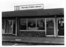
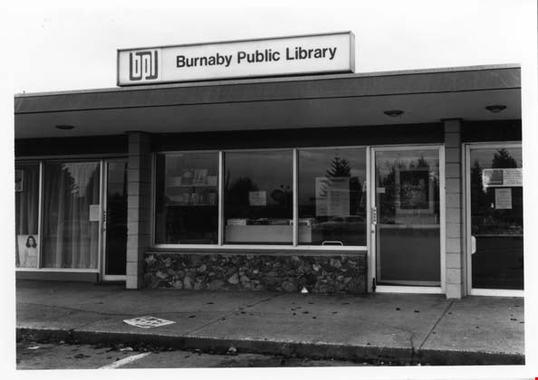
Crest Neighbourhood Library
https://search.heritageburnaby.ca/link/archivedescription93634
- Repository
- City of Burnaby Archives
- Date
- October 23, 1977
- Collection/Fonds
- Burnaby Public Library Contemporary Visual Archive Project
- Description Level
- Item
- Physical Description
- 1 photograph : b&w ; 12.5 x 17.5 cm
- Scope and Content
- Photograph of the exterior of the old Crest Neighbourhood Library branch of the Burnaby Public Library that was located at 8679 10th Avenue in the Crest Shopping Centre. The photograph is taken facing west and focuses on the BPL sign and the library's window displays.
- Repository
- City of Burnaby Archives
- Date
- October 23, 1977
- Collection/Fonds
- Burnaby Public Library Contemporary Visual Archive Project
- Physical Description
- 1 photograph : b&w ; 12.5 x 17.5 cm
- Description Level
- Item
- Record No.
- 556-591
- Access Restriction
- No restrictions
- Reproduction Restriction
- Reproduce for fair dealing purposes only
- Accession Number
- 2017-57
- Scope and Content
- Photograph of the exterior of the old Crest Neighbourhood Library branch of the Burnaby Public Library that was located at 8679 10th Avenue in the Crest Shopping Centre. The photograph is taken facing west and focuses on the BPL sign and the library's window displays.
- Subjects
- Buildings - Civic - Libraries
- Media Type
- Photograph
- Photographer
- Surridge, Jack
- Notes
- Title taken from project information form
- Accompanied by a project information form and 1 photograph (b&w negative ; 9.5 x 12.5 cm)
- BPL no. 40
- Street Address
- 8679 10th Avenue
- Historic Neighbourhood
- East Burnaby (Historic Neighbourhood)
- Planning Study Area
- Cariboo-Armstrong Area
Images
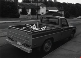
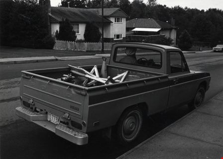
Engineering Department Truck
https://search.heritageburnaby.ca/link/archivedescription79440
- Repository
- City of Burnaby Archives
- Date
- October, 1976
- Collection/Fonds
- Burnaby Public Library Contemporary Visual Archive Project
- Description Level
- Item
- Physical Description
- 1 photograph : b&w ; 11 x 16 cm mounted on cardboard
- Scope and Content
- Photograph shows a District of Burnaby Engineering Department truck with the driver inside, parked on Cumberland Street near 17th Avenue.
- Repository
- City of Burnaby Archives
- Date
- October, 1976
- Collection/Fonds
- Burnaby Public Library Contemporary Visual Archive Project
- Physical Description
- 1 photograph : b&w ; 11 x 16 cm mounted on cardboard
- Description Level
- Item
- Record No.
- 556-292
- Access Restriction
- No restrictions
- Reproduction Restriction
- Reproduce for fair dealing purposes only
- Accession Number
- 2013-13
- Scope and Content
- Photograph shows a District of Burnaby Engineering Department truck with the driver inside, parked on Cumberland Street near 17th Avenue.
- Media Type
- Photograph
- Photographer
- Ross, Martha
- Notes
- Scope note taken directly from BPL photograph description.
- 1 b&w copy negative : 10 x 12.5 cm accompanying
- Geographic Access
- Cumberland Street
- 17th Avenue
- Historic Neighbourhood
- East Burnaby (Historic Neighbourhood)
- Planning Study Area
- Cariboo-Armstrong Area
Images
![Ernest Street family home, [194-?] thumbnail](/media/hpo/_Data/_Archives_Images/_Unrestricted/205/217-002.jpg?width=280)
Ernest Street family home
https://search.heritageburnaby.ca/link/archivedescription36070
- Repository
- City of Burnaby Archives
- Date
- [194-?]
- Collection/Fonds
- Burnaby Historical Society fonds
- Description Level
- Item
- Physical Description
- 1 photograph : col. ; 5.5 x 12 cm print
- Scope and Content
- Photograph of the Ernest Street home after it was altered.
- Repository
- City of Burnaby Archives
- Date
- [194-?]
- Collection/Fonds
- Burnaby Historical Society fonds
- Subseries
- Helen Street subseries
- Physical Description
- 1 photograph : col. ; 5.5 x 12 cm print
- Description Level
- Item
- Record No.
- 217-002
- Access Restriction
- No restrictions
- Reproduction Restriction
- Reproduce for fair dealing purposes only
- Accession Number
- BHS1989-6
- Scope and Content
- Photograph of the Ernest Street home after it was altered.
- Subjects
- Buildings - Residential - Houses
- Media Type
- Photograph
- Notes
- Title based on contents of photograph
- 1 col. copy negative accompanying
- Geographic Access
- Cumberland Street
- Historic Neighbourhood
- East Burnaby (Historic Neighbourhood)
- Planning Study Area
- Cariboo-Armstrong Area
Images
![Ernest Street family home, [194-?] thumbnail](/media/hpo/_Data/_Archives_Images/_Unrestricted/205/217-002.jpg)
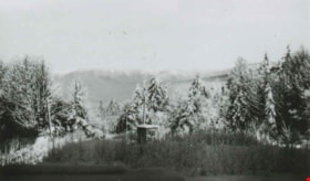
From George Derby Health Centre
https://search.heritageburnaby.ca/link/archivedescription37537
- Repository
- City of Burnaby Archives
- Date
- December 20, 1948 (date of original), copied 1991
- Collection/Fonds
- Burnaby Historical Society fonds
- Description Level
- Item
- Physical Description
- 1 photograph : b&w ; 2.9 x 5.0 cm print on contact sheet 20.2 x 25.3 cm
- Scope and Content
- Photograph taken from the George Derby Health Centre facing north. There is snow on the trees, no buildings are visible except for a small shack, and Burnaby Mountain can be seen in the background.
- Repository
- City of Burnaby Archives
- Date
- December 20, 1948 (date of original), copied 1991
- Collection/Fonds
- Burnaby Historical Society fonds
- Subseries
- Burnaby Image Bank subseries
- Physical Description
- 1 photograph : b&w ; 2.9 x 5.0 cm print on contact sheet 20.2 x 25.3 cm
- Description Level
- Item
- Record No.
- 370-125
- Access Restriction
- No restrictions
- Reproduction Restriction
- No known restrictions
- Accession Number
- BHS1999-03
- Scope and Content
- Photograph taken from the George Derby Health Centre facing north. There is snow on the trees, no buildings are visible except for a small shack, and Burnaby Mountain can be seen in the background.
- Subjects
- Geographic Features - Mountains
- Media Type
- Photograph
- Notes
- Title based on contents of photograph
- 1 b&w copy negative accompanying
- Geographic Access
- Cumberland Street
- Burnaby Mountain Conservation Area
- Street Address
- 7550 Cumberland Street
- Historic Neighbourhood
- East Burnaby (Historic Neighbourhood)
- Planning Study Area
- Cariboo-Armstrong Area
Images

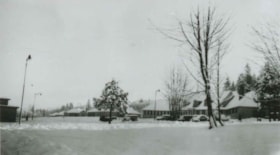
George Derby Health Centre
https://search.heritageburnaby.ca/link/archivedescription37538
- Repository
- City of Burnaby Archives
- Date
- December 20, 1948 (date of original), copied 1991
- Collection/Fonds
- Burnaby Historical Society fonds
- Description Level
- Item
- Physical Description
- 1 photograph : b&w ; 2.9 x 5.2 cm print on contact sheet 20.2 x 25.3 cm
- Scope and Content
- Photograph of the George Derby Health Centre main building and grounds in the snow.
- Repository
- City of Burnaby Archives
- Date
- December 20, 1948 (date of original), copied 1991
- Collection/Fonds
- Burnaby Historical Society fonds
- Subseries
- Burnaby Image Bank subseries
- Physical Description
- 1 photograph : b&w ; 2.9 x 5.2 cm print on contact sheet 20.2 x 25.3 cm
- Description Level
- Item
- Record No.
- 370-126
- Access Restriction
- No restrictions
- Reproduction Restriction
- No known restrictions
- Accession Number
- BHS1999-03
- Scope and Content
- Photograph of the George Derby Health Centre main building and grounds in the snow.
- Subjects
- Buildings - Civic - Hospitals
- Media Type
- Photograph
- Notes
- Title based on contents of photograph
- 1 b&w copy negative accompanying
- Geographic Access
- Cumberland Street
- Street Address
- 7550 Cumberland Street
- Historic Neighbourhood
- East Burnaby (Historic Neighbourhood)
- Planning Study Area
- Cariboo-Armstrong Area
Images
