Narrow Results By
![Lenkurt Electric Company, [1957] thumbnail](/media/Hpo/_Data/_Archives_Images/_Unrestricted/001/099-001.jpg?width=280)
Lenkurt Electric Company
https://search.heritageburnaby.ca/link/archivedescription34690
- Repository
- City of Burnaby Archives
- Date
- [1957]
- Collection/Fonds
- Burnaby Historical Society fonds
- Description Level
- Item
- Physical Description
- 1 photograph : b&w ; 20.3 x 25.3 cm
- Scope and Content
- Photograph of aerial view of the Lenkurt Electric Company at 6960 Lougheed Highway (later renumbered 7018 Lougheed Highway). A sign on the top of the building reads, "Lenkurt." An information sheet from the Company Relation Division of Lenkurt attached to the back of the photograph reads, "Aerial…
- Repository
- City of Burnaby Archives
- Date
- [1957]
- Collection/Fonds
- Burnaby Historical Society fonds
- Subseries
- Photographs subseries
- Physical Description
- 1 photograph : b&w ; 20.3 x 25.3 cm
- Description Level
- Item
- Record No.
- 099-001
- Access Restriction
- No restrictions
- Reproduction Restriction
- Reproduce for fair dealing purposes only
- Accession Number
- BHS2007-04
- Scope and Content
- Photograph of aerial view of the Lenkurt Electric Company at 6960 Lougheed Highway (later renumbered 7018 Lougheed Highway). A sign on the top of the building reads, "Lenkurt." An information sheet from the Company Relation Division of Lenkurt attached to the back of the photograph reads, "Aerial view of a 34,000 square foot building including a 19,000 square foot extension to the existing 15,000 square foot plant of Lenkurt Electric Co. of Canada Ltd. in North Burnaby, B.C., as at May 10th, 1957. / The building is situated on 20 acres of land and faces north onto Lougheed Highway."
- Names
- Lenkurt Electric Company
- Media Type
- Photograph
- Photographer
- Commercial Illustrators Industrial Photographers
- Notes
- Title based on contents of photograph
- Stamp and annotation on back of photograph reads, "TA. 8817 / Commerical Illustrators / Industrial Photographers / 601 Denman St., Vancouver 5, B.C. / File No. 1080-1"
- Geographic Access
- Lougheed Highway
- Street Address
- 7018 Lougheed Highway
- Historic Neighbourhood
- Lozells (Historic Neighbourhood)
- Planning Study Area
- Government Road Area
Images
![Lenkurt Electric Company, [1957] thumbnail](/media/Hpo/_Data/_Archives_Images/_Unrestricted/001/099-001.jpg)
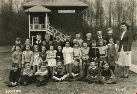
Seaforth School Class
https://search.heritageburnaby.ca/link/archivedescription37340
- Repository
- City of Burnaby Archives
- Date
- 1949
- Collection/Fonds
- Burnaby Historical Society fonds
- Description Level
- Item
- Physical Description
- 1 photograph : b&w ; 12.7 x 17.7 cm
- Scope and Content
- Photograph of twenty-nine students and their teacher seated and standing in rows in front of the school building. A label on the back of the photograph states that the students are from Seaforth School. Identified are the following, back row (l to r): Calvert Broomfield, Billy Beaton, Rod Cardin, …
- Repository
- City of Burnaby Archives
- Date
- 1949
- Collection/Fonds
- Burnaby Historical Society fonds
- Subseries
- Seaforth School subseries
- Physical Description
- 1 photograph : b&w ; 12.7 x 17.7 cm
- Description Level
- Item
- Record No.
- 355-004
- Access Restriction
- No restrictions
- Reproduction Restriction
- Reproduce for fair dealing purposes only
- Accession Number
- BHS1997-14
- Scope and Content
- Photograph of twenty-nine students and their teacher seated and standing in rows in front of the school building. A label on the back of the photograph states that the students are from Seaforth School. Identified are the following, back row (l to r): Calvert Broomfield, Billy Beaton, Rod Cardin, Brian Smith, Connor Werts, Charlie Sunderland, David Werts, John Short, Edward Green, Brude Johnson and Mrs. Mary Johnson (nee Mary MacDonald). Middle row (l to r): Judy Haddon, Sharon Milne, Barbara Smith, Wilma Heather, Betty Hadfield, Merle Beaton, Marcia Noel, Beverly Clarke, Janet Hadfield, Beverly Gamble, Lillian Savage and Joan Dachiuk. Front row (l to r): Billy Smith, Jerry Green, Leigh Tucker, David Park, Eldon Clarke, Joe Haddon and Sammy Savage.
- Names
- Seaforth School
- Johnson, Mary MacDonald
- Broomfield, Calvert
- Beaton, Billy
- Cardin, Rod
- Smith, Brian
- Werts, Connor
- Sunderland, Charlie
- Werts, David
- Short, John
- Green, Edward
- Johnson, Bruce
- Haddon, Judy
- Milne, Sharon
- Smith, Barbara
- Heather, Wilma
- Hadfield, Betty
- Beaton, Merle
- Noel, Marcia
- Clarke, Beverly
- Hadfield, Janet
- Gamble, Beverly
- Savage, Lillian
- Dachiuk, Joan
- Smith, Billy
- Green, Gerry
- Tucker, Leigh
- Park, David
- Clarke, Eldon
- Haddon, Joe
- Savage, Sammy
- Media Type
- Photograph
- Notes
- Title based on label on verso of photograph
- Photographer identified as "Layton"
- Geographic Access
- Government Road
- Deer Lake Avenue
- Street Address
- 7881 Government Road
- 6501 Deer Lake Avenue
- Historic Neighbourhood
- Lozells (Historic Neighbourhood)
- Planning Study Area
- Government Road Area
Images