Narrow Results By
Decade
- 2020s 56
- 2010s 52
- 2000s 24
- 1990s 56
- 1980s 31
- 1970s 53
- 1960s 79
- 1950s 79
- 1940s 59
- 1930s
- 1920s 78
- 1910s 164
- 1900s 76
- 1890s 25
- 1880s 6
- 1870s 3
- 1860s 3
- 1850s 1
- 1840s 1
- 1830s 1
- 1820s 1
- 1810s 1
- 1800s 1
- 1790s 1
- 1780s 1
- 1770s 1
- 1760s 1
- 1750s 1
- 1740s 1
- 1730s 1
- 1720s 1
- 1710s 1
- 1700s 1
- 1690s 1
- 1680s 1
- 1670s 1
- 1660s 1
- 1650s 1
- 1640s 1
- 1630s 1
- 1620s 1
- 1610s 1
- 1600s 1
Creator
- Bancroft, Rose 1
- Bekins Moving and Storage Company Limited 1
- British Columbia Underwriters' Association 4
- Brown, Donald N. "Don" 1
- Burnaby Village Museum 1
- Burnett, David H. 1
- Burnett & McGugan, Engineers and Surveyors 1
- City Map and White Print Co. 1
- City of Burnaby 2
- Coast Map and Blue Print Co. 1
- Digney, Andy 24
- Digney family 1
Person / Organization
- Burnaby Lawn Bowling Club 1
- Codd, Lisa 1
- Digney, Alice 3
- Digney, Andy 18
- Digney Bowling Alley 1
- Digney, Bruce 1
- Digney, Dorothy 1
- Digney, Ernest Frank "Dig" 15
- Digney, Paul 1
- Digney Speedway 2
- Elizabeth, Queen, consort of George VI, King of Great Britain, 1900-2002 1
- George VI, King of Great Britain, 1895-1952 1
Love farmhouse oral history project subseries
https://search.heritageburnaby.ca/link/museumdescription10392
- Repository
- Burnaby Village Museum
- Date
- 1925-1930 (interview content), interviewed between 1988 and 1991
- Collection/Fonds
- Burnaby Village Museum fonds
- Description Level
- Subseries
- Physical Description
- Textual records + 3 audio cassettes + 1 videocassette
- Scope and Content
- Subseries consists of records created and collected during research of the Love family and the Love family farmhouse and include oral history interviews in various formats. Interviews were conducted by Jim Wolf and Burnaby Village Museum curator Colin Stevens with members of the Love family includi…
- Repository
- Burnaby Village Museum
- Collection/Fonds
- Burnaby Village Museum fonds
- Series
- Jesse Love farmhouse series
- Description Level
- Subseries
- Physical Description
- Textual records + 3 audio cassettes + 1 videocassette
- Scope and Content
- Subseries consists of records created and collected during research of the Love family and the Love family farmhouse and include oral history interviews in various formats. Interviews were conducted by Jim Wolf and Burnaby Village Museum curator Colin Stevens with members of the Love family including; Annie Chamberlain, William Parker, Esther Stanley, Albert Parker and Elsie Hughes. Interviews were focused on the subject of the interior and exterior of the farmhouse from a first person perspective. The goal was to obtain as much information as possible from family members in order to accurately restore, furnish and exhibit the farmhouse back to it's original 1920s era.
- Accession Code
- BV018.41
- Access Restriction
- No restrictions
- Reproduction Restriction
- May be restricted by third party rights
- Date
- 1925-1930 (interview content), interviewed between 1988 and 1991
- Media Type
- Textual Record
- Sound Recording
- Moving Images
- Notes
- Title based on content of subseries
Many Voices Project Interviews subseries
https://search.heritageburnaby.ca/link/museumdescription19596
- Repository
- Burnaby Village Museum
- Date
- [1890-2023] (interview content), interviewed 2024
- Collection/Fonds
- Burnaby Village Museum fonds
- Description Level
- Subseries
- Physical Description
- 33 sound recordings (wav) + 3 video recordings (mp4) + 17 sound recordings (mp3) + 1 sound recording (m4a)
- Scope and Content
- Subseries consists of oral history interviews that were conducted as part of Burnaby Village Museum's Many Voices Project to capture and document diverse lives and stories of people connected to Burnaby. Interviews were conducted with Shirley Cohn; Ram Sarap Chandhal and members of Shri Ravidass S…
- Repository
- Burnaby Village Museum
- Collection/Fonds
- Burnaby Village Museum fonds
- Series
- Museum Oral Histories series
- Subseries
- Many Voices Project Interviews subseries
- Description Level
- Subseries
- Physical Description
- 33 sound recordings (wav) + 3 video recordings (mp4) + 17 sound recordings (mp3) + 1 sound recording (m4a)
- Material Details
- Digital master recordings (wav) were recorded onto separate audio tracks. Multiple tracks per interview were edited and merged together and converted to mp3 for access on Heritage Burnaby
- Some of the video recording (mp4) files were edited and saved as audio recording (wav) files
- Scope and Content
- Subseries consists of oral history interviews that were conducted as part of Burnaby Village Museum's Many Voices Project to capture and document diverse lives and stories of people connected to Burnaby. Interviews were conducted with Shirley Cohn; Ram Sarap Chandhal and members of Shri Ravidass Sabha gudawara; Lachman Singh Gill; Joanne Smith; Ellen and Bill Schwartz; Sadhu Binning and Sukhwant Hundal (founders of Vancouver Sath); Samuel Nalliah and Ruth (Angela) Nalliah; Jagandeep "Jag" Nagra; David Skulski; Kanwal Singh Neel; "The Bollywood Boyz" Harv Sihra and Gurvinder Sihra; Jenny Siormanolakis; Bill Gruenthal; Lama Tenzin Sherpa and Lama Sue Salter; Norman Dowad; Richard Liu; Shanaz Khan; Harry Toy; Lisette Pappas; Alex and Georgia Chronakis; Donna Wong and Jeffrey Wong.
- Accession Code
- BV023.16
- BV024.4
- Date
- [1890-2023] (interview content), interviewed 2024
- Media Type
- Sound Recording
- Moving Images
- Notes
- Title based on contents of subseries
- Some of the recordings within this subseries have access restrictions
- Further accruals are expected
Map of Dominion of Canada
https://search.heritageburnaby.ca/link/museumdescription11396
- Repository
- Burnaby Village Museum
- Date
- [1932]
- Collection/Fonds
- Burnaby Village Museum Map collection
- Description Level
- Item
- Physical Description
- 1 map : col. ink on paper ; 50 x 88 cm on paper 58.5 x 96 cm
- Scope and Content
- Item consists of "Map of the Dominion of Canada" produced by the Department of the Interior and the National Development Bureau in 1932. The map includes information about the railway lines in operation and under construction for the Canadian National Railways, Canadian Pacific Railways, and other …
- Repository
- Burnaby Village Museum
- Collection/Fonds
- Burnaby Village Museum Map collection
- Description Level
- Item
- Physical Description
- 1 map : col. ink on paper ; 50 x 88 cm on paper 58.5 x 96 cm
- Material Details
- Scale 100 miles = 1 inch
- Scope and Content
- Item consists of "Map of the Dominion of Canada" produced by the Department of the Interior and the National Development Bureau in 1932. The map includes information about the railway lines in operation and under construction for the Canadian National Railways, Canadian Pacific Railways, and other railways. The map also includes Steamship Routes with distances included.
- Accession Code
- BV006.24.20
- Access Restriction
- No restrictions
- Reproduction Restriction
- May be restricted by third party rights
- Date
- [1932]
- Media Type
- Cartographic Material
- Notes
- Transcribed title
![Map of proposed provincial exhibition site at Burnaby Lake, [between 1929 and 1931] thumbnail](/media/hpo/_Data/_BVM_Cartographic_Material/2017/2017_0002_0009_005.jpg?width=280)
Map of proposed provincial exhibition site at Burnaby Lake
https://search.heritageburnaby.ca/link/museumdescription8703
- Repository
- Burnaby Village Museum
- Date
- [between 1929 and 1931]
- Collection/Fonds
- Burnaby Village Museum Map collection
- Description Level
- Item
- Physical Description
- 1 map : photostat print ; 3 parts 45 x 33.7 cm totalling 45 x 101 cm
- Scope and Content
- Item consists of a tri-part folding map of a proposed Provincial Exhibition site located along the southern and western shore of Burnaby Lake. Exhibtion site on map identifies proposed locations for a golf course, pier, hydroplane landing ramp, sports ground, one-mile horse racing track and various…
- Repository
- Burnaby Village Museum
- Collection/Fonds
- Burnaby Village Museum Map collection
- Description Level
- Item
- Physical Description
- 1 map : photostat print ; 3 parts 45 x 33.7 cm totalling 45 x 101 cm
- Material Details
- Scale [1:1800]
- Scope and Content
- Item consists of a tri-part folding map of a proposed Provincial Exhibition site located along the southern and western shore of Burnaby Lake. Exhibtion site on map identifies proposed locations for a golf course, pier, hydroplane landing ramp, sports ground, one-mile horse racing track and various buildings for mechanical, agricultural and botanical displays.
- Subjects
- Exhibitions
- Accession Code
- BV017.2.9
- Access Restriction
- No restrictions
- Reproduction Restriction
- No known restrictions
- Date
- [between 1929 and 1931]
- Media Type
- Cartographic Material
- Historic Neighbourhood
- Burnaby Lake (Historic Neighbourhood)
- Planning Study Area
- Burnaby Lake Area
- Scan Resolution
- 400
- Scan Date
- 2021-11-18
- Notes
- Title based on contents of map
- Scale on map reads: "150 feet to 1 inch"
- Overall measurements when fully opened: L: 98.0 cm x H: 45.3 cm ; Individual map parts: L: 32.7 cm x H: 45.0 cm
- Commercially printed label on front of portfolio card reads "PLOWRIGHT PRINTING COMPANY / TELEPHONE N.W. 1942 / 39 McKENZIE STREET NEW WESTMINSTER, B.C. / TO: [illegible writing in pencil]" in blue ink. Red typewritten text reads: "PHOTOSTAT OF BURNABY LAKE".
Images
![Map of proposed provincial exhibition site at Burnaby Lake, [between 1929 and 1931] thumbnail](/media/hpo/_Data/_BVM_Cartographic_Material/2017/2017_0002_0009_005.jpg)


Map of Vancouver
https://search.heritageburnaby.ca/link/archivedescription65805
- Repository
- City of Burnaby Archives
- Date
- 1935
- Collection/Fonds
- Burnaby Historical Society fonds
- Description Level
- Item
- Physical Description
- 1 map : col. on paper ; 51 x 71 cm folded to 19 x 10 cm
- Scope and Content
- Item is a "Map of Vancouver, New Westminster, Burnaby and North Shore" published by City Map & White Print Co. of Vancouver.
- Repository
- City of Burnaby Archives
- Date
- 1935
- Collection/Fonds
- Burnaby Historical Society fonds
- Subseries
- Bernard Bellinger subseries
- Physical Description
- 1 map : col. on paper ; 51 x 71 cm folded to 19 x 10 cm
- Description Level
- Item
- Record No.
- 42675
- Accession Number
- BHS1991-08
- Scope and Content
- Item is a "Map of Vancouver, New Westminster, Burnaby and North Shore" published by City Map & White Print Co. of Vancouver.
- Media Type
- Cartographic Material
Mary Forsyth fonds
https://search.heritageburnaby.ca/link/archivedescription87823
- Repository
- City of Burnaby Archives
- Date
- [1893] (date of original) -2004
- Collection/Fonds
- Mary Forsyth fonds
- Description Level
- Fonds
- Physical Description
- Textual records, graphic material and cartographic material
- Scope and Content
- Records consist of material created and collected by Mary Forsyth. Records include correspondence, photographs, a map, presentation notes, and reviews along with research for historical and biographical essays pertaining to pioneering families, organizations, and the geographical area of South Burn…
- Repository
- City of Burnaby Archives
- Date
- [1893] (date of original) -2004
- Collection/Fonds
- Mary Forsyth fonds
- Physical Description
- Textual records, graphic material and cartographic material
- Description Level
- Fonds
- Reproduction Restriction
- May be restricted by third party rights
- Accession Number
- 2014-27
- Scope and Content
- Records consist of material created and collected by Mary Forsyth. Records include correspondence, photographs, a map, presentation notes, and reviews along with research for historical and biographical essays pertaining to pioneering families, organizations, and the geographical area of South Burnaby. One of her major research projects consists of "A Walking Environment for South Burnaby," which also became a proposal to The Corporation of the District of Burnaby. Historical information and photographs pertaining to South Burnaby pioneer families and organizations were compiled from interviews with the intention of publishing a book.
- History
- Mary Gertrude (Bolton) Forsyth was born at her parents' home in Burnaby on March 5, 1923, and was the daughter of Richard Bolton and Gertrude (nee Hern). Mary's father, Richard, immigrated to Canada from Sunderland, England, in 1911. He lived with his brother George in New Westminster prior to purchasing property in South Burnaby in 1916 and built a bungalow located at 859 Marine Drive. Richard Bolton was employed as the municipal treasurer for the Corporation of the District of Burnaby and, in 1919, he returned to Sunderland with three months leave of absence to marry Mary Gertrude Hern, daughter of Captain and Mrs. John Hern. Mary grew up with her parents and sister Nancy in the house that her father built on Marine Drive. She married Lloyd Forsyth in 1946 and they had two children, Diane and Robert. Mary and her husband raised their family in Burnaby and built a house at 855 Marine Drive, on the lot originally purchased by her father, and moved later to a house located at 6457 Marine Drive. In 1964, after her children were grown, Mary completed her teaching degree at Simon Fraser University and went on to teach kindergarten at Nelson Elementary School. While a teacher within the Burnaby School District, Mary was instrumental in adopting ballet as part of the school curriculum. Mary was an active member of the Burnaby Historical Society, participating and leading local events and seminars. She was inspired by the idea of the 'Housewives Holiday', originally initiated by the Vancouver "Y’ S". In February 1960, she was integral in forming a committee in South Burnaby, working alongside Ruth Turner, Faye Treagh, and Dorothy Turnbull. The "Housewives Holiday" committee (a branch of the Clinton-Glenwood Recreation Association) planned several events at Bonsor Hall for Burnaby housewives from October 6 to December 8, 1960. After her retirement from teaching, Mary returned to Simon Fraser University to do further studies and, in 1983, she wrote an essay for an Environmental Education course, titled "A Walking Environment for South Burnaby". The essay was conducted as a feasibility study to provide a walking environment in her community and included a formal essay, a media book, a map, and a slide presentation which was presented to a variety of local community groups. In 1984, Mary was the recipient of the North Fraser Harbour Commission Award to further her work on this project. In October 1986, her essay was adapted as a proposal to The Corporation of the District of Burnaby for a walking and cycling trail system for South Burnaby. Her proposal was taken into consideration by council and was later adopted by the Parks and Recreation Commission. Mary was very much interested in the history of South Burnaby and spent time between 1990 to 2004 conducting research through the Burnaby Historical Society, The City of Burnaby Archives, and several pioneering families who agreed to share their family records and be interviewed. Mary compiled her research into short historical and biographical essays by geographical area, family name, and organization. Mary (Bolton) Forsyth lived her whole life in South Burnaby and was an active and committed member of her community. She died on November 10, 2010.
- Media Type
- Textual Record
- Photograph
- Cartographic Material
- Creator
- Forsyth, Mary
- Notes
- Title based on contents of fonds
- Photo catalogue 572, MSS185
Maurice Phillips collection
https://search.heritageburnaby.ca/link/archivedescription66716
- Repository
- City of Burnaby Archives
- Date
- 1930-1950
- Collection/Fonds
- Maurice Phillips collection
- Description Level
- Fonds
- Physical Description
- 3 maps + 1 brochure
- Scope and Content
- Collection consists of three maps; 1936 Burnaby lot map, 1950 map of the Fraser Valley, 1950s map of the Fraser Canyon and one brochure entitled "Corporation of Burnaby Attractively Priced Lands."
- Repository
- City of Burnaby Archives
- Date
- 1930-1950
- Collection/Fonds
- Maurice Phillips collection
- Physical Description
- 3 maps + 1 brochure
- Description Level
- Fonds
- Accession Number
- 2011-13
- Scope and Content
- Collection consists of three maps; 1936 Burnaby lot map, 1950 map of the Fraser Valley, 1950s map of the Fraser Canyon and one brochure entitled "Corporation of Burnaby Attractively Priced Lands."
- History
- Maurice Phillips was born in Victoria in 1919 and moved to East Pender Street in Vancouver during the 1930s. As a young man, he served as a cadet in the Seaforth Armory. When World War II broke out, Maurice was sent overseas with the First Battalion Seaforth Highlanders. This is where he met his future wife, Betty Joyce Thomas, who was herself serving as a member of the British Woman's Land Army (WLA). Maurice and Betty were married in Brighton, Sussex, in 1943. Betty (Thomas) Phillips travelled to Canada via the Queen Mary and stayed with Maurice's sisters and mother in Vancouver so that her daughter, Judith Phillips, would be born in Canada in 1944. Maurice was in Europe until 1945 and ended up as a Captain in the army. After the war, Maurice returned to work at Woodwards but, through his army contacts, went to work at Barber-Ellis, a wholesale paper and envelope manufacturer. He and his wife and daughter moved to Burnaby in 1948 or 1949, first on Royal Oak and then to a house on Waltham. This is where their son, William George Phillips, was born in 1950 and their second daughter, Susan Maureen Phillips, was born in 1953. The Phillips family often took trips to the Okanagan after the Hope-Princeton highway opened. Maurice also took William to Sḵwx̱wú7mesh along the "new" highway when it first opened. The Phillips family lived in Burnaby until Maurice was transferred east in 1960.
- Media Type
- Textual Record
- Cartographic Material
- Creator
- Phillips, Maurice
- Notes
- Title based on contents of fonds
- MSS158
Municipality of Burnaby
https://search.heritageburnaby.ca/link/archivedescription89271
- Repository
- City of Burnaby Archives
- Date
- [1936-1937]
- Collection/Fonds
- Burnaby Historical Society fonds
- Description Level
- Item
- Physical Description
- 1 map : canvas, handcoloured ; 140 x 80 cm
- Scope and Content
- Item is a canvas map of Municipality of Burnaby created by City Map and White Print Co.
- Repository
- City of Burnaby Archives
- Date
- [1936-1937]
- Collection/Fonds
- Burnaby Historical Society fonds
- Subseries
- North Burnaby Board of Trade subseries
- Physical Description
- 1 map : canvas, handcoloured ; 140 x 80 cm
- Description Level
- Item
- Record No.
- MSS118-009
- Access Restriction
- No restrictions
- Accession Number
- BHS2005-8
- Scope and Content
- Item is a canvas map of Municipality of Burnaby created by City Map and White Print Co.
- Media Type
- Cartographic Material
![Municipality of Burnaby, [between 1910 and 1930] thumbnail](/media/hpo/_Data/_BVM_Cartographic_Material/2008/2008_0024_0001_002.jpg?width=280)
Municipality of Burnaby
https://search.heritageburnaby.ca/link/museumdescription8702
- Repository
- Burnaby Village Museum
- Date
- [between 1910 and 1930]
- Collection/Fonds
- Burnaby Village Museum Map collection
- Description Level
- Item
- Physical Description
- 1 map : blackline print with col. ; 83 x 53 cm on sheet 92 x 61 cm
- Scope and Content
- Item consists of "Municipality of Burnaby" map outlining waterlines, telephone lines, lights and power lines, and street lights. A section of the upper left corner (borded by Boundary Road to the west; Queens Ave to the east; Burrard Inlet to the north and Parker Avenue to the south) of map is han…
- Repository
- Burnaby Village Museum
- Collection/Fonds
- Burnaby Village Museum Map collection
- Description Level
- Item
- Physical Description
- 1 map : blackline print with col. ; 83 x 53 cm on sheet 92 x 61 cm
- Material Details
- Scale 10 chains = 1 inch
- Scope and Content
- Item consists of "Municipality of Burnaby" map outlining waterlines, telephone lines, lights and power lines, and street lights. A section of the upper left corner (borded by Boundary Road to the west; Queens Ave to the east; Burrard Inlet to the north and Parker Avenue to the south) of map is hand coloured in red with "Queens Avenue" and "Parker Avenue" identified.
- Creator
- Coast Map and Blue Print Co.
- Responsibility
- Municipal Council of Burnaby
- Accession Code
- BV008.24.1
- Access Restriction
- No restrictions
- Reproduction Restriction
- No known restrictions
- Date
- [between 1910 and 1930]
- Media Type
- Cartographic Material
- Scan Resolution
- 300
- Scan Date
- 2022-05-10
- Notes
- Transcribed title
- "COMPILED EXPRESSLY FOR / THE MUNICIPAL COUNCIL OF BURNABY/ BY/ THE COAST MAP AND BLUE PRINT CO/ EMPIRE BLDG VANCOUVER B.C."
Images
![Municipality of Burnaby, [between 1910 and 1930] thumbnail](/media/hpo/_Data/_BVM_Cartographic_Material/2008/2008_0024_0001_002.jpg)

Municipality of Burnaby
https://search.heritageburnaby.ca/link/museumdescription13096
- Repository
- Burnaby Village Museum
- Date
- 1936
- Collection/Fonds
- Burnaby Village Museum Map collection
- Description Level
- Item
- Physical Description
- 1 map : b&w print on paper ; 59 x 43 cm
- Scope and Content
- Map of the Municipality of Burnaby compiled and published by City Map and White Print Co.
- Repository
- Burnaby Village Museum
- Collection/Fonds
- Burnaby Village Museum Map collection
- Description Level
- Item
- Physical Description
- 1 map : b&w print on paper ; 59 x 43 cm
- Scope and Content
- Map of the Municipality of Burnaby compiled and published by City Map and White Print Co.
- Creator
- City Map and White Print Co.
- Publisher
- City Map and White Print Co.
- Accession Code
- HV976.158.7
- Access Restriction
- No restrictions
- Reproduction Restriction
- No known restrictions
- Date
- 1936
- Media Type
- Cartographic Material
- Scan Resolution
- 600
- Scan Date
- 2022-04-06
- Scale
- 100
- Notes
- Title based on content of map
- Title on map reads: "MUNICIPALITY / OF / BURNABY / BRITISH COLUMBIA / Compiled and Published by / CITY MAP AND WHITE PRINT CO."
- Stamp on map reads: "SFU LIBRARY / SEP 1974 / G. 3514 / B87 / 1936"
- Stamp on map reads: "SFU LIBRARY / AUG 1973 / G. 3514 / B87 / 1936"
- Cirular seal stamp on map reads: "The University of / Library / British Columbia"
Zoomable Images

Municipality of Burnaby
https://search.heritageburnaby.ca/link/archivedescription65821
- Repository
- City of Burnaby Archives
- Date
- November 1936
- Collection/Fonds
- Burnaby Historical Society fonds
- Description Level
- Item
- Physical Description
- 1 map : b&w on paper ; 80 x 55 cm folded to 18 x 10 cm, in cover 19 x 23 cm folded to 19 x 12 cm
- Scope and Content
- Item is a map of the "Municipality of Burnaby" compiled and published by City Map and White Print Co.
- Repository
- City of Burnaby Archives
- Date
- November 1936
- Collection/Fonds
- Burnaby Historical Society fonds
- Subseries
- Ephemera subseries
- Physical Description
- 1 map : b&w on paper ; 80 x 55 cm folded to 18 x 10 cm, in cover 19 x 23 cm folded to 19 x 12 cm
- Material Details
- Information on cover is in green ink
- Scale : 1 inch = 1600 feet
- Description Level
- Item
- Record No.
- 42682
- Accession Number
- BHS1991-35
- Scope and Content
- Item is a map of the "Municipality of Burnaby" compiled and published by City Map and White Print Co.
- Media Type
- Cartographic Material
- Edition
- Copyright 1934, revised November 1936
Municipality of Burnaby
https://search.heritageburnaby.ca/link/archivedescription66732
- Repository
- City of Burnaby Archives
- Date
- November 1936
- Collection/Fonds
- Maurice Phillips collection
- Description Level
- Item
- Physical Description
- 1 map : b&w on paper ; 80 x 55 cm folded to 18 x 10 cm, in cover 19 x 23 cm folded to 19 x 12 cm
- Scope and Content
- Item is a map of the "Municipality of Burnaby" compiled and published by City Map and White Print Co.
- Repository
- City of Burnaby Archives
- Date
- November 1936
- Collection/Fonds
- Maurice Phillips collection
- Physical Description
- 1 map : b&w on paper ; 80 x 55 cm folded to 18 x 10 cm, in cover 19 x 23 cm folded to 19 x 12 cm
- Material Details
- Information on cover is in green ink
- Scale : 1 inch = 1600 feet
- Description Level
- Item
- Record No.
- MSS158-004
- Accession Number
- 2011-13
- Scope and Content
- Item is a map of the "Municipality of Burnaby" compiled and published by City Map and White Print Co.
- Media Type
- Cartographic Material
- Edition
- Copyright 1934, revised November 1936
- Notes
- Transcribed title
![Municipality of Burnaby - Volume XV and Volume XVIII, 1927-[1940] thumbnail](/media/hpo/_Data/_BVM_Artifacts/1972/1972_0111_0004_003.jpg?width=280)
Municipality of Burnaby - Volume XV and Volume XVIII
https://search.heritageburnaby.ca/link/museumdescription8682
- Repository
- Burnaby Village Museum
- Date
- 1927-[1940]
- Collection/Fonds
- Burnaby Village Museum Map collection
- Description Level
- File
- Physical Description
- 4 plans on 4 sheets: col. lithographic prints ; 63.5 x 53.5 cm folded to 53 x 31.5 cm
- Scope and Content
- File consists of four pages of plans removed from a bound book containing a series of fire insurance plans of the Municipality of Burnaby. Plan "1518" and "1519" are from "GREATER VANCOUVER B.C. / VOLUME XV / Municipality of Burnaby / May, 1927". Plan "1518" covers District Lot 116 and Plan "1519"…
- Repository
- Burnaby Village Museum
- Collection/Fonds
- Burnaby Village Museum Map collection
- Description Level
- File
- Physical Description
- 4 plans on 4 sheets: col. lithographic prints ; 63.5 x 53.5 cm folded to 53 x 31.5 cm
- Material Details
- Scale [1:600]
- Scope and Content
- File consists of four pages of plans removed from a bound book containing a series of fire insurance plans of the Municipality of Burnaby. Plan "1518" and "1519" are from "GREATER VANCOUVER B.C. / VOLUME XV / Municipality of Burnaby / May, 1927". Plan "1518" covers District Lot 116 and Plan "1519" covers District Lot 121. Plan "1802" and plan "1803" are from "GREATER VANCOUVER B.C. / VOLUME XVIII / Municipality of Burnaby / May, 1927". Both plans "1802" and "1803" cover District Lot 153.
- Responsibility
- British Columbia Underwriters' Association
- Accession Code
- HV972.111.4
- Access Restriction
- No restrictions
- Reproduction Restriction
- May be restricted by third party rights
- Date
- 1927-[1940]
- Media Type
- Cartographic Material
- Historic Neighbourhood
- Vancouver Heights (Historic Neighbourhood)
- Central Park (Historic Neighbourhood)
- Planning Study Area
- Willingdon Heights Area
- Marlborough Area
- Scan Resolution
- 400
- Scan Date
- 2021-11-18
- Notes
- Title based on content of plans
- See also BV987.1.70d for revised versions of plans
- Scale is measured 1 inch = 50 feet
- Contact Burnaby Village Museum to access plans 1518 and 1519 (these plans have revisions on top - date of revisions is uncertain)
Images
![Municipality of Burnaby - Volume XV and Volume XVIII, 1927-[1940] thumbnail](/media/hpo/_Data/_BVM_Artifacts/1972/1972_0111_0004_003.jpg)

Museum Oral Histories series
https://search.heritageburnaby.ca/link/museumdescription18810
- Repository
- Burnaby Village Museum
- Date
- [1600-2023] (interview content), interviewed 2005-2023
- Collection/Fonds
- Burnaby Village Museum fonds
- Description Level
- Series
- Physical Description
- 52 sound recordings (wav) + 61 sound recordings (mp3) + 1 video recording (mp4) + 1 sound recording (m4a) + 51 video recordings (mov)
- Scope and Content
- Series consists of oral history interviews conducted by staff of Burnaby Village Museum for various projects. Series has been arranged into subseries: 1) Growing Up in Burnaby subseries 2) Museum research interviews subseries 3) Chinese Canadians in Burnaby subseries 4) South Asian Canadian Interv…
- Repository
- Burnaby Village Museum
- Collection/Fonds
- Burnaby Village Museum fonds
- Series
- Museum Oral Histories series
- Description Level
- Series
- Physical Description
- 52 sound recordings (wav) + 61 sound recordings (mp3) + 1 video recording (mp4) + 1 sound recording (m4a) + 51 video recordings (mov)
- Scope and Content
- Series consists of oral history interviews conducted by staff of Burnaby Village Museum for various projects. Series has been arranged into subseries: 1) Growing Up in Burnaby subseries 2) Museum research interviews subseries 3) Chinese Canadians in Burnaby subseries 4) South Asian Canadian Interviews subseries 5) Many Voices Project Interviews subseries
- Accession Code
- BV017.45
- BV018.18.1
- BV019.13.1
- BV019.14.1
- BV019.15.1
- BV020.6
- BV022.29
- BV023.1
- BV023.16
- BV024.4
- Date
- [1600-2023] (interview content), interviewed 2005-2023
- Media Type
- Sound Recording
- Moving Images
- Notes
- Title based on contents of series
- Further accruals expected
North Fraser Harbour Board - Financial statements, reports, bylaws
https://search.heritageburnaby.ca/link/archivedescription1390
- Repository
- City of Burnaby Archives
- Date
- 1926-1958
- Collection/Fonds
- City Council and Office of the City Clerk fonds
- Description Level
- File
- Physical Description
- 2 folders textual records and cartographic material
- Scope and Content
- File includes blueprint plan regarding foreshore application fronting.
- Repository
- City of Burnaby Archives
- Date
- 1926-1958
- Collection/Fonds
- City Council and Office of the City Clerk fonds
- Physical Description
- 2 folders textual records and cartographic material
- Description Level
- File
- Record No.
- 3198
- Accession Number
- 2001-02
- Scope and Content
- File includes blueprint plan regarding foreshore application fronting.
- Media Type
- Textual Record
- Cartographic Material
- Notes
- Plans/maps are located in file and have not been moved to map case.
![Oak Theatre, [between 1937 and 1936] thumbnail](/media/Hpo/_Data/_Archives_Moving_Images/_Unrestricted/562-002-1.jpg?width=280)
Oak Theatre
https://search.heritageburnaby.ca/link/archivedescription85202
- Repository
- City of Burnaby Archives
- Date
- [between 1937 and 1936]
- Collection/Fonds
- Digney Family fonds
- Description Level
- Item
- Physical Description
- 1 film clip (9 min., 26 sec.) : digital, col., si.
- Scope and Content
- Item is a digitized copy of a silent colour film segment with footage of the construction of the Oak Theatre in 1936, the opening of the theatre held on August 4, 1937, the theatre with snow in the winter and the Digney family home and neighborhood . Andy Digney moved with his family from Manitoba …
- Repository
- City of Burnaby Archives
- Date
- [between 1937 and 1936]
- Collection/Fonds
- Digney Family fonds
- Physical Description
- 1 film clip (9 min., 26 sec.) : digital, col., si.
- Description Level
- Item
- Record No.
- 562-002-1
- Access Restriction
- No restrictions
- Reproduction Restriction
- May be restricted by third party rights
- Accession Number
- 2012-15
- Scope and Content
- Item is a digitized copy of a silent colour film segment with footage of the construction of the Oak Theatre in 1936, the opening of the theatre held on August 4, 1937, the theatre with snow in the winter and the Digney family home and neighborhood . Andy Digney moved with his family from Manitoba to Burnaby in 1936 and purchased 2 acres of land where he settled with his family and built the Oak Theatre which was located at 5000 Kingsway (Marlborough & Kingsway). The theatre was located on a 2 acre parcel of land and had a 350 seat capacity and offered valet parking. Construction crews with men and horses can be seen laying the foundation and erecting the walls of the theatre and crowds of people and cars are seen arriving outside the theatre on opening day.
- Subjects
- Events - Openings
- Buildings - Commercial - Theatres
- Recreational Activities - Theatre
- Animals - Horses
- Names
- Oak Theatre
- Digney, Andy
- Media Type
- Moving Images
- Photographer
- Digney, Andy
- Creator
- Digney, Andy
- Notes
- Title based on contents of film
- Film clip originates from digitized version of original 16 mm film footage (item 562-002). This segment was part of digitized portion titled 'Oak Theatre'
- Historic Neighbourhood
- Central Park (Historic Neighbourhood)
- Planning Study Area
- Sussex-Nelson Area
Images
![Oak Theatre, [between 1937 and 1936] thumbnail](/media/Hpo/_Data/_Archives_Moving_Images/_Unrestricted/562-002-1.jpg)
Video
Oak Theatre, [between 1937 and 1936]
Oak Theatre, [between 1937 and 1936]
https://search.heritageburnaby.ca/media/hpo/_Data/_Archives_Moving_Images/_Unrestricted/562-002-1.m4vOrders of Board of Railway Commission - Gilmore Avenue crossing
https://search.heritageburnaby.ca/link/archivedescription1485
- Repository
- City of Burnaby Archives
- Date
- 1928-1958
- Collection/Fonds
- City Council and Office of the City Clerk fonds
- Description Level
- File
- Physical Description
- 2 folders textual records and cartographic material
- Scope and Content
- Files contains white linen plan that accompanies railway application for highway crossing at Gilmore Avenue (1929) and 2 blueprint plans - one of the railway highway crossing protection at Bell and Sperling Avenue (1952) and the other at Bell and Douglas Avenue (1947).
- Repository
- City of Burnaby Archives
- Date
- 1928-1958
- Collection/Fonds
- City Council and Office of the City Clerk fonds
- Physical Description
- 2 folders textual records and cartographic material
- Description Level
- File
- Record No.
- 3296
- Accession Number
- 2001-02
- Scope and Content
- Files contains white linen plan that accompanies railway application for highway crossing at Gilmore Avenue (1929) and 2 blueprint plans - one of the railway highway crossing protection at Bell and Sperling Avenue (1952) and the other at Bell and Douglas Avenue (1947).
- Media Type
- Textual Record
- Cartographic Material
- Notes
- Plans/maps are located in file and have not been moved to map case.
![Parades, [between 1936 and 1948] thumbnail](/media/Hpo/_Data/_Archives_Moving_Images/_Unrestricted/562-003-11.jpg?width=280)
Parades
https://search.heritageburnaby.ca/link/archivedescription85248
- Repository
- City of Burnaby Archives
- Date
- [between 1936 and 1948]
- Collection/Fonds
- Digney Family fonds
- Description Level
- Item
- Physical Description
- 1 film clip (11 min., 17sec.) :digital, b&w, col., si.
- Scope and Content
- Item is a digitized silent colour film segment identified as Reel 11. Film opens with colour footage of the Tacoma Daffodil Parade and switches to some black and white and colour footage of the Vancouver Diamond Jubilee Parade starting from the Toronto Dominion Bank located at Hastings Street and C…
- Repository
- City of Burnaby Archives
- Date
- [between 1936 and 1948]
- Collection/Fonds
- Digney Family fonds
- Physical Description
- 1 film clip (11 min., 17sec.) :digital, b&w, col., si.
- Description Level
- Item
- Record No.
- 562-003-11
- Access Restriction
- No restrictions
- Reproduction Restriction
- May be restricted by third party rights
- Accession Number
- 2014-04
- Scope and Content
- Item is a digitized silent colour film segment identified as Reel 11. Film opens with colour footage of the Tacoma Daffodil Parade and switches to some black and white and colour footage of the Vancouver Diamond Jubilee Parade starting from the Toronto Dominion Bank located at Hastings Street and Cambie Street. The Queen appears in a calvicade at the beginning of the parade. The footage soon switches to the Vancouver PNC Parade in 1946 celebrating 50 years of progress.
- Subjects
- Events - Parades
- Media Type
- Moving Images
- Photographer
- Digney, Andy
- Creator
- Digney, Andy
- Notes
- Title based on contents of film
Images
![Parades, [between 1936 and 1948] thumbnail](/media/Hpo/_Data/_Archives_Moving_Images/_Unrestricted/562-003-11.jpg)
Video
Parades, [between 1936 and 1948]
Parades, [between 1936 and 1948]
https://search.heritageburnaby.ca/media/hpo/_Data/_Archives_Moving_Images/_Unrestricted/562-003-11.m4v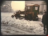
Ploughing snow at the Oak Theatre
https://search.heritageburnaby.ca/link/archivedescription85471
- Repository
- City of Burnaby Archives
- Date
- 1939
- Collection/Fonds
- Digney Family fonds
- Description Level
- Item
- Physical Description
- 1 film clip (45 sec.) : digital, col. ; si.
- Scope and Content
- Item is a digitized copy of a silent colour film segment of a snow plough ploughing snow in the parking lot outside the Oak Theatre.
- Repository
- City of Burnaby Archives
- Date
- 1939
- Collection/Fonds
- Digney Family fonds
- Physical Description
- 1 film clip (45 sec.) : digital, col. ; si.
- Description Level
- Item
- Record No.
- 562-002-7
- Access Restriction
- No restrictions
- Reproduction Restriction
- No known restrictions
- Accession Number
- 2012-15
- Scope and Content
- Item is a digitized copy of a silent colour film segment of a snow plough ploughing snow in the parking lot outside the Oak Theatre.
- Subjects
- Natural Phenomena - Snow
- Media Type
- Moving Images
- Photographer
- Digney, Andy
- Creator
- Digney, Andy
- Notes
- Title based on contents of film
- Film clip originates from digitized version of original 16 mm film footage (item 562-002). This segment was part of digitized portion titled 'Royal Visit'
- Geographic Access
- Central Park
- Kingsway
- Historic Neighbourhood
- Central Park (Historic Neighbourhood)
- Planning Study Area
- Sussex-Nelson Area
Images
Video
Ploughing snow at the Oak Theatre, 1939
Ploughing snow at the Oak Theatre, 1939
https://search.heritageburnaby.ca/media/hpo/_Data/_Archives_Moving_Images/_Unrestricted/562-002-7.m4v
Proposed sidewalk on grounds of Kingsway West School
https://search.heritageburnaby.ca/link/museumdescription11917
- Repository
- Burnaby Village Museum
- Date
- March 24, 1932
- Collection/Fonds
- Ronald G. Scobbie collection
- Description Level
- Item
- Physical Description
- 1 survey plan : ink on waxed linen sheet ; 55 x 25 cm
- Scope and Content
- Item consists of a survey plan titled “Plan Showing Proposed / Sidewalk on Grounds of / Kingsway West School”
- Repository
- Burnaby Village Museum
- Collection/Fonds
- Ronald G. Scobbie collection
- Description Level
- Item
- Physical Description
- 1 survey plan : ink on waxed linen sheet ; 55 x 25 cm
- Material Details
- Scale 20’=1”
- Scope and Content
- Item consists of a survey plan titled “Plan Showing Proposed / Sidewalk on Grounds of / Kingsway West School”
- Creator
- McGugan, Donald Johnston
- Names
- Kingsway West School
- Accession Code
- BV003.83.40
- Access Restriction
- No restrictions
- Reproduction Restriction
- No known restrictions
- Date
- March 24, 1932
- Media Type
- Cartographic Material
- Scan Resolution
- 600
- Scan Date
- 15-Jan-2021
- Scale
- 100
- Notes
- Transcribed title
- Note in pencil reads: ‘4222”
Images
