Ronald G. Scobbie collection
https://search.heritageburnaby.ca/link/museumdescription11914
- Repository
- Burnaby Village Museum
- Date
- [1890]-1932
- Collection/Fonds
- Ronald G. Scobbie collection
- Description Level
- Fonds
- Physical Description
- 55 plans + 2 architectural drawings + 1 map + graphic materials + 3 cm of textual records
- Scope and Content
- Fonds consists of survey and subdivision plans, a map and records created by Provincial Land Surveyors Albert J. Hill and Geoffrey K. Burnett and Donald Johnson McGugan and collected by Ronald G. Scobbie. Records include subdivision and survey plans in New Westminster District Group 1 including Dis…
- Repository
- Burnaby Village Museum
- Collection/Fonds
- Ronald G. Scobbie collection
- Description Level
- Fonds
- Physical Description
- 55 plans + 2 architectural drawings + 1 map + graphic materials + 3 cm of textual records
- Scope and Content
- Fonds consists of survey and subdivision plans, a map and records created by Provincial Land Surveyors Albert J. Hill and Geoffrey K. Burnett and Donald Johnson McGugan and collected by Ronald G. Scobbie. Records include subdivision and survey plans in New Westminster District Group 1 including District Lots in Burnaby along with various school sites and church plans; surveying records regarding North Road and a map of the Burnaby Municipality. Fonds is arranged into series: 1) Subdivision and survey plans series 2) School and church plans series 3) Map series
- History
- Ronald G. Scobbie was born in Scotland. After graduating from high school, he worked in the mines of Scotland which led to a career as a land surveyor. Ron immigrated to Canada in 1965 and settled in North Vancouver. In 1967 he became a partner in the surveying company of Hunter, Crockford & Scobbie in New Westminster, eventually owning it under the title Scobbie and Associates between 1980 and 1995. Ron sold the business in 1995 and retired as a BC Land Surveyor in December 2003. Ron was an active member of the B.C. Land Surveyors Association and an avid collector of surveying equipment and maps and plans that document the history of surveying in British Columbia. Upon retirement, Ron donated many historical maps and plans to various repositories located in different geographical regions throughout B.C.
- Scobbie & Associates land surveying company dates back to 1890 when Albert J. Hill first established his practice as a land surveyor in New Westminster. The company went through a series of Surveyors (owners) between 1890 and 1995:
- Albert James Hill (A.J. Hill) [1890] to 1912
- Hill & Burnett 1911 to 1912
- Geoffrey K. Burnett 1912
- Burnett & McGugan 1912 to 1947
- Burnett, McGugan & Hunter 1947 to 1959
- Burnett, Hunter & Douglas 1959 to 1960
- Hunter, Douglas & Crockford 1960 to 1964
- Hunter, Crockford & Associates 1964 to 1965
- Hunter, Crockford & Aplin 1965 to 1967
- Hunter, Crockford & Scobbie 1967 to 1973
- Crockford, Scobbie & Associates 1973-1980
- Scobbie & Associates 1980 to 1995
- Responsibility
- Scobbie, Ronald G.
- Accession Code
- HV984.57
- BV003.83
- Access Restriction
- No restrictions
- Reproduction Restriction
- No known restrictions
- Date
- [1890]-1932
- Related Material
- For other survey and subdivision plans created by land surveyors Albert J. Hill, Geoffery K. Burnett and Donald J. McGugan, see: Burnaby Village Museum Map collection - Survey and Subdivision plans series
- Notes
- Title based on contents of collection
School and church plans series
https://search.heritageburnaby.ca/link/museumdescription18949
- Repository
- Burnaby Village Museum
- Date
- [1910]-1932
- Collection/Fonds
- Ronald G. Scobbie collection
- Description Level
- Series
- Physical Description
- 30 plans + 2 architectural drawings + graphic materials + textual records
- Scope and Content
- Series consists of surveying plans of schools and churches within the Corporation of the District of Burnaby along with graphic material relating to the division of tax spending by the Corporation of the District of Burnaby.
- Repository
- Burnaby Village Museum
- Collection/Fonds
- Ronald G. Scobbie collection
- Description Level
- Series
- Physical Description
- 30 plans + 2 architectural drawings + graphic materials + textual records
- Scope and Content
- Series consists of surveying plans of schools and churches within the Corporation of the District of Burnaby along with graphic material relating to the division of tax spending by the Corporation of the District of Burnaby.
- Accession Code
- BV003.83
- Date
- [1910]-1932
- Notes
- Title based on contents of series
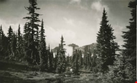
The Castle from the Meadows
https://search.heritageburnaby.ca/link/archivedescription51447
- Repository
- City of Burnaby Archives
- Date
- 1938
- Collection/Fonds
- Burnaby Historical Society fonds
- Description Level
- Item
- Physical Description
- 1 photograph : b&w postcard ; 8 x 12.5 cm, mounted on heavy-weight paper 17.5 x 26.5 cm
- Scope and Content
- Photographic postcard of the Castle (Castlecrag Mountain) and Mount Frink taken from the meadows. A man is standing at the edge of the tree line, looking towards the mountains. This was part of a trip to the Forbidden Plateau on Vancouver Island made by a small party of City of Courtenay officials.…
- Repository
- City of Burnaby Archives
- Date
- 1938
- Collection/Fonds
- Burnaby Historical Society fonds
- Subseries
- George Grant subseries
- Physical Description
- 1 photograph : b&w postcard ; 8 x 12.5 cm, mounted on heavy-weight paper 17.5 x 26.5 cm
- Description Level
- Item
- Record No.
- 243-052
- Access Restriction
- No restrictions
- Reproduction Restriction
- No known restrictions
- Accession Number
- BHS1990-06
- Scope and Content
- Photographic postcard of the Castle (Castlecrag Mountain) and Mount Frink taken from the meadows. A man is standing at the edge of the tree line, looking towards the mountains. This was part of a trip to the Forbidden Plateau on Vancouver Island made by a small party of City of Courtenay officials. George A. Grant was one of the climbers in the party.
- Media Type
- Photograph
- Notes
- Title taken from handwritten title on paper mount
- Handwritten note on on facing page reads: "A million years of the winds and the weather - / Still monarch of all I survey / Forbidden? Not to the lovers of heather / And the beauties of nature gay / So I welcome you to my lofty towers / My rock gardens, lakes and my streams / Come and walk among my beautiful flowers / And then see them always - in dreams. / And ever anon when far down below me / Loading lives of pleasure or care / Refreshing will be your most fond memory / Your Castle, way up in the air. / G.A.G."
Images

Herbert Yee Law family fonds
https://search.heritageburnaby.ca/link/museumdescription18929
- Repository
- Burnaby Village Museum
- Date
- [1938-1959] (date of originals), 2017-2019 (date of duplication)
- Collection/Fonds
- Herbert Yee Law family fonds
- Description Level
- Fonds
- Physical Description
- 4 photographs (tiffs + jpgs)
- Scope and Content
- Fonds consists of a collection of photographs of Herbert Yee Law, United Fruit Growers, his farm on Marine Drive and a scanned copy of a survey plan of District Lots 163, 162, 157, 158 and 165.
- Repository
- Burnaby Village Museum
- Collection/Fonds
- Herbert Yee Law family fonds
- Description Level
- Fonds
- Physical Description
- 4 photographs (tiffs + jpgs)
- Scope and Content
- Fonds consists of a collection of photographs of Herbert Yee Law, United Fruit Growers, his farm on Marine Drive and a scanned copy of a survey plan of District Lots 163, 162, 157, 158 and 165.
- History
- Herbert (Yee) Law was born in New Westminster British Columbia in 1916. Between 1938 and 1945, Yee Law worked for the United Fraser Growers Limited in Vancouver. The company was a wholesaler that purchased produce from Chinese farmers. In 1948 Yee Law purchased land from another Chinese family along Marine Drive in the Big Bend Area of Burnaby. From this location, Yee Law operated a Chinese market garden. Yee Law and his wife Jean had five daughters who attended schools in the area including Riverway West School, McPherson Park School and Burnaby South High School. In 1954, Yee Law continued to live in the area but left his farm to work for a plastic bag company on Annacis Island. Herbert (Yee) Law died in 2003.
- Creator
- Law, Yee "Herbert"
- Accession Code
- BV017.40
- BV019.11
- Date
- [1938-1959] (date of originals), 2017-2019 (date of duplication)
- Media Type
- Photograph
- Cartographic Material
- Notes
- Title based on contents of fonds
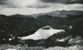
Moat Lake
https://search.heritageburnaby.ca/link/archivedescription51451
- Repository
- City of Burnaby Archives
- Date
- 1938
- Collection/Fonds
- Burnaby Historical Society fonds
- Description Level
- Item
- Physical Description
- 1 photograph : b&w postcard ; 13 x 8 cm, mounted on heavy-weight paper 17.5 x 26.5 cm
- Scope and Content
- Photographic postcard of Moat Lake nestled among the mountains of the Forbidden Plateau on Vancouver Island. This was part of a trip made by a small party of City of Courtenay officials. George A. Grant was one of the climbers in the party.
- Repository
- City of Burnaby Archives
- Date
- 1938
- Collection/Fonds
- Burnaby Historical Society fonds
- Subseries
- George Grant subseries
- Physical Description
- 1 photograph : b&w postcard ; 13 x 8 cm, mounted on heavy-weight paper 17.5 x 26.5 cm
- Description Level
- Item
- Record No.
- 243-056
- Access Restriction
- No restrictions
- Reproduction Restriction
- No known restrictions
- Accession Number
- BHS1990-06
- Scope and Content
- Photographic postcard of Moat Lake nestled among the mountains of the Forbidden Plateau on Vancouver Island. This was part of a trip made by a small party of City of Courtenay officials. George A. Grant was one of the climbers in the party.
- Media Type
- Photograph
- Photographer
- Tait, Preston L.
- Notes
- Title taken from handwritten title on paper mount
- Handwritten note on facing page reads: "So shall thy wondering sight at once survey / Vales, lakes, woods, mountains, islands, rocks and sea / Huge hills that heaped in crowded order stand / Stretched o'er the northern and the western land / Thomas Russell"
- Photographer identifies photograph as no. 835
Images

Riverway West School Parent-Teachers Association subseries
https://search.heritageburnaby.ca/link/archivedescription110
- Repository
- City of Burnaby Archives
- Date
- 1923-1967
- Collection/Fonds
- Burnaby Historical Society fonds
- Description Level
- Subseries
- Physical Description
- 1 scrapbook.
- Scope and Content
- Subseries consists of a Riverway West School PTA scrapbook and photographs.
- Repository
- City of Burnaby Archives
- Date
- 1923-1967
- Collection/Fonds
- Burnaby Historical Society fonds
- Physical Description
- 1 scrapbook.
- Description Level
- Subseries
- Accession Number
- BHS1992-03
- Scope and Content
- Subseries consists of a Riverway West School PTA scrapbook and photographs.
- History
- The original Riverway West School was a one room school house built in 1923 just west of the ravine at Sussex Avenue and Marine Drive. Miss Marion Swanson was the first teacher at the school ande Mr. Morrison its first custodian. Miss Carrie Kidd taught from 1924 to 1935, with the enrolment increasing from 18 in 1924 to 42 pupils in 1929, and including grades one to seven. In 1930 grades one to four were at Riverway while the older students went to Nelson. It continued on as a one-room school of four grades until 1952. As the school was seen by parents to be “greatly lacking” for students and teachers “in comfortable accommodations and vital equipment necessary for their extra curricular and recreational needs, such as were enjoyed by children in the larger schools” they formed a parent-teacher association in September 1951 to remedy the situation. From the beginning the PTA was very active in making its desires known to the School Board and “the school was very fortunate to have an organisation which put forth such a united effort on behalf of the children”. Their first bazaar fundraiser allowed the PTA to purchase a hot plate and the necessary utensils to provide the students with soup and cocoa during the cold weather. At their request, the School Board improved the electrical wiring in the school and built a roof over the stairs to the basement and provided more sports equipment for the children. Art classes and piano classes were started through the efforts of the members and in 1953 a cub pack and a brownie pack with PTA members as Cub Leaders and Brownie Leaders was created. A ditto machine and school library were the direct results of successful bazaars held by the PTA. The PTA also made a survey of the school district in 1951 to analyse the future school population and presented the results to the School Board. Following this, a portable unit was erected beside the existing school house for use the following September. It was in use until 1958. In the late 1950s, the PTA approached the School Board and the Burnaby Parks and Recreation Commission and proposed a park on the grounds adjacent to their school to relieve a playfield deficiency. The creation of Riverway West Park was the direct result of this proposal. As Parks Planner Paul Stocksted pointed out in 1961, “All of this would not have been possible had not the people associated with the PTA insisted on the solution to the problem of inadequate play areas.” In 1957 the first unit of the new Riverway West School underwent construction. Designed by Carlberg and Jackson with Remigio Maniaga as the contractor, it was completed in September of 1957 and consisted of four classrooms, an activity room and administration facilities. A two classroom addition, also designed by Carlberg and Jackson. was completed on the last day of 1959, three months after its construction began.
- Media Type
- Textual Record
- Photograph
- Notes
- PC273, MSS068
- Title based on creator and contents of subseries