More like 'Academic Quadrangle construction'
Narrow Results By
Subject
- Advertising Medium - Signs and Signboards 3
- Agriculture - Crops 2
- Agriculture - Farms 8
- Animals - Dogs 6
- Animals - Horses 4
- Buildings 3
- Buildings - Agricultural 3
- Buildings - Agricultural - Barns 6
- Buildings - Agricultural - Greenhouses 3
- Buildings - Agricultural - Nurseries 1
- Buildings - Civic 2
- Buildings - Civic - Archives 1
![Bellinger family home, [1936 or 1937] (date of original), copied 1991 thumbnail](/media/hpo/_Data/_Archives_Images/_Unrestricted/370/370-049.jpg?width=280)
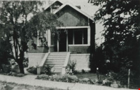
Bellinger family home
https://search.heritageburnaby.ca/link/archivedescription37461
- Repository
- City of Burnaby Archives
- Date
- [1936 or 1937] (date of original), copied 1991
- Collection/Fonds
- Burnaby Historical Society fonds
- Description Level
- Item
- Physical Description
- 1 photograph : b&w ; 2.8 x 4.1 cm print on contact sheet 20.2 x 25.3 cm
- Scope and Content
- Photograph of the Bellinger family home at 2827 Earl Avenue (later 6296 Pearl Avenue), following alterations of the front porch.
- Repository
- City of Burnaby Archives
- Date
- [1936 or 1937] (date of original), copied 1991
- Collection/Fonds
- Burnaby Historical Society fonds
- Subseries
- Burnaby Image Bank subseries
- Physical Description
- 1 photograph : b&w ; 2.8 x 4.1 cm print on contact sheet 20.2 x 25.3 cm
- Description Level
- Item
- Record No.
- 370-049
- Access Restriction
- No restrictions
- Reproduction Restriction
- No known restrictions
- Accession Number
- BHS1999-03
- Scope and Content
- Photograph of the Bellinger family home at 2827 Earl Avenue (later 6296 Pearl Avenue), following alterations of the front porch.
- Subjects
- Buildings - Residential - Houses
- Media Type
- Photograph
- Photographer
- Bellinger, Bernard
- Notes
- Title based on contents of photograph
- 1 b&w copy negative accompanying
- Item no. 370-047 and 370-048 are of house before and during renovations
- Geographic Access
- Pearl Avenue
- Street Address
- 6296 Pearl Avenue
- Historic Neighbourhood
- Central Park (Historic Neighbourhood)
- Planning Study Area
- Windsor Area
Images
![Bellinger family home, [1936 or 1937] (date of original), copied 1991 thumbnail](/media/hpo/_Data/_Archives_Images/_Unrestricted/370/370-049.jpg)
![Bellinger family home, [1934] (date of original), copied 1991 thumbnail](/media/hpo/_Data/_Archives_Images/_Unrestricted/370/370-058.jpg?width=280)
Bellinger family home
https://search.heritageburnaby.ca/link/archivedescription37470
- Repository
- City of Burnaby Archives
- Date
- [1934] (date of original), copied 1991
- Collection/Fonds
- Burnaby Historical Society fonds
- Description Level
- Item
- Physical Description
- 1 photograph : b&w ; 4.2 x 2.7 cm print on contact sheet 20.2 x 25.3 cm
- Scope and Content
- Photograph of the front of the Bellinger family home at 2827 Earl Avenue (later 6296 Pearl Avenue).
- Repository
- City of Burnaby Archives
- Date
- [1934] (date of original), copied 1991
- Collection/Fonds
- Burnaby Historical Society fonds
- Subseries
- Burnaby Image Bank subseries
- Physical Description
- 1 photograph : b&w ; 4.2 x 2.7 cm print on contact sheet 20.2 x 25.3 cm
- Description Level
- Item
- Record No.
- 370-058
- Access Restriction
- No restrictions
- Reproduction Restriction
- No known restrictions
- Accession Number
- BHS1999-03
- Scope and Content
- Photograph of the front of the Bellinger family home at 2827 Earl Avenue (later 6296 Pearl Avenue).
- Subjects
- Buildings - Residential - Houses
- Media Type
- Photograph
- Photographer
- Bellinger, Bernard
- Notes
- Title based on contents of photograph
- 1 b&w copy negative accompanying
- Geographic Access
- Pearl Avenue
- Street Address
- 6296 Pearl Avenue
- Historic Neighbourhood
- Central Park (Historic Neighbourhood)
- Planning Study Area
- Windsor Area
Images
![Bellinger family home, [1934] (date of original), copied 1991 thumbnail](/media/hpo/_Data/_Archives_Images/_Unrestricted/370/370-058.jpg)
![Billy Banks and friend, [1931] (date of original), copied 1991 thumbnail](/media/hpo/_Data/_Archives_Images/_Unrestricted/370/370-083.jpg?width=280)
Billy Banks and friend
https://search.heritageburnaby.ca/link/archivedescription37495
- Repository
- City of Burnaby Archives
- Date
- [1931] (date of original), copied 1991
- Collection/Fonds
- Burnaby Historical Society fonds
- Description Level
- Item
- Physical Description
- 1 photograph : b&w ; 3.2 x 2.8 cm print on contact sheet 20.2 x 25.3 cm
- Scope and Content
- Photograph of Billy Banks (left) and a friend at the back of Burnaby Garage and in front of the Banks family home at 1812 Britton Street and Kingsway (later renumbered 7383 Britton Street).
- Repository
- City of Burnaby Archives
- Date
- [1931] (date of original), copied 1991
- Collection/Fonds
- Burnaby Historical Society fonds
- Subseries
- Burnaby Image Bank subseries
- Physical Description
- 1 photograph : b&w ; 3.2 x 2.8 cm print on contact sheet 20.2 x 25.3 cm
- Description Level
- Item
- Record No.
- 370-083
- Access Restriction
- No restrictions
- Reproduction Restriction
- No known restrictions
- Accession Number
- BHS1999-03
- Scope and Content
- Photograph of Billy Banks (left) and a friend at the back of Burnaby Garage and in front of the Banks family home at 1812 Britton Street and Kingsway (later renumbered 7383 Britton Street).
- Subjects
- Buildings - Residential - Houses
- Names
- Banks, Billy
- Media Type
- Photograph
- Notes
- Title based on contents of photograph
- 1 b&w copy negative accompanying
- Annotation at bottom of photograph reads; "Billy"
- Geographic Access
- Britton Street
- Street Address
- 7383 Britton Street
- Historic Neighbourhood
- Edmonds (Historic Neighbourhood)
- Planning Study Area
- Stride Avenue Area
Images
![Billy Banks and friend, [1931] (date of original), copied 1991 thumbnail](/media/hpo/_Data/_Archives_Images/_Unrestricted/370/370-083.jpg)
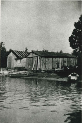
Boat sheds
https://search.heritageburnaby.ca/link/archivedescription35662
- Repository
- City of Burnaby Archives
- Date
- 1930 (date of original), copied 1986
- Collection/Fonds
- Burnaby Historical Society fonds
- Description Level
- Item
- Physical Description
- 1 photograph : b&w ; 12.7 x 17.8 cm print
- Scope and Content
- Photograph of Burnaby salmon fleet boat sheds, between the foot of Sussex (if it continued to the water) and the foot of Byrne along the north arm of the Fraser River. JS 6554 is Joe Stacey's 30-foot gillnetter.
- Repository
- City of Burnaby Archives
- Date
- 1930 (date of original), copied 1986
- Collection/Fonds
- Burnaby Historical Society fonds
- Subseries
- Pioneer Tales subseries
- Physical Description
- 1 photograph : b&w ; 12.7 x 17.8 cm print
- Description Level
- Item
- Record No.
- 204-520
- Access Restriction
- No restrictions
- Reproduction Restriction
- No known restrictions
- Accession Number
- BHS1988-03
- Scope and Content
- Photograph of Burnaby salmon fleet boat sheds, between the foot of Sussex (if it continued to the water) and the foot of Byrne along the north arm of the Fraser River. JS 6554 is Joe Stacey's 30-foot gillnetter.
- Media Type
- Photograph
- Notes
- Title based on contents of photograph
- Geographic Access
- Burnaby Fraser Foreshore Park
- Historic Neighbourhood
- Fraser Arm (Historic Neighbourhood)
- Planning Study Area
- Big Bend Area
Images
![Brown-John trucking office, [1935] (date of original), digitally copied 2012 thumbnail](/media/hpo/_Data/_Archives_Images/_Unrestricted/540/549-013.jpg?width=280)
Brown-John trucking office
https://search.heritageburnaby.ca/link/archivedescription76896
- Repository
- City of Burnaby Archives
- Date
- [1935] (date of original), digitally copied 2012
- Collection/Fonds
- Community Heritage Commission Special Projects fonds
- Description Level
- Item
- Physical Description
- 1 photograph (jpeg) : col. ; 300ppi
- Scope and Content
- Photograph of the Brown-John trucking office.
- Repository
- City of Burnaby Archives
- Date
- [1935] (date of original), digitally copied 2012
- Collection/Fonds
- Community Heritage Commission Special Projects fonds
- Physical Description
- 1 photograph (jpeg) : col. ; 300ppi
- Description Level
- Item
- Record No.
- 549-013
- Access Restriction
- No restrictions
- Reproduction Restriction
- No known restrictions
- Accession Number
- 2012-30
- Scope and Content
- Photograph of the Brown-John trucking office.
- Subjects
- Buildings - Commercial
- Media Type
- Photograph
- Notes
- Title based on contents of photograph
- Geographic Access
- Hastings Street
- Historic Neighbourhood
- Vancouver Heights (Historic Neighbourhood)
- Planning Study Area
- Willingdon Heights Area
Images
![Brown-John trucking office, [1935] (date of original), digitally copied 2012 thumbnail](/media/hpo/_Data/_Archives_Images/_Unrestricted/540/549-013.jpg)
![Building site, [1938] thumbnail](/media/hpo/_Data/_Archives_Images/_Unrestricted/550/550-246.jpg?width=280)
Building site
https://search.heritageburnaby.ca/link/archivedescription82693
- Repository
- City of Burnaby Archives
- Date
- [1938]
- Collection/Fonds
- Hill family and Vidal family fonds
- Description Level
- Item
- Physical Description
- 1 photograph : sepia ; 5.5 x 4 cm
- Scope and Content
- Photograph shows trees poking out of the roof of a building that is most likely Yellow Point Lodge.
- Repository
- City of Burnaby Archives
- Date
- [1938]
- Collection/Fonds
- Hill family and Vidal family fonds
- Physical Description
- 1 photograph : sepia ; 5.5 x 4 cm
- Description Level
- Item
- Record No.
- 550-246
- Access Restriction
- No restrictions
- Reproduction Restriction
- No known restrictions
- Accession Number
- 2013-03
- Scope and Content
- Photograph shows trees poking out of the roof of a building that is most likely Yellow Point Lodge.
- Media Type
- Photograph
- Notes
- Title based on contents of photograph
Images
![Building site, [1938] thumbnail](/media/hpo/_Data/_Archives_Images/_Unrestricted/550/550-246.jpg)
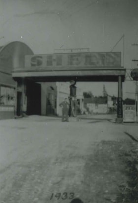
Burnaby Garage
https://search.heritageburnaby.ca/link/archivedescription37497
- Repository
- City of Burnaby Archives
- Date
- 1933 (date of original), copied 1991
- Collection/Fonds
- Burnaby Historical Society fonds
- Description Level
- Item
- Physical Description
- 1 photograph : b&w ; 4.1 x 3.2 cm print on contact sheet 20.2 x 25.3 cm
- Scope and Content
- Photograph of a front view of Burnaby Garage at 1869 Kingsway and Britton Street (later renumbered as the 7300 block of Kingsway). A man is standing in front of a gas pump. A sign above the pump reads, "Shell."
- Repository
- City of Burnaby Archives
- Date
- 1933 (date of original), copied 1991
- Collection/Fonds
- Burnaby Historical Society fonds
- Subseries
- Burnaby Image Bank subseries
- Physical Description
- 1 photograph : b&w ; 4.1 x 3.2 cm print on contact sheet 20.2 x 25.3 cm
- Description Level
- Item
- Record No.
- 370-085
- Access Restriction
- No restrictions
- Reproduction Restriction
- No known restrictions
- Accession Number
- BHS1999-03
- Scope and Content
- Photograph of a front view of Burnaby Garage at 1869 Kingsway and Britton Street (later renumbered as the 7300 block of Kingsway). A man is standing in front of a gas pump. A sign above the pump reads, "Shell."
- Names
- Burnaby Garage
- Media Type
- Photograph
- Notes
- Title based on contents of photograph
- 1 b&w copy negative accompanying
- Geographic Access
- Kingsway
- Historic Neighbourhood
- Edmonds (Historic Neighbourhood)
- Planning Study Area
- Stride Avenue Area
Images
![Burnie Feedham at the Quesnel Hotel, [193-] thumbnail](/media/hpo/_Data/_Archives_Images/_Unrestricted/204/204-599.jpg?width=280)
Burnie Feedham at the Quesnel Hotel
https://search.heritageburnaby.ca/link/archivedescription35741
- Repository
- City of Burnaby Archives
- Date
- [193-]
- Collection/Fonds
- Burnaby Historical Society fonds
- Description Level
- Item
- Physical Description
- 1 photograph : b&w ; 12.7 x 17.8 cm print
- Scope and Content
- Photograph the Quesnel Hotel, Quesnel, B.C., owned by Burnie Feedham. Identified (on horseback, left) Burnie Feedham. He introduced box lacrosse into the B.C. Interior. This hotel was later managed by his son, Ray.
- Repository
- City of Burnaby Archives
- Date
- [193-]
- Collection/Fonds
- Burnaby Historical Society fonds
- Subseries
- Pioneer Tales subseries
- Physical Description
- 1 photograph : b&w ; 12.7 x 17.8 cm print
- Description Level
- Item
- Record No.
- 204-599
- Access Restriction
- No restrictions
- Reproduction Restriction
- No known restrictions
- Accession Number
- BHS1988-03
- Scope and Content
- Photograph the Quesnel Hotel, Quesnel, B.C., owned by Burnie Feedham. Identified (on horseback, left) Burnie Feedham. He introduced box lacrosse into the B.C. Interior. This hotel was later managed by his son, Ray.
- Media Type
- Photograph
- Notes
- Title based on contents of photograph
Images
![Burnie Feedham at the Quesnel Hotel, [193-] thumbnail](/media/hpo/_Data/_Archives_Images/_Unrestricted/204/204-599.jpg)

Burrard Inlet Squatters
https://search.heritageburnaby.ca/link/archivedescription35583
- Repository
- City of Burnaby Archives
- Date
- 1930 (date of original), copied 1986
- Collection/Fonds
- Burnaby Historical Society fonds
- Description Level
- Item
- Physical Description
- 1 photograph : b&w ; 12.7 x 17.8 cm print
- Scope and Content
- Photograph of squatters in "Crabtown" along Burrard Inlet. Squatters proliferated during Great Depression, not eliminated until 1950s. Many of shacks were brightly decorated, attractive and clean. This photograph was taken looking West along the southern shoreline (Burnaby side) of Burrard Inlet.
- Repository
- City of Burnaby Archives
- Date
- 1930 (date of original), copied 1986
- Collection/Fonds
- Burnaby Historical Society fonds
- Subseries
- Pioneer Tales subseries
- Physical Description
- 1 photograph : b&w ; 12.7 x 17.8 cm print
- Description Level
- Item
- Record No.
- 204-441
- Access Restriction
- No restrictions
- Reproduction Restriction
- No known restrictions
- Accession Number
- BHS1988-03
- Scope and Content
- Photograph of squatters in "Crabtown" along Burrard Inlet. Squatters proliferated during Great Depression, not eliminated until 1950s. Many of shacks were brightly decorated, attractive and clean. This photograph was taken looking West along the southern shoreline (Burnaby side) of Burrard Inlet.
- Subjects
- Buildings - Residential - Houses
- Geographic Features - Inlets
- Persons - Residents - Squatters
- Media Type
- Photograph
- Notes
- Title based on contents of photograph
Images

Cambell family home
https://search.heritageburnaby.ca/link/archivedescription35786
- Repository
- City of Burnaby Archives
- Date
- 1930 (date of original), copied 1986
- Collection/Fonds
- Burnaby Historical Society fonds
- Description Level
- Item
- Physical Description
- 1 photograph : b&w ; 12.7 x 17.8 cm print
- Scope and Content
- Photograph of the second Campbell family home at 4120 Eton Street. John Campbell, the family's father, and his friends built this larger house, and then razed the former one on the lot.
- Repository
- City of Burnaby Archives
- Date
- 1930 (date of original), copied 1986
- Collection/Fonds
- Burnaby Historical Society fonds
- Subseries
- Pioneer Tales subseries
- Physical Description
- 1 photograph : b&w ; 12.7 x 17.8 cm print
- Description Level
- Item
- Record No.
- 204-644
- Access Restriction
- No restrictions
- Reproduction Restriction
- No known restrictions
- Accession Number
- BHS1988-03
- Scope and Content
- Photograph of the second Campbell family home at 4120 Eton Street. John Campbell, the family's father, and his friends built this larger house, and then razed the former one on the lot.
- Subjects
- Buildings - Residential - Houses
- Media Type
- Photograph
- Notes
- Title based on contents of photograph
- The former home on this lot is photo 204-643
- Geographic Access
- Eton Street
- Street Address
- 4120 Eton Street
- Historic Neighbourhood
- Vancouver Heights (Historic Neighbourhood)
- Planning Study Area
- Burnaby Heights Area
Images

Campend
https://search.heritageburnaby.ca/link/archivedescription35144
- Repository
- City of Burnaby Archives
- Date
- 1938 (date of original), copied 1986
- Collection/Fonds
- Burnaby Historical Society fonds
- Description Level
- Item
- Physical Description
- 1 photograph : b&w ; 12.7 x 17.8 cm print
- Scope and Content
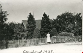
- Photograph of "Campend," the Shankie family home. Janet Shankie is standing in the gateway. The house was formerly numbered 3718 Barker Avenue and later renumbered 5155 Barker Avenue. An annotation at the bottom front of the photograph reads, "Campend 1938."
- Repository
- City of Burnaby Archives
- Date
- 1938 (date of original), copied 1986
- Collection/Fonds
- Burnaby Historical Society fonds
- Subseries
- Pioneer Tales subseries
- Physical Description
- 1 photograph : b&w ; 12.7 x 17.8 cm print
- Description Level
- Item
- Record No.
- 204-001
- Access Restriction
- No restrictions
- Reproduction Restriction
- No known restrictions
- Accession Number
- BHS1988-03
- Scope and Content
- Photograph of "Campend," the Shankie family home. Janet Shankie is standing in the gateway. The house was formerly numbered 3718 Barker Avenue and later renumbered 5155 Barker Avenue. An annotation at the bottom front of the photograph reads, "Campend 1938."
- Subjects
- Buildings - Residential - Houses
- Names
- Bower, Janet Shankie
- Media Type
- Photograph
- Notes
- Title based on caption on photograph
- Geographic Access
- Barker Avenue
- Street Address
- 5155 Barker Avenue
- Historic Neighbourhood
- Central Park (Historic Neighbourhood)
- Planning Study Area
- Garden Village Area
Images

![Car in Front of 510 North Boundary Road, [1930] (date of original), copied ca. 2000 thumbnail](/media/Hpo/_Data/_Archives_Images/_Unrestricted/371/407-011.jpg?width=280)
Car in Front of 510 North Boundary Road
https://search.heritageburnaby.ca/link/archivedescription38336
- Repository
- City of Burnaby Archives
- Date
- [1930] (date of original), copied ca. 2000
- Collection/Fonds
- Burnaby Historical Society fonds
- Description Level
- Item
- Physical Description
- 1 photograph : b&w ; 8.8 x 12.7 cm print
- Scope and Content
- Photograph of a man and a woman sitting in a car in front of 510 North Boundary Road - both are unidentified.
- Repository
- City of Burnaby Archives
- Date
- [1930] (date of original), copied ca. 2000
- Collection/Fonds
- Burnaby Historical Society fonds
- Subseries
- Photographs subseries
- Physical Description
- 1 photograph : b&w ; 8.8 x 12.7 cm print
- Description Level
- Item
- Record No.
- 407-011
- Access Restriction
- No restrictions
- Reproduction Restriction
- No known restrictions
- Accession Number
- BHS2007-04
- Scope and Content
- Photograph of a man and a woman sitting in a car in front of 510 North Boundary Road - both are unidentified.
- Media Type
- Photograph
- Notes
- Title based on contents of photograph.
Images
![Car in Front of 510 North Boundary Road, [1930] (date of original), copied ca. 2000 thumbnail](/media/Hpo/_Data/_Archives_Images/_Unrestricted/371/407-011.jpg)
![Central Park Interurban trams, [1930] (date of original), copied 1986 thumbnail](/media/hpo/_Data/_Archives_Images/_Unrestricted/204/204-370.jpg?width=280)
Central Park Interurban trams
https://search.heritageburnaby.ca/link/archivedescription35512
- Repository
- City of Burnaby Archives
- Date
- [1930] (date of original), copied 1986
- Collection/Fonds
- Burnaby Historical Society fonds
- Description Level
- Item
- Physical Description
- 1 photograph : b&w ; 12.7 x 17.8 cm print
- Scope and Content
- Photograph of Central Park Interurban trams at Royal Oak Station. Jimmy Strachan, the motorman, is not visible.
- Repository
- City of Burnaby Archives
- Date
- [1930] (date of original), copied 1986
- Collection/Fonds
- Burnaby Historical Society fonds
- Subseries
- Pioneer Tales subseries
- Physical Description
- 1 photograph : b&w ; 12.7 x 17.8 cm print
- Description Level
- Item
- Record No.
- 204-370
- Access Restriction
- No restrictions
- Reproduction Restriction
- No known restrictions
- Accession Number
- BHS1988-03
- Scope and Content
- Photograph of Central Park Interurban trams at Royal Oak Station. Jimmy Strachan, the motorman, is not visible.
- Media Type
- Photograph
- Notes
- Title based on contents of photograph
- Geographic Access
- Central Park Interurban line
- Historic Neighbourhood
- Central Park (Historic Neighbourhood)
- Planning Study Area
- Windsor Area
Images
![Central Park Interurban trams, [1930] (date of original), copied 1986 thumbnail](/media/hpo/_Data/_Archives_Images/_Unrestricted/204/204-370.jpg)
![Chamberlain Nurseries, [1939] (date of original), copied 1986 thumbnail](/media/hpo/_Data/_Archives_Images/_Unrestricted/126/179-001.jpg?width=280)
Chamberlain Nurseries
https://search.heritageburnaby.ca/link/archivedescription35030
- Repository
- City of Burnaby Archives
- Date
- [1939] (date of original), copied 1986
- Collection/Fonds
- Burnaby Historical Society fonds
- Description Level
- Item
- Physical Description
- 1 photograph : b&w ; 8.8 x 12.6 cm print
- Scope and Content
- Photograph of Chamberlain Nurseries, 6389 Elgin Avenue, and surrounding land.
- Repository
- City of Burnaby Archives
- Date
- [1939] (date of original), copied 1986
- Collection/Fonds
- Burnaby Historical Society fonds
- Subseries
- Chamberlain family subseries
- Physical Description
- 1 photograph : b&w ; 8.8 x 12.6 cm print
- Description Level
- Item
- Record No.
- 179-001
- Access Restriction
- No restrictions
- Reproduction Restriction
- No known restrictions
- Accession Number
- BHS1986-27
- Scope and Content
- Photograph of Chamberlain Nurseries, 6389 Elgin Avenue, and surrounding land.
- Subjects
- Buildings - Agricultural - Nurseries
- Names
- Chamberlain Nurseries
- Media Type
- Photograph
- Notes
- Title based on contents of photograph
- Geographic Access
- Elgin Avenue
- Street Address
- 6389 Elgin Avenue
- Historic Neighbourhood
- Central Park (Historic Neighbourhood)
- Planning Study Area
- Windsor Area
Images
![Chamberlain Nurseries, [1939] (date of original), copied 1986 thumbnail](/media/hpo/_Data/_Archives_Images/_Unrestricted/126/179-001.jpg)
![Chamberlain's Greenhouses, [1936] (date of original), copied 1986 thumbnail](/media/hpo/_Data/_Archives_Images/_Unrestricted/126/179-007.jpg?width=280)
Chamberlain's Greenhouses
https://search.heritageburnaby.ca/link/archivedescription35036
- Repository
- City of Burnaby Archives
- Date
- [1936] (date of original), copied 1986
- Collection/Fonds
- Burnaby Historical Society fonds
- Description Level
- Item
- Physical Description
- 1 photograph : b&w ; 8.8 x 12.7 cm print
- Scope and Content
- Photograph of Chamberlain's greenhouses. A man is standing outside. This may be 6389 Elgin Avenue.
- Repository
- City of Burnaby Archives
- Date
- [1936] (date of original), copied 1986
- Collection/Fonds
- Burnaby Historical Society fonds
- Subseries
- Chamberlain family subseries
- Physical Description
- 1 photograph : b&w ; 8.8 x 12.7 cm print
- Description Level
- Item
- Record No.
- 179-007
- Access Restriction
- No restrictions
- Reproduction Restriction
- No known restrictions
- Accession Number
- BHS1986-27
- Scope and Content
- Photograph of Chamberlain's greenhouses. A man is standing outside. This may be 6389 Elgin Avenue.
- Names
- Chamberlain Nurseries
- Media Type
- Photograph
- Notes
- Title based on contents of photograph
- Street Address
- 6389 Elgin Avenue
- Historic Neighbourhood
- Central Park (Historic Neighbourhood)
- Planning Study Area
- Windsor Area
Images
![Chamberlain's Greenhouses, [1936] (date of original), copied 1986 thumbnail](/media/hpo/_Data/_Archives_Images/_Unrestricted/126/179-007.jpg)
![Chamberlain's Greenhouses, [1936] (date of original), copied 1986 thumbnail](/media/hpo/_Data/_Archives_Images/_Unrestricted/126/179-008.jpg?width=280)
Chamberlain's Greenhouses
https://search.heritageburnaby.ca/link/archivedescription35037
- Repository
- City of Burnaby Archives
- Date
- [1936] (date of original), copied 1986
- Collection/Fonds
- Burnaby Historical Society fonds
- Description Level
- Item
- Physical Description
- 1 photograph : b&w ; 8.6 x 12.7 cm print
- Scope and Content
- Photograph of the interior of Chamberlain's greenhouses at what may be 6389 Elgin Avenue.
- Repository
- City of Burnaby Archives
- Date
- [1936] (date of original), copied 1986
- Collection/Fonds
- Burnaby Historical Society fonds
- Subseries
- Chamberlain family subseries
- Physical Description
- 1 photograph : b&w ; 8.6 x 12.7 cm print
- Description Level
- Item
- Record No.
- 179-008
- Access Restriction
- No restrictions
- Reproduction Restriction
- No known restrictions
- Accession Number
- BHS1986-27
- Scope and Content
- Photograph of the interior of Chamberlain's greenhouses at what may be 6389 Elgin Avenue.
- Names
- Chamberlain Nurseries
- Media Type
- Photograph
- Notes
- Title based on contents of photograph
- Street Address
- 6389 Elgin Avenue
- Historic Neighbourhood
- Central Park (Historic Neighbourhood)
- Planning Study Area
- Windsor Area
Images
![Chamberlain's Greenhouses, [1936] (date of original), copied 1986 thumbnail](/media/hpo/_Data/_Archives_Images/_Unrestricted/126/179-008.jpg)
![Chemnitz, [1900-1930] thumbnail](/media/hpo/_Data/_Archives_Images/_Unrestricted/550/550-144.jpg?width=280)
Chemnitz
https://search.heritageburnaby.ca/link/archivedescription82573
- Repository
- City of Burnaby Archives
- Date
- [1900-1930]
- Collection/Fonds
- Hill family and Vidal family fonds
- Description Level
- Item
- Physical Description
- 1 photograph : col. postcard ; 9 x 14 cm
- Scope and Content
- Photographic postcard shows buildings in Chemnitz, Germany.
- Repository
- City of Burnaby Archives
- Date
- [1900-1930]
- Collection/Fonds
- Hill family and Vidal family fonds
- Physical Description
- 1 photograph : col. postcard ; 9 x 14 cm
- Description Level
- Item
- Record No.
- 550-144
- Access Restriction
- No restrictions
- Reproduction Restriction
- No known restrictions
- Accession Number
- 2013-03
- Scope and Content
- Photographic postcard shows buildings in Chemnitz, Germany.
- Subjects
- Buildings
- Media Type
- Photograph
- Notes
- Title based on contents of photograph
- Top of recto reads: "Chemnitz / Anfgang zum Schlossberg"
Images
![Chemnitz, [1900-1930] thumbnail](/media/hpo/_Data/_Archives_Images/_Unrestricted/550/550-144.jpg)
![Chemnitz, [1900-1930] thumbnail](/media/hpo/_Data/_Archives_Images/_Unrestricted/550/550-147.jpg?width=280)
Chemnitz
https://search.heritageburnaby.ca/link/archivedescription82579
- Repository
- City of Burnaby Archives
- Date
- [1900-1930]
- Collection/Fonds
- Hill family and Vidal family fonds
- Description Level
- Item
- Physical Description
- 1 photograph : b&w postcard ; 9 x 14 cm
- Scope and Content
- Photographic postcard shows buildings in Chemnitz, Germany.
- Repository
- City of Burnaby Archives
- Date
- [1900-1930]
- Collection/Fonds
- Hill family and Vidal family fonds
- Physical Description
- 1 photograph : b&w postcard ; 9 x 14 cm
- Description Level
- Item
- Record No.
- 550-147
- Access Restriction
- No restrictions
- Reproduction Restriction
- No known restrictions
- Accession Number
- 2013-03
- Scope and Content
- Photographic postcard shows buildings in Chemnitz, Germany.
- Subjects
- Buildings
- Media Type
- Photograph
- Notes
- Title based on contents of photograph
- Recto reads: "Chemnitz - Kuchwaldschanke"
Images
![Chemnitz, [1900-1930] thumbnail](/media/hpo/_Data/_Archives_Images/_Unrestricted/550/550-147.jpg)
![Chic Gilbert and Motocycle, [1930] (date of original), copied 1991 thumbnail](/media/hpo/_Data/_Archives_Images/_Unrestricted/370/370-084.jpg?width=280)
Chic Gilbert and Motocycle
https://search.heritageburnaby.ca/link/archivedescription37496
- Repository
- City of Burnaby Archives
- Date
- [1930] (date of original), copied 1991
- Collection/Fonds
- Burnaby Historical Society fonds
- Description Level
- Item
- Physical Description
- 1 photograph : b&w ; 4.1 x 2.7 cm print on contact sheet 20.2 x 25.3 cm
- Scope and Content
- Photograph of Chic Gilbert and a motorbike with a side car in front of Salisbury Garage, at 1996 Kingsway and Salisbury Avenue (later renumbered 7112 Kingsway).
- Repository
- City of Burnaby Archives
- Date
- [1930] (date of original), copied 1991
- Collection/Fonds
- Burnaby Historical Society fonds
- Subseries
- Burnaby Image Bank subseries
- Physical Description
- 1 photograph : b&w ; 4.1 x 2.7 cm print on contact sheet 20.2 x 25.3 cm
- Description Level
- Item
- Record No.
- 370-084
- Access Restriction
- No restrictions
- Reproduction Restriction
- No known restrictions
- Accession Number
- BHS1999-03
- Scope and Content
- Photograph of Chic Gilbert and a motorbike with a side car in front of Salisbury Garage, at 1996 Kingsway and Salisbury Avenue (later renumbered 7112 Kingsway).
- Media Type
- Photograph
- Notes
- Title based on contents of photograph
- 1 b&w copy negative accompanying
- Annotation at bottom of photograph reads, "Chic."
- Geographic Access
- Kingsway
- Street Address
- 7112 Kingsway
- Historic Neighbourhood
- Edmonds (Historic Neighbourhood)
- Planning Study Area
- Stride Avenue Area
Images
![Chic Gilbert and Motocycle, [1930] (date of original), copied 1991 thumbnail](/media/hpo/_Data/_Archives_Images/_Unrestricted/370/370-084.jpg)
Chicken Hatchery at Royal Oak and Kingsway
https://search.heritageburnaby.ca/link/archivedescription37335
- Repository
- City of Burnaby Archives
- Date
- 1935
- Collection/Fonds
- Burnaby Historical Society fonds
- Description Level
- Item
- Physical Description
- 1 photograph : b&w negative ; 6 x 8.5 cm
- Scope and Content
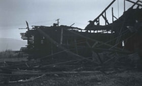
- Photograph of the remnants of a burned building that was a chicken hatchery at Royal Oak and Kingsway.
- Repository
- City of Burnaby Archives
- Date
- 1935
- Collection/Fonds
- Burnaby Historical Society fonds
- Subseries
- Bernard Bellinger subseries
- Physical Description
- 1 photograph : b&w negative ; 6 x 8.5 cm
- Description Level
- Item
- Record No.
- 354-001
- Access Restriction
- No restrictions
- Reproduction Restriction
- No known restrictions
- Accession Number
- BHS1997-13
- Scope and Content
- Photograph of the remnants of a burned building that was a chicken hatchery at Royal Oak and Kingsway.
- Subjects
- Buildings - Agricultural
- Media Type
- Photograph
- Notes
- Title based on contents of photograph.
- Geographic Access
- Royal Oak Avenue
- Kingsway
- Historic Neighbourhood
- Central Park (Historic Neighbourhood)
Images
